
-
 3631 Hits
-
 79.78% Score
-
 11 Votes
|
|
Mountain/Rock |
|---|---|
|
|
37.86810°N / 107.42393°W |
|
|
Hinsdale |
|
|
Hiking |
|
|
Spring, Summer, Fall, Winter |
|
|
13524 ft / 4122 m |
|
|
Overview
 Cataract Peak
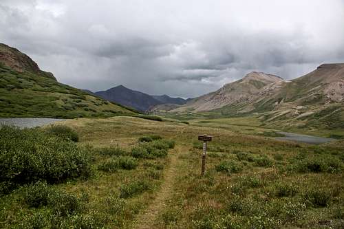 Continental Divide trail with 14er Sunshine Peak in the mid distance. Cataract Peak on the right.
 Guide to the Colorado Mountains with Robert Ormes provides only a brief mention: "Peaks 13,450' (Tundra Top) and 13,580' are easy ascents north and south respectively from where the trail (CDT) crosses at 12,900' pass. A bit more than 0.25 mile north of the former is Peak 13,524' (Cataract Peak). It would probably go by either its short west or east ridges, after dropping to the 1,.080' saddle from Peak 13,450'."
I chose a different route and it allowed me to completely avoid scree (see below).
Quad: Pole Creek Mountain
Parent Lineage: Carson Peak
Class: 2
Nearby Peaks:
- Tundra Top 0.60 miles
- Carson Peak 1.41 miles
- Quarter Peak 2.06 miles
- Unnamed 13580 B 2.12 miles
- Half Peak 2.35 miles
- Bent Peak 2.42 miles
- Unnamed 13581 2.67 miles
Getting There
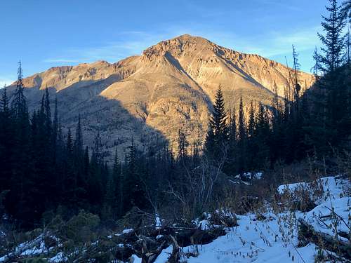 Sunshine Peak 14er as seen from Cataract Gulch
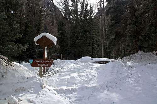 Cataract Gulch TH
Cataract Gulch: from Lake City take highway 149 south, 2.5 miles. Turn right onto the road to Lake San Cristobal (the same as for Water Gulch below). Follow the road for approximately 12.3 miles. At the fork in the road turn left toward Sherman and drive 1.4 miles. A sign marks the trailhead. Just beyond the parking area the trail crosses Cottonwood Creek on a bridge and then steeply ascends on switchbacks through forest. The trail crosses several times Cataract Creek. During the first 2 miles the hike gains over 2,000 feet. You get nice views through openings in the trees of Sunshine Peak (14,001') on the north side across the valley. Between 2-3 miles on the trail, you will get more open views and you should be able to see Half Peak (13,841') on the west side of the trail. At 3 miles the trails goes through an alpine meadow past a few tarns to Cataract Lake at 12,100 feet, 3.8 miles from the trailhead. It is another 0.3 miles from the lake to the Continental Divide trail.
Cataract Gulch Trail is better if you are planning for "Cataract Peak" and "Tundra Top". You don't need 4 WD vehicle for this approach.
Wager Gulch/Carson Pass: from the town of Lake City, drive south on highway 149 and then turn right onto County Road 30 to Lake San Cristobal, part of the scenic alpine loop drive (very popular in the summer). The road is paved past the lake then turns to graded dirt, passable for all passenger cars. About 2 miles past the Williams Creek campground, watch for a road turning off to the left (south) for the old townsite Carson. It is well signed as "Wager Gulch" road. From this point you need a high clearance 4 WD vehicle.
Head up the road through aspen and conifer forest. The road climbs steeply, higher up you will encounter a few primitive camping spots. The road was not very difficult, and I would almost say that the roughest section were lower down. I chose to stop at the old townsite of Carson since per other reports the road higher up was supposedly in a bad condition. However, as of October 2016, the road was good to go all the way to the Carson Pass. Carson Pass is not signed, but it is an obvious highest point of the road. There is plenty of parking. If you choose to park at the ghost town of Carson as I did, it will add about one mile to your hike, and some elevation gain. The Wager Gulch Road is about 5 miles long and the driving is slow.
Route
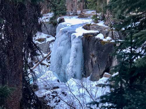 Cataract Trail - about 1.8 miles in you encounter this waterfall
 Cottonwood Creek
 Waterfall
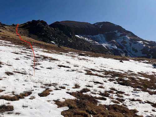
I chose the approach via Cataract Trail -just beyond the trailhead parking area the trail up Cataract Gulch crosses Cottonwood Creek on a bridge and steeply climbs up Cataract Gulch. The trail is in dense forest and views are limited, but you get nice views of 14er Sunshine Peak through the trees. Waterfalls and cascades along Cataract Creek are numerous and in the summer there are displays of wildflowers. At 1.8 miles you encounter a larger waterfall (see photo) and there is a nice campsite above it. I lost the trail here, it was all covered in snow. Soon, after the frozen waterfall, I left the trail and ascended west slopes towards the north ridge of Cataract Peak. The going was steep, but not hard. Higher up I encountered a cliff band with a weakness, short scree gully, not technically hard. Above that it was just a short stroll to the summit. See the link the gaia map below.
The summit has great views, small cairn and summit register.
Summit views
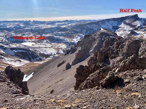 View into Grenadiers
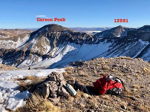 View southeast
Red Tape
The peak is located within Gunnison National Forest. There are no fees to hike, backpack, drive and park your vehicles.
When to Climb
Summer is obviously the easiest, but autumn and spring are excellent as well. Winter always check out the avalanche report.
The trailhead to Cataract Gulch is snowplowed all winter long. Cataract trail is initially easy to follow when snow covered, but after about 2 miles it can be harder to follow it.
If combining with other peaks, most people drive up Wager Gulch. The road is rough, north facing, and is a little bit over 5 miles long. It is closed in the winter.
Camping
Primitive camping past Sherman site/Cataract Gulch trailhead - multiple sites. I have also slept in a car at the Cataract Gulch TH.
Primitive camping along Wager Gulch road - higher up. The lower part of the road goes through some private property and the road is too narrow and steep to stop and find a parking spot.
Forest Service Campgrounds:
- Lake Cristobal: Wupperman campground, on the east side of Lake San Cristobal, 15$ per night, vault toilets, grills, picnic tables. Reservations possible.
- Williams Creek: no reservations. First Come, First Serve basis. 14$ per night. There is drinkable water. 23 campsites.
- Mill Creek Campground: 7$ per night, BLM campground, 22 sites.
I don't stay in campgrounds since there are so many options for primitive camping in a high country.
External Links
- Cataract Peak on List of John
- Cataract Peak on 13ers.com
- Cataract Lake AKA Cataract Gulch - nice description on hiking&walking