
|
|
Mountain/Rock |
|---|---|
|
|
44.77458°N / 5.83832°E |
|
|
Download GPX » View Route on Map |
|
|
Hiking, Mountaineering, Scrambling |
|
|
9150 ft / 2789 m |
|
|
Overview
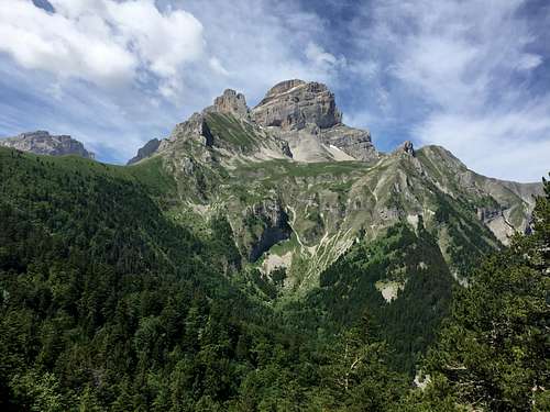
Grande Tete de l'Obiou is an ultra-prominent peak in the Dauphine Alps of Southeastern France, not far from the Italy border. The top of the mountain is 9,150 feet of elevation (2,790 Meters). And holds just enough prominence, 5,059 feet (1,542 meters) to be an ultra. I have done little hiking in the Alps (or Europe), but the views of this peak were astonishing from my hotel (Boustigue Hotel), the drive, and along the hike. A solid knarly rock sitting atop green fields, above green forest. It truly provides a picturesque scene.
Getting There
I wish I could provide better information here. I placed "Chalet Des Baumes" into Google Maps. If this is no longer working in Google Maps you may try 44°47'04.0"N 5°52'31.3"E for the parking area. This was, in fact, the correct place to park to start the hike. Unfortunately, the route provided by Google Maps included roads that no longer existed. I was able to pick through roads that do exist, using Google Maps as a guide, but often on roads not shown. Some of these roads were in rough shape. Fortunately on the way out I chose to follow the dirt road on which I parked. It stayed in good shape, and got me back to the hotel in a much better form.
If you have better information, or a map from a known point please share.
Route
To my knowledge there is only one route. This begins at Chalet Des Baumes (Col des Faïsses, Pellafol, France). A bit (0.1 miles) uphill, on the road, from Chalet Des Baumes a trail breaks from the road on the right hand side. The trail is worn well enough it can be easily followed. You're already above the majority of the trees and the views are wonderful, both up the mountain and away from the mountain. At ~1.3 miles on the trail (1.4 miles total) the trail splits. I believe going up most people stay to the right. The trail gains about 1,100 feet through this section.
Staying right the trail continues to gain elevation at not too steep of a rate for another ~0.9 miles gaining another 650 feet. (2.3 miles total)
Here the steepness increases noticabally. Switchbacks become a part of the route for the next 0.15 miles, at the top of the switchbacks the trail the had split away earlier reconnects. Following the switchbacks the route remains steep for another 0.3 miles then you reach the bottom of an area I've seen referred to as the stairs.
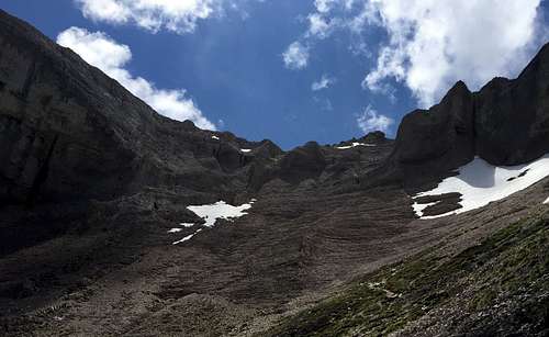
Starting here (or maybe a bit before) it's a good idea to wear a helmet. I was alone on the mountain and there were still a few small rock falls in this section. Because this is solid rock the worn trail is not as obvious, but the trail/route has been marked in red blaze. I'm not great at rating rock climbing route, but think the stairs would be considered class 3 (if someone experienced with this knows better please let us know). Following the stairs the rock fall hazard is gone. The stairs only last a tenth (0.1) of a mile. Here you're at a saddle that provides views of areas not previously available. The route remains steep here to the peak, another 0.7 miles. Through this section totalling 1.25 miles the route gains ~2,100 feet. (3.55 miles total)
For the return hike most people skip the switchbacks and take the alternative trail down. This is what I practiced as well. This takes you to a scree slope (which was mostly covered in ice while I was there). This route is shorter, but I certainly was happy I didn't take it up. The hike ended up as a total of 6.6 miles.
Red Tape
None that I'm aware of. Please do research yourself.
When to Climb
I'd guess June through Mid-October. My hike in mid-June still had some ice on the route. I was pushed off the route up the stairs for a bit. I'm sure some would love the challenge of a winter climb, but it would take much more preparation.
Camping
Add Camping text here.
External Links
https://peakbagger.com/peak.aspx?pid=13261