
-
 4307 Hits
-
 77.48% Score
-
 8 Votes
|
|
Mountain/Rock |
|---|---|
|
|
43.14397°N / 109.68385°W |
|
|
Hiking, Mountaineering, Skiing |
|
|
Spring, Summer, Fall |
|
|
13020 ft / 3968 m |
|
|
Overview
Bow Mountain is located in the Wind River Range, and is one of the 35 Wyoming 13ers (see the list here). It sits about 0.9 miles west of American Legion Peak, and a bit off the continental divide. Bow is probably one of the more accessible and easiest 13ers due to its proximity to the Jean Lakes/Shannon Pass trail which is hiked every summer by hundreds of backpackers. The normal route up the mountain is also mainly a class 2 romp, with just a short third class section. I can only assume Bow Mountain got its name due to the curved profile the peak displays when approaching from the south hiking by Jean Lakes. Adding Bow Mountain to a backpacking trip through the WInds would be a great way to get a high view of the ranges core and not commit to a super serious endevor.
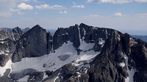
Directly adjacent just to the east of Bow Mountain lies Mount Arrowhead, a slightly lower, but much more impressive peak with wild and very steep sweeping faces on both the north and south sides. An alpine technical traverse between Bow and Arrowhead would make for an amazing outing on beautifully solid looking rock, not to mention the airy exposure on both sides of this knife ridge.
Getting There
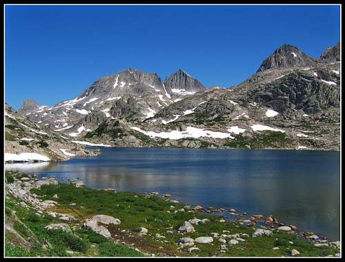
Use the Elkhart Park Trailhead accessed from Pinedale on the west side of the range and hike the Pole Creek Trail to Island Lake, passing by Photographers Point and Seneca Lake along the way. Just after passing over a small divide at 10,660 feet Island Lake will come into view. Just over the north side of this small divide there will be a trail junction. Continuing straight will take you to Island Lake and beyond, however to ascend Bow Mountain you'd take the junction to the left and follow this trail northwest towards Lower Jean Lake. The trail winds around, going over a few small hills before arriving at Fremont Crossing, where a bridge eliminates any need to wade. Continue past both the lower and Upper Jean Lakes to the junction with the Shannon Pass Trail, which is signed at 10970 feet just west of a tiny pond. Continue straight towards SHannon Pass, and hike up the hill just to the north for 150 feet, to where you can camp next to a small stream of water right below the SW face of Bow.
Route - SW Slopes to West Ridge - Class 3
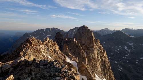
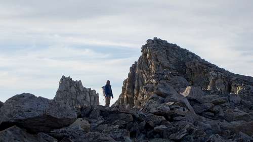
From camp just a short walk north of the Shannon Pass Trail Junction as described above, begin hiking northeast up the slopes above to the 11600 foot contour, then curve slightly left and continue north following the path of least resistence. The terrain should not exceed class 2. At 11800 feet there is a short steeper rock step that may require a few feet of class 3 scrambling to surmount. Curve slightly back to the northeast here and aim for the base of an obvious scree gully leading right to the ridgecrest above. The gully is not as bad as it looks and somewhat more solid boulders can be found on its left edge. Continue all the way to the 12620 foot notch immediately south of Brimstone Mountain. From here, scramble right and continue south. RIght away there will be some class 3 scrambling to pass a short rough section of the ridge but the easiest way is always straightforward to locate. Avoid any difficulties from the crest to the right (south side). Once past the class 3 zone, the terrain opens to class 2 boulders and this final ridge walk is an additional third of a mile to the ESE to the summit.
Red Tape/Camping
No red tape. Great Camping can be had near the Shannon Pass Trail Junction, either Jean Lake or Elbow Lake.
When to Climb
Best time for summer conditions will be July - Early September. Ski touring would be advisable before June. The initial hike towards Seneca Lakes dries out a little earlier, but tons of snow typically persists in Titcomb Basin past July 4th, but will normally dry out reasonably well shortly after mid July.
Map
This map shows the standard route up Bow Mountain with a brown line from a typical camp near the Shannon Pass Trail Junction.
External Links
My Trip Report of Mount Sacajawea, and all the other 13ers in the Wind Rivers