
|
|
Mountain/Rock |
|---|---|
|
|
36.39612°S / 148.28632°E |
|
|
Hiking, Mountaineering, Mixed, Scrambling, Skiing |
|
|
Overview
The Sentinel is a prominent peak on the western face of the Main Range. It is one of the most striking alpine peaks on the mainland with its diamond shape and knife edge ridge. It is one of the most difficult peaks to climb on the mainland due to the awkard scrambling with 300 metres of exposure along the southern face of the knife edge ridge. While dwarfed by the peaks that surround it it is one of the most worthwhile peaks to climb in the area. It is snow covered from June to October and offers great skiing and Alpine Climbing as well as a rare example of Mountaineering. The main run goes down its southeast face and is known as the 'Fridge Run". There is also skiing on the northern face as well, which is far steeper but has a reputation for avalanches. The Southwest face offers mixed alpine routes up to 250 m in length on granite, turf and snow, which has a steep snow couloir running through it which heads all the way down to the creek.
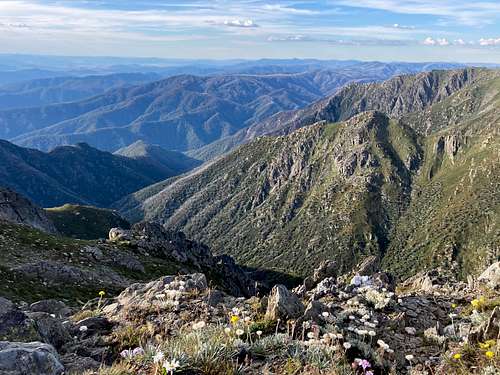
The Southern side of the Sentinel viewed from the higher Carruthers Peak
Getting There
From Jindabyne head west past the turn off to alpine way. Continue through the park entrance and stay on Kosciousko road past a few ski resorts. Park before the locked gate which leads to rawsons pass (this can fill up on sunny windless days) and start on the right leaning track that heads towards the snowy river.
When the Kosciusko road is closed in winter, head into park as normal but turn left at Guthega sign. from here drive up valley to ski resort, and park either at Illawong Trailhead or in the parking area in front of Guthega Inn.
Route
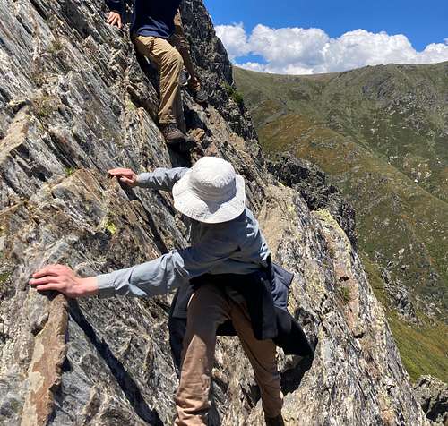
From the charlotte pass trailhead head down towards the Snowy River crossing it and climbing up the crummer spur on the track. After crossing a creek and climbing the other side of this valley head past the blue lake junction(worthwhile detour) and take the left fork. head up the hill for 300 or so metres and you will reach a junction with a "Main Range Track" sign. From here it is possible to see the Sentinel. Go right and climb up the grassy hill, keeping the sentinel in view. Continue until you can see the sentinel ridge moving off to the left. follow the ridge past a flat grassy cirque on your right and climb along the increasingly rocky ridge. start descending down the scree covered footpad passing down a few small cliffs. continue along the ridge climbing down a slippery ramp. The next section takes you across a flat section of ridge before the ridge is blocked by two gendarmes. Climb down the track for a few meters, before scrambing over the first rib. Then in a rocky gully scramble across the second rib. this is best avoided when wet or icy as the exposure is severe, and many of the moves are friction dependent. Then follow the ridge through the gap and up to the summit. Reverse the route to return.
The scrambling crux section
In winter start at Guthega from the Illawong trailhead. Depending on snow conditions hike or ski up the valley to Illawong hut. Here cross the suspension bridge and head up to Mt Twynam via a good snowcamping area. From mt twynam head west to the drop off and locate the sentinel. From here follow the main range until sentinel ridge branches off. Ski/bootpack down the ridge, and negotiating the gendarmes by downclimbing around them. from here bootpack up to the summit. This route requires a good understanding of the winter mounain environment including weather, avalanches and off track navigation in limited visiblity.
Red Tape
All vehicles need a parks pass puchased at the park entance or the Jindabyne visitor centre. It can cost anywhere fron $16-$22 depending on season. Wild camping is free but all waste must be carried out and fuel stoves only.
When to Climb
The peak is snow free from November onwards, but the most stable weather for hiking is in Feburary. It is on the western faces and as such is exposed to some of the worst weather in the country which means gales, rain and snow at any time of year, and westerly winds on most days. On sunny windless days from december onwards there are lots of biting flies, which need insect repellent to avoid.
The peak is snow covered from June onwards. due to its steepness Skiing is dictated by the local avalanche conditions. Skiiing on the sentinel is possible until october however this peak has a reputation for wet snow avalanches. Alpine climbing is in condition from June to August.
Camping
There are a few sheltered campsites close to the sentinel, however there are also large no camping areas in the catchements of the glacial lakes. While there are good views camping on the western faces, it is best to be in a valley on the eastern side. The valley directly behind the ridge that connects the sentinel and mt twynam, however is in the catchment of blue lake and a No Camping area. A good basecamp for the whole area exists 200 m upstram from the river crossing at Charlottes pass near a ruin, sheltered from the westerly winds and with the charlotte pass toilet 15 mins away. Paid Car camping is available at sawpit creek.
External Links
PLB Hire : https://www.nationalparks.nsw.gov.au/safety/bushwalking-safety/personal-locator-beacon
Main Range track offical page :https://www.nationalparks.nsw.gov.au/things-to-do/walking-tracks/main-range-walking-track
Detailed notes on track : http://www.wildwalks.com/bushwalking-and-hiking-in-nsw/kosciuszko-np-south/main-range-walk-charlotte-pass-to-mount-kosciuszko.html