
|
|
Mountain/Rock |
|---|---|
|
|
35.69438°N / 83.24855°W |
|
|
Haywood/Swain |
|
|
Hiking |
|
|
Spring, Summer, Fall, Winter |
|
|
6178 ft / 1883 m |
|
|
Overview
Mount Yonaguska is a mountain on the border of Haywood and Swain counties of North Carolina, and about a third of a mile from the Tennessee border. The mountain is 6178 feet in elevation. This elevation and meeting the other minimum qualifications (prominence more than 160 feet at 218 feet) puts this peak on elevation lists of the southeast. Lists include the "South Beyond 6000" and "Southern Appalachian 6000-foot Peaks".
Yonaguska lies just off of the Appalachian Trail (AT) near the AT's junction with the Balsam Mountain Trail (BMT) and is in one of the more remote areas of North Carolina/Tennessee. There are many ways to approach the mountain, but all routes from a road will require nearly 20 miles or more of hiking.
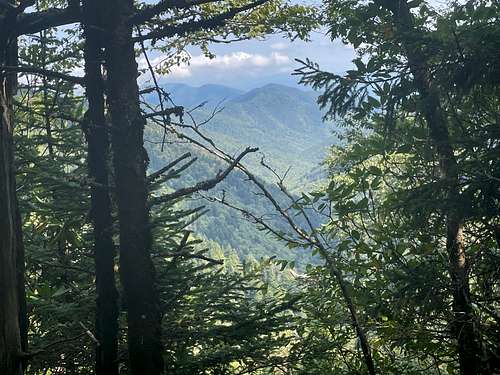
Simply put, outside of an impressive elevation for the eastern US, and a desire to check it off as part of a checklist, this mountain has little to offer hikers. There are no views from the mountain. It requires a long trail hike before a short bushwhack, with limited and mostly unimpressive views along the way.
Below is the best view of the day, where I went a little out of the way searching for a long range view.
Getting There
Getting where? There's many places to begin this hike. A few options are: (In parentheses is approximate shortest out and back from this trailhead)
- Snake Den Ridge Trail from Cosby Campground (19.5 miles) - Parking at 35.756964, -83.208085
- Balsam Mountain Trail (20 miles) - Parking at 35.633464, -83.178980 (Note this trail is on a one-way dirt road, be sure to approach it from the correct side or you may add a lot of driving).
- Benton Mackaye Trail (20.5 miles) - Parking at 35.623873, -83.211444 (This trail meets the Balsam Mountain Trail a few miles in)
- AT via Newfound Gap (32 miles) - Parking at 35.610144, -83.425649
There are several other opportunties around 20 or 30 miles round trip.
Route
As stated in the getting there section there are several trailheads this mountain can be hiked from. Though long, none are particularly difficult. If I was trying to make a decision on which way to tag this mountain my thought process for the decision is below:
Overall Easiest/Quickest
- Black Balsam Mountain Trail - Though not the shortest there is significantly less elevation gain than the shortest option and just barely longer.
Alternates if the access to the Black Balsam Mountain Trail (via the Black Balsam Mountain Rd.) is closed.
TN side
- Snake Den Ridge Trail. Much more elevation gain
NC Side
- Benton Mackaye Trail. Similar elevation gain, may add an extra 1/2 mile. Probably still easier than using the Snake Den Ridge Trail
Make it an overnighter
- AT via Newfound Gap. Longer, potentially better views. Two shelters along the way.
At the time of this writing detailed trail-maps are available on Great Smoky Mountains National Park Website. I'm not sharing a link, because I don't plan to maintain it.
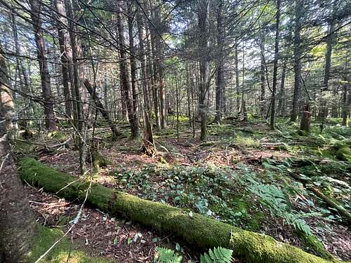
Once you choose your approach, to get to the top of Yonaguska you'll need to bushwhack a third of a mile or more (then bushwhack back to the trail). The bushwhack can reasonably be completed from the AT or the BMT. I think the easiest line begins from the AT, but very near the AT's junction with the BMT.
Wooded hiking during the bushwhack
Peak Lists (Tricorner vs. Yonaguska)
If familiar with peakbagging you will almost certainly already know that any peak on an elevation list will also need to meet a minimum requirement in prominence, this means two points with a high saddle between them will not both make the list.
Historically on elevation lists in the Southeast and North Carolina Tricorner has been listed and Yonaguska left off, this was still true as recently as around 2017 or 2018. Around this time many sites began acknowledging that Yonaguska was actually the higher of these two peaks on the same ridge. This means that Yonaguska has replaced Tricorner on these lists. Club lists and un-updated lists may still list Tricorner.
My experience agrees with the update. I feel pretty confident that after leaving the top of Tricorner I regained more elevation up Yonaguska than I lost between the two, but it is close.
Red Tape
Beginning in 2023 there is a parking fee to park anywhere in the Great Smokies for more than 15 minutes.
None that I know of for day-hikes. For camping I understand that camping is only allowed at official sites and reservations should be made. Tent camping is not allowed at sites with shelters. Some exceptions exist, particularly related to AT hikers.
When to Climb
Anytime.
Camping
See red tape. Review camping requirements at the Great Smoky Mountain National Park's website.
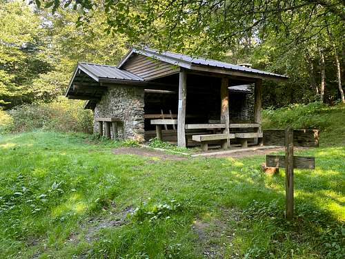
Below is an example of a shelter, Laurel Gap, of the Balsam Mountain Trail
Yonaguska (Drowning Bear)
The mountain was named after a later Cherokee Chief who fought to remain in the east despite pressures that moved much of the Cherokee and other natives west. Wiki Link