
|
|
Mountain/Rock |
|---|---|
|
|
48.77675°N / 121.81505°W |
|
|
Whatcom |
|
|
Hiking, Mountaineering, Trad Climbing, Ice Climbing, Mixed, Skiing |
|
|
Spring, Summer, Fall, Winter |
|
|
10778 ft / 3285 m |
|
|
Overview
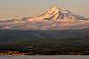
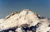
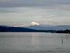
Mount Baker is a spectacular volcano in the North Cascades that offers excellent mountaineering to beginners and experts, alike. Baker tantalizes the residents of Seattle on clear days and stuns ferry passengers in the San Juan Islands. Located only 55 km inland from sea level at Bellingham, the volcano has dramatic relief.
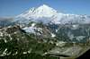
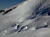
Mount Baker also achieves prominence as the 3rd highest summit in the State of Washington and the iciest mountain in the Cascade Range. More than 100 square kilometers of glaciers and permanent snow fields cover the mountain and are sustained by tremendous annual snowfalls; Baker received a world record of 28.9 meters over the winter of 1998-99! Consequently, crevasses are a major danger, dictating that all parties be proficient at glacier travel and rescue. Avalanche danger is commonly high because the notoriously variable weather can create unstable snow, even on moderate slopes.
Despite these risks, Mount Baker is an excellent first volcano for those learning to climb on snow and ice. When weather and glacial conditions are right, the ascents can be straightforward and relatively non-technical. Ice fills the summit crater, creating a broad, rounded summit that allows beginners to relax and enjoy the views.
The Coleman/Deming route is the most popular. The North Ridge is more difficult. The Easton route is the easiest, but it's approach can be less natural because it lies in the Mount Baker Recreational Area (where snow-mobile access is legal). The other routes fall within the (motorless) Mount Baker Wilderness.
 |
 |
 |
 |
 |
 |
Getting There
North Side Routes: This is the most common approach. Get on State Highway 542 heading east from Interstate 5 (I-5). A mile past the Glacier Public Service center turn right onto (poorly marked) Road 39. Note that this turn is easy to miss! After 8 miles the road will turn to gravel and soon after you will be at the trailhead. Until the snow melts in mid-June or so, drive in as far you can and then hike, snowshoe, or ski to the trailhead.
Easton Glacier Routes: (via the Baker Pass Trail) Get on State Highway 20 heading east from I-5 or west from State Highway 530. Go north on Baker Lake-Grandy Lake Road for 12 miles until the road splits. Here take Service Road 12 for 3 miles, and turn right onto Forest Service Road 13. Take this road for 4 miles until its end at Schreibers Meadow trailhead.
Ptarmigan Ridge Approach: From Bellingham, take State Highway 542 east from I-5 to its end at the trail head. Take the trail 5 miles to Camp Kiser. This approach is for the Park Glacier route, the Cockscomb, and the Roosevelt Headwall.
 |
 |
 |
 |
 |
Red Tape
Vehicles parked at all trail heads as well as some picnic areas and dispersed campsites within the Mount Baker-Snoqualmie National Forest require a Northwest forest pass which can be obtained from participating stores or ranger stations.
The Forest Service does not require permits for climbing Mt. Baker. It is strongly advised that all climbing parties register for their own protection. Registration is optional. It will, however, provide valuable information in case of emergency. Download the form (pdf) (doc) or pick one up at the ranger station. Then submit your completed form at the ranger station before attempting the climb. When your party returns, sign out at the station or call and let them know of your safe return. Failure to sign out may result in a needless and costly search effort.
Restrictions:
- Campfires prohibited on all climbing routes except parts of Boulder Glacier route. Self-contained stoves ok.
- Wilderness regulations apply within Mt. Baker Wilderness.
- Camping prohibited except in designated sites identified by constructed tent pads when camping below 6,000 feet within the National Recreation Area.
- A special-use authorization is required to conduct commercial activities or to provide any kind of service for instructing/guiding on Mt. Baker.
- Remove wands from your route and pack out all your garbage.
- Use mountain toilets when provided or the blue bag method; you can get bags at your ranger station.
 |
When To Climb
Summit attempts are made year round but the summer months (May-August) are much more popular and have better weather.
 |
 |
 |
 |
 |
Camping
NOTE: Party size limited to 12 members when entering the Mt. Baker Wilderness. Back-country permits are not required for climbs of Mount Baker.
Camping on the mountain is free (once you have the regional pass), but to learn about pay campsites in the park check with the Mount Baker Ranger District. If you climbing north side routes, a comfortable base camp (open mainly on weekends) is the Mount Baker Lodge run by the Mountaineers.
 |
 |
 |
 |
 |
Mountain Conditions
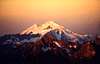
Baker gets loads of snow (average of ~50ft/year) and is white year-round due to its high elevation and geographic location (significantly west of the Cascades, breaking trail for the North Cascades through thick Pacific moisture). It is slowly becoming less glaciated, however.
Be aware that the weather is often bad. Exposure and low visibility can be the greatest challenges on the mountain.
In planning and timing your trip check winter road/trail, weather, and snow conditions. It may also be prudent to assess avalanche conditions (see section below on summer avalanche avoidance).
For a smooth approach check for trail information as well as helpful guidance regarding crevassed glaciers in the Mount Baker Climbing Notes.
After your visit, please call the Glacier Public Service Center at 360-599-2714 or Mt. Baker Ranger District at 360-856-5700 to give a conditions report, helping future climbers summit safely.
 |
 |
 |
 |
External Links to More Details:
- Forest Service guide to climbing Mt. Baker
- Geologic fact sheet
- Mountaineers pages (via: Coleman/Deming; Boulder glacier; Easton glacier; north ridge; Sherman Peak via Squak glacier).
- Mountain project page on Mt. Baker (has good relative ranking of route difficulties)
- Alltrails page on Mt. Baker "standard route" (often has recent trip reports)
Geological and Historical Notes
Mount Baker exhibited a small amount of volcanic activity in 1975-76 (steam release) and is expected to erupt again. Steam is often observed emanating from Sherman Crater, just south of the summit. Baker has a geologic history of frequent lahars (torrents of ash, rock, and water), the mountain's greatest geologic hazard.
Baker's summit, known as Grant Peak, is actually a volcanic crater that is ~1,300 feet deep and overflowing with ice. Younger, smaller Sherman Crater is partially ice-filled and its highpoint, Sherman Peak, is only elevation ~600 feet [200 meters] below the main summit. Two other prominent sub-summits are the Black Buttes -- Colfax Peak and Lincoln Peak. (Colfax was Grant's Vice President.)
Baker's proximity to the ocean has motivated a long history of races between the mountain and sea level. The contemporary version of this competition, the Ski to Sea, takes place over Memorial Day weekend (last Monday in May).
 |
Summer Avalanche Avoidance
Some notes to keep in mind during summer ascents when crevasses dominate the climber's mind (from the Northwest Weather and Avalanche Center):
"Because avalanches continue to occur at higher elevations during the summer months in areas having either residual snow cover or permanent snow and ice cover, and several people within the Northwest have been killed by these events, here are a few notes about summer avalanches.
Avalanches occurring during the summertime can be generally grouped into three types:
- First, wet slides within the existing snowpack are similar to wet spring slides, as progressive weakening occurs within the snowpack through melting and water percolation. Although these slides are most likely to occur during the warmest part of the day, they may occur at anytime of the day during periods when the snowpack does not re-freeze substantially at night.
- The second type of summer avalanche occurrence is associated with new snowfall at high elevations. Summer snowfalls are usually followed by substantial warming of the newly fallen snow as air temperatures rise rapidly with intense summer sunshine. When the new snow overlies an old snow, ice or smooth rock surface this may lead to possible wet loose or wet slab avalanches.
- The third type of summer avalanche is an ice or snow and ice avalanche. These are usually triggered by the failure of large ice blocks such as seracs within glacier icefalls. This in turn may involve additional ice and/or snow. Timing of these events are mostly random, usually being associated with both meteorological conditions and glacier motion. However, they are most likely to occur during extended periods of warm weather.
Climbers, hikers and other back-country travelers during the summer are advised to evaluate snow stability and use normal safety practices for travel in avalanche terrain with snow cover."
External Trip Reports
- North Ridge Trip Report, July 2001
- Coleman Headwall Trip Report, July 2000
- Easton Glacier summit ski trip report, August 1997
- Multiple ascents/attempts by Nate Riensche
- A 2003 climb of the North Ridge, inspired by CascadeClimber
kdpierson - May 13, 2003 10:58 pm - Hasn't voted
Untitled CommentJust came back from Baker yesterday- went up the Coleman route. Road 39 is still snowed in ~ 1/2 mile from the Heliotrope trailhead, but isn't that difficult to navigate. Slushy, sloppy snow continues along the duration of the trail to the timberline, and some of the snow bridges over streams are starting to melt out. Snow on Coleman is relatively soft w/ postholing up to upper elevations, making the lower part of the climb more of an effort.
kdpierson - Jun 9, 2003 10:25 am - Hasn't voted
Untitled CommentRoad 39 is completely clear to the trailhead and leathers can be used to reach the snowfield at ~5,000’. Please exercise caution crossing some of the swollen streams (nice warm weather over the past few days has heightened meltoff). We hit the lower glacier at 04:45 and it was way too late b/c the snow was nice and soft by the time we approached the ridgeline before Roman Headwall.. so we ended up sinking in quite a bit at 10,000’ for the final push. Some teams who left before us at 04:00 didn’t have as much difficulty- we saw them moving in the mountains’ shadow so the snow was still relatively firm for them, but teams behind us were having a great deal of fun with the postholing. Some snow bridges are starting to open up on the glacier, but not that badly yet.
Please also watch out for the avalanche zone the trail navigates through in the morning- we saw three on our way up when the snow was hitting the seracs.
Derek Franzen - May 16, 2005 3:49 pm - Voted 10/10
Untitled CommentThe Golden Passport will be honored at all Northwest Forest Pass Fee Sites according to the USDA FS website.
rgb2 - Sep 3, 2009 3:02 am - Voted 7/10
2009 seasonRoad 39 is not driveable. Forest recreation annual pass is $50. Some links on this page are no longer valid. Please check US Forest Service website for up to date conditions. If you summit Baker please send your report to Forest Service. http://www.fs.fed.us/r6/mbs/conditions/road-trail-conditions.shtml
scottv - Apr 2, 2021 11:01 pm - Hasn't voted
Re: reporting conditionsGood idea to encourage sharing a report with the FS after a climb! I've added updated contact info for all routes...
Springthyme - Jun 22, 2021 9:28 am - Hasn't voted
Missing Ice AxeTo anyone you might have shared the mountain with me on Monday June 21st. My green BD axe with a 48in runner came detached from my pack on the plateau before the summit. Conditions: hike 2 miles on the heliotrope trail before you his snow. A little crusty snow until the sun hit for some amazing corn for ski descending!