
-
 290213 Hits
-
 70.34% Score
-
 7 Votes
|
|
Mountain/Rock |
|---|---|
|
|
35.88034°N / 76.51246°E |
|
|
28250 ft / 8611 m |
|
|
OVERVIEW
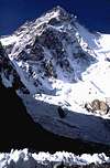
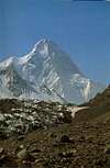
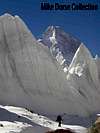
Reinhold Messner called K-2 the "Mountain of Mountains" after his ascent of K-2 in 1979. This pyramid of a mountain is right in the heart of the Karakoram Range and can be seen in its entirety from Concordia. It is at the head of the Godwin Austin Glacier which unites with a second glacier at Concordia to form the famous Baltoro Glacier. Four 8000m peaks sit within a radius of 13 miles from Concordia, making this the largest concentration of the highest peaks anywhere on earth.
Unlike Everest, the world's second highest peak does not have a monsoon season, so most climbs are in July and August, a time of year when the weather is best. First discovered by westerners during the survey of India in 1856 by T.G. Montgomerie. Mongomerie assigned eack peak he discovered with a K for Karakoram and then a number. Most peaks, however were named by the local people. Since most of the locals had never seen K-2 it escaped this fate. It was temporarily named Godwin Austin by the British, but it was eventually dropped and K-2 stuck.
K-2 is located on the border between China and Pakistan. It is said to be the ultimate climb, since many consider it to be much more technically challenging than Mount Everest. Many people try to climb K2, and many have died trying. a bit over 300 people have made the summit. For about every 4 that summit one is killed in the attempt. The route through the Abruzzi Spur and up the Black Pyramid is said to be slightly "easier" climbing, more so than the North Ridge route. Eza adds the follwing information: The first climb to K2 was made by the Italian team led by Ardito Desio. The first climbers on top were Achille Compagnoni and Lino Lacedelli. Nevertheless, there were some earlier expeditions that made the first reconnaissances of the Abruzzi Spur: the Duke of Abruzzi in 1909 and the American teams led by C.Houston in 1938 and 1953.
jck adds: Many climbers consider K2 as the most difficult one of all 8000 meter peaks.
K2 has four major ridges, and two smaller ridges:
south-east:The Abruzzi Spur
south-west:to Negrotto Pass and Angel Peak
north-east:to Juncton Peak
north-west:to Savoia Pass
K2's north face towering over the Glacier K2 is one of the biggest walls on the world.The right side of the wall is enormous north pillar.Over the Godwin Austen Glacier rises beautiful east wall.In 2/3rd of the wall there's a big icy terrace called K2's Arm. West pillar divides west wall into two parts:one over the Negrotto Glacier and the main part over upper part of Savoia Glacier.On that part is big,over 1000 meters high,rocky part called "Barrel".On the south face there are two spurs: right one which reaches The Abruzzi Spur at the height of Arm and left which combines with south west pillar over the hanging glacier de Filippi.
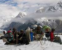
If you are planning on climbing K-2 you may be part of an expedition in which case preparations and logistics will be a part of the expedition. For this page, I am going to assume you are more interested in doing a trek to Concordia or K-2 Base camp, as this is a much more likely event. Should you decide to try to summit, you will be part of a well organized group of climbers or be escorted by a touring company.
 |
 |
 |
 |
 |
GETTING THERE
Everything in Pakistan starts from the capitol of Islamabad. There are numerous hotels to stay at in Islamabad, but a couple used by climbers are the Envoy, Shalimar and Royal Inn. You will need to get trekking permits there. Then off to Skardu by plane if weather is good, or by the famous Karakoram highway ( the old silk route) if weather is bad. Hotels are a bit more scarce in Skardu, but the Skardu Shangri La resort, and Masherbrum Hotel are also frequently used by climbers enroute. If you fly to Skardu you will also see the 9th highest mountain in the world- Nanga Parabat. If you go by land - it is a 2 day trip with a stopover usually near Gilgit ( the romantic area thought of as Shangri La and near Hunza- the people noted for living longer than any others in the world). Be prepared for delays here as this is a rather primitive area. This is one trip where I would feel more comfortable as part of a larger group, as stories of robbery abound all along this notorious highway.
Skardu is the gateway to the high peaks of northern Pakistan and will serve as a base of operations. From Skardu you will need to jeep as far as possible towards Askolie, the last village before reaching K-2. Beyond Askolie is complete wilderness and glaciers. From Askolie the normal route will take about 2-3 days to the Paiyu campsite (3666m) near the base of Paiyu Peak (6660m). The next day the trek is usually to Urdukas to cross Baltoro Glacier. Then next day trek to Gore, which is about an 8 hour trek. Then another 5 hour trek to Concordia. It is usually a 4-5 day trek to reach Concordia. Finally, trek to Broad Peak Base Camp and trek to K-2 Base Camp.
 |
 |
 |
 |
 |
ROUTES
The Pakistan side
The most popular, and generally considered one of the most dangerous routes, is the Abruzzi Spur. This is most likely the route you will take. Most likely considered the most dangerous because it is the most climbed.
Other less popular routes from the Pakistani side include the NE Ridge, South/Southeast Spur, SW Pillar or "Magic Line" (a route Reinhold Messner once called suicidal), South Face, and the Polish Route, a route known for avalanches.
The Abruzzi Spur
(South East Ridge)
This is the closest to a "normal" route on K2, but is still very difficult and dangerous. The route starts on loose scree for about 3000 feet to camp 1. Camp 1 at about 21,000 feet is exposed but relatively secure, with little or no history of avalanche danger.
The climb to Camp 2 includes a 50-meter off-width crack called House’s Chimney which is currently a spider’s web of old ropes. Camp 2 is sheltered by a large rock, but can get extremely windy and cold.
Camp 2 to Camp 3 is the most technical section of the climb, with approximately 400 meters of vertical and near-vertical climbing on mixed rock and ice in a region known as the Black Pyramid. House's Chimney,Black Pyramid and Bottleneck are the most noted aspects of this route.
Camp 3 is at about 23,500 feet and is very suseptible to avalanches. The climb to camp 4 is a long snow slog typically accomplished without fixed lines. Best to travel fast as possible in this area as sections have been known to collapse along the shoulder.
Camp 4 at about 25,000 is still more than 1/2 a day (most likely closer to a full day) from the summit.
The Summit 28250 feet
Most climbers leave between 10 p.m and 1 a.m. for the summit. Consider bringing a thin line (4-5mm) for the Bottleneck, a 100-meter narrow couloir at 8300 meters that is 80-90 degrees. If it is windswept and cold, the ice in this couloir can create extremely challenging, sustained climbing. At least 10 of the climbers who have died on K2 lost their lives in the Bottleneck.
From the Chinese side there are two main routes: The North Ridge and the Northwest Face. These routes are seldom climbed relative to those from the Pakistan side.
PERMITS AND FEES
There is a lot of red tape in getting permits and paying fees. This is normally handled by your tour operator.You will need to spend some time in Islamabad at the start of your trek to get your trekking permit. I would recommend being part of a group on this trek as weather and remoteness present conditions where support is crucial.
As of 2013 climbing permits cost $7200 for up to 7 climbers and are $1,700 for each additional member. In addition to the peak fee, you will need to put up a $6,000 rescue bond (refundable), and a $200 environmental fee. You will be required to travel with a Pakistani Army Liaison Officer, and will also be responsible for his fee, equipment, and expenses. All Permits must be secured by November of the previous year.
ROYALTY FEES 2013
Following are royalty rates for scaling peaks of various height in Pakistan:
Height of Peaks Royalty in US$ (1-7) for each additional member exceeding 7 per team an additional fee at the Following rate will be charged.
1 K-2 8611m 12,000 $ 3,000
2 8001-8500m 9,000 $ 3,000
3 7501-8000m 4,000 $ 1,000
4 7001-7500m 2,500 $ 500
5 6000-7000m 1,500 $ 300
(These rated are subject to periodic revision). Additional fee will be charged it the number of party is for more than one peak the additional number is to pay for the other peak also.
Costs for porters, guides, permits and fees are subject to change. Check with your tour operator for latest pricing. As a guide, for a group of 7 team members in 2013 consider about $3000-$4000 per person for a trek to base camp, and about $8000-$10,000 for a climb. These amounts will of course vary, based on the number in your group and the inclination of the government.
 |
 |
 |
 |
 |
LIASON OFFICER AND PORTER DETAILS
The Ministry of Tourism has strict guideleines to outline the duties, costs, kits, equipment etc. of the Liason Officer and the porters. As of 2013 here are the most important:
LIAISON OFFICER (L.O)
A party shall include in the expedition, as its member at least one L.O. to be detailed by the Government of Pakistan.
A party shall pay for his food; accommodation and transport for mountains and back from reporting date of the expedition in Islamabad till the date the party is debriefed.
During the stay of a party at Rawalpindi / Islamabad the L.O will be given daily allowance at the rate US $ 30/- per day. The L.O. in a city of Northern Areas (such as Skardu, Gilgit etc.) is to paid US $ 15/- per day and accommodation.
A L.O shall carry his personal equipment like any other member of the party.
A L.O. shall be consulted on routes and local customs and if desired on matters such as transport accommodation and rations. If however, a leader disagrees with L.O. he shall give him in writing the reasons for such disagreement.
A L.O. shall extend maximum assistance to a party in making purchases etc. He shall, however, not handle any cash nor undertake any financial transactions on behalf of a leader/party.
KIT & EQUIPMENT
For Liaison Officer
A L.O shall accompany a party to a maximum height with the consent of the leader or atleast stay at the base camp till the party descends and return with the party for debriefing at Islamabad. For this purpose a party shall provide him, free of cost necessary kit and equipment in order to enable him to perform his duties without any risk to his person.
Kit / equipment for L.O. should be brought to his measurements sent to a party in advance. If a party does not receive measurement before its departure for Pakistan it may bring standard size kit and equipment. Shirt and Jean trousers may be purchased in Pakistan to avoid size problems.
For Low Altitude Porters
A low altitude porter shall accompany a party upto the base camp (Maximum height 5,500 meters). For this purpose a party shall provide him with standard kit/equipment free of cost.
In case a low altitude porter is desired by the party to go above 5,500 meters (except passes enroute) he shall be entitled to kit / equipment and ration as prescribed for high altitude porters.
WAGES OF PORTERS
A rough idea on wages and charges for animal and mechanical transport will be communicated to the party along with the formal permission letter.
Payment of wages to porters shall be made when they are discharged. However , if a porter required an advance payment ,this may be given in the presence of L.O./Guide and receipt obtained.
In addition to daily wages, a party shall provide to a low altitude porter free ration as per Annexure-G or money in lieu of rations ,as fixed by the Government from the day he is engaged till the day he is discharged.
Similarly free ration shall be provided to high altitude porter from the day he goes above 5,500 meters.
Except in the case of sickness/injury no wages shall be paid to a porter for a day on which he does not work. If however , a party wants to have a rest day then porter(s) shall be paid full wages etc.
For forced halt on bad weather days a party shall pay t porter full daily wages and rations. Decision of a leader about movement on such days shall be final. If however. L.O. feels that the weather is too bad to march. He may ask the leader to halt the party. In case of disagreement with the advice of .L.O. the leader should give in writing the reason for such disagreement.
A porter marching with a party for more than seven day shall be allowed every seventh day as holiday with full daily wages etc.
The cook will be provided the kit/equipment (except climbing tools) of a high altitude porter.
For High Altitude Porter
A party shall arrange to provide, free of cost, standard kit and to a high altitude porter in order to enable him to perform his duties.
WHEN TO CLIMB
June through September are prime times to make this trek. Allow at least 3 weeks to do the trek described here. But in remote places such as this its always a good idea to be flexible and allow several extra days for unforeseen situations.
 |
 |
 |
 |
 |
SCENERY
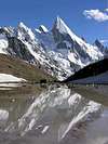
This has got to be one of the most beautiful mountain areas in the world. Not only are there high mountains, but also spectacular views of some of the best vertical needles in the world. The trek on the Baltoro Glacier provides awesome mountain scenery of Masherbrum (7750m),Uli Biaho Tower (6190m), Trango Towers (6300m) Grand Cathedral (5228m) and Mustagh Tower (7284). From Concordia you can see K-2 as well as Broad Peak (8044m), Gasherbrum Group, Golden Throne (7365m) and Chogolisa (7686m).
 |
 |
 |
 |
 |
A BIT OF K-2 HISTORY
The first attempt to climb K-2 was in 1902 by Oscar Eckenstein, a British chemist and engineer who is credited with inventing the crampon. His summit attempt along the northeast ridge stalled at 20,000. This route was not attempted again for seventy-four years.
In 1909 the Duke of Abruzzi, the noted Italian, attempted the climb via the southeast but made it only to 19,600 feet. This route, latter called the Abruzzi Spur, is the route that latter led to the first summit of K-2.
In 1938 the Charles Houston led team made it to 25,000 on the Abruzzi Spur Route. Weather and a lack of adequate supplies forced to the expedition to end.
A year later in 1939, Fritz Weissner got to within 750 vertical feet of the summit. But his sherpa, afraid of making the summit after dark, was afraid the spirits would kill them and again, forced a retreat.
In 1953 Charles Houston tried again. After making the climb to 25,600 things went from bad to worse. While waiting for a break in the terrible weather, one of the team, Art Gilkey, suffered from blood clots in his leg.
As the team began to retreat and began lowering Gilkey by ropes, one member of the team slipped and pulled down 4 others with him. Pete Schoening had been belaying them, and his ice axe, buried behind a rock, was the only thing that saved them all from a sure death. As the team finally tried to settle in to bivouac Gilkey was left unattended and was swept off the mountain in an avalanche. His remains were not found for 40 years.
In 1954 K-2 was finally summited by the Italian team of Achille Compagnoni and Lino Lacedelli by way of the Abruzzi Spur.
The first summit by an American team did not come until 1977 when a team consisting of Jim Wickwire, Rick Ridgeway, John Roskelly, and Lou Reichardt made the summit by climbing the northeast ridge, and then traversing to the Abruzzi Spur for the last 3000 feet. Ridgeway and roskelly made the ascent without oxygen.
The first British ascent was in 1986, a brutal year on the mountain. Alan Rouse and Julie Tullis made the ascent, but died on the descent. Twenty seven made the summit in 1986, but 13 people died trying.
Courtesy of Marco979
In 1954, an Italian expedition came to Pakistan to try its luck on K2. It consisted of twelve climbers and four scientists and was led by veteran mountaineer, Professor Ardito Desio, who had come to these mountains with Italian expeditions before the World War II. Colonel M. Ataullah and Arshad Munir accompanied the expedition from Karakoram Club of Pakistan. Captain (later Lt. General) G.S. Butt was the liaison officer.
Poor weather hindered the progress of the party for a pretty long time. As soon as the weather cleared, the party made very good progress and set up camp II. It was at this camp that one of its members, Mario Puchoz, a 36-year old guide, died of pneumonia on the 21st June. It Is believed that he had contracted high altitude pulmonary edema (water on the lungs) which was not well known at the time and does not respond to antibiotics.
The party established six more camps on the south-east ridge. Camp IX was a bivouac. On the 31st of July, Lino Lacedelli and Achille Compagnoni started from the bivouac. They exhausted their oxygen supply 500 feet short of summit but could not resist the temptation to be the first to climb the mighty K2 peak. They, therefore, continued their assault and reached the summit at six in the evening. After staying for a while they started descending and reached Camp VIII round about eleven at night.
Courtesy of jck : In 1978 Americans Louis Riechartd and James Wickwire ascended new route on the north-east ridge.
In 1981 Eiho Ohtani and Nazir Sabir climbed the west pillar.In upper part they traversed to south pillar and reached the summit.
The first ascent from north side(by enourmous north pillar) was made in 1982 by Japanese expedition.
And the came the tragic year 1986: 27 climbers reached the summit but 13 died.Wanda Rutkiewicz reached the top as the first woman.She climbed the normal route via Abruzzi Spur.Jerzy Kukuczka and Tadeusz Piotrowski,Polish climbers,members of international expedition which was leading by Karl Maria Herrligkoffer climbed the central part of south wall.Unfortunately Piotrowski died during descent.
Also in 1986 two Poles Wojciech Wroz,Przemyslaw Piasecki and Slovak Peter Bozik reached the top via south pillar which Reinhold Messner called "Magic line".
There was also two winter attempts, both made by Polish expeditions in 1987/88 and in 2003 but they were unsuccesful due to bad weather. Krzysztof Wielicki,the fifth man who reached all 14 8000 meters peak and who was a member of both winter expeditions said that problably in 2005 or 2006 they will try again to reach the summit during the winter season.
More recently, in 2008, a group of climbers went missing during an avalanche that took out the fixed ropes on part of the route. Eleven climbers, including Gerard McDonnell, the first Irish person to reach the summit, were confirmed dead.
In 2010, Fredrik Ericsson fell 1,000 meters (3,300 ft) and was killed.
2011 was a historic year on K-2. A team of four climbers reached the summit of K2 from the Chinese side. Gerlinde Kaltenbrunner became the first woman to complete all 14 eight-thousanders without supplemental oxygen.
In 2012 the year started with a Russian team trying for the first winter ascent. The expedition failed on an unfortunate note with the death of Vitaly Gorelik due to frostbite and pneumonia. That summer K2 had 28 people summit in a single day, bringing the total to 30 for the year.
 |
 |
 |
 |
 |
GIVING BACK
I have had the pleasure to meet two of the directors of this non profit organization and would encourage your support for their activities to help the people who live in remote regions of the world.
The Alex Lowe Charitable Foundation- provides direction and financial support to community based humanitarian programs around the world. Currently the foundation is involved in establishing a climbing school for Sherpas as well as the Babu Chirri School Project to build schools in the Khumbu region where Babu was from. The organization is also active in promoting climbing safety and technique in Mongolia. There is very little over head in this operation, and a very high percentage of donations go directly to benefit the projects.
Alex Lowe Charitable Foundation
PO Box 6666
Bozeman, MT USA 59715
The Alex Lowe Charitable Foundation
 |
 |
 |
ITINERARY INFORMATION FROM LOCAL TOUR OPERATORS
Karrar Haidri adds:
K-2 Concordia Ghondhgoro la, K-2 Base camp treks offers some of the most challenging, remotest and demanding trekking anywhere in the world. Trekking in this area is a wonderful experience for any one who enjoys the world most spectacular and diverse scenery of snow capped lofty mountains, lush valleys, chuckling streams and emerald green lakes, atypical wildlife like the Snow Leopard and the Ibex and colourful ancient culture and its friendly people leave an everlasting impression on the visitors. This is a typical trekking itinerary. Costs as of May 2013 run about $3000- $4000 per person.
K2 Ghondogoro La Trek
DAY 01 ARRIVAL RAWALPINDI
Arrival met and transfer to your hotel. After a short rest drive to Islamabad for trek briefing at Ministry of Tourism and obtain trekking permit. Overnight hotel.
DAY 02 RAWALPINDI/SKARDU
Flight to Skardu, If unable to fly, same day departure for Chilas via Silk Rout, sight seeing all along the rout with the company of Indus river the longest river of Pakistan It flows from Tibet northwest across the Indian-controlled portion of Jammu and Kashmir, passing between the western extremity of the Himalayas and the northern extremity of the Hindu Kush mountain range; it then courses generally south through Pakistan to the Arabian Sea.
Check in hotel. Overnight in Chilas.
DAY 03 CHILAS/SKARDU
Arrival in Skardu.
Total drive time from Islamabad to Skardu is 22-24 hours.
DAY 04 SKARDU
Free day for rest, shopping or sightseeing. while staff will make final arrangement for the trek.
Overnight at hotel. Breakfast, Lunch & Dinner included.
DAY 05 SKARDU -TO- ASKOLE
Embark jeeps for a full day ride on a winding jeep trail to Askole. The last inhabitance on our way to the Great Glaciers. Highest in the region, the stone & timber abodes contain dark & narrow stairwells riven by gloomy, unlit alleys cluster within the embrace of the fertile terraces. Overnight in tents.
Distance 96 km
Drive 07-08 hrs
Altitude 3050 m
DAY 06 ASKOLE -TO- KOROPHONE
Today we leave the last inhabited village. For the remaining portion of our journey we rely on our porters who carry our food and equipment's and sustain our expedition. After scrambling over a ridge we come across what legend says an old polo field. Passing through a rock gap we cross the Biafo glacier and camp beside its snout at korophone. The Biafo Glacier is a huge river of ice 63 Km long which descends from the central peaks of the Karakoram & flows East into the Braldu Valley at a point about 10 Kms east of Askole. Overnight in tents.
Walk : 03 - 04 hrs
Grade : Easy
Altitude : 3100 M
DAY 07 KOROPHONE -TO- JHULA
Trek to the Dumurdo river cross at Jhula., now a wooden bridge is made cross it & camp beside a torrent facing the Bakhordas.
Walk : 03-04 hrs
Grade : Strenuous
Altitude : 3150 M
DAY 08 JHULA -TO- PAIJU
Resume trek along the Braldu River to a green Oasis under the shadows of Paiju Peak 6611 M. Paiju - is a Balti word which means "SALT". Since there are some rock salt deposits at the base of this peak, the locals believe that the snow on the summit of Paiju Peak is not snow but a huge deposit of salt which drips down to the base. From this camp we have the first view of the impressive Baltoro Glacier. Overnight in tents.
Walk : 05-06 hrs
Grade : Moderate
Altitude : 3480 M.
DAY 09 PAIJU - Rest Day
Rest & acclimatization day at Paiju. Overnight in tents.
DAY 10 PAIJU -TO- URDUKAS
Begin trek after an early breakfast. Traverse the junction of Paiju - Baltoro Glaciers through crevasses & lunch below Liligo, the traditional camp under the muddy cliffs with fine views of rock spires. Cross the Khuburse torrent early morning and ramble over two glacier moraines to reach the grassy slopes of Urdukas offering splendid views of the Trango, Uli Biaho & Bial Groups. Overnight in tents. All meals served by camp staff.
Walk : 06-07 hrs
Grade : Moderate
Altitude : 4130 M
DAY 11 URDUKAS -TO- GORO
A long walk on the icy Baltoro Glacier. Traverse the Yermanandu Glacier which flows down from Masherbrum & joins the Baltoro. Magnificent views of Muztagh, Mitre & Gasherbrum IV. Overnight in tents.
Walk : 06-07 hrs
Grade : Strenuous
Altitude : 4500 M.
DAY 12 GORO TO CONCORDIA
After an early breakfast, resume a long walk on the Baltoro Glacier to a point called Concordia - a huge junction of Baltoro, Abruzzi & Godwin Austin Glaciers at 4000 meters . Within a short radius of 15 Kilometers, stand 41 peaks over 6500 meters. including 04 peaks above 8000 M. The 360 view offers a panorama of peaks nowhere to be found on this Earth. Overnight in tents. All meals served by camp staff.
Walk : 05 - 06 hrs
Grade : strenuous
Altitude : 4720 M.
DAY 13 CONCORDIA REST DAY
Members are free to explore K2 base (A day trip 4 hrs up 3 hrs down) After an early breakfast, resume your walk to K2 Base Camp. Overnight in tents at Concordia.
Walk : 07 hrs
Grade : strenuous
Altitude : 4650 M.
DAY 14 CONCORDIA -TO- ALI CAMP
After an early breakfast leave the Concordia and we will cross several side glacier to reach our right path. After 2 hours we will reach Vigne glacier, it is also possible to walk on the Vigne glacier which is fairly easy then walking on the stony bath on the right side of the glacier but it depend on the snow condition.
Overnight in tents.
DAY 15 ALI CAMP -CROSS GONDOGORO PASS- KHUSPANG
A very early start as early as 2 or 3 O'clock in the morning to cross the Gondogoro la to reach Khuspang. The basic theme behind the early walk to reach the top of the Gondogoro Pass 5700 metres is that in the morning snow will be soft and you will not get tired quickly as the sun is not strong, but as sun get strong snow get soft, snow going to be melt and bring water and stones, also the chance of ice falls or avalanches. Overnight in tents. All meals served by camp staff.
Walk : 10 - 11 hrs
Grade : Strenuous
Altitude : 5700 M
DAY 16 KHUSPANG
Rest day at Khuspang.
DAY 17 KHUSPANG -TO- DALSANGPA
After a couple of minutes of easy walk we will comes onto the glacier. You pick your way across moving boulders and ice, finally crossing the glacier up to the camping site to reach Dalsangpa, meaning 'field of flowers', lives up to its name. It is a beautiful campsite at about 4,150 metres, set between two lakes, with Masherbrum Mountain and the white glacier cascading down from Masherbrum Pass reflected in the still water.
Walk : 05-06 hrs
Grade : Moderate
Altitude : 4150 M.
DAY 18 DALSANGPA -TO- SHAICHO
Resume trek along the path, Keep yourself on the left side of the lateral moraine, crossing several side streams. The next hour is an unpleasant scramble along the stony, sliding glacier edge, with huge boulders poised above, ready to fall.
Continue your trek along the path goes down hill to the summer settlement called Shaicho, a large shepherds settlement with its won mosque, now here you can find a hotel and mountaineering equipment shop. This is the traditional camp among the forest of juniper, cedar and willow trees with giant bushes of wild roses and a good water supply. After a short break continue your walk along the Hushey river on a easy path. Upon arrival camp near the fields in Hushey village. Overnight in tents.
Walk : 06 - 07 hrs,
Grade : Easy
DAY 19 SHAICHO -TO- HUSHEY
An easy day will bring you to Hushey village. Evening free. Overnight in tents.
DAY 20 HUSHEY -TO- SKARDU
AM : Embark jeeps for a full day ride on a winding jeep trail to Skardu. Upon arrival transfer to hotel.
DAY 21 SKARDU - RAWALPINIDI
Early in the morning fly to Islamabad, if unable to fly same day drive to Gilgit. Overnight in hotel.
DAY 22 RAWALPINDI
Upon arrival transfer to your hotel in Rawalpindi. Evening sightseeing.
If unable to fly on day 25th. this day will be use to transfer from Gilgit to Islamabad by road.
DAY 23 RAWALPINDI
De-briefing at Ministry of Tourism Islamabad. Evening transfer to airport for your onward destination.
Aaporik adds:
From Skardu most of the expedition trek to K2 base camp via Baltoro. Very few expedition takes the Gondogoro La 5800m to reach K2 Base camp. Although most of the expedition use Gondogoro la for their way back to Skardu.
After arriving in Skardu you take a jeep 8 hours to Hushe village. From Hushe the trekking path will bring you to Khuspang in 3 days via traditional camps of Siacho, Gondogoro Broq, Dalsangpa. Another three days will bring you to K2 base camp via Gondogoro pass, Ali Camp, Concordia.
WOMEN OF K-2
First 11 women to have summited on K2:
1 Polish climber Wanda Rutkiewicz 1986
2 French climber Liliane Barrard 1986
3 British climber Julie Tullis 1986
4 French alpinist Chantal Mauduit
5 British climber and mother Alison Hargreaves
6 Edurne Pasaban from Spain.
7 Nives Meroi from Italy.
Nives had attempted K2 twice (1994 and 2003 through the north side). She typically travels light, without oxygen or high-altitude porters.
8 Japanese first female K2 Climber Yuka Komatsu,reached the summit on August 1 2006.
9 Oh Eun-Sun South Korea 20 July 2007 SE Ridge (Abruzzi Spur)
10 Cecilie Skog Norway 5 pm, 1 August 2008 SE Ridge (Abruzzi Spur)
11 Go Mi-Sun (Mi-Young) South Korea 5:30 pm, 1 August 2008 SE Ridge (Abruzzi Spur)
In 1986 Polish climber Wanda Rutkiewicz became the first women ever to reach the top of K2 and was followed to the summit that same year by French climber Liliane Barrard and British climber Julie Tullis, both of whom died on their descent. Then in 1992, the summer that Wanda Rutkiewicz perished on Kangchenjunga, French alpinist Chantal Mauduit summitted K2, and survived, only to die six years later on another 8000 meter peak.In 1995 British climber and mother Alison Hargreaves reached the top but was killed shortly after starting her descent.
Edurne Pasaban from Spain has summited K2 on 26 July 2004 at 16.30. Edurne Pasabán (30) was born in Tolosa (Basque Country, Spain). She has also climbed more 8000+ peaks than any other living female. She has bagged Everest, Lhotse, Makalu, Cho Oyu, GI, GII and K2 Nanga Parbat in just a few years.
Nives Meroi and husband Romano Benet K2 26th July 2006 at 10-30 am local time. The two climbers left on their summit push at 2:00 am that morning.
Nives has thus bagged her 8th 8000er. The couple has also achieved the first summits on K2 since 2004.
Nives Meroi was born in Bergamo in September, 1961. She has previously summited Nanga Parbat, Cho Oyu, GII, GI, Broad Peak, Lhotse, Dhaulagiri, and now K2. She also has reached Shisha Pangma’s Central Summit. Nives had attempted K2 twice (1994 and 2003through the north side) and Everest in 1999. She typically travels light, without oxygen or high-altitude porters.
Japanese first female K2 Climber Yuka Komatsu (23), and Tatsuya Aoki (21),reached the summit on August 1, at 4:50 pm, local time. Yuka has become the first Japanese lady climber to summit K2, and Tatsuya is now the youngest K2 summiteer ever.
.
PET PEAVE- LEAVE NO TRACE
In America, as in many other countries, I imagine, there is a philosophy of leave no trace. In other words, leave the place you hike the way you found it. It bothers me when the same people who will leave no trace in their own backyard do not do the same when they are a guest in another country because it just might be too difficult. Please take heed to the following post by Karrar Haidri and do your part to make mountain regions better, not worse, then how you found them.
From Karrar Haidri:
Visiting mountaineering expeditions and trekking parties accompanied
by large number of local porters on the Baltoro glacier, especially
during previous and current year has resulted in large accumulation
of waste in the various camping areas on the glacier. The returning
visitors to the area are reporting increased deposits of garbage and
human body waste lying on these glacier camps, which besides
seriously damaging the local ecology, are becoming a hazard to the
visitors health. As the climbing and trekking season is nearly ending
there is an urgent need to undertake clean up operation to clean and
carry back the garbage out of the area before the onset of fresh snow
which may shroud the pollutants. It may be mentioned that 62 KM long
Baltoro glacier is the jewel of Karakoram situated about 120 KM
Northeast of Skardu which houses four peaks rising above 8000 metres
including K2, Broad Peak, Gasherbrums and many other high and
challenging peaks. The area is frequented by large number of
mountaineers and trekkers each year and during the current year over
50 mountaineering expeditions and about 2400 trekkers have visited
the Baltoro glacier till date.
In view of the urgency of the situation Alpine Club of Pakistan is
launching Baltoro Clean Up Expedition 2005 to Baltoro glacier
commencing from 10 Sep 05. The expedition which is expected to last
till first week of Oct 05 will undertake clean up of camps on the
Baltoro glacier including main Base camps of K2, Broad Peak and
Gasherbrums. The team employing local porters will collect all
burnable and non burnable garbage to include packing tins, cartons,
polythene bags, food stuff etc and carry it out of the area for its
correct disposal below Askole – the last village enroute to Baltoro
glacier.
The expedition is being led by Mr MH Muzzaffar Faizi ACP Executive
Council member whereas its other members include Mr Wazir Jaffar
Shigri - ACP Representative at Skardu and Nisar Hussain.
The expedition is being financed by ACP from its own financial
resources, whereas Ministry of Tourism has promised to contribute
towards funding of this clean up effort – an important matter
affecting mountain tourism in the Northern Areas.
It is to be mentioned here that similar cleaning expeditions have
been organized by the Alpine Club and other NGOs in the past.
For more detail visit
http://www.k2climb.net/news.php?id=717
MISCELLANEOUS INFORMATION
The main thing to think about before any attempt on K-2 is obviously am I "qualified" to attempt this mountain. Long after the glamour and mystique of this mountain are gone, and you find yourself facing the vertical limit with snow blowing in your face, your legs wobbling and your body shaking from cold... is not the time to be asking yourself that question. If you are trekking to K-2 it is going to be a strenuous trip... be prepared.
EXTERNAL LINKS
- treks, tours , expeditions
Ishaq Ali
Managing Director
< - climbing and trekking services for K2 area
This company with long experience in climbing services in Xinjiang can organize various packages for climbing and trekking in K2 area from the China side. - www.jasminetours.com/k2mt.html
We are organizing fixed departure for K2 8611m for 2006 season and also supporting trek to K2 Base camp via the normal route or over the Gondogoro Pass. - http://www.saltorosummits.com/mountaineering.php
We are confident in our abilities to provide our outstanding services in the heartland of greatest assembly of mountains that stand on this earth.
fabrizior - Jan 27, 2004 11:15 am - Hasn't voted
Untitled CommentThe official (Ardito Desio) report of the Compagnoni/Lacedelli climb stated that the team had to climb the last part of the route without the Oxygen.
This has been demonstrated completely false because the pics on the summit are confirming they used oxygen up to the summit(masks and bottles).
Also the timing can support the availability of the oxygen up to the time they reached the summit.
This is a sad history that should (must) be re-written by Club Alpino Italiano admitting the truth on the great contribution of Walter Bonatti (accused playing dirthy tricks and using the oxygen reserved to the top team) for the conquest of K2.
CharlesD - Jan 6, 2005 1:57 pm - Hasn't voted
Untitled CommentWalter Bonati offers a fascinatingly, disturbingly different version of the final few days of the Italian K2 expedition in 1954. This version, long discreditted, is now given more credence thanks to recently discovered photos and Bonati's long-held physiological arguments. There is strong evidence that, among other things, the summit team did not run out of oxygen on the final summit bid. Readers are referred to a detailed discussion in Walter Bonati's "Mountains of My Life" referenced in the books section of this peak.
signorellil - Jan 8, 2005 5:37 am - Hasn't voted
Untitled CommentWait a minute - NOTHING has been demonstrated about the use of oxygen. The only fact generally accepted is that, in all probability, the location of the last camp was different in respect to the "official" location (the one you see in the maps), and thus Bonatti could not have reached the camp for the night in any case (if this was done deliberately, it's another thing).And Compagnoni's behavior towards Bonatti was decidedly unfair, but that's another thing.
The pics shows only that they arrived to the summit with their masks stiill attached to the gas bottles, nothing else. This could have been amply justified by the need to protect the mouth from the cold. Also, it's demonstrated that Compagnoni and Lacedelli arrived to the summit in - let's say - an very depleted psychological state, so it's difficult to explain their actions in normal rational terms. Lacedelli, in his recent memory book, has - in my view - very clearly re-affirmed that the oxygen finished 200-300 meteres below the summit.
I don't think Bonatti used the top team oxygen for the simple reason that (as everyone knows) the oxygen was mainly useless, because of it's gas mix was wrong (only four bottles were used in the entire expedition). Prolonged use would have caused chest pains, etc.
Bonatti's smear campaign against the K2 team, while partially justified by his forced bivouac with Madhi (surely a terrible experience) and his mistreatement by Compagnoni, has gone way too far. It's a very, very, VERY Italian attitude: while in other countries they would have treasured such an accomplishment as a source of national pride, in Italy we're basically reducing one of the greatest mountain feats ever to a bar room brawl (with all the added journalistic hypocrisy of "making all more human" - yeah, sure!). Whatever really happened on the mountain, Compagnoni and Lacedelli arrived to the summit, and Bonatti didn't. His contribution was huge, but the same can be say of Abrham and Rey, who did most of the "dirty work" to equip the route on the Black Pyramid.
Can't we simply move on?
aaporik - Jan 3, 2006 1:51 am - Hasn't voted
Untitled CommentMurph Goes to K2 VHS, The best K2 climbing vedio on market by American K2 summiter Billy Person.
aaporik - Jan 3, 2006 2:02 am - Hasn't voted
Untitled CommentIn a departure from the typical expedition documentary, this video chronicles the attempt of the International K2000 Expedition to climb K2's Abbruzzi Ridge. Narrated by a six-inch Gorilla named Murph, who attempts to be the first of his species to ascend the mountain, this often humorous look at an otherwise serious undertaking offers stunning views of the route and surroundings, as well as introducing the viewer to the colorful Pakistanis who essential to the success of the trip. Voted " Best Mountaineering Film" at the Vancouver Int'l Mountain Film Festival 2002. This film is produced By American Billy Pierson who reached the Summit of K2 on 7/30/00 as part of Gary Pfisterer's expedition. The film is about 56 minutes... VHS
K2 DVD by Billy Pierson
Diego Sahagún - Aug 6, 2008 12:16 pm - Hasn't voted
A magic mountain named K2http://www.mounteverest.net/news.php?id=17470
aaporik - Oct 9, 2009 8:19 am - Hasn't voted
Table of contentsIt will be informative if you can add BOOKS ON K2 in table of contents. Wilco van Rooijen the leader of Norit K2 Expedition 2008 recently publish his book on K2 by the name of "Overleven op de K2" in dutch language.
dmiki - Dec 5, 2010 10:33 am - Hasn't voted
The first climber to summit K2 twicewas Czech climber Josef Rakoncaj (1983 & 1986).
dmiki - Dec 5, 2010 2:54 pm - Hasn't voted
"No woman has ever scaled all 14 8000ers"Edurne Pasaban Oh Eun-Sun
dmiki - Dec 5, 2010 2:59 pm - Hasn't voted
Women of K-29 Oh Eun-Sun South Korea 20 July 2007 SE Ridge (Abruzzi Spur) 10 Cecilie Skog Norway 5 pm, 1 August 2008 SE Ridge (Abruzzi Spur) 11 Go Mi-Sun (Mi-Young) South Korea 5:30 pm, 1 August 2008 SE Ridge (Abruzzi Spur)
hartejuppal - Feb 21, 2015 11:49 am - Hasn't voted
wrong mountaineeringthere was a national geographic expedition in 2011. this is utter nonsense. nationa geographic should be ashamed of this . you bloodly take 4 tons of equpment and 14000 feet of rope. this is not mountaineering. i could just land up on the top of k2 with an airplane. or we can take a platoon up the k2 or a whole battalion. if you mountaineers have the balls, try to go in groups of 2 or 3 up this mountain like i will do i one day or don't attempt it. shame on you and shame on national geographic for all the environmental damage. i am least impressed!
Shahid Hussain - Apr 17, 2019 4:43 am - Hasn't voted
Great Article.Thank you very much for sharing this broad article about the Gorgeous and perfect pyramid k2. you can find some valuable information regarding k2 trekking Permit, K2 and other Peaks Royalty Fees, Insurances, Hiring high altitude porters and local maps from the below Local company. https://www.trangoadventure.com info@trangoadventure.com
Shahid Hussain - Apr 17, 2019 6:54 am - Hasn't voted
what is high Altitude Sickness.If you are a mountain Enthusiast then the below articles about high Altitude is very informative. What is high altitude sickness? Understanding High Altitude Sickness. The ups and downs of mountain travel. Learn altitude’s effects on the body to combat mountain sickness. High-altitude illness afflicts novices and experienced mountaineers alike. Acute mountain sickness (AMS), high-altitude pulmonary edema (HAPE), and high-altitude cerebral edema (HACE), usually occurring above 2,500 meters (8,202 feet), can lead to an epic. As a climber and nurse, I’ve encountered many ill climbers. Understanding altitude illness will reduce your risk for an emergency in the mountains.  High altitude starts at 1,500 meters (4,921 feet). At high altitudes, air pressure decreases (hypobaria), resulting in “thinner” air—that is, oxygen molecules spread farther apart. We take in less oxygen when breathing, resulting in less oxygen being absorbed in the lungs and delivered to the body. A low-oxygen state, whether in ambient air or in the body, is called hypoxia. Hypobaric hypoxia causes multiple effects: Heart and respiratory rates increase immediately, improving oxygenation. Muscle fatigue, sleep apnea, changes in metabolism, altered hormone secretion, fluid retention, and swelling of the hands, feet, and face are common. Haemoglobin production and urination increase within two days at altitude as the body adjusts (acclimatises). And weight loss may occur after about a week. Red more on the following link. https://www.trangoadventure.com/high-altitude-sickness/