
-
 183105 Hits
-
 99.81% Score
-
 142 Votes
|
|
Mountain/Rock |
|---|---|
|
|
45.86670°N / 6.98330°E |
|
|
Italy / France |
|
|
Mountaineering, Trad Climbing, Ice Climbing, Big Wall, Mixed |
|
|
Summer |
|
|
13806 ft / 4208 m |
|
|
Intro

A sincere thank you to Olivier, the former maintainer, who gave me this chance.
Dedication
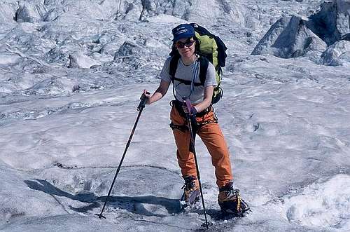
This page is respectfully dedicated to the memory of Rahel Maria Liu (1970-2004) killed by a storm on the Innominata Spur of Mt. Blanc, Aug. 24th 2004. The normal route of Grandes Jorasses was her last completed climb, on Aug. 12th 2004.
I wish I had the right words, Rahel. But I just can't find them.
Overview
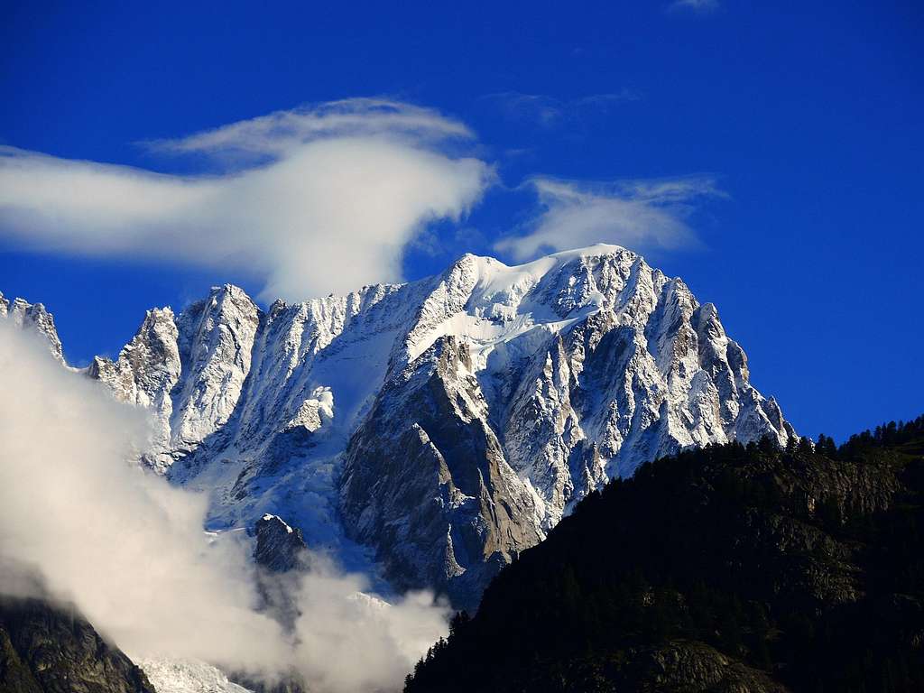
Les Grandes Jorasses are, simply speaking, the most strikingly complex and powerful structure of the entire Mont Blanc massif. Less universally known than the Matterhorn, less slender than the Verte-Dru group and 600m lower than Mont Blanc, nevertheless the Grandes Jorasses exudes, most spectacularly in the famous north face, an air of mystery and power that has no rivals in the entire Alps, except (maybe) for the sinister spire of the Aiguille Noire De Peuterey. If Mt. Blanc is the king of the Alps, the Grandes Jorasses complex is truly the queen.
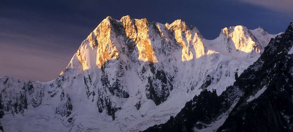
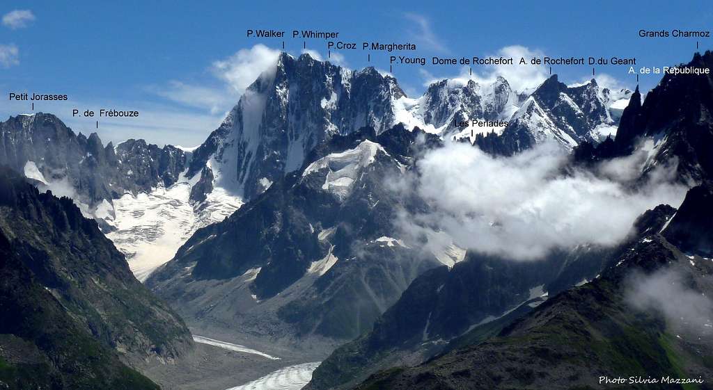
What's called Grandes Jorasses is actually a collection of summits, linked by a relatively regular ridge, 1 km long. From left to right (seen from south)
- Pointe Young (3996m) after Geoffrey Winthrop Young, a very strong British mountaineer of the early XX° century;
- Punta Margherita (4066m), after the queen Margherita of Savoia, wife of then king of Italy Umberto I°;
- Punta Elena (4045m), after royal princess Elena of Savoia;
- Pointe Croz (4110m), after Michael Croz, the great Chamonix guide who accompanied Edward Whymper in many of its climb (including the first ascent of GJ), and died in the Matterhorn tragedy of 1865;
- Pointe Whymper ( 4184m), after Edward Whymper, GJ’s first climber and celebrated XIX° century British mountaineer;
- Pointe Walker (4208m), after Horace Walker, British Alpine Club’s president, who made the first ascension of this summit.
 |
 |
 |
 |
 |
Mountain Description
Grandes Jorasses may be divided in four different sectors and three major ridges:
On the Italian – French frontier:
- The summit ridge. Linking Col De Grandes Jorasses to Pt. Walker, almost all above 4000m, it can be divided in two different sections – the initial (from the Col to Pt. Croz) rocky and narrow, the second (from Pt. Croz to Pt. Walker) snowy and relatively large. On the high snow saddle of the Col De GJ it's placed the Canzio bivouac hut.
In Italy:
- The SW sector. Looking towards Courmayeur, includes the Planpicieux and Grandes Jorasses glaciers, and it’s bisected by the immense pillar of the Tour De Jorasses. On the W of this sector there are the steep and rarely climbed south faces of Pt. Margherita and Pt. Elena. Above the Tour De Jorasses rampart, and below the summit ridge, lies the so called “Upper Plateau”, threatened by a permanent (but very unstable) serac, whose consistency varies from year to year. The Rocher Whymper, a rocky rib of moderate inclination coming down directly from Pt. Whymper, borders this upper plateau on the left. The Boccalatte – Piolti hut lies here at 2800m, on a small rocky island between the Planpincieux and Jorasses glaciers, near a characteristic small peak called "La Bouteille" (the bottle).
- The SW ridge. Called also “Pra Sec Ridge”, it's located between the Grandes Jorasses and Pra Sec glacier. Relatively undefined in the upper part, but mid-way down it forms three rocky spires called Aiguilles De Pra Sec, where several interesting routes have been opened.
- The S face. Also called “Tronchey Wall”, or “Pra Sec face”. Described by Renato Chabod (one of the great MB climbers and historians of the 20's) as “infernally alive”, little known and very rarely climbed (only three unrepeated routes!), this wall is actually the highest rock face of the entire MB massif, going 1435 m. (according to a recent survey) from the top of Pt. Walker to the rimaye on the little and ultra-tormented Pra Sec glacier. It’s, however, not monolithic – overhanging in the lower part, becomes a collection of spurs and towers above, with a marked couloir on the left. While the face itself isn’t too vertical, the Tronchey wall holds another local record – the highest steepness ratio from the top to the valley floor (it goes almost 2800m. in less than 2km). The rock quality varies enormously, being better on the upper towers than in the lower overhangs. Confusion on the name is born by the fact that the (bigger) Pra Sec glacier overlooks the Tronchey hamlet, while the smaller Tronchey glacier overlooks Pra Sec!
- The SE ridge. Also called “Tronchey ridge”. A beautiful feature of the mountain, begins from the Pt. Walker with three well defined towers, becoming horizontal after 800m and forming the minor summits of Aiguille De Tronchey (3456m) and the Aiguille De L’Eveque (3236m), then falling down again over the small hamlet of Lavachey. In the upper part the rock is almost everywhere excellent. Between the Aig. De L'Eveque and the Aig. De Tronchey lies, at 3264m, the tiny Jachia bivouac hut.
- The E face. Almost perfectly triangular, lying between the Tronchey and the Hirondelles ridge, overlooking by almost 800m the chaotic Freboudze glacier, this fantastic face is the mountain's steepes side and has some of the best granite of the massif. The most preminent features of the wall are the lower “Y” couloir, and the prominent pillar on the left of the face. On the Freboudze glacier, on a little rognon, it's placed the Gervasutti bivouac hut (2835m).
- The E (Hirondelles) ridge. Linking the Col Des Hirondelles (so called because the climbers first reaching the col found several swallows) with the Pt. Walker, 750m high, and dividing the Freboudze glacier from the immense Leschaux basin, this ridge makes an almost perfect arc quite visible from the Leschaux hut. The quality of the rock varies, being relatively good on the lower section and mediocre in the upper parts.
In France:
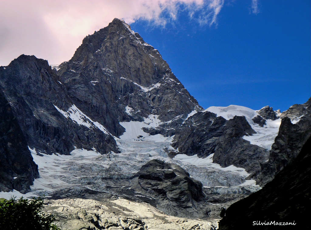
- The North face. An immense wall (one of the most famous in the entire history of alpinism), not the highest but definitely the biggest of the entire Mt. Blanc massif. It has a slight trapezoidal form, 1200m high at the tallest points (the Walker spur) and little more than 500 at the smallest (the Pt. Young spur), and almost 2km wide at the base. Can be divided in seven separate sectors:
- Linceul or NE face. The triangle formed by the Walker spur and the Hirondelles ridge has at its centre an icefield of vaguely arachnid appearance, called “Le Linceul” (the Shroud). To the right of the Shroud, the left corner of the Walker spur has a definite NE orientation, and sees little sun. The general quality of the rock is quite mixed.
- Walker spur. The most famous feature the North Face, it’s in fact a series of successive towers linked by a system of slabs. The lower and the upper part are somehow broken, but most of the spur is made of excellent rock.
- Central Couloir. Another famous feature of the wall, this is a deep couloir (actually, a system of couloirs located into a bending of the wall), that’s both cold and icy. The deepest of the ice couloirs (the one where the Japanese route pass) is more or less permanent, while the others have been reported to have partially disappeared in the recent, hotter summers.
- Whymper rib. More than a spur, this is a face into the face, with again a slight NE orientation. This sector can be divided vertically in two – a lower 55° to 70° icefield 400m tall, and on the top of this the true “rib”, 650m high. It’s the steepest feature of the entire wall, often severely overhanging (there are several huge roofs). The rock here is often very compact, with scarce crack systems, but some sections have been recently reported as quite precarious. It’s also notoriously wet! The area between the Whymper rib and the Croz spur is extremely broken.
- Croz spur. While the Walker spur is the most prominent, the Croz spur is actually the largest and more complex of the two. It’s also less steep, and more exposed to stonefall. The two successive icefield have a moderate angle (50°-55°). In the lowest part the spur becomes almost a ridge, with a system of marked couloirs in the right (NW) side (looking towards the Periades).
- Marguerite-Helene ribs. Another face in the face, with a complex system of goulottes, ribs, pillars and snowfields, following a curve going up progressively steeper. The lower part is a mixed slope, while the upper part is mostly rock. The area of the wall with the poorest rock quality.
- Pt. Young spur. This little spur is accessible from the Col De Grandes Jorasses, and is (surprisingly) made of very sound rock.
At the feet of the North face, on the opposite bank of the Leschaux glacier, it's built the Leschaux hut. (2431m).
Grandes Jorasses in Real Time
This webcam shows the MB massif from the Aig. Du Geant to the Grandes Jorasses (on the extreme right). The image is refreshed every few minutes. Sunrise and sunset time are expecially interesting. The "star" you see sometimes at night at middle-left of the image is the Mt. Frety cablecar station light.
A big thank to Roberto Picchiottino and www.valdigne.com for their kind permission
Huts
In Italy:
- Boccalatte-Piolti Hut (2803 m.) 30 beds. The route is not guarded anymore and due for rebuilt soon Very remote and pleasant place to stay, even for the Mount Blanc massif standard. However, in high summer people coming down from the Jorasses after climbing the north face or the west ridge often crowds it. Approach (diff. EE, 3.30 h, 1200m): from Planpincieux (1600m), in Val Ferret (reachable from Courmayeur by car or in 30 minutes with the bus service), at the upper end of the village, from a huge parking serving a hotel and a restaurant, just before the "Grandes Jorasses" camping. On the opposite side of the parking, behind the restaurant, the little village church is well visible. Take the small road on the left for 100m, turn right and then walk between few houses to get to the village church. Take the trail on the left of the church (sign "Rif. Boccalatte-Piolti", marked "21" or in yellow at regular intervals). The path goes through pleasant forested area (coniferous, beautiful flowers in June) then over a long grassy slope, dominated by the mass of the Grandes Jorasses. Once onto the rocky barrier below the Planpicieux Glacier (200m circa) the trail (always well marked but now sometimes confusing to follow, few more yellow marks would help) cross two small streams to the right (the second can be difficult after a rainy spell), and then goes up a very steep slope of grass and rocks, then climbs up until a metal ladder over a wide chimney (2300m circa). Above, the trail goes up on a moraine on the right side of the Planpicieux Glacier, and then follows its crest until reaching the rock barrier where the hut is located (well visible from below). Climb through a trail cut into the rock and equipped with big fixed ropes (easy, some II°) until the hut.
- Ettore Canzio bivouac hut (3825m.) A wood and metal shelter with 8 beds, blankets and some cooking material, always open w/o warden. Property of the Turin section (Gruppo Occidentale) of the Club Alpino Accademico Italiano (CAAI Gruppo Occidentale, Via Barbaroux 1, 10122 Torino, tel. 011/546031). Recently restored and in general good state. The bivouac is located on the saddle of the Col Des Grandes Jorasses (thus, actually in French territory), and from 1961 replaces the older "Citta Di Monza" bivouac hut, built here in 1950 and destroyed (apparently by purpose) one year later.Approach (diff. D+, 8h): While technically it's possible to reach the col from north (via the Leschaux hut and complex Mt. Mallet glacier, AD, 6 or 7h), or from the south (via the Boccalatte hut, the Planpincieux glacier and the dangerous and difficult rock spur to the right of the col, D-, 7h) nowadays the majority of the climbers comes from the Rochefort ridge, via the Torino hut (3280 m., reachable through the Mt. Blanc cablecar). Click here for a photo description of the ridge.
- Giusto Gervasutti bivouac hut (2835m)The old (and pleasant) wood and metal shelter has been replaced in 2011 by a "high tech" (yeah sure) ugly white and red plastic/metal tube, with a huge window looking towards the valley. Room for twelve, solar panels power, stove, radio, cooking implement, not guarded. Avoid it during snowy winters!. Property of SUCAI sub-section of CAI, via Barbaroux 1, 10122 Torino, tel.+39 11 546031. The access has section threatened by seracs. Approach (diff. F+, 4h, 1100m): from Lavachey (reachable from Courmayeur by car via the Val Ferret road, or using the bus service), cross the Dora river on the small bridge just before the two road switchbacks leading to the Bonatti hut (indication "Freboudze"). The trail goes through dense and beautiful wood (plenty of interesting flora for those interested), and then emerges on the other side on the lonely Freboudze valley. Follow the traces - not always evident, some cairn - then cross the Freboudze torrent (often difficult and dangerous, exp. during the hot season) then ascend on the other side aiming at the evident rock rib coming down from the slopes under the Greuvetta wall (traces, cairns). Enter the little grassy basin under the rib, and climb a well defined 50m dihedral (II°/III° - can be tricky or even difficult if wet or icy). Above, follow the traces up the slope, then reach a small platform where the trail turns NW (until 1986, here was placed the small and historic Freboudze bivouac, then removed and put into temporary exhibition at the Courmayeur Mountain Museum). Ascend the grass slope under the Greuvetta wall, then into the Freboudze upper moraine. (BEWARE - there's a dangerous serac barrier above, invisible from below. Two climbers have died here, and several were near-missed. Don't linger, and avoid traversing in the hottest hours of the day) Cross the glacier in the direction of a rocky island, where the hut is now visible. Scramble up some slabs (beware in presence of verglas) and reach the hut.
- Mario Jachia bivouac hut (3250m) A tiny shelter in wood and metal, located on a little col between the Aiguille de L'Eveque and the Aiguille De Tronchey. Always open w/o warden, 8 places, blankets and some cooking equipment. Property of the Società delle Guide di Courmayeur, tel. + 39 165 842064, fax +39 165 842357. May be one of the least used huts of the entire massif - according to the guestbook, the average is 4 users per year! The location is a superb panoramic spot, but the access goes definitely into the “gruesome” classApproach (diff. AD, 7/8 h., 1600m): There are basically three ways to start the approach: 1) from Tronchey (1654m, reachable by from Courmayer via the Val Ferret road, or using the bus line): follow an unmarked trail starting from the back of the camping site that goes to the right, toward the huge scree cone descending from the Pra Sec basin. This trail crosses a small torrent, then start climbing on the extreme left of the above mentioned cone, often disappearing under the now advancing vegetation. After you reach a small but characteristic rocky shoulder (good reference point in descent!) the trail disappear. Do not continue on the extreme left of the cone, but move to a shallow detritus rib slightly the right, it's a bit less steep. Go up until you reach the top of the cone, near two big boulders (quite visible from below). At your right you should see the Pra Sec river, normally filled with avalanche debris, and beyond that an evident rocky barrier. Cross the river at the very top of the cone (may be difficult) then bypass the barrier via a steep grass slope to the left. 2) The "new" forest trail starting from the Pra Sec hamlet, less than 1 km beyond Tronchey. The trail (built to facilitate the work to build a new artificial banks to the dangerous Pra Sec torrent) starts on the back of the restaurant, and goes through the fores with several steep turns. At some point you will reach the artificial barrier mentioned above and the secondary branch of the Pra Sec river. Continue on the right bank (in the sense of ascent) of the river, pointing toward the evident rocky barrier of the previous approach. Cross it to the centre (small grassy chimney) and you'll find yourself where 1) arrives. This new approach is less interesting and more strenuous than the old one, but in winter or if the Pra Sec river is impassable may be more convenient. 3) Straight from the Pra Sec car park (small bridge). Simply leave the car there, and go up on the centre of the huge cone, somehow to the right of the Pra Sec River bank. Very straightforward (simply point to the top of the cone) but can be awfully tiresome, especially under the sun! Above the first rock barriers there are others rock/grass steps that you must avoid/climb (yellow marks here and there) pointing toward the basin and the stream coming down from the Tronchey glacier. Not difficult but exposed in places. You will find yourself at some point on a big "plateau" at around 2500m, between an evident, big slab wall to your right (forming the lower part of the south face of the Aigulle de L'Eveque, and the crest (to your left) dividing the Tronchey and the Pra Sec glacier, forming a last summit that has been recently climbed for the first time (Pt. Giancarlo Grassi, 2846m). The old trail (the one you find in guidebooks) followed a ramp to the left of the slab wall (100m II°/III, relatively exposed and awkward if wet or icy) once equipped with metal cables that are no more there. The preferred access nowadays simply goes straight up toward the summit of the Eveque (the direction is NE) crossing a rock step with several passages of III°. Above, there's a shoulder mainly composed of easy, rotten rocks and boulders (another cairn here). Traverse to the left (N), following the crest that comes down from the Eveque, until another cairn (2800m). Now, you can see on your left a huge couloir that comes down from the col dividing Aig. De L'Eveque and Aig. De Tronchey. Climb down something like 10 meters, traverse to the left horizontally, and reach the couloir (some stonefall danger). Follow the couloir until you reach a point where you can see the col. At this point, climb the rock/scree slope above (several easy rock ridges) until the hut. As you may see, the access is not only very long and strenuous, but quite complicate. I’ve done it four times, and in the lower slopes I've never followed the same route!
In France:
- Leschaux hut (2450m) Metal and wood, prefabricated building with room for 12. Property of the Club Alpine Francais, Chamonix section (tel: +33 450 53.16.03 fax: +33 450 538247). Click here for more infos. The hut has been recently restored - now holds room for 25. While it's not one of the most frequented huts on the French side of the massif, can be often very crowded. Remember that reservation is mandatory! Approach (diff. F,3 h, 500m but very long horizontal walk.): from Montenvers (1909) follow the indication "Les Refuges". The trail goes horizontally for a while, the stops above several metal ladders. Climb down these ladders (be careful - there's almost always a lot of traffic here, and not always competent) until you reach the border of the Mer De Glace (big boulder and cairns pointing the route to the huts). At this point you have two alternatives - follow the marks and the trail that goes right at the middle of the glacier, or follow the right border of the same. The first option is more straightforward, but cross an "intermediate" area of the glacier that can be awfully crevassed. The second option can be often easier, but is not well marked. The choice depends from the season and the conditions - ask at Montenvers what's best to do. The glacier makes two evident curves - the first to the left, the second to the right, where (from the right) the Trelaporte promontory comes down from the Aiguilles. At this point you must cross the glacier (indications, cairns, etc) to the left, toward a cliff marked on the maps as "Les Egralets", right under the Aig. Du Moine. Ignore the path going up this cliff and toward the Couvercle hut and continue up the Leschaux glacier (more or less at the center) towards the Jorasses, until you see on your left a moraine slope and the little Leschaux hut. The trail to the hut starts near an evident sign, goes up for some easy scrambling helped by a fixed chain, then traverse to the R until the hut.
 |
 |
 |
 |
 |
Getting There
From Chamonix (France)
- by train to Montenvers (1909m.). Timetable varies according to the seasons, usually 8:30AM-6:30PM. Line usually closed from Nov. 15 to Dec. 5. For more information visit the official site of the Montenvers train here
From Courmayeur (Italy)
- By car through the Val Ferret car road until Arnouva (1793 m.).
- By the bus service – one trip each 40 minutes. In Courmayeur the bus can be taken from the Bus Station (near the tunnel highway entrance).
 |
 |
 |
 |
 |
Routes Overview
This is an overview of the many routes of the Grandes Jorasses. Individual routes of special interest will have, in time, their own page.
SW SECTOR
The SW sector of Grandes Jorasses (facing Courmayeur) is really a complex agglomerate of spurs, glaciers, steep ridges and peculiar rock structures, where a great number of interesting lines has been established. Unfortunately, beyond the normal route, the west ridge (and some climb in the modern idiom on the lower part of the Tour Des Jorasses ? that will be covered in the future as a separate summit), most of the lines here see very little traffic. This is partially because of the uneven quality of the rock, but it must be said that it’s actually not worse than in some of the most celebrated climb of the North Face. On the other hand, the recent changes on the Planpincieux on Grandes Jorasses glaciers have made reaching the base of some of these routes much more difficult.
- West Ridge (Jones/Young/Knubel, 1911, III D, 4c, 300m but actually 1km long!).An astonishingly fine traverse over all the GJ summits, normally done as a continuation of the Rochefort ridge. It’s made by two sections ? the initial rock climbing until Pt. Croz, and the mixed/snow ridge until Pt. Walker. The first part is on very good rock, with some incredibly exposed bits, exp. just before Pt. Helene. Some dubious terrain between Pt. Helene and Pt. Croz. At this level of difficulty, it’s one of the most terrific excursions of the Alps, but be warned ? it’s long, serious and no place to be surprised by bad weather!
- Pt. Young south face “Bonatti route” (Bonatti/Peyronel, 1952, TD, 5a, A1, 450m) Gets my vote as the most obscure Bonatti climb ever. Very uneven (the difficulties are concentrated at the beginning and the end, the first part being threatened by rockfall), quite exposed and generally on very sound rock. Another route with just a handful of repeats - maybe just three.
- Pt. Marguerite south face “Alippi route” (Alippi/Pinciroli/Stuffer/Troyer, 1972, TD, 6a, A1, 600m) The lower third is so-so, but the rest is an interesting and sustained climb on good rock and savage ambiance. Serious and rarely repeated, but worth a look.
- Pt. Marguerite south face “Salluard route” (Strumia/Salluard/Salluard, 1937, D+, 5a, 600m) Less sustained and technical than the Alippi route, but more logical, follows an evident crest/spur on the right side of the Marguerite south face. Good rock. As all the other routes between here and the south face of the Dome De Rochefort, crossing the Planpincieux glacier may prove to be quite an adventure by itself!
- Direct route to Pt. Croz (Hasenclever/Klemm/Konig/ Weitsenbuck, 1909, III D, 1200m) It’s the direct line from the top of the Rocher du Reposoir up to Pt. Croz. Forgotten for years, has seen a resurgence of interest because it’s the most straightforward (and safer!) way to reach the upper ridge from the south side ( avoiding the avalanche prone ? in winter - and often impossibly crevassed ? in summer ? Couloir Whymper). Used mainly in descent by parties doing the Croz spur on the north face, or aborting the west ridge traverse. However (in my view) it's a bit more steep than the Rochers Whymper.
- Normal route (Whymper/Croz/Almer/Biner, 1865, III AD+, 4b, 1400m) See this entry for the complete description. A very nice route of medium difficulty that is far from domesticated and can become a nightmare in wrong conditions. In the last few seasons the Walker variant ? crossing the upper Jorasses plateau and then going directly up the south slopes of Pt. Walker ? is becoming less and less frequented, and most of the parties reach the higher summit via the Whymper-Walker ridge. Usually , however, the biggest question mark remains the crossing of the Couloir Whymper, between the Rochers du Reposoir and the Rochers Whymper. Serious. (NB: This route has several variants, few with any real practical interest)
- Ghiglione pillar (Ghiglione/Ottoz, 1948, TD+, 5c, 550m from the glacier) The main flaw of this route is that, from the Boccalatte hut, you need five hours to get to the pillar's base. Once there, the climb is magnificent, and the pillar’s rock very good. The final ice slopes to the upper Jorasses plateau may vary in height and difficulty from year to year.
- Ypercouloir (Comino/Grassi, 1978, V 6, 90°, 300m from the glacier to the upper plateau) Historically speaking, this was the first significant south facing ephemeral couloir climbed in the MB area ? and the most difficult ice route up to that moment. The line follows a narrow gully on the right side of the Ghiglione pillar, the difficulties being concentrated in 250m of mainly overhanging ice, rarely in condition. Brutal, serious, difficult to protect, but surprisingly safe from ice and stone fall. Repeated just a handful of times, the last in 2005 by a young team who praised the route as "30 years ahead its time".
SW (PRA SEC) RIDGE
The most misterious and overlooked of all Jorasses ridges is by far this one. Starting above the Tronchey hamlet it forms first the small group of the Petites Aiguilles, and then the remotes Aiguilles de Pra Sec. Keeping in theme with the general remoteness of this sector of the Alps, the Northern Aiguilles was climbed only in 1971. The ridge continues straight up to the Pt. Walker. While never extreme, the integral ridge is a long undertaking that gets repeated only a couple of time every decade.
- Left Spur of the shoulder 3936 (or Pfann route (Gassner/Pfann, 1909, prob. TD-, 5a?, 600m to the shoulder). This was climbed searching for a more straightforward access to the upper plateau of the Jorasses, and while it look like an interesting climb, it's too difficult to contend for a place as a normal route. The R flank of the route has been interested in 1998 by an enormous (and barely noticed!) rockfall. Unrepeated.
- Pra Sec ridge original route (Ravelli/Rivetti/Croux, 1923, D+ but serious for the grade, 5a, 1400m to the summit) This was the first route to touch the Pra Sec ridge AND the Tronchhey wall, and for the time was quite an exploit. The rock is quite "interesting" at times, and the lowest spur is often grassy, but the crux of the route is the traverse of the aerial Aiguilles de Pra Sec (the original party climbed only the Southern). VERY lonely and maybe repeated once.
- Pra Sec ridge integral route (Bastrentaz/Rabbi, 1964, TD serious for the grade, 6a, 2400m from the start of rock difficulties to the summit) This was the brainchild of Bastrentaz, a Courmayeur lawyer whose climbing career is in need of a reassesment. It connects three itineraries - Rivetti/Ravelli/Croux original, Pfann exit and the link-up between the Petites Aiguilles and the Aiguilles de Pra Sec, climbed in 1954 by Bourdillon (yes, that Bourdillon), Rawlinson and Viney. Then Bastrentaz and Rabbi returned in 1971 to climb the Northern Aiguille de Pra Sec, christening "Aiguille Chichin", after Ravelli's nickname. It's a very long route, on places that are amongst the most savages of the Alps, and thus it sees almost no traffic. And for some reason the people climbing here seems to shun publicity (the first winter ascent was done in 1990's by two Courmayeur guides who want to remain anonymous still today...
S FACE (TRONCHEY WALL)
The routes upon this wall (the highest of the entire massif, and the last one to be climbed) while definitely obscure items, are holding several records. For instance, the Pra Sec glacier had been never crossed by human beings before Alessandro Gogna and Guido Machetto climbed their line in 1972! All the routes described must be approached directly from the Tronchey car park (and camping); there’s no intermediate hut. In other words, you’re on your own, in one of the last truly adventurous terrains of the massif, and a retreat from the upper part of this wall in bad weather would be impossible. Because of the relatively low altitude of the wall base and the southern exposure, rapidly melting snow can create spectacular but dangerous waterfalls on the left hand couloir.
- Upper Tronchey route (Rand Herron/Croux/Croux, 1928, prob. TD+, 5a?, 60°, 1000m). This was actually a deviation from the Tronchey ridge, opened by Rand Herron and his two Courmayeur guides when they found the ridge impassable. Cross diagonally the upper side of the wall. Unrepeated.
- Gogna-Machetto (Gogna/Machetto, 1972, prob. ED2, 6°/6b, A1, 1400 m.). The two Italian climbers (a very talented duo) followed a line slightly to the right of the lower overhangs, then went upon the spur that divides the wall in two. They described the route as very long, strenuous, with several aid and mixed pitches, and wet rock on the lower half. Unrepeated.
- ”Direttissima” - “Gianni Comino Memorial Route” (also known as "Phantom Direct")(Grassi/Luzi/Rossi, 1985, VI 6, 90°, 1400m) This bold achievement is the longest technical ice route of the entire MB massif, and the second longest ephemeral couloir of the Alps. Follows a continuous line of icefalls and gullies that first ascend to the right, then a deep and narrow snow/ice couloir on the left. The key is a 200 m. leftward traverse right in the middle of the route, over snow and ice covered slabs, apparently non-reversible. Can be done only in particularly cold conditions. Unrepeated.
- "Plein Sud" (Appino/Coranotte/De Leo/Sanguineti, 2010, VI 6, WI5, M6+R, 1000 m from the rimaye to 50m below the Third Tower of Tronchey) The line initially eyed by Grassi, going straight into the enormous and deep chimney/gully between the Third Tower of Tronchey and the wall central pillar, was finally (almost) climbed in 2010. "Almost" because the FA team was stopped a mere 50m below the summit ridge by a combination of rotten snow and impassable slabs. Still, an exceptional feat and one of the greatest in the range after the turn of millennium. Likely to get unrepeated for a long time as it requires a particular set of conditions to be accessible.
SE (TRONCHEY) RIDGE
This elegant, solitary and (in the upper part) exposed ridge, creates a perfect square corner between the E face and the Tronchey wall, and is another overlooked area yet not fearing comparison with the most celebrated ridges of the fashionable part of the massif. However, fact speak for themselves ? the little Jachia hut at the base of the ridge sees an average of only 4 visitors per year! This may be seen as a curse, but in fact it's the blessing of the Tronchey ridge ? one of the few corners of the massif where you can breath the same atmosphere the big pioneers breathed. However, it’s necessary to remind that every route here, while not extreme, is nevertheless serious, and should be attempted only by parties technically competent and physically fit.
- Tronchey ridge ? original route (Croux/Gilberti, 1936, TD, 6a, 950m). This superb line was the earliest on this ridge, and a testament to the ability of Elisee Croux (nicknamed “the monster” by his English speaking clients), a Courmayeur guide who never got the recognition he deserved. Follows a natural line up the two towers, then goes directly up the crest of the third tower, on a variant set by Lionel Terray in the first repetition. Excellent rock everywhere, and (according to recent reports) only two pegs left in place.
- Tronchey ridge ? Integral route(Bosio/Ferrero/Manera/Ribetti, 1983, TD+/ED1, 6a, A2, 950m) More strenuous and sustained than the former, follows the ridge all along the summit crest, in a wonderfully exposed situation. Again, while technically not too extreme, this is a very serious route ? if the weather turns bad, retreat will be difficult.
EAST FACE & E (HIRONDELLES) RIDGE
One of the most beautiful rock faces of the Alps, almost entirely made of wonderfully solid granite (much better than anywhere else in this mountain!) the east face is Grandes Jorasses most haunting vision. Truly a "mountaineer's face", little know outside climbing circles, all the routes here are held in special consideration, if only because rarely repeated and always by talented parties. The major problem is the approach - the classic traverse from the Col Des Hirondelles may be dangerous in the lower part. In recent years, some repeater as reached the lower "Y" couloir on the L, traversing from the Tronchey ridge over a system of ledges. It's a safer approach, but is technically more difficult, and forces a long climb from the bottom of the Val Ferret.
- “The Pillar” (Cavagnetto/Rosso, 1988, ED3, 7a, A2, 750m). Follows the evident pillar to the L of the Gervasutti route. Another strenous route of reported high difficulty, probably easier to reach from the Tronchey ridge.
- Classic aka Gervasutti route (Gervasutti/Gagliardone, 1942, ED2, A1, 6b sustained, 750m) . A tremendous exploit for its time, remained the most difficult rock climb of the massif until 1962. Afterwards, has been repeated little more than 10 times in its original line, and always by famous and competent parties (notably Joe Tasker and Dick Renshaw in 1974 and Renato Casarotto - alone and in winter - in 1981). Major difficulties are concentrated in the middle 350m. Exposed, athletic and difficult to protect. Offers several variations and is not evident - very little gear remains in place. Currently much more serious and technically difficult than the Cassin on the north face: the third winter ascent (January 2005) was made in six days, and the climbers reported harder-than-expected pitches both in aid and free climbing.
- Central route (also know as "Groucho Marx") (Delisi/Delisi, 1983, ED3, A3,6b, 750m). Follows the huge dihedral splitting the central "shield" a bit on the R. Has several hard pitches over exposed overhangs and roofs, and seems to be a good target for big wall specialists. Apparently unrepeated.
- "Little Big Men") (Batoux/Doudet, 2006, VI M6, A3 ,6b, 750m). For those who are not yest convinced, it's still possible to open serious, ultra-committing adventure climbs even in the MB massif. "Little Big Men" (dedicate to the memory of JC Lafaille and Damien Charignon) goes parallel (and on the left) of "Groucho Marx" (with whom has in common 2 pitches and half). A very hard big wall route sandwiched between two very hard section of mixed climbing, in the most remote area of the massif, not for the faint hearted. Opened in capsule style (with a base camp on the top of the Y couloir), over 8 days. A funny side note - for "some reason" Daudet and Batoux decided to add to the topo the 250m of the Couloir des Hirondelles (III M5+), making this a route entirely in Italian territory... starting from France. Ah, those French...
- Bovin-Diafferia (Boivin/Diafferie, 1981, TD, 750m). Basically this is a long variation of the Hirondelles ridge, going over the evident icy ramp parallel (L) to the ridge. Was opened by Boivin and Diafferia after a failed attempt to climb the route that was later to become "Groucho Marx". Repeated at least once.
- Marine Givree (Dececures/Robach, 2007, V 5, M5, 750m). In 2006 two Chamonix guide have opened a winter variant of Biovin/Diafferia line, starting directly from the Hirondelles. According to their opinion, this is the easistes line of the East Face.
- Hirondelles ridge (Chenoz/Gaia/Matteoda/Rey/Rivelli/Ravetti, 1927, IV D+, 5c, A1, M, 750m). A splendid route looking over the majestic N face and the savage Freboudze basin, has only one hard bit, the so-called Rey crack (5c). But it’s a high mountain route that shouldn't be underestimated. If icy or snowy, the grade indicated increases notably
NORTH FACE
This imposing wall has an almost mythical status on mountaineering circles, and there’s little doubt that opening a new route on the “Paroi Nord” of the Grandes Jorasses means gaining much prestige, especially on the heavily hyped European climbing scene/. And there’s no doubt that NO route of this face is less than serious and difficult, even the popular lines, like the Linceuil and the Cassin route. Some of the hardest climbs of the entire history of alpine climbing have been made here.
Thus said, reading this list may be a little confusing for the novice, because the grades for high difficulty, seldom-repeated routes are, admittedly, all the same. In other words, it’s impossible to make a meaningful “chart” of the most difficult routes of this wall ? given the enormous differences in conditions, weather and material between the FA and the repeaters. However, there are two different tendencies that may emerge reviewing this list. The first is that many repeaters, especially locals (i.e. from the Chamonix scene) tend to criticise as “overrated” many lines put up by “foreigners” (i.e. people coming from outside the Chamonix scene). The second (recent) trend is to re-evaluate the few, hardest lines put from 1960 to 1980, and, conversely, to downgrade a bit the most publicised exploits of the 80’s and 90’, often found by repeaters to be no more difficult than the older routes.
This is a welcome trend towards a level headed appraisal of the history of this tremendous wall, and could probably help future repeaters to appreciate more the efforts of their predecessors.
- Linceul
The giant icefield left of the Walker spur, under the Hirondelles ridge. With the recent spate of dry, hot summers, it's now become a predominantly winter/autunm objective.
- "Coulee Douce" (Delmas/Perroux, 1985, II D, 60°, 400m) . Probably the easiest route of the face, and a good way to start climbing the Hirondelles ridge from France.
- "Ma-Ika" (Sokolowski/ Wlodarczak, 2004, TD, V, 80°, 700m + 200m in common with "Coulee Douce") . Follows integrally the rock spur between the Col Des Hirondelles and the Little MacIntyre corner - on the left of Coulee Douce. Look pretty interesting - and very panoramic!
- "Hugues d'en Haut" (Gabarrou/Coranotte, 2008, TD, 600m) . The shortest and easiest route of those opened by "Le Gab", goes parallel and on the L of the "Little MacIntyre", sharing - probably - most of the qualities of that route. Gabarrou has dedicate di line to Hugues D'Aubarede, a French climber who died in tragic circumstances on K2 in summer 2008
- “Little MacIntyre” (MacIntyre/Rhodes/Todd, 1976, IV 4+, 70°, 600m). The “other” MacIntyre route on the Jorasses, steep and surprisingly difficult. Some party felt it's better than the Shroud ? and it’s safer too.
- “Le Linceul” - (The Shroud) (Flematti/Desmaison, 1968, IV 4, 65°, 750m to the Hirondelles ridge, 1100m to the Walker). Opened in 10 days of continuous climb (plus 3 of preparation) by a famous team, was one of the last great alpine ice routes before the curved tool revolution. When the “piolet traction” technique was established, the Linceul's status was steeply (and unjustly) diminished. Still hard ? and dangerous. Most repeaters use the direct (R hand) start set in 1963 by Berardini and Paragot (80°) in a very early attempt to the route. The (epic) solo ascent was made by Ivano Ghirardini, on February 1975.
- “Magic Line” (Profit/Radigue, 1983,VI 6, 1100m). Also called "Super Linceul". Repeated twice by Christophe Profit. Links the left hand start (climbed by Graham and Hyslop in 1980, V 5+) with (probably) the direct finish put by Sachetat and Seguier in 1983, V 6. This last goes over an evident corner on the left of the Walker spur, on very rotten terrain.
- “Monomania” (Desecures/Sourzac, 2011, VI 5, M6+/A2 or M7, 1100m but only 400m are independent). During an attempt to repeat the Magic Line, Jorasses regular Desecures and Sourzac climbed the ramp to the right of the original Sachetat and Segurier finish. It's the same ramp attempted by Desmaison in 1971 trying to escape from the Gousseault line, when he noticed Serge becoming unwell. But of course with the 1971 technology it was impossible even for him to succeed. Defined "demential" by Desecures
- Pt. Walker spur and Central Couloir
The tallest section of the wall, the best looking and the most sought after. Overall difficulties change considerably according to the weather, and under severe winter conditions some sections are simply impassable.
- “Gousseault” (Bertone/Claret/Desmaison, 1973, VI 6, 6a/5c, A1/2 or 6c, M5/M6, 90°, 1200m) Desmaison and Gousseault attempt to open this line in 1971 ended in a much publicised and still controversial tragedy (Gousseault died of exhaustion and Desmaison was saved literally in extremis). The seriousness of this route is in a class of its own. Repeated eleven times, 38 pitches long, physically very demanding, still (probably) the hardest line reaching Pt. Walker from this side. The rock quality is uneven in places, but not worse than the rest of the face, and its reputation of being a bowling alley was clearly wrong. Requires at least three if not four bivouacs. With a recent lower variant, has become predominantly a mixed route that can be climbed without removing crampons. Francois Marsigny, who made the fifth ascent of this line in 2003, thinks it one of the best mixed routes of this class in the entire Alps, deserving classic status. In 2007 this line was finally freed by Guy Robertson and Pete Benson, who confirmed the astonishing quality of the climb.
- “Scala di Seta” (Smith/Sorenson, 1977, , ED+, VI+ and A0, 90°, 1200m) Until 2008, the story of this route was one of the greatest "disappearing acts" of the history of alpine mountaineering. For 30 years, it was believed that Smith and Sorenson (two underrated but pivotal figures of the hard climbing scene of the late '70) had "just" made the first summer ascent (and third or second repeat) of the "Gousseault". But in autumn 2008 Smith discovered, under completely fortuitous circumstances, that they had, unknowingly, opened one of the hardest, longest and boldest mixed line of the NF of the Jorasses. The route shares only 30% of the Gosseault, as it starts on the (alleged) "Rolling Stone" ramp to the R of the 1971/1973 start, reaches the Gousseault at the beginning of the First Ramp, and deviates somewhere through the Second, taking a detour to the R. The spectacularly nasty crux is on the L of the "Red Tower".
- “Rolling Stone” (KutilProchaska/Slechta/Svejda, 1979, 6a, A2, 80°, 1100m). Follows the left side of the pillar in an area with a particularly poor rock quality (the leftmost side of the Walker spur crest). Comparable to the “Gousseault”, but probably less serious, reaching the Cassin route below the Red Tower. Repeaters think that in cold condition could provide superb mixed climbing, particularly if a direct link with the “Gousseault” could be made. After the discovery of "Scala di Seta", the author of these notes has come to believe that original 1979 line of this route was NOT the one of the 1986 winter repeat, but somewhere nearer to the "Direttissima".
- Gabarrou "Direttissima" (Bouvard/Gabarrou, 1986, 6c-7a, A1/A2, 1200m). An attempt to “straighten up” the Cassin route, while (apparently) extremely hard, has never gained particular popularity. As "Rolling Stones", joins the Cassin below the Red Tower, then goes straight through the Red Chimney , thus avoiding the “reverse ledge” of the classic route.
- Cassin route ? classic route (Cassin/Esposito/Tizzoni, 1938, TD+/ED1, IV, 5c/6a, A1, 1200m). The second route opened on the wall, this was the last of the “three classic north faces” to fall, by far the most technical of the three. While very popular, and a early victim of excessive pegging, remains a hard, demanding route requiring experience, stamina and speed. A retreat from the upper part of the wall may be greatly dangerous, if not impossible. And winter condition may increase exponentially the difficulties indicated. While it's now relatively common to see fast parties do the route in less than 10 hours and sleep at the Boccalatte (or even in their beds in Courmayeur or Chamonix!), still common mortals should consider the eventuality of one (or event two!) bivouacs.
- “L’Enfant Et La Colombe” (Batard, 1992, 5c, A1, 1150m) Another controversial route, opened by Batard over a couple of weeks of permanence on the wall, following more or less all the spur right flank, between the Cassin and the Central Couloir, and joining the classic route in the last 250m. Does not cover enough new terrain (and it’s too exposed to stonefall in summer) to be popular.
- MacIntyre - Colton (Colton/MacIntyre, 1976, VI 6, A1, 90°, 1150m). The original name was “Rollerwand”. The most popular, and probably still most logical ice route of the wall, and a daring, well-executed exploit for the FA party, it's now repeated with some regularity (in winter). The central section is technically severe, and very difficult to protect. The most popular line today joins the right hand goulotte of "Alexis" between the middle and upper icefield, then ends the route (via the last bit of the Japanese route) at the little 4143m breach between the Walker and Whymper summit. This line is easier and more often in conditions, but the original line (going straight up the top of the Walker spur over mixed terrain, is more elegant and satisfying (and harder). In 2008 the route was soloed by Ueli Steck in a record 2h15m - but the real record was that Ueli managed to descend an incredibily snow normal route in time to be in Chamonix for dinner!
- “Extreme Dream” (Boivin/Vionet-Fuasset, 1987, VI 6, 1150m). Follows the leftmost (and steepest) gully of the Central Couloir, with a long section in common with the MacIntyre. Really a significant variation rather than an independent line, but according to repeaters, more sustained than the MacIntyre.
- Japanese Couloir (Kanda/Kato/Miyazaki/Nakano/Saito, 1972, VI 6, 6a, A1/A2, 1150m). The Japanese remained on the wall for two months and used extensively fixed ropes. The line goes into the deepest, left hand gully of the Central Couloir, and looks absolutely nasty from every point of view. Repeated twice in its entirety, but the final section is now regularly used by "MacIntyre" repeaters.
- “Alexis” (Gabarrou/Robert, 1993, VI 6, 6b, A2, 95°, 1100m). Another exploit signed Gabarrou, still awaiting a second complete ascent. Links the first half of the MacIntyre route with a series of channels and gullies crossing the little icefield at the top of the Central Couloir, and ends up against the left side of the Whymper rib. The middle section is now reyularly used by "MacIntyre" repeaters
- Pt. Whymper rib
These three routes may be, technically speaking, the hardest of the entire wall, but are rarely considered "good" routes. The upper “shield” of the rib is made of compact rock (whose quality seems to vary quite wildly) and is an obvious aid-climbing target. But it’s also at the top of a 400m ice slope that’s 50° steep, bombarded by falling rocks and rarely in condition. Retreating from the upper part of the (overhanging) shield is basically impossible. No bivouac site on the upper wall ? bring a portaledge.
- “Eldorado” (Babanov, 1999, 6b, A3/A4, 90°, 1100m). Follows the left-hand side of the Whymper rib. While it’s disputed that this is the most difficult route on the Grandes Jorasses (repeater Lionel Daudet found it over-bolted), there’s little doubt that we’re more or less in the same league, and Babanov solo ascent was definitely nothing short of awe-inspiring. Almost impossible to complete without many bivouacs
- "Directe de l’Amitie" (Audobert/Feuillarde/Galy/Seigneur, 1974, VI 5, 6a, A4, M5/M6, 55°, 1100m). Goes straight through the Whymper rib's “shield” Much maligned initially because of the siege tactics used by the FA (complete with sherpa!), could be the most serious route of the north face, a mix of alpine climbing and big wall (portaledge normally used). Repeated seven times, always with many bivouacs, and large use of aid climbing, at some point considered to be more difficult than "Divine Providence". It must be said, however, that a British/German team who attempted the fifth (winter) repetition, and was rescued from the wall because of frostbite suffered by one of the climbers, spoke of rotten rock and compressed gravel up until the last five pitches. It's possible the line may have been severely damaged by a huge rockfall in 1999: but again, in 2006, Jorasses specialists Patrice Glairon Rappaz and Stephane Benoist, along with Paul Robach, made the coveted fifth ascent, and reported again compact rock, and a sustained climb, gaving back to the "Amitie" the title of "most difficult route of the Jorasses". To be continued...
- Bonatti-Vaucher (Bonatti/Vaucher, 1964, 5c, 85°, M5/6, 1100m). Follows the right hand crest of the Whymper rib. Another route whose reputation was, for some reasons, lost in the frenzy of enthusiasm for the “new lines”. In fact it’s tremendously difficult, and was opened by Bonatti & Vaucher in particularly fearsome conditions (ropes repeatedly cut, etc). It’s been said that this experience convinced Bonatti it was about time to leave jet set climbing. Repeated only five times (twice solo, by S. Svetic and Courmayeur guide Giovanni Bassanini). On Sept. 2004 Francois Marsigny did an incredibly fast ascent of this route in just 14 hours, thanks to good early autumn conditions. According to him, it's more difficult than the MacIntyre-Colton, but less than "No Siesta".
- Pt. Croz spur
- “No Siesta” (Glejdura/Porvaznik, 1986, VI 6, 6a, A1, 90°, M8 if free,1000m). Another mythical line and another well publicised exploit when first opened, in recent times has been reckoned as probably just a little harder than the Gousseault (even if one team has called it as the most difficult mixed climb of the Alps.). Crosses an area of dreadful rock quality, going into the no-man’s land between the Whymper rib and the Croz spur. Repeated six times, only once completely free. Tomo Cesen alleged early free solo (the first time a repeat was claimed) is now discounted by many as very unlikely.
- “Manitua” (Sveticic, 1991, 6c, A3, 70°, 1100m) One of the few recent routes that could have achieved a relatively popular status, this very hard line crosses transversally (via a system of ramps and cracks the “miniwall” on the NE side of the Croz spur. It’s a very hard route (again), but on decent rock, and follows a logical line. This solo by the late Svetcic was at the time hailed as the hardest climb yet put in the Alps.
- “Le Nez” (Bole/Cortese, 2005, 7b, M4, 1100m) Opened by "Bubu" Bole and Cortese over almost a month of non continous permanence on the wall, it's the first route on Grandes Jorasses since 1974 opened using fixed ropes and bolts. The goal of the FA was to create a continuos free climbing line over the L flank of the Croz spur "where could be possible to climb with climbing shoes and magnesite", somehow of a bizzarre claim . While no-one denies Bole's status as one of the strongest free climbers around, and it's difficult to assess this route until someone will climb it in a bolder style, the whole thing sounds a bit out of place here.
- “Decalage” (Lafaille, 1999, 6a, A3, 55°, 400m). The zenith (or nadir) of Lafaille “media blitz” climbs, and definitely more a publicity stunt than anything else, this is a big wall route established on the left (NE) side of the central part of the Croz spur. Lafaille spent 8 days alone on the wall, never reaching the top.
- “Le Chemin Des Etoiles" (Lafaille, 1992, 5/6 some 6b, A3/A4, 55°, 1000m). Lafaille strikes again! It’s a long variant of the "Keine - Werner Direct", itself a variant of the Croz spur route, going parallel to the crest on the NE side, above the characteristic “mini wall” on the left side. Probably unrepeated.
- Croz Spur (Meier/Peters, 1935,TD+/ED1, 5c, A1, 60°,1100m). The first route of this wall, became the target of a race that, while less publicised than the one for Eiger, lasted a decade. In the end, three brilliant teams - including a woman (the amazing Loulou Boulaz) and Giusto Gervasutti (with Riccardo Cassin the best rock climber of that age), climbed it less than 48 hours one from the other. Technically less sustained than the Walker Spur (and less steep) it is actually a more committing and overall serious route, thanks to the low traffic rate and the lack of gear left in site. It’s also a bit more exposed to stonefall. One advantage is that retreating down the spur, while still difficult, isn’t an impossible task.
- Pt. Helena rib
- “A Lei” (Gabarrou/ Batoux/ Robert, 2003, V 5, 6b, A2+, M5+, 850m). A new and difficult line by the ubiquitous Gabarrou, going straight up to the gendarme between Pt. Croz and Pt. Elena (now named Pt. Magali).
- Slovenian route (Knez/Matijevec/Vidmar/Zupan, 1977, V 5, 4c/5a, A2, 850m). Comparable to the Croz spur route, but shorter and on worse rock.
- Polish route 70’ (Chrobak/Poreba/Wroz, 1970, V 5, 5c, 60°, 750m). One of the earliest alpine routes put on the future protagonists of the “Polish wave” of the ’80s, is mostly a hard mixed route on dubious terrain. Follows the line of a crest descending from a very visible “gendarme” sitting on the summit ridge, to the left of Pt. Helene.
- Polish route 75’ (Kurtyka/Kukuczka/Lukaszewski, 1975, 5c, 750m). Opened by two future giants of the Himalayan scene, appears to be moderately more interesting than the former, and has seen some repetition.
- “La Belle Helene” (Parkin, 1999, V 5+, A1, 90°, M?,750m). Opened by Parkin while he tried to repeat the Polish route 70’, follow a goulotte on the right of the crest. He compared the route to the Carrington-Rouse on the Aiguille des Pelerins.
- “Mctho” (Aubert/Lafaille, 1997, VI 6, A2, 750m) Yet another Lafaille extravaganza. Follows an ephemeral couloir to the left of the Helen “spur”, and is apparently very, very difficult, but most of the final part is more or less in common with the Polish 75 route. The only route on the wall opened by a woman - Cham guide Francoise Aubert (if one is not considering Lolou Boulaz on the Croz spur).
- Yugoslavian route (Gradisar/Herzog, 1976, 5c, A2, 55°, 750m). The most straightforward climb up to Pt. Helene, reportedly interesting, mostly on mixed ground.
- Spanish route (Aguado/Pablo, 1983, 5c, 75°, 750m). Another attempt to make a direct route to the Elena. Repeated at least once.
- Pt. Margherita spur
This part of the wall is similar to the NF of the Droites, but shorter, rockier and much more exposed to rockfall. All these route have been hardly repeated.
- Heidi (Batoux/Dumarest/Gabarrou, 2005, VI 4R, 5c, A3, M6, 850m). A line originally pioneered by a group of Aosta Valley guides (Ezio Marlier, Herve Barmasse and the late Massimo Farina) to less than 150m from the summit, "rediscovered" few months later by "Le Gab". It's a very mixed route, with a lot of technical aid climbing requiring beaks, hooks and al. Gabarrou was hit by a stone in the last few pitches and had to be lifted away on helicopter.
- Gabarrou-Appertet (Appertet/Gabarrou, 1992, 6b, A1, 90°, 850m). Contrarily to other reports, this is not an ephemeral couloir, but a mixed line much similar to the Couzy-Desmaison route. The FA team climbed in appalling conditions, practically under continuous bombardment of ice and rock falling from the headwall. Repeated in 2006 by Clouet and Dumarest.
- Margherita Spur (Couzy/Desmaison, 1958, TD+, 5c, A1, 60°,800m) The third route opened on the wall, even if just beating the Cavalleri-Mellano line by a mere two days. Difficult but not extreme, on broken terrain, first half on ice/mixed, second on rock. Unrepeated for decades, has still seen a handful of climbs, and has a somehow mixed reputation.
-
- Pt Young spur
- “Reve Ephemere D’Alpiniste” (Ghirardini, 1994, V 5, 6a, A2, 65°, 800m). Another ephemeral couloir, this time from Ivano Ghirardini, the brilliant (and outspoken) Italo-French climber who soloed the alpine NF winter trilogy for the first time in 1978 (and without radio, helicopters, etc.). The first part was climbed with Slavko Svetic, then Ghirardini went solo for the last (harder) section. After ten years of oblivion, has been climbed again in 2005 - the repeaters found it very good and reccomendable.
- Knez-Skok (Knez/Skok, 1980, 4c, A1, 55°, 750m). One of the easiest routes of the wall, follows the main couloir between Margherita and Young, exposed to stonefall on the lower part, but quite safe on the upper side. The exit is one the little col on the left of Pt. Young
- Desecures-Robach(Desecures/Robach, 2003, V 5, M5+, 750m) A right hand variant of the Knez-Skok, on more technical terrain
- Polish direct (Furmanik/Zdzitowiecki/Heinrich , 1958, 5c, A1, 70°) Simply another approach to the Cavalleri-Mellano (see). It had been already descended when the Polish team did it the other way round.
- ”Crystal Palace” (Ghirardini, 1991, TD+, 80°, 850m). Another difficult ice route by Ghirardini, and an alternative approach to the Cavalleri-Mellano spur
- Cavalleri-Mellano (Cavalleri/Mellano, 1958, 5c, A1, 70°, 400m) The fourth route opened on the wall (Mellano's original objective had been the Margherita's spur) and the only route on the NF reachable (in few minutes) from the Canzio bivouac hut. Is also a good rock climb on surprisingly sound terrain, and may be an alternative start to the W ridge, or a climb on its own. Often in good conditions, and quite sustained for the grade. Relatively popular.
 |
 |
 |
 |
 |
Camping
- In Italy
Free camping in the Aosta Valley region is not allowed below 2500m. However it's tolerated if you don't create hassles or particular troubles. This includes, of course, making fires in the woods! Here's a list of camping in Val Veny, all accessible by car or by bus from Courmayeur. In strict alphabetical order:
- Camping Aiguille Noire (www.aiguillenoire.com, ) - in Val Veny, at Zerotta, near lower station of the chair lift. (tel. +39 0165 869041 Fax +39 0165 843097). A good place for families and big groups. Used to be also the cheapest, but price right now are almost the same everywhere.
- Camping Cuignon – in Val Veny between Zerotta and the military barracks (tel +39 0165 869073 Fax +39 0165 842861). This one is a bit of a question mark for me, because I don’t know anyone who’s been there. For outside it looks quite neat and smaller than Aiguille Noire
- Camping La Sorgente (www.campinglasorgente.net, ) – in Val Veny, in a clearing of the forest called Peuterey, exactly under the Mont Noir south face (tel. +39 0165 848209 or, in summer +39 0165 869089). The location of this one is gorgeous (the ancient forest nearby is said to have been a Celtic worship centre). They’re really climber-friendly, and the camping itself is well organised.
On the Val Ferret:
- Camping Grandes Jorasses ( www.grandesjorasses.com) in Val Ferret between Planpincieux and the golf course. (tel +39 0165 869708). Being near Planpincieux, it’s a lively and well placed on a partially wooden area.
- Camping Tronchey – in Val Ferret just in front of the entrance of the golf club, right under the monstrous Tronchey Wall of the Grandes Jorasses. (tel. +39 0165 869707). Nearby there’s Bar Tronchey (or “Chez Giulietta”), where at noon you can eat an incredible rabbit with polenta.
- If you’re willing to spend a little more, a nice alternative to camping can be the ( Chalet Val Ferret). It’s a seven room little hotel + restaurant at Arnouva, where the Val Ferret road ends – just in front of the opening of the Triolet basin. The place is beyond gorgeous, and you’re in a good position both for climbing and hiking. A guide who’s a friend of mine used it for his climbing stage for kids and was really enthusiastic. Also, you can ask the manager for any kind of indication on the nearest sport and trad climbs of the trendy Triolet area.
- On the other hand, if you don’t like camping and you’re tight with money, you can consider sleeping in one of the low altitudes “refuges”. There are the ( Elisabetta hut ), at the head of Val Veny near the Col De La Seigne, the ( Elena hut ) and the (UGET Monte Bianco hut) In all these places accommodation varies - the Elisabetta is quite spartan, the Elena almost a luxurious, the Monte Bianco somewhere halfway. If you want to consider staying there for several days, you’ve to book well in advance (In August and July these places become packed with hikers doing the Tour De Mont Blanc.)
- In France
My knowledge of the camping sites in Chamonix is extremely limited, and so Diego Sahagun kindly provided the following information:
- Les Deux Glaciers 80, Route des Tissières, Les Bossons F-74400 Chamonix-Mont Blanc Tel : +33(0)450531584
- L'ile des Barrats 185, chemin Ile des BarratsF-74400 Chamonix-Mont Blanc Tel : +33(0)450535144 (Diego recommended this one as a good camping)
- Les Marmotes 140, Chemin des Doux, Les Bossons, F-74400 Chamonix-Mont Blanc Tel : +33(0)450536124
- La Mer de Glace 200, Chemin de la Bagna, Les Praz, F-74400 Chamonix-Mont Blanc Tel : +33(0)450536477
- Les Rosieres 121, Clos des Rosières, Les Praz, F-74400 Chamonix-Mont Blanc Tel : +33(0)450531042
- Les Arolles 281, Chemin du Cry, F-74400 Chamonix-Mont Blanc Tel : +33(0)450531430
- Les Cimes 28, Route des Tissières, Les Bossons, F-74400 Chamonix-Mont Blanc Tel : +33(0)450535893
- Les Drus 114, Chemin de la Corba, Les Bois, F-74400 Chamonix-Mont Blanc Tel : +33(0)450534920
- Les Ecureuils Chemin des Doux, Les Bossons, F-74400 Chamonix-Mont Blanc Tel : +33(0)450538311
- Le Glacier D'Argentiere 161, Chemin des Moillettes, F-74400 Argentiere Tel : +33(0)450541736
- Les Molliases Chemin à Batioret, F-74400 Chamonix-Mont Blanc Tel : +33(0)450531681
- Les Verneys 180, route des Tissières, Les Bossons F-74400 Chamonix-Mont Blanc
- Le Gran Champ right behind the Novotel, Les Bossons (F-74400 Chamonix-Mont Blanc) Tel : +33(0)450530483
Mountain Conditions
- Italy For all informations on the mountain conditions you MUST contact the Bureau Des Guides of Courmayeur (tel. +39 0165 842064; fax. +39 0165 842357; email info@guidecourmayeur.com). They’ve an excellent local weather service, and are always well informed on the conditions up there.
An official source of informations on mountain condition for the Italian side of the MB massif is the Fondazione Montagna Sicura , the Safe Mountain Foundation, a guide sponsored organism that work in collaboration with the French OHM to create a network of information exchange for alpinist. It's very important you check their multilingual website or contact them at
Loc. Villard De La Palud 1
11013 Courmayeur (AO)
Ph: +39 0165 897602
Fax: +39 0165 897647
E-Mail: villacameron@fondms.org
The meteo forecast as seen from the nearby Gressan (Aosta) weather station:

- France Coming Soon!
![]()
![]()
![]()
![]()
Origins of the Name
While the matter was once much debated, it's now generally accepted that "Jorasses" derives from the Celtic term "juris", a word signifying “high altitude forest”, and widespread in the alpine area in many forms - the most famous being "Jura", the hill chain near Geneva that, because of its fossil fields, gave in turn the name to the Jurassic age. It's probable that the area of the Val Ferret right under the Grandes Jorasses was once covered by dense woods, and is now believed that this zone (and the Val Veny) were Celtic worship centres. -
![]()
![]()
![]()
![]()
![]()
Red Tape
French side:given the relative high altitude and remoteness of the French base of approach (the Leschaux hut), on the French side, there are no specific rules or prohibitions, and very little control.Italian side:in the area mineral and flower collection is forbidden. The same goes for making fires, and free camping under 2500 m. Hunting and fishing goes under local seasonal rules (ask in Courmayeur).
Remember that private access to the Val Ferret road is regulated from 1 to 20 August
![]()
![]()
![]()
![]()
![]()
When To Climb
Summertime
External Links
- caranorte.com Grandes Jorasses climbing in spanish
- AACZ pictures
- 8 ascents of the north face a new route betwen pointe marguerite and pointe young: reve ephémère d'alpiniste
- Radiovalledaosta.it Nice pictures and route descritpions from Aosta Valley
- vdaoutdoor Countless pictures from Aosta Valley and its surrounding mountains. Best on the web!
- Grandes Jorasses ascent
- www.valdigne.com Plenty of informations on the weather, locations, shops etc. in the Courmayeur area, plus a fantastic webcam pointed at the Jorasses!
- Ulrich Prinz's report of the Cassin Spur Interesting photo report of a summer ascent of the Walker spur
- The Walker spur Interesting trip report on a summer climb of the classic route on the North face of GJ
- Route selection OK selection of routes on the NF, with notes "borrowed" from Lindsay Griffin two volumes book on the MB edited for the Alpine Club in 1991
- Gousseault-Desmaison route
- Grandes Jorasses at www.4000er.de Images, routes, coordinates and more information about the highest peaks of the Alps
- Boccalatte hut warden blog This is the weblog of Luke, one of the two summer wardens of the Boccalatte hut (who happens to be also to work in Antarctica for the rest of the year!!!). Very interesting read on the daily life of the Boccalatte
- Home page of the Leschaux hut Home page of the hut, courtesy of the Chamonix section of the Club Alpine Francais
- Boccalatte hut home page The official home page of the Boccalatte hut, courtesy of the Turin section of the Club Alpino Italiano
- Grandes Jorasses History, pictures, topos, descriptions and all the useful information to climb the north face of Grandes Jorasses (in spanish).
- Reve Ephemere D'Alpiniste Description of the ephemeral couloir first opened by Ivano Ghirardini on the extreme right sector of the North Face
-


signorellil - May 18, 2005 1:38 pm - Hasn't voted
Untitled CommentThank you Piotr! I've read about this recent new route, but I didn't had any precise topo - so your link is tryuly welcome! And thanks for correcting the Polish names spelling.
signorellil - Sep 6, 2005 4:09 pm - Hasn't voted
Untitled CommentThanks Olivier, I've added a link for this one.
Piotr Michalski - May 18, 2005 12:44 pm - Hasn't voted
Untitled CommentNames of polish routes authors:
Pt. Helene:
3. Polish'70 route - ok.
4. Polish'75 route - Kurtyka/Kukuczka/Lukaszewski
Pt. Young:
3. Polish direct - Furmanik/Zdzitowiecki/A. Heinrich
Another new polish route:
Linceul, direct variation to the "Douce" (via rocky rib below):
"Ma-Ika" TD V, 80 grades, 700 m + 200 m with " Douce", 10 h.
FA: Maciej Sokolowski/Michal Wlodarczak, 23 august 2004.
Good photo/topo: http://www.wspinanie.pl/serwis/200409/03jorasses.php
Best regards, pm.
signorellil - May 18, 2005 1:38 pm - Hasn't voted
Untitled CommentThank you Piotr! I've read about this recent new route, but I didn't had any precise topo - so your link is tryuly welcome! And thanks for correcting the Polish names spelling.
om - Sep 6, 2005 8:01 am - Voted 10/10
Untitled Commenthttp://www.caranorte.com/alpinismo/grandes_jorasses/itinerarios/reve1.php
signorellil - Sep 6, 2005 4:09 pm - Hasn't voted
Untitled CommentThanks Olivier, I've added a link for this one.
Garfield - Dec 13, 2005 2:40 am - Hasn't voted
Untitled CommentPhoto
mamo - Dec 16, 2005 5:10 pm - Hasn't voted
Untitled CommentI never met you ,Rahel ;
I'll meet you up ,on every mountain's top .
ciao mamo
livioz - Jan 9, 2006 7:50 pm - Hasn't voted
Untitled CommentSorry, I hadn't understood that you posted the link to a nice photo collection .
Perhaps you should emphasize it better in the link.
However the only link to the page of Pointe de Drône seems to be already sufficient.