
-
 81736 Hits
-
 93.4% Score
-
 44 Votes
|
|
Mountain/Rock |
|---|---|
|
|
9.01129°S / 77.6316°W |
|
|
Hancash |
|
|
Mountaineering, Ice Climbing, Skiing |
|
|
Winter |
|
|
18871 ft / 5752 m |
|
|
Overview
Nevado Pisco Oeste 5752 m
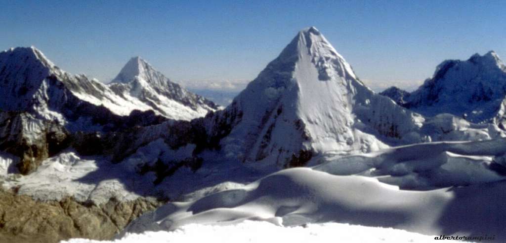
Nevado Pisco Oeste (Western Pisco) is a fine "nevado" - the Spanish word to mean "snow covered mountain" - located in the Huandoy Massif of Cordillera Blanca, Ancash region. The mountain, joined to the famous "Huandoy Group" through a high col, has two different summits: Pisco Oeste and Pisco Este. Between these ones Pisco Oeste is the easier and the lower one, even if for only 8 meters. While the summit of Pisco Este (Eastern Pisco) is rarely frequented, its lower brother is a perfect peak to climb both for skilled mountaineers and novices.
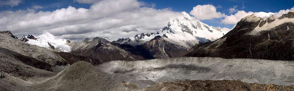
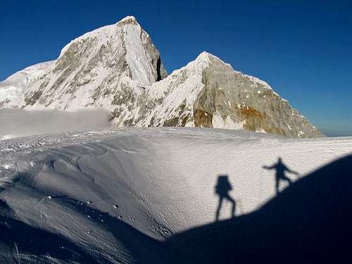
In facts Pisco Oeste Normal Route on South-West ridge is frequently attended in reason of its moderate difficulty and its beauty. It is also very popular amongst climbers to acclimatize, considering to climb successively a 6000er or to do more technical ascents. Moreover, the 360 degree summit views over the Cordillera Blanca are a must: besides the Huandoys, the impressive Chacraraju to the East, Pirámide de Garcilaso, Artesonraju and Alpamayo to the North; Huascarán to the South. Pisco Oeste was first climbed in the year 1951 by a French expedition, putting a high camp at 5300 m. on the col between Pisco Oeste and Huandoy Este. Just a curiosity: the peak took its name from the typical Peruvian liqueur, called “Pisco” from the namesake town, consumed after the first ascent to celebrate. The original name of the peak seems to be lost.
Getting There
There is a good choice of flights getting to Lima, both from Europe and North America, obviously many more from South America. "Lima Aeropuerto Internacional Jorge Chavez" is located in suburban Callao (about 12 km West to downtown).
Getting to Huaraz
Huaraz, the capital of the Ancash region and Cordillera Blanca, is a lively and bustling town located about 3000 meters above sea level, which offers several opportunities for accommodation and food, and also easily the possibility to arrange on-site transportation and trekking for people who haven't previously booked any service. Sometimes there are flights joining Lima and Huaraz, but they are not regular. At moment, the best way to get to Huaraz is a 6-8 hours trip by bus or private minibus (if you're travelling with an organized expedition). Currently, comfortable coaches provide a good transportation from Lima to Huaraz. There are six different bus companies, the best ones are Cruz del Sur, Movil Tours and Ancash Express.

|

|
Getting to Quebrada Llanganuco
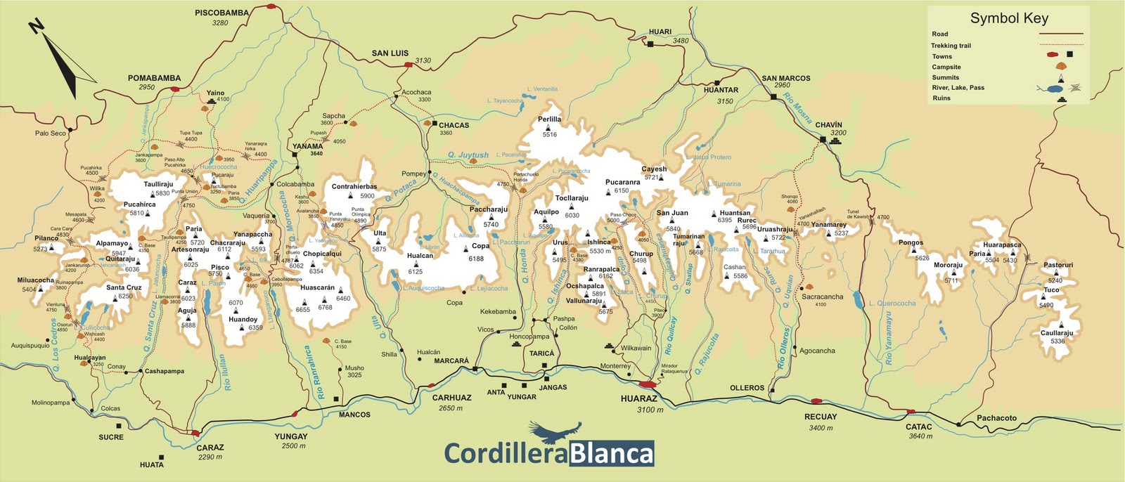
The starting point to climb Pisco Oeste is located in Quebrada Llanganuco (Llanganuco Valley), one of the most spectacular valleys in the Cordillera Blanca. From Huaraz take a "colectivo" (public bus) to the town of Yungay (1 hour), or otherwise arrange a private transportation, if you are in a group. In Yungay ask for another shuttle to Pisco Base camp in Llanganuco valley (Quebrada Llanganuco). There are two lagoons in Llanganuco: Laguna Chinancocha and Laguna Orconcoha. When you bargain with the driver make it clear that you want to go to the Pisco Base Camp, located at the first hairpin-curve at 77km, called "La Curva" or "Cebollapampa", lying 5 km. beyond the other lagoon (tourist buses usually only go to the first lake!). On the way you will stop at the park entrance gate, where you will pay the entrance fee.

Walking approach and Camps
There are different opportunities to put up your tent on the way to Pisco Oeste. As Pisco is frequently climbed, the camps are heavily used. Carry out everything you bring in and help to conserve the beautiful landscape!

|

|
- Llanganuco Base Camp or Cebollapampa 3900 m. You can camp in the meadows nearby the curve at km 77. Water nearby. During the season arrieros (mule drivers) are present at Cebollapampa offering their services. For transports to Refugio Peru (=Pisco B.C:) they charge 10$ + 5$ for each animal (one donkey can carry about 30 kg)
- Base Camp 4600 m. From the hairpin at 77 km. descent through the forest to the meadow below, cross the stream on a small bridge and head up North-West on the obvious well worn trail, leading to the wide meadow of Pisco Base Camp. 1,30-3 hours from Cebollapampa. Spring nearby. The camp sites around the three large boulders are drier than the other ones.
- Refugio Perú 4640 m. Built on a granite hill to the East of the Base Camp. 80 sleeping places, local food and beverages.
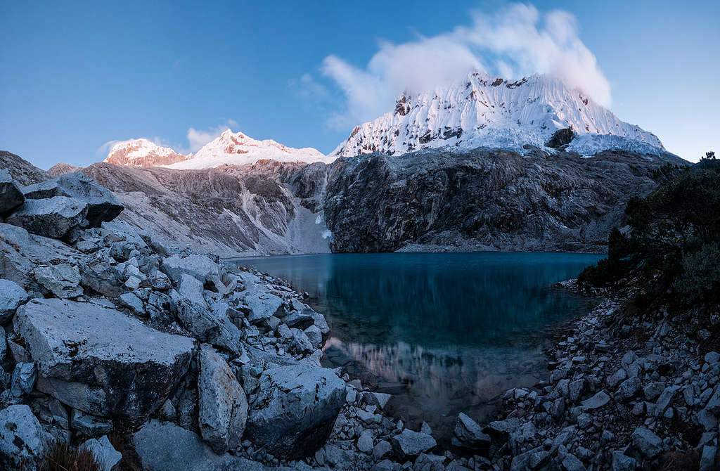
- Moraine Camp 4900 m. From the Base Camp follow the path leading to the steep side of the moraine. Climb it, getting the moraine crest, and drop down on the steep opposite side. Cross the boulder-covered toe of the glacier, following the cairns to the opposite side. Climb up the opposite moraine ridge and follow the trail heading to the Huandoy-Pisco Col, pass a first large lake and walk up to the smaller upper lake, where it is located the Moraine Camp (from 1 and a half to 3 hours from the Base Camp). The camp is situated nearby the sandy floor of an old lake.
If you are not acclimatized, plan one or two extra days in Cebollapampa (possible day hikes to Laguna 69 at the foot of Chacraraju - very recommended!! - or to the Portachuelo de Llangaganuco).
Pisco Oeste main routes overview
- South-West Ridge (Normal Route)
Difficulty: PD
First ascent: C. Kogan, G. Kogan, R. Ceninger, M. Lenoir 12-7-1951
Altitude gain from the Base Camp: 1200 m
Altitude gain from the Moraine Camp: 850 m


On the steep icy South Face of Pisco Oeste – facing the Refuge Perù – there are some technical ice-climbs:
- South Face D Climbing length: 350 m. First ascent: M. Barrand (solo) 26-7-1977
- South Face D Climbing length: 400 m. First ascent: M. Barrand, C. Bougnaud, P. Vallençant 30-7-1977
- South-East Buttress TD- Climbing length: 500 m. First ascent: R. Tuliszka, J. Mancincowski 11-8-1976
- South-East Buttress variation D+ Climbing length: 420 m. First ascent: M. Bougnaud, R. Wilson 24-6-1981
- East Face ED (50°-90°) Climbing length: 350 m. First ascent: C. Geisler, S. Gaston 1998
- North-East Ridge TD Climbing length: 300 m. First ascent: L. Apollonio, D. Baldassi, A. Orlini 20-6-1983
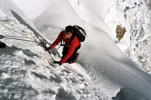
South-West Ridge Normal Route report
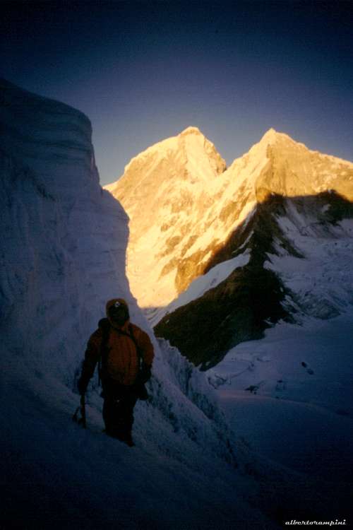
South-West Ridge Normal Route
Summit altitude: 5752 m
Difficulty: Alpine PD+, 30°- 45°, a 3 meters ice-wall near the summit
Difference in level: 1150 m. from Base Camp, 850 m. from Moraine Camp
Exposure: SW
First ascent: C. Kogan, G. Kogan, R. Ceninger, M. Lenoir 1951, July 12th
Starting point: Cebollapampa in Quebrada Llanganuco m. 3900
A fine route with low difficulties. Anyway, even if it's a non-technical route, it's not a place to learn how to climb, in reason of the serious environment, demanding respect in reason of the objective dangers, variable conditions and changeable weather. Moreover, summiting requires a good acclimatization. The Moraine Camp is a cold place, but cuts the altitude gain of about 300 meters. Otherwise, if you are well acclimatized you can start directly from the Base Camp.
|
|
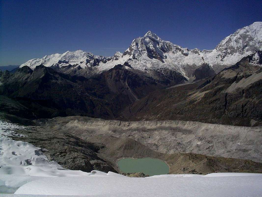
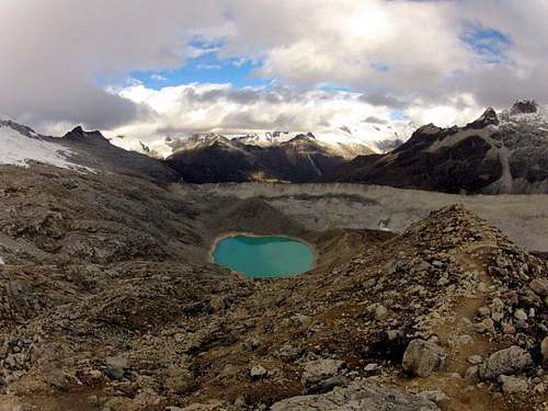
From the Moraine Camp 4900 m follow the trail (cairns) to the Huandoy Este-Pisco Oeste Col 5350 m up the moraine ridge on the right hand side of the Camp. As you will start during the night, it is advisable to check the cairned path the day before. Cross the upper granite slabs, gaining the glacier at its highest point (5150 m). Cross the first crevassed zone, heading West towards the Huandoy-Pisco Col 5300 m. From the col turn to NE and climb the gently sloping glacier along the SW ridge, negotiating some crevasses and usually a 3 meters ice-wall, before gaining the summit ridge and the top. Outstanding 360 degree view from the summit (3-5 hours from the Moraine Camp). Descent: reversing the same route - Recommended gear: rope, crampons, long axe, some pickets and 1-2 ice-screws
Red Tape and general information about Huascaran National Park
Pisco Oeste and the entire Cordillera Blanca are lying inside Parque Nacional Huascaràn, one of most spectacular mountain area in Perù, established in 1975 and acknowledged as an Unesco World Natural Heritage in 1985. Unesco Link here: Unesco info. The Huascaràn National Park is administered by the Instituto Nacional de Recursos Naturales (INRENA). An entrance fee is due. In 2016, the fee for the Huascaran National Park was 65 Soles for 7 days and 10 Soles for 1 day. Since 2011, officially nobody is allowed to climb without a Mountain Guide, except for the persons who are members of a Mountaineering Association. In this case, the permit can be obtained at the National Park Office in Huaraz, showing the Alpine Club card. Take care of nature as usual in the natural sites and particularly within the boundaries of all the natural parks. Carry out everything you bring in and help to conserve the wonderful landscape!
When to climb
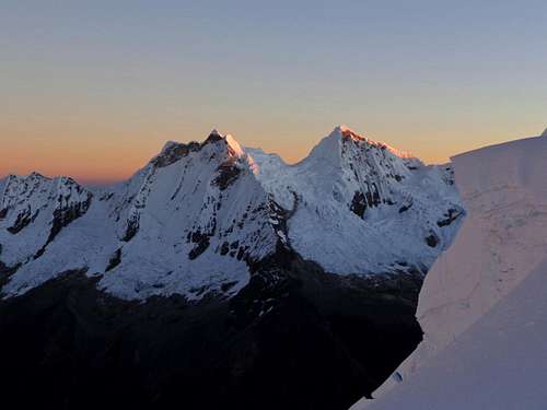
Alpamayo and Artesonraju seen from Pisco Oeste summit
The best time to climb in Cordillera Blanca is the dry season, going from middle May to the beginning of September; it's the local winter, being Peru located on the Southern hemisphere. Anyhow, still there is usually too much snow dust in May and June for the ascents, the months of July and August are more indicated. Usually the rainy season starts in early September.
Climate, Mountain condition
The climate of the Cordillera Blanca is influenced both by the dry air coming from the Western deserts and by the wet air coming from the Eastern amazonicos forests. From May to the begining of September, the Cordillera Blanca has some periods of clear weather, expecially in June and July, generally with an alternation of few days of bad weather. During these days the mountains can get some amounts of snowfall. Sometimes August may be a month of change, expecially in the second half, with possible afternoon storms. Being the "Blanca" located in the Southern hemisphere, North and East faces get good conditions first.
Accomodation
There are plenty of possibilities in Huaraz. A friendly place to stay is Edward's Inn, managed by Edward, a mountain guide.
Meteo
Guidebooks and Maps
 |
 |
 |
Guidebooks
- Classic climbs of the Cordillera Blanca - Perù by Brad Johnson, 2009 revisited edition - in English
- Escaladas en los Andes by Juanjo Tomé Ed. Desnivel, 1999 - in Spanish
- Climbs of the Cordillera Blanca of Perù by David Sharman, 1995 - in English
Maps
Alpenvereinskarte 0/3a Cordillera Blanca Nord (Perú) 1:100000
Additional images
Here: A quicky to Pisco by SP member Rgg
External Links
Parque Nacional Huascaràn
Cordillera Blanca on Wikipedia
Unesco info
Lonely Planet