
|
|
Mountain/Rock |
|---|---|
|
|
46.45000°N / 10.61670°E |
|
|
12365 ft / 3769 m |
|
|
Overview
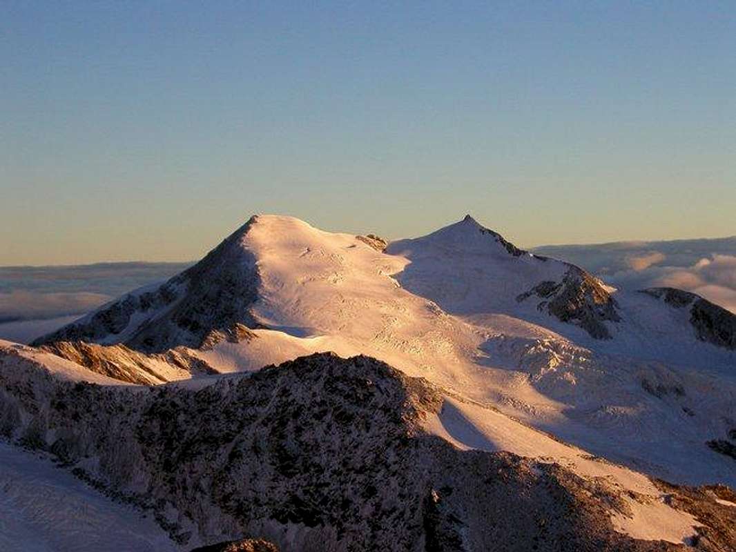
Cevedale is a mountain belonging to the omonimus group (Ortles-Cevedale) in the Italian Stelvio national park. It ranks the top three mountains of the park in height. From the peak it is possible to admire the wonderful scenario of the mountains range of that region, among which Gran Zebru' (Konig-spitze), Ortles(Ortler) and San Matteo.
The best season to alpinism activities it's between June and September: It's necessary absolutely to use the crampons and the ice-axe on the path from the refuge Guasti-Casati and the peak. It's also recommended to climb on the rope (presence of crevasses on the path). It's also usually frequented by alpinist-skiers during the Spring.
It is possible to arrive by car from Santa Caterina Valfurva to the refuge 'Ghiacciaio (glacier) ai Forni' (2.170 m.), where there is a free wide parking area. To enter the park it isn't required any permit but the only respect of it's natural rules. Be careful: the area has been during the first world war. In case you find out any old war weapon, do not touch it and call the police guards.
Getting There
FROM MILAN BY CAR: statal route "Vallassina" number 36 to Lecco and then to Colico (north side Como lake) and then Stelvio statal route to Morbegno, Sondrio, Tirano and then to Bormio (three hours). From Bormio only 12 Km to Santa Caterina Valfurva and then 8 Km to Refuge ai Forni, where is situated a free parking area.FROM MILAN BY TRAIN AND BUS: take a train in the Milan Central station destination Tirano and then a bus to Santa Caterina (4 hours).
FROM SUDTIROL BY CAR THROUGH STELVIO PASS: from Bozen (Alto Adige on the highway between Innsbruck and Verona) to Merano by main route and the by local route through Venosta Valley follow the signals to Stelvio mountain pass (2700 meters, the highest mountain pass reaching by car, open only in the summer period). From here to Bormio (3 hours and half from Bozen, Stelvio pass requires 44 bends to go up and 15 to go down). From Bormio only 12 Km to Santa Caterina Valfurva and then 8 Km to Refuge ai Forni, where is situated a free parking area.
FROM SAINT MORITZ (CH) BY CAR: go to Pontresina and then follow the signals to Bernina pass. Turn left when you look the indication to Livigno (I) through Forcola pass (open only in summer period) and then from Livigno through Foscagno pass (2200 meters, open all the year) to Bormio (3 hours). From Bormio only 12 Km to Santa Caterina Valfurva and then 8 Km to Refuge ai Forni, where is situated a free parking area.
FROM SANTA MARIA (MUNSTERTAL - CH) BY CAR: follow the signals to Giogo di Santa Maria (Pab Umbrail) on the border between Switzerland and Italy and then to Bormio (1 hour and half, border near Stelvio pass, open only in the summer period). From Bormio only 12 Km to Santa Caterina Valfurva and then 8 Km to Refuge ai Forni, where is situated a free parking area.
FROM GERMANY OR AUSTRIA BY CAR: on highways via either Innsbruck or Bregenz to Landeck and then following Staatsstraße S 13 to the italian border at the Reschenpass / Passo di Resia . There the Vinschgau / Val Venosta valley starts that represents the northern border of Ortles-Cevedale group. At Prad the Trafoi valley starts that leads either to Sulden / Solda or via Stilfser Joch / Passo di Stelvia to Bormio. From Bormio only 12 Km to Santa Caterina Valfurva and then 8 Km to Refuge ai Forni, where is situated a free parking area.
FROM PONTE DI LEGNO: through Gavia pass, dangerous route (very small) open only in the summer period. From Santa Caterina Valfurva to the Refuge ai Forni, where is situated a free parking area.
Look here for more info
NORMAL ROUTE:
From the refuge 'Ghiacciaio (glacier) ai Forni' (2.170 m.) walking trough an easy path in two hours to Refuge Pizzini Frattola (2.700 m.) and then in another hour and half toRefuge Casati (3.200 m.), where I advise anybody to sleep. From the refuge it is possible to walk through the glacier on a path that brings to the peak after about a three hours trip.
Another solution to reach refuge Casati start from Refuge Città di Milano (by telpherage from Solda/Sulden). The second day through ice lake mountain pass you arrive in about 3 hours and half to refuge Casati (be carefull, many crevasses in the part between ref. Milano and the pass).
CROSSED TO PALON DE LA MARE: It's a very nice possibility: in the same day you can continue the trip on the ridge to "Palon de la Mare" (2 hours) and come back to "refuge Ghiacciaio Ai Forni" from the Palon de la mare normal route. It belongs 5 hours from the "Mount Cevedale" peak to the refuge. If you you have some problem to complete the round trip, you can sleep in bivouac Colombo, situated on the ridge between the "Cevedale" and "Palon de la Mare" peaks.
A good idea may be to spend some days on easy mountaineering like Cevedale and Palon de la Mare and some others in the area. When you're ready for something steep, and you have the necessary experience, consider the climb to Gran Zebru. A guided climb may be an unforgettable experience for learning on ice climbing considering the technical aspects of the mountain. Mountain guides available through the information office +39-0342-935544.
Route suggested by Claude Mauguier:
From Guido Larcher hut, one must first go up to La Forcola pass (3032 m.), then climb the whole ridge leading to Cevedale II (3757 m.) sometimes called Zufall Spitze (actually the northern false summit of Cevedale II, 3700 m.), 2 km long, mainly on scree, loose rock and snow patches. The connecting ridge between Cevedale I and II is about 800 m long, and (was...) exclusively on snow/ice, with a rock outcrop halfway. This might be tricky if iced, and a bypass could then be tempted on the right (north) side on steep ice, for the southern flanc would involve a quite consequent loss of altitude + schrund crossing, due to the general dramatic diminution of glaciers.
13 peaks Tour

It's a tour that in few days without go down under 3000 meters lead you through 13 peaks of the region:
From Pizzo Tresero (m.3594) to Punta S.Matteo (m.3678)
- DAY 1 -
From Santa Canterina Valfurva (Valtellina - Italy) you go by car to Gavia pass. From here on the left side of the pass you walk through the normal route to Pizzo Tresero until Bivacco Seveso, and crossing South-West ridge on the snow (keep the left), you lead the Monte Tresero peak (m.3594 - easy passages on the rocks near the peak). Then through small rockes you lead Punta Pedranzini (m.3599): from where, without difficult passages, you arrive on Cima Dosegù (m.3560) From here you can admire the north side of Punta San Matteo! Then be carefull at the short ridge south-east (ledges to north). If the visibility is not good, keep the easy small rockes at south. To lead San Matteo (m.3678) walk on easy snow-ridge NW, (45° - use absolutely the crampons). From the peak you go down and through south side of Monte Giumella (m.3596 - easy to climb - few minutes from the path). Then go down to Colle degli Orsi (m.3304), in wich you find Bivacco Meneghello, that you can look when you are very near to it (ore 2.30-3, PD+).
From Punta Cadini (m.3524) - Monte Vioz (m.3645)
- DAY 2 -
From Bivacco Meneghello, after Col degli Orsi, you go up through West that leads on Punta Cadini (m.3524). Go down from here, you climb the easy rocks through Rocca di Santa Caterina South-ridge. You climb a small wall (few meters - II/IV level) and leaded "la Rocca" you arrive quickly on Cima di Peio (m.3549) from where, always through the ridge, you reach Punta Taviéla (m.3612). When you go down you have to climb the hardest passages on the rocks of the tour. From here to East, you arrive on Monte Vioz (m.3645), at few minutes to Refuge Mantova/Vioz (6-7-hours, AD).
From Monte Vioz (m.3645) to Monte Cevedale (m.3769)
- DAY 3 -
From refuge Refuge Mantova/Vioz you lead in 15 minutes the peak of Monte Vioz (m.3645), from where you go down to north, to pass of Vedretta Rossa (m.3405). From here you go up through the SW ridge of Palón de la Mare (m.3703), easy until the peak.
An other easy path the go down leads to Col de la Mare (m.3442), near Bivacco Colombo. You cross to Cima del M. Ròsole (m.3536) until the pass with the same name of the mountain (m.3502) from where, you arrive on the Monte Cevedale peak (m.3769), highest point of the tour. By Cevedale Normal route (look the description in the Cevedale page) you lead Refuge Casati (ore 4-5, PD).
Red tape
It is possible to arrive by car from Santa Caterina Valfurva (Lombardia - Italy) to the refuge 'Ghiacciaio (glacier) ai Forni' (2.170 m.), where there is a free wide parking area.Be carefull: the area has been theatre of battles during the first world war. In case you find out any old war weapon, do not touch it and call the police guards.
Mountain Conditions
The best season to alpinism activities is between June and September. To lead Cevedale peak it's necessary absolutely to use the crampons and the ice-axe. Is also recommended to climb on the rope (presence of crevasses on the path).Check the wheather forecast and any mountain condition at
Meteo Lombardia and Banca Popolare di Sondrio site.
Refuges of the Area
Refuge Pizzini FrattolaRefuge Casati
Branca-Martinelli