

|
|
Mountain/Rock |
|---|---|
|
|
1.4667°S / 78.8°W |
|
|
Mountaineering, Ice Climbing, Mixed |
|
|
Summer, Winter |
|
|
20571 ft / 6270 m |
|
|
Overview
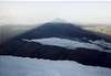
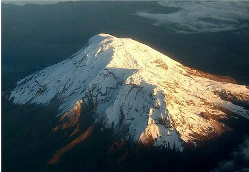
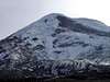
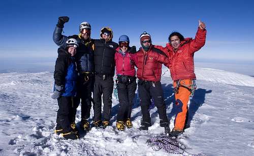
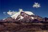
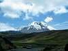
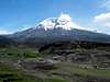
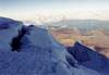
Longtime considered as the highest mountain on the planet, Chimborazo was dethroned by the Himalayan and Peruvian peaks. Nevertheless, considering the geometry of the Earth, this summit is known as the farthest point from its center (see section below for full explanation). This huge mountain is the highest point in Ecuador. It has five summits, the highest culminating at 6,270 meters (20,571 feet).
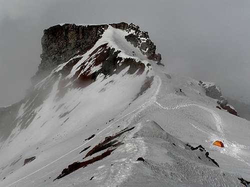
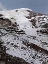
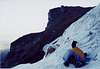
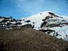
There are many routes up its slopes. The normal route is now El Castillo, but many other routes are available on the mountain
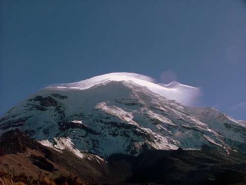
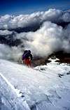
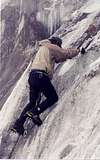
The Normal route sees many attempts all year long and is considered a class 4 climb with route finding and crevasses crossings.
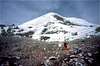
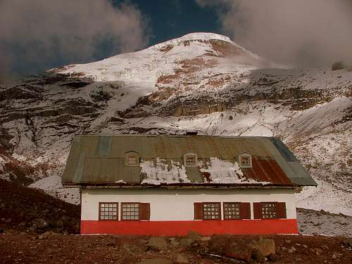
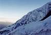
There are two refuges on the mountain, Carrel refuge at 4,800 m (15,744 ft.) and Whymper refuge at 5,000 m (16,400 ft.) where most of the parties do their summit bid from. It is a 6-9 hours climb with slopes up to 60 degrees. People usually start their climb one or two hours before midnight and return to the hut a couple hours before noon in order to avoid rock fall danger caused by sun hit on all routes.
 |
 |
 |
 |
 |
Altitude
There is some debate on the actual height of the mountain. Older sources listing the peak as 6310 meters (20,702 feet) are likely incorrect.
In 1993 members of the School of Military Survey in Newbury, United Kingdom measured Chimborazo's altitude with the use of a differencial GPS and got a measurement of 6,268 m. It is claimed they reached Cumbre Veintimilla (under foggy conditions) or the second highest summit which actually has that altitude. In a clear day Cumbre Whymper or Maxima is located in the back of it (visible from Cumbre Veintimilla only) and it can be reached after descending and traversing a couple hundred meters in east direction.
At the moment, the most accepted official height is 6270 and is probably the most accurate measurement. It also correlates well with SRTM and satellite data.
Updates for Climbing Huts
Information from JW Briggs:
IMPORTANT: As of this February 3 2021, both the Carrell and Whymper Refugios are CLOSED and you will not be able to sleep there. Apparently there is some sort of dispute with who owns or operates the huts.
On Saturdays it seems you can get some things from the kitchen inside the Carrell Refugio and the bathrooms were open at the time.
Getting There
From the new Terminal de buses Quitumbe located at the south of Quito, take any of the southbound buses to Riobamba (USD. 3,75 – 3:30 hours). From Terminal Terrestre de Riobamba take one of the several buses that go to Guaranda, but ask the driver to drop you off at Chimborazo entrance (there's a signed turnoff for the Chimborazo refuges). It is located 30 minutes after passing the town of San Juan.
La Reserva de Producción Faunistíca Chimborazo gets its name for the hundreds of vicuñas that can be seen poking around in the area. They were imported from Chile in 1980 and are a protected specie of the Andes
You can also hire a taxi cab (USD 20,00) for the drive to the trailhead, 1/2 hour away from the Whymper Hut.Starting your trip from Ambato (1 hour before Riobamba) is not advisable. You will have to take a bus to Guaranda and stop at “El Arenal” where buses passing by the trailhead aren’t too frequent and the risk of getting robbed is high. There’ve been reports of robbery lately in this area.
Once at the entrance of the park it is a matter of luck how fast/ for how much $$ you can get to the lower hut. In high season there might be pick up trucks/buses going up to pick other trekkers/climbers.
 |
 |
 |
 |
 |
Note: As January 2012, the terminal in Riobamba is under construction and the improvised terminal is a little bit of a mess. None of the buses are letting passengers off at the park entrance, including the Flota Bolivar that goes to Guaranda. However, it's possible to take a bus and get dropped off at the Reserve entrance if you don't mention it before buying your ticket to Guaranda.
Taxis from Riobamba cost USD. 35.00 one way.
Thanks Socorro for the updates!
Red Tape
Starting Nov.12 2012 nobody is allowed to climb any glaciated mountain in Ecuador without hiring an accredited mountain guide. This restriction was issued by Ecuadorian Goverment after the last fatal accidents that happened in 2012 in Illiniza Sur and Norte.
There are not fees to enter Chimborazo Reserve.
No parking fees
 |
 |
 |
 |
When To Climb
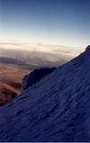
Chimborazo is climbable year round however, the best climbing months are June and July and December through early January. February through May is known for bad weather, especially in the month of April.
Make sure you start before midnight so you'll be back before 10 am at the latest, for two reasons:
First, rock fall hazard. The part of the route along The Castle, a large rock wall about one hour from the Refugio Whymper, gets dangerous around that time. Lots of small and large rocks start to fall down then from this high wall due to warming temperatures.
Passing this area (El Corredor) later in the afternoon is really running between falling rocks.
Secondly, clouds will most often roll in early in the afternoon, making route finding very difficult. As there are big areas of crevasses on both sides of the normal route, losing track can be very dangerous.
 |
  |
 |
 |
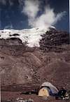
Camping
IMPORTANT UPDATE:
**** AS of JUNE 2022 WHYMPER AND CARREL REFUGES ARE STILL CURRENTLY CLOSED. ****
As I said earlier, most parties climb directly from the Whymper refuge (5,000 m / 16,400 ft.). It provides bunk-beds (4 dozens), brand new mattresses, toilets, cold water, basic food supplies, stencils, gas stove, fireplace and ... cable TV (just kidding!) .
At the moment overnight costs in Whymper refuge is USD. 15.00 a night for a bed and USD. 30.00 with meals. The refuge is partially open
You can find the same facilities and costs in the Carrel refuge (4,800 m / 15,744 ft.) as well. This refuge is completely open with 52 beds. Your climb will have to start an hour earlier, though.
What else do you need? Camping is also allowed anywhere on the mountain and some parties make a high camp to cut the summit push in two days which, I think, increases your chances to make it to the summit. The most recommendable are:
El Castillo high camp, lays in the hollow of a bowl, just a few meters beyond the rock outcrop and at the left side (north) of the Southwest ridge (the normal route). Not advisable if there’s fresh snow accumulation on the first dome. This camp can get pummeled at least by the windblast of avalanches coming from above.
Moraine camp, located 10 minutes away from Whymper refuge at 5,050 m. There’s a wide flat field in this area. Make sure you set camp away from the moraines and the Thielman glacier.
More information about the refuges here
Climbing Routes
|
Route Name |
Route Grade |
First Ascent |
Notes |
|
North Side – Las Murallas Rojas |
II |
Beltran, Campana, Carrel, Whymper (1880) |
8-9 Hours for ascent. 3900 feet |
|
North Side via the Castillo |
II |
Unknown |
8-9 Hours for ascent 3900 feet |
|
North Side via the Thielmann Glacier |
II to III |
Unknown |
40 Degree slopes. 8 Hours for ascent. 4300 feet |
|
West Face |
WI4 |
S. House 1996 |
Sections of 85 Degree mixed climbing. 3900 feet |
|
Original Route |
II |
Carrel, Carrel, Whymper 1880 |
Follows SW Ridge and Face. 8-9 Hours for ascent. 4300 feet |
|
South West Face |
III |
L. Griffin, M. Woolridge 1984 |
50 Degree and steeper sections. 1 ½ days for ascent. 5000 feet |
|
Arista del Sol |
V |
J. Anhalzer, R. Cardenas, R. Navarrete 1983 |
The hardest route put up so far. The first 2/3 of the route is entirely rock. Requires 2 days. 3300 Feet. |
 |
 |
 |
 |
Ascent History
The following is a brief overview of the history of Chimborazo ascents. I have tried to hit the highlights.
1802-French climber Aime Bonpland and German climber Alexander von Humbolt reach a height of 19,300ft before being stopped by an "insurmountable cleft".
1880-The first ascent of the mountain by Italian J.A Carrel and British climber E. Whymper via the South West Ridge.
1968-An American/German team summited the technically challenging North Ridge via the Abraspungo Glacier.
1980-In celebration of the 100th anniversary of the first ascent, a large hut was opened below the South West Ridge close to the foot of the Thielmann Glacier. This hut named Refugio Whymper is now used by a lot of ascent parties as "base camp".
1993-One of the worst accidents in the history of climbing in Ecuador occured on the upper slopes of the mountain. 13 people were caught in an avalanche high on the mountain resulting in 10 deaths.
 |
 |
 |
 |
 |
Farthest from the Earths Center???
As stated in the Overview, Chimborazo's summit is the farthest point one can get from the center of the Earth and still be on land. It is about 2160m farther from the center than Everest's summit. This is only possible because the Earth is in the shape of an oblate spheroid, i.e., it is flattened (squashed) at the poles and bulging at the equator.
Here is a diagram (based on Klenke's Excel spreadsheet). His spreadsheet can calculate the distance from the center of the earth for any point on the Earth's surface (of known elevation above sea level). If you are really into math ... here is a link to show you how this is all done: CLICK HERE

Thanks Klenke for the above graph and explanation.
Guide-Books
Ecuador: Climbing and Hiking Guide, 6th Edition, by Rob Rachowiecki and Mark Thurber, (2008)
Ecuador : A Climbing Guide by Yossi Brain. (September 2000)
Visit the Ecuador’s Map Grid System to the check the maps you may need when climbing here. This grid follows the Instituto Geografico Militar grid system. The sheet for Chimborazo is CT ÑIV C1
 |
 |
 |
 |
 |
External Links
- Ice-X Foundation
Dutch climbing foundation, supported by very enthousiastic climbers. Seven Summits on our programm (just climbed Aconcagua solo off-season). Lots of info and photos available. Site is in Dutch only yet. English version coming soon! - Chimborazo
Great video of hut and climb up some of Whymper route
seancau - Mar 10, 2016 3:07 pm - Hasn't voted
March 2016 updateRefugio Hermanos Carrel fully open (52 beds), since last year. $15/night for a bed, $30 with meals. Whymper Refugio partially open, café open during the day for visitors, the almost finished dormitory was opened for our group - it will have approx 24beds when completed. Whymper Refugio only of use when Normal Route is safe (requires snow to minimise rockfall risk), otherwise Carrel Refugio is better for taking alternative route. Only 900m distance/200m elevation between the two Refugios, max 30minute walk for anyone acclimatised. Both refugios are run by Andean Adventures. Was told no need to book in low season, but expect them to fill up in November/December/January. Our summit bid (March 9th 2016) was ruined by a lightning storm :(
climbhighest - Jun 1, 2016 2:18 pm - Hasn't voted
May 2016Completed a summit on May 25th of Chimborazo. There are really only two summits to Chimborazo: Ventimilla (6267m, 20562ft), and the Whymper summit (6310m, 20702ft). Most people only climb the Ventimilla because although the two summits are only a few hundred feet apart, altitude sickness and/or bad snows conditions between the two summits can make that additional very short trip take several extra hours. As for how to climb the mountain, there are several guide companies to choose from. I am not endorsing any of them, I will just share my experience as kindly as I can. I only got quotes from 4 companies: American Alpine Institute ($2680 for a 10 day excursion, about $1300 to just climb Chimbo); Ecuador Eco Adventures (guy named Wlady runs the company, ecuadorecoadventure@gmail.com and it was $760 for Carihuairazo and Chimbo); Andean Adventures (Run by John, andeannadventures@gmail.com less than $400); Tierra Zero Tours (Guillermo, tierrazerotours@hotmail.com about $470). I ended up using Ecuador Eco Adventures for the first attempt on May 14th. I will not bad mouth them, but they turned out to be a bad bet. Although I got mountain time, they are not run by an experienced mountaineer and did not understand the mountain conditions well enough to get you to the top and there is some sneaky stuff they did (but they gladly took my money anyways). I was not deterred, and made the second attempt with Andean Adventures. Turns out in recent years of ice melt, the normal route has become extremely dangerous due to rock fall, especially in high wind, and so is only used rarely. There is an alternate route from the Carrel Refugio that takes a bit longer, but has a higher success rate and is safer. As a result of this alternate route, Whymper hut is not used as often, and Carrel Refugio is the main lodging. Andean Adventures is the company that runs the Refugios in country. They are very professional, and always have a guide on Chimborazo. As a result they understand the mountain better than any of the others from outside the area. I got to Riobamba from Quito once using a rideshare taxi (works well if you know Spanish, costs $20 each way, takes 4.5hrs). The second time I got to Riobamba using the bus from Quitumbe, $4.70, and easy to do even if you dont speak spanish "AutoBus Directo Riobamba, Pronto!". Andean Adventures picked me up at the bus stop and took me to the Refugio (standard for guide companies to include). I did almost get mugged on the bus ride, so be diligent during all of the stops the bus makes. Earthquake did not seriously effect mountain routes. Acclimatize with one of the other glaciated volcanoes in the area. I recommend Pichincha Ruca (no guide needed, easy access from Quito), and then Cayambe (2hrs from Quito, just hire a guide when you get there).
the_avs_fan - Mar 11, 2017 9:14 pm - Voted 10/10
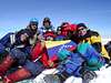
AmazingI climbed Chimborazo with Andean Adventures on Jan 27-28, 2017. I cannot recommend them enough! The owner, John, is very professional and straight-forward about every detail. I enjoyed talking with him and felt comfortable that I was choosing the right company to climb with. Their office is in Riobamba. This was one of the highlights of my trip. We got to the Veintimilla Summit at 4:45am, a little too early for the sunrise, but I was not complaining! I was just happy to make it to the top! The mountain is beautiful. It is very big, and you realize this when you see it for the first time. If you are considering going to see this mountain (or make a summit attempt) I say go for it! Andean Adventures is the best company to climb with. Why? For one, they operate the refuges on the mountain, and always have a guide above 4800M. They are the first response if an accident happens, so their guides know the mountain very well. It was the 421st time summitting for my guide when I did my hike. All in all, a special place and really quite a sight to see.
jeanpaulnoahrodney - Feb 7, 2018 6:13 pm - Hasn't voted
January 2018 Summit Attempt: Snow too dangerous NOBODY got past 19,500 feet. Whymper Refuge is CLOSEDSome updates: Whymper Refuge is closed. The lower refuge was open and was the nicest climbing refuge we have ever stayed (indoor toilets, running water, electricity, comfortable beds, and much quieter than the Cotopaxi Refuge because the ceiling are lower). The food was great but there are no lockers. We attempted the summit on the night of January 11, 2018. No one got higher than around 19,500 feet because the snow was too dangerous. A couple days later, the snow was fine and people did summit. We used Andes Climbing, based in Machachi. This (and the other mountains we climbed) was a difficult mountain for me, who is not skilled in rock climbing (my son and husband are, and it was easier for them). Be sure to use a reputable guide. On Cotopaxi, we saw a very UNPROFESSIONAL guide taking a Korean man up. Thankfully, he was not hurt.
robfrank - Mar 27, 2018 9:19 am - Hasn't voted
Looking for advice on climbing ChimborazoI'm planning a trip to Quito in late October. I would like to do both Cotopaxi and Chimborazo. I would spend a few days in Quito and then do Pichincha Ruca, then a rest day, then two days for Cotopaxi, a rest day, and then two days for Chimborazo. Does that itinerary seem feasible? Is four days in Quito and Pichincha Ruca enough to acclimate for Cotopaxi and then Chimborazo? Any recommendations for guides for Cotopaxi and Chimborazo? Thanks all for your help and comments.
fredsfo - Apr 10, 2018 12:54 am - Hasn't voted
Re: Looking for advice on climbing ChimborazoHello! I'm planning a similar trip with a friend of mine. We've hired a guide and are sort of in the discovery phase / beta gathering ourselves. We will be arriving in Quito on October 9th and have until the 18th though we plan on staying in Ecuador until the 25th. Our main goal is Chimborazo, but we also plan to attempt Cotopaxi. Our guide says that our itinerary will look something like this: https://cotopaxi-travel.com/ecuador-climb-cotopaxi-chimborazo-8days-trip.php feel free to message me if you have any questions or if you want to team up.
JWBriggs - Feb 3, 2021 11:21 am - Hasn't voted
Climbing Chimborazo and Cotopaxi during COVIDI'm curious what happened to the people in the posts from 2018. I wonder if they attempted and or summited these mountains. In any case, I did just summit these mountains. I did Cotopaxi Jan 19 then Chimborazo Jan. 23-24, 2021. IMPORTANT: As of this post, both the Carrell and Whymper Refugios are CLOSED and you will not be able to sleep there. From what I gather from the guides, there's some sort of dispute with who owns or operates it. Conversely Refugio Jose Ribas on Cotopaxi is open. That, I was surprised about. I arrived in Ecuador with the assumption that refugio was closed. Back on Chimborazo, on Saturdays it seems you can get some things from the kitchen inside the Carrell Refugio and the bathrooms were open the Saturday I was there. I spent most of the day Friday and until about 2 pm Saturday hanging around the Refugio. I had several odd experiences during that time and I camped to the right of the Carrell Refugio. Walk to the right of the building and you will see campsites ready for tents. I slept a lot and prepared for the climb the next day. The weather was terrible. Rain and sleet froze overnight and turned my tent into a chocolate-coated ice cream you get from Dairy Queen. As far as climbing the mountain, on Saturday I went up to high camp at 17,350 or whatever and setup my tent until midnight and we made a 5-hour dash to the summit. It was cold as F the last 1,000 feet. Even with a new pair of insulated Black Diamond Gortex gloves (I had purchased after my hands froze on Cotopaxi) my hands froze. We left camp too early then climbed pretty quickly. But the last 700 feet was slower and tough. We cruised the section past the rock cliffs before El Castillo comes up and joins the ridge. We blew past several of the parties who left about 15 minutes before us and never saw them again. Turns out they didn't make it much further. You can see who's climbed a mountain in technical mountaineering gear and who hasn't when it comes to these types of sections or on the descent. Anyways, we slowed down after that and the higher we got, the exponentially colder it became. At one point I took my gloves off my right hand and stuck it in my pants pocket. When I did that, I was able to regain some of the feeling and that told me that while my hand was damn cold and going toward frostbite, I had time and had caught it early enough and so far, was able to mitigate it. I powered on and we still got to the summit too early. 5:15 in the morning. It was pitch black and the clouds were on us. Quickly figuring out we couldn't see anything and the sun wasn't coming up for another hour-plus, and not wanting a repeat of Cotopaxi, where we climbed through a storm, we decided not to hangout and we went back down. The descent was uneventful and the storm never materialized. By the time I reached camp, my hands were tingling but heading the right direction. As as the other parties stumbled back, several of the guides commented on how the cold had come in so fiercely, while taking off their gloves to inspect their fingers. It turns out we got a cold weather front that rolled in for about three hours and the precipitation had held off. But the air was so wet that the cold was penetrating. That's what I learned the most. The weather and what to expect when you climb in Ecuador. That's what we had no real clue about before we arrived. Stick to climbing during the midnight hours. On this route it makes even more sense to return during frozen conditions. I thought about the next time I climb it, we leave later, even as late as 4 am. Because the snow was so firm and crunchy on the approach to high camp at 3 pm the day before, it stood to reason the snow would be firm higher up, therefore safe to travel on throughout the day. But you don't want to move slow through the rock section. It takes a good 30-45 minutes for a competent rope team to get through it. It's not technical but you have to be able to walk on mixed rock and snow and scree with mountaineering boots and crampons efficiently and in the dark. It's not a friendly-looking place to be walking beneath if it's warm and melty. I guess this is why I am surprised at the posts immediately above this from 2018 where those guys were talking about this being their first real mountaineering experience, and curious how they ended up. I'm not sure this is a route on a mountain I would learn these skills on. Contact Luis at Condor Trek if you are interested in a last-minute trip. He is pretty good with giving the info you need as far as if the refugios are open or closed and that stuff. Red Tape You'll have to figure out the red tape as you go and it's dependent on what you want to do and if you want to hire a guide. Basically you need to register at every park and they close at 2 pm. But you seem to be able to get out a bit later. But they will lock the gates on both Cotopaxi and Chimborazo. We just pitched a tent off the side of the parking lot on Chimborazo after we rolled in late Thursday night and went in the next morning. We used the day as a travel day then that night as an acclimation night because even the parking lot to the entrance is as high as the summit of Mt. Rainier. Something else we did earlier in the trip, before Cotopaxi, was spend the night at the Refugio on Pichincha. That was also a bit of and adventure (we sort of had to break in) but the night at altitude is what we needed and we managed to get it and it helped us for Cotopaxi the next night. Cotopaxi was more of a tailored experience. With the Refugio, the food and accommodations and facilities. it's different. It's like going skiing from a ski lodge. Because the refugios are closed, Chimborazo at this time was more like the experience you'd have climbing a Cascade volcano. You're more on your own with the mountain. But there's still support if you need it so it's not like climbing the Kautz Route on Mt. Rainier where you are self-sustained from as low as 3,600 feet on up. Chimborazo and Cotopaxi for that matter can each be climbed from the parking lots in a day. This is what I will do on Chimborazo next time. As far as COVID goes, I don't know why I even mentioned it in the headline. I guess to time stamp this semi trip report. It was a non factor. I've gone on seven previous climbing trips to this one during COVID and it's always been the same. Climbers are all taking it seriously and we wear Buffs. That's about it. I didn't really know what to expect before I went down to Ecuador. I had more questions than answers. But I had a plan and stuck to it and it worked (despite the off-road adventures, getting stuck and then returning the Renault Logan early due to a busted radiator). Now I know what to expect and can return anytime for a lot more climbing. The mountains are very accessible and the refugios are nice (not like the ratholes in Mexico). I will definitely be going back to do some technical climbing on Cayambe, El Atar and Illiniza Sur and I will take the family. Climbing in Ecuador is way better than Mexico. That's for sure.
Scott - Mar 19, 2021 8:15 am - Voted 10/10
Re: Climbing Chimborazo and Cotopaxi during COVIDThanks for the updates JW. I incorporated the hut closure information onto the front page and credited you with the info. Since I haven't climbed the mountains since January 2007, if there are any other important updates you think should be on the front page, let me know. Also, I think a lot of your text above can be added as a trip report if you are interesting in adding one. Recent trip reports can be very useful for people climbing the mountain.
Scott - Mar 19, 2021 8:25 am - Voted 10/10
Re: Climbing Chimborazo and Cotopaxi during COVIDUpdates on things like taxi fares, bus fares, etc. would be appreciated.
INAKI - Feb 16, 2021 12:08 pm - Hasn't voted
Chimborazo Whymper Summit 18 Jan 2021The new standard route is through El Castillo. From December to January 8, few groups were able to summit due to avalanche conditions. We had very bad weather, humid and 35 km/hr wind speed. We were the only group that made the Whymper summit that day, 0 visibility, unfortunately.
Dra125 - Nov 30, 2021 12:48 pm - Hasn't voted
Camping at Refugios Not AllowedAs of November 2021, camping is no longer allowed outside of the refugios. We were told by our guide (Edgar of Lonely Summits) that since COVID, the park has become more strict around camping and climbers are only allowed to stay in the refugio. The only place to sleep currently is at the high camp. There are large multi-person tents that have been set up for climbers and guides. FYI this significantly adds to the price for a guided trip (approximately $450/person with us bringing our own gear). I will note we did not attempt this summit or even go to high camp due to dangerous snow conditions so this is second-hand information from multiple credible guides.
heyfrederik - Jan 9, 2023 11:37 am - Voted 10/10
January 2023 UpdateI summited two days ago, solo. And stayed a full week in the park camping there, so I have all the fresh information. Transport: Couldnt be easier. Any bus to Guaranda from the main Terminal in Riobamba, for 2,5$. They will happily drop you off exactly at the park entrance if you want them to. Busses are leaving frequently, especially in the mornings. 5:45, 6:00, 7:30, 8:00, 8:30 are available for sure, bit less around noon, and then more again in the afternoons. Afternoons though are too late to go, because the park entrance currently closes at 14:00, meaning someone will be there, but unless you show up with your guide will simply not let you in anymore! I also took a taxi once and that was 30$ one-way. Hitchhiking the way from the entrance to Refugio Carrell or down is extremely easy and I never paid anything for that. If you feel like walking its 400m/8km/90-120 minutes, and there is also a footpath if you want to cut some distance. If you show up with your own car there is a parking fee now ! Cant say how much though, because I only hitchhiked up. The same busses that take you to the park will also pick you up again when you leave. Just stand on the street and keep your eyes open, you might have to wait for an hour or two though. I seriously cannot imagine someone is being robbed there, it feels extremely safe. Weather: seems to be notoriously difficult this season, from what all locals and guides told me. Lots and lots of snow, almost no clear days at all. There have been recent avalanche fatalities, at least from my own research. For the seven days before my summit attempt, success rate was 0% due to weather, despite many parties trying. Camping: As of now, you are allowed to camp, but only on the official "campsite" (no facilities, except little stream for water) next to Refugio Carrel. The refugio itself is fully open currently and used by climbing parties. Refugio Whymper on the other hand is completely out of service still. Officially you need to apply for a kind of permit/authorization for camping or show a reservation for staying at Refugio Carrell. Officially you cannot show up at the park entrance and say "I want to camp there" or "I want to stay at Refugio Carrell" without an existing reservation. Inofficially - except for the guys/girls at the park entrance - no one cares about anything. I do not recommend anything here, but I think its best to just tell them at the door that you want to do some day hiking. Seriously: if youre in, youre in. You have to register/check-in with your passport though in any case and they will also double check if its yours by asking you questions about it, which is ridiculous. Even more so when you realize that you have to check-in but never have to check out. Besides the official allowed campsite I would also recommend staying at the Laguna which is around the corner from the closed Refugio Whymper, or at the described El Castillo High Camp if your acclimatization is spot on. From conversations I had you can also show up at the official "High Camp" which is on the normal route at 5350m and sleep/eat there before your push. Climbing: the former, shorter route is almost abandoned, but not completely. It should still be safe at night/when cloudy. Almost everybody is using the longer route on the ridge now though, and so did I. Currently there is plenty of snow down to Refugio Carrell, but the actual glacier starts at 5600. I climbed solo and without a guide, which is entirely possible, if someone else is considering that (definitely not recommended though). Dont worry about anyone even looking strange at you summiting without a guide. After me two parties successfully summited too and especially the guides were super laid-back and friendly. On the glacier stick to a line 10-20m left of the highest point of the ridge and keep your eyes open for crevasses, which are there, but easy to navigate. Its 600m of altitude to the first summit with a relatively steady incline of maybe 40-45°. Then just go straight towards the true summit (you have to descend maybe 30m or so though), then its done.