
-
 44688 Hits
-
 88.91% Score
-
 28 Votes
|
|
Mountain/Rock |
|---|---|
|
|
34.91780°N / 111.7503°W |
|
|
7122 ft / 2171 m |
|
|
Wilson Mountain Overview

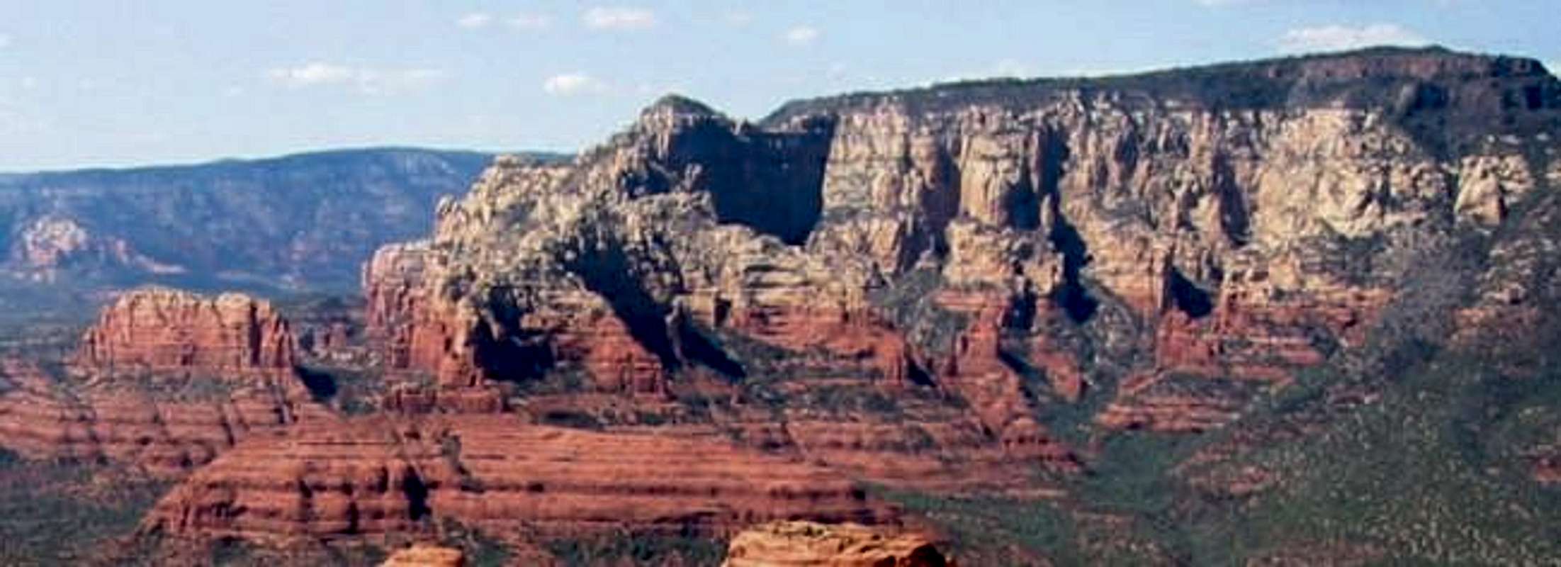
Wilson Mountain is a huge mountain north of Sedona in red rock country. It is also the highest point in the whole area. The mountain looks over Sedona, and the surrounding canyons. It also forms the southwestern side of Oak Creek Canyon. The top of the mountain is about one mile wide by 2 miles long.
 The tiny summit of Wilson Mountain
Thanks to brianhughes for pointing out that the actual summit is a really neat little rock outcropping.
If you want a really neat hike through one of Arizona’s most beautiful areas this hike is a must. From the top you can see the San Francisco Peaks by Flagstaff, and it overlooks the whole red rock country of Sedona. To make this hike even more worth it, hike about one mile more to the edge of the mesa were it overlooks the backside. There are many canyons throughout this area and in my opinion it's the prettiest side of the Sedona area.
 |  |  |  |  |
Getting There

From the intersection of Route 89A and Route 179 (The “Y”) take ALT 89 north for 2 miles until you reach Midgley Bridge. Midgley bridge is a very large bridge. There is a parking lot and picnic area to the left right after you cross the bridge. The trail head is in the northern part of the parking lot. From Flagstaff drive south on US 89A, 22 miles until you reach Midgley Bridge. The Picnic area is off to the right before you reach Midgley Bridge.

From the intersection of Route 89A and Route 179 (The “Y”) in Sedona, drive 5.3 miles north to the well signed Encinoso Picnic area on the left (west) side of Route 89A. Parking is available in the picnic area.
 North trail red, South trail Black. Thanks to Nadar for this Map.
Oak Creek Canyon Overview
 Oak Creek Canyon with San Francisco Mtn. in the distance.
I have decided to add this section to give the users on this site more of on option of hiking possibilities in this area then just Wilson Mountain. Also Wilson Mountain makes up the south west side of Oak Creek Canyon. The canyon continues up north from Wilson Mountain as it cuts into the Colorado Plateau.
Oak Creek Canyon is a very popular crowded area. Outside of the Grand Canyon this might be the most touristy place in AZ. Most people come here to go swimming in Oak Creek. HWY 89A runs right through it at the bottom near the creek. Through here there is a plethora of hiking that can be done. Some trails can be very busy and others are hiked very seldom.
Oak Creek Canyon is one of the few canyons that the trails start at the bottom of the canyon and you hike up to the top and back down.
 Oak Creek Canyon Oak Creek Canyon |  |  Mitten Ridge Mitten Ridge |
 Mitten Ridge Mitten Ridge |  |
Red Tape
There is a red rock pass that cost $5. You can get one at the trail head in a vending machine. For more information on the pass go to redrockpass.com Campsites do close during the winter, and during the summer they cost about $7 per night.When To Climb
This mountain can be climbed any time of the year. There may be snow on top in the winter. If there is, in-step crampons are recommended but not required. It may be too hot to hike in the summer months, so spring and fall are the best months to climb it.go to sedonaweather.com for Sedona's weather.
Camping
There is camping up Oak Creek Canyon. Many of the camping areas have camping fees, which is about $7 per night. The free camping areas are right next to the highway and are not desirable.Mountain Conditions
To see Sedona's Weather go to Sedona's Weather |  |  |  |
Views from Wilson Mountain
 |  |  |

The Colorado Plateau Rim Country
Wilson Mountain sits on the edge of the Colorado Plateau and is connected to it by a pass. The elevation of the rim is roughly 7,000 feet and drops to about 4,000 feet. This wild and beautiful area is full of red and white cliffs and canyons. Some of the largest canyons in the area are Secret Canyon, Longs Canyon, Oak Creek Canyon, and Boyant Canyon. Among them there are many others. There are 2 main ways of getting to the rim. One is to hike up the A. B. Young Trail in Oak Creek Canyon. The other is a 28-mile drive on a FS road.From Downtown flagstaff take Route 66 out towards I-40 to Woody Mountain Rd. Take Woody Mountain Road till it forks. From the Fork take a left and keep going till you reach a gate. Park here. You can then hike up to the lookout tower, or hike south on old roads for about a mile. This will lead to the rim where the views are breathtaking. From here you will see the backside of Wilson Mountain, the entrance to Secret Canyon, and the whole rim.
 |  |  |  |  |
Arizona 20-20 Challenge
Yes Arizona has it's own little challenge just like other states do like the Colorado/California 14ers, Idaho 12ers, or even doing all the State High points.Arizona's Challenge is the 20 highest and the 20 deepest. What this means is the 20 highest mountains that are not on protected areas and has a trail to the summit and the 20 deepest canyons with the same criteria.
The mountains all have an elevation gain of at least 1,000 feet. The listing of the Peaks and Canyons are yet to come.
For more information go to Arizona's 20-20 Challenge.
Oak Creek Canyon is the 4th deepest canyon in Arizona. If you hike up the Wilson Mountain Trail then you can complete one of the 20-20 challenge hikes and bag a peak at the same time.
| Mountain | Canyon |
| Humphryes Peak | Grand Canyon |
| Mount Baldy | Tuckup Canyon |
| Escudilla Peak | Paria Canyon |
| Kendrick Peak | Oak Creek Canyon |
| Webb Peak | Jumpup Canyon |
| Heliograph Peak | KP Canyon |
| Charicahua Peak | Salome Canyon |
| Flys Peak | kanab Canyon |
| Showshed Peak | Secret Canyon |
| Miller Peak | Jacks Canyon |
| Wrightson Peak | Bear Wallow Canyon |
| Monte Vista Peak | W. Clear Canyon |
| Blue Peak | Fossil Springs |
| Mount Elden | Havasu Canyon |
| Bill Williams Mountain | Long Canyon |
| Carr Peak | Hack Canyon |
| Mount Lemmon | West Fork |
| Clark Peak | Sycamore Canyon |
| Sentinal Peak | Wet Beaver Canyon |
| O'Leary Peak | Agua Fria Canyon |
External Links
- Coconino National Forest
- Coconino National Forest Recreation Page
Camping, Hiking, and permit information.
- Coconino NF: Wilson Mountain trail information
Detailed access information for the Wilson Mountain trail.
Jeff12633 - Dec 30, 2006 7:33 am - Hasn't voted
Closed due to fire!Sadly, both the North and South Wilson Mountain trails (along with several other beautiful trails in lower Oak Creek Canyon) have been closed since June, 2006 due to a big fire that charred most of the canyon side of Wilson Mountain. Last I heard from the Red Rock Ranger District, there was no work on when they thought the canyonside might be deemed stable enough to allow reopening of the trail. For info on trail closures in the canyon, call them at (928) 282-4119. The Coconino National Forest web page says nothing about the closures.