
|
|
Mountain/Rock |
|---|---|
|
|
47.80130°N / 123.71094°W |
|
|
Jefferson |
|
|
Hiking, Mountaineering, Aid Climbing, Scrambling |
|
|
Summer, Fall |
|
|
7969 ft / 2429 m |
|
|
Overview
Mount Olympus is the highest point of the Olympic Mountains, and as such could be considered the crown jewel of that range. The peak has major significance to mountaineers, both locally and nationally. The mountain is attempted by many summit parties each year, yet the average success rate is considered low largely due to the peak being located in the most precipitous region of Washington, having a long approach, and having a variety of difficult terrain to traverse. Despite these aspects, or perhaps because of them, those who successfully summit Mount Olympus know it is a major accomplishment to be proud of.
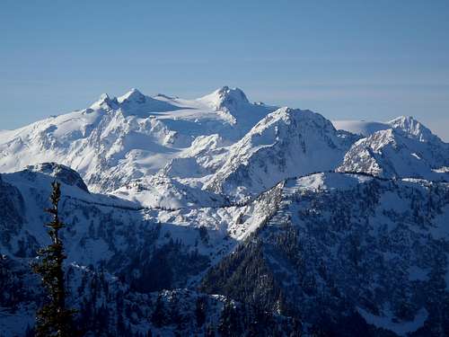 Mount Olympus, as seen from the northeast (Dodger Point)
Mount Olympus has the distinction of appearing on multiple major peakbagging lists. First and foremost, Mount Olympus is the highest point in Jefferson County, and the 10th-highest county highpoint in Washington. Mount Olympus is also the third-most isolated peak in Washington, located 108 miles from the nearest higher ground and one of only three peaks in Washington with over 100 miles of isolation (behind only Mount Baker and Mount Rainier). Mount Olympus is the highest point of the Olympic Wilderness Area and the highest point of Olympic National Park.
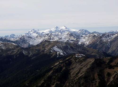
 Third-Most Isolated Peak in Washington
The mountain requires over 5000' of elevation gain by its shortest route, one of only 12 Washington County Highpoints (CoHPs) to do so. The mountain is one of only seven "Ultra" peaks (i.e. mountains with over 5000' of prominence) in Washington. The mountain is also considered one of the 20 most technically difficult county highpoints in the lower 48 States, also known as "Apex" peaks. These aspects make the mountain only one of ten total "Triple Crown" county highpoints in the lower 48 States. "Triple Crown" county highpoints are those with at least 5000' of gain, at least 5000' of prominence, and on the "Apex" list of most technically difficult peaks.
 As Seen From Another CoHP Requiring Over 5000' Gain (Gray Wolf Ridge)
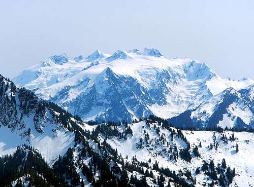
Despite being a significant mountain both regionally and nationally, few people ever even see Mount Olympus. The mountain is located towards the west-central region of the Olympic Mountains, surrounded by other hills and peaks. These peaks also obstruct views of Mount Olympus from every major city on and around the Olympic Peninsula. The best places to see the mountain, outside of its own approach, are from atop other nearby peaks and ridges in the Olympic Mountains, or away from shore along the Pacific Ocean.
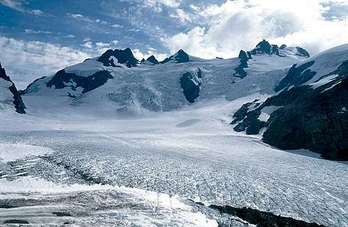
But even from these favorable viewing locations, Mount Olympus is commonly covered with clouds and being hit by storm systems. The standard approach mostly follows the Hoh River Trail, which traverses through the Hoh Rainforest. This is significant because the Hoh Rainforest averages 141 to 165 inches (360 to 420 cm) of precipitation per year, which when it reaches the upper slopes of Mount Olympus is usually in the form of snow. The mountain also supports six active glaciers. Weather and conditions along the summit approaches change frequently, making many summit attempts (and pre-planning for such attempts) fail before they even truly begin.
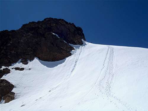
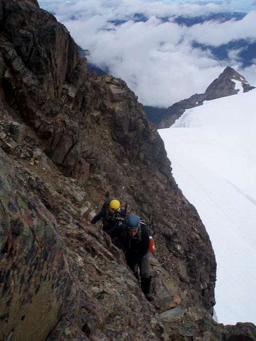
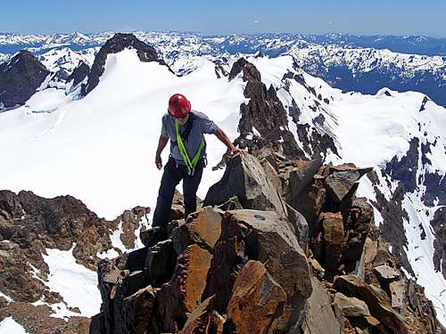 Exposed Summit Ridge Of Mount Olympus
Historical Background
The local Native American name for the peak was Sunh-a-do. Mount Olympus was first given a European name, "El Cerro de la Santa Rosalia" (The Hill Of The Holy One Rosalia), by Spanish explorer Juan Perez during 1774. It is claimed that this was the first geographic feature located in what is now Washington State which was given a European name.
However, the peak was given another name four years later on July 4, 1778. British explorer Captain John Meares gave the mountain its present name of "Mount Olympus" in reference to the home of the Gods in Greek mythology. After seeing the mountain, Meares was quoted as saying, "For truly it must be the home of the Gods." The name chosen by Meares has remained in use ever since his declaration.
The first serious summit trip for Mount Olympus was made by three members (Nelson E. Linsley, Bernard J. Bretherton, and John Danton) of the Olympic Exploring Expedition in 1890. That team reached the summit of nearby "Athena II" on September 22 of that year. Then, during 1899, a summit attempt was made by Jack McGlone, who reached the summit of the East Peak of Mount Olympus. Then, on July 17, 1907, a team comprised of Belmore H. Browne, Walter G. Clarke, Will Humes, Hershel C. Parker, and Dewitt "Dewey" Sisson reached the summit of the Middle Peak, thinking it was the true summit but unfortunately later realizing it was not. Less than one month later, on August 13, a group of 11 people led by Lorenz A. Nelson of the Mountaineers Club made the first successful ascent of the true summit (West Peak) of Mount Olympus.
 True Summit (West Peak) Of Mount Olympus
Getting There
FROM PORT ANGELES, WA:
-> Drive west, and then south, along Highway 101.
-> After ~69.5 miles along Highway 101, turn left onto Upper Hoh Road.
NOTE: The intersection of Upper Hoh Road occurs ~13 miles south of the city of Forks.
-> After ~18 miles along Upper Hoh Road, reach the parking lot for the Hoh Visitor Center and Hoh River Trail. Follow the signs for overnight parking, or ask a ranger about overnight parking availabilities.
FROM OLYMPIA, WA:
-> Drive west along Highway 101.
-> After ~six miles, continue straight/left onto Highway 8 West.
-> After ~21 miles along Highway 8, the road name changes to Highway 12.
-> Continue following Highway 12 for ~20.7 miles further, until reaching the city of Aberdeen.
-> Continue driving straight onto Highway 101.
-> After ~3.7 miles, veer right to remain on Highway 101 through the city of Hoquiam.
-> After ~90.7 miles along Highway 101 from Hoquiam, turn right onto Upper Hoh Road.
NOTE: The intersection of Upper Hoh Road occurs ~21 miles north of Kalaloch Beach.
-> After ~18 miles along Upper Hoh Road, reach the parking lot for the Hoh Visitor Center and Hoh River Trail. Follow the signs for overnight parking, or ask a ranger about overnight parking availabilities.
For those people traveling from the metropolitan areas on the east side of Puget Sound (such as Seattle and Everett), if ferries are used and under normal ferry conditions, the one-way drive to Hoh River Trailhead is ~5-6 hours.
Standard Approach
With extremely few and rare exceptions, the standard approach for Mount Olympus originates at the Hoh River Trail.
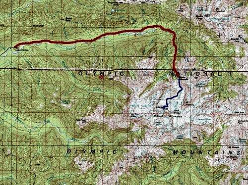 Basic Route Map
FROM THE HOH RIVER TRAILHEAD:
-> Follow the Hoh River Trail for 17.5 miles to Glacier Meadows.
NOTE: Several slide areas and washouts have damaged the trail during the last two miles to Glacier Meadows. Use extra caution for each of these areas. Please contact the Hoh Visitor Center for current conditions.
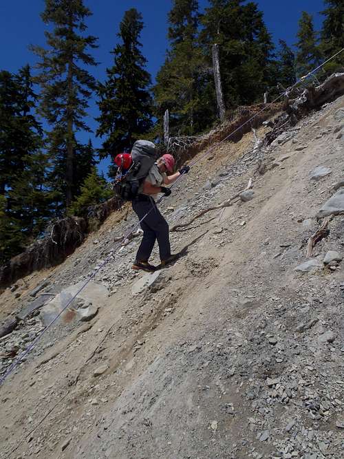 Descending Major Slide Area Along Trail
-> Sign the Climbers Register located at the ranger yurt stationed at Glacier Meadows, before proceeding with any further climbing trip.
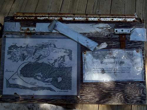 Climbers Register
-> From Glacier Meadows, there are two main options to reach the Blue Glacier:
OPTION #1: Follow the Terminus Primitive Trail south for 0.5 miles until reaching the lower end of the Blue Glacier at ~4800' elevation. This route option requires much longer glacial travel than the alternate option (see below).
OPTION #2: Follow the Blue Glacier Primitive Trail southeast for 0.7 miles until reaching the lateral moraine of the Blue Glacier. This route option is used by most summit teams, although the lateral moraine is extremely steep, loose, and contains rockfall danger.
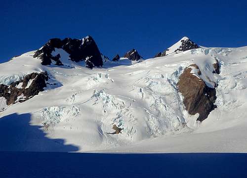
-> Once on the Blue Glacier, traverse southwest across the glacier until below the steep eastern slopes of Snow Dome.
 Looking Across The Blue Glacier Along Standard Approach
-> Ascend the steep eastern slopes of Snow Dome until at its wide open gentle-sloped mountaintop.
 Ascending Snow Dome
-> Gradually ascend south from Snow Dome.
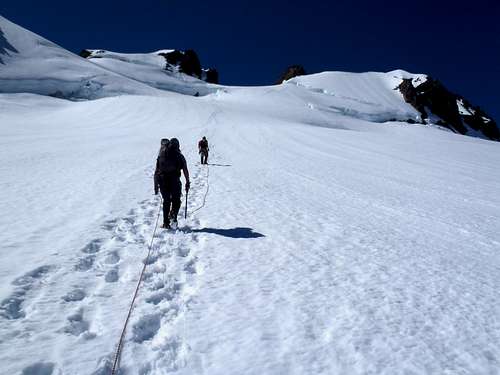 Traversing South From Snow Dome...
There are several options from Snow Dome:
OPTION #1: Most summit teams use the "Crystal Pass" route. From Snow Dome, the route first ascends to Crystal Pass, then crosses over the pass, then traverses behind (immediately south of) Five Fingers Ridge, then over the false summit, and finally ascending the true summit (West Peak) block.
OPTION #2: Some summit teams ascend south from Snow Dome towards the saddle connecting the false summit and true summit (West Peak). This route variation is nicknamed the "Fourth of July" route, although bergschrunds and crevasses typically make this route option impassable by late June during most normal snow years.
OPTION #3: A few summit teams ascend south from Snow Dome towards the eastern slope/saddle of the false summit, then traverse over the false summit to reach the true summit (West Peak) block. This route variation is nicknamed the "Early Summer" route, and as such considered as only an early season route due to bergschrunds and crevasses typically making this route option impassable by late June during most normal snow years.
OPTION #4: A few summit teams ascend south from Snow Dome directly towards the West Peak. This route variation is nicknamed the "Autobahn" route and directly ascends the north ridge to where it meets the north rockface of the summit block. This is considered a very early season route, due to bergschrunds and crevasses opening up sooner there than other areas.
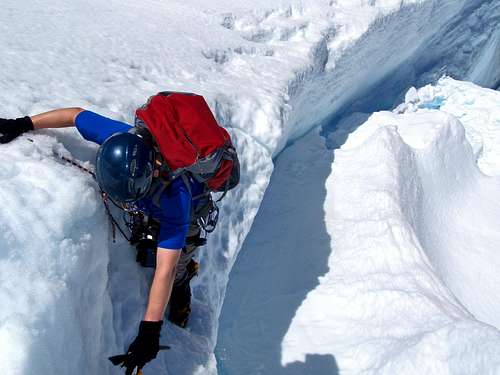 Example Of Bergschrund Complicating Routes
NOTE: As a general rule, and for safety reasons, the Olympic National Park recommends OPTION #1 (Crystal Pass) as the standard route for potential summiters to use. The Crystal Pass route is longer than the other route options listed above, but is generally considered a safer option during most of the standard climbing season for Mount Olympus.
-> The standard route for the true summit (West Peak) block is considered by most people to have Class 4 (scramble) difficulty on loose rocky ramps.
 Summit Scramble
NOTE: Other possible summit options exist that have more solid rock to climb but also steeper slopes (i.e. rockfaces) and more exposure. These routes mostly range between Class 5.4-5.6 difficulty.
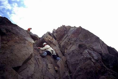 Example Of Summit Rock Climb (Alternate Option)
------------
A few mountaineers might be strong enough and have enough time to summit all three major peaks (West Peak, Middle Peak, and East Peak) during one trip. Most of such climbers, if starting from Glacier Meadows rather than Snow Dome, choose to go over Glacier Pass rather than Crystal Pass. However, this is a very long, time-consuming route which is not accomplished by many people.
Red Tape
Mount Olympus is located within Olympic National Park. As such, park passes and backcountry (overnight) permits must be purchased. Please contact the Hoh Visitor Center or Olympic Wilderness Information Center for current fees, requirements, camping reservations, and trail/route conditions:
HOH VISITOR CENTER: 360-374-6925
OLYMPIC WILDERNESS INFORMATION CENTER: 360-565-3100
-> Bear wires are available at some campsites along the Hoh River Trail. Please contact the Hoh Visitor Center or Olympic Wilderness Information Center to find out which sites have bear wires. Bear canisters are always advised, but are required for any campsites that do not have bear wires.
-> There are several major slide areas that have severly damaged/disrupted the Hoh River Trail, occurring within the last two miles to Glacier Meadows. These areas are considered dangerous to some people, and require extra caution to be used. Please contact the Hoh Visitor Center for current trail conditions.
-> The standard approaches for Mount Olympus require descending a steep lateral moraine to the Blue Glacier. This moraine is comprised of very loose dirt and rocks. Rockfall and injuries are very common. Use extra caution, both for the descent and ascent of this slope. It is highly recommended to traverse this slope one person at a time, due to the possible rockfall danger.
NOTE: Some people consider this moraine the "crux" section of the standard summit approaches, moreso than the summit block of the mountain itself.
-> The Blue Glacier has numerous dangers for which to use extra caution, including crevasses, bergschrunds, icefalls, and seracs.
 Blue Glacier Icefalls
When To Climb
The standard summit season typically lasts from late June through early September, although depending on conditions might last from mid-Spring through mid-Autumn. Winter summit attempts are rarely attempted (and rarely successful) due to the long approach, unpredictable weather, and high avalanche danger.
 |
 |
 |
 |
Camping
Established campsites are located along the Hoh River Trail. Please check with the Hoh Visitor Center if there will be any availability or reservation issues at the time of visit.
A majority of climbing parties begin summit attempts from campsites at Glacier Meadows. This is the recommended campsite for most summit parties.
Some summit parties with extra time (and strength) might opt to camp atop Snow Dome to potentially create a shorter summit day, although few choose to do so due to carrying traversing all gear across multiple steep slopes and glaciated terrain to reach that location.
A few summit parties might opt to camp below Glacier Meadows at an established campsite such as at Elk Lake or Martins Creek, although this is generally not advised because it would require a longer summit day (than if starting from Glacier Meadows) and potentially require traversing across dangerous slide areas along the Hoh River Trail during pre-dawn (or post-dusk) darkness.
------------
Many summit parties usually use one of two plans, for camping prior to a summit day:
OPTION #1: Hike 17.5 miles to Glacier Meadows in one day, and then the final 4-5 miles (one-way) to the summit the second day.
OPTION #2: Hike 9.0 miles to the Olympus Ranger Station campground or 10.4 miles to the Lewis Meadows campground (or a higher campground) the first day, then hike the final short mileage to Glacier Meadows the second day, and then the final 4-5 miles (one-way) to the summit the third day.
Weather and conditions can greatly influence number of days required and where to camp. Please plan accordingly and obtain up-to-date reports prior to any potential summit trip.
Standard Gear
-> Trekking Poles
-> Ice Axe
-> Helmet
-> Climbing/Glacier Rope
-> Crampons
-> Rock Climbing Equipment (Cams, Nuts, Slings)
-> Glacier Goggles/Sunglasses
-> Sunscreen
-> Windbreaker Jacket
-> 10 Essentials
-> Common Sense
 |
 |
 |
 |
External Links
RECOMMENDED MAPS:
-> Green Trails Map #133S: "Seven Lakes Basin/Mt Olympus Climbing"
-> Green Trails Map #134: "Mount Olympus, WA"
RECOMMENDED BOOK:
-> "Climbing Washington's Mountains" by Jeff Smoot
RECOMMENDED VIDEOS BY SUMMITPOST MEMBERS:
-> Video By "Redwic"
-> Video By "Gimpilator"
ORIGINAL SUMMITPOST CLIMBERS LOG DATA
Due to a SummitPost glitch, the original Climbers Log entries that were entered for this Mountain Page prior to July 25, 2011, were deleted from the website. There is a cache containing many of those old records which the website administrators are hoping to retrieve so the old Climbers Logs can be seen by others. They apologize for the inconvenience.
All people who have previously signed the Climbers Log for this mountain, but whose entries were deleted as part of the website glitch, are greatly encouraged to re-enter their Climbers Log information as best as can be recalled by the individuals.