
-
 123653 Hits
-
 97.27% Score
-
 67 Votes
|
|
Mountain/Rock |
|---|---|
|
|
37.96670°N / 105.5847°W |
|
|
14294 ft / 4357 m |
|
|
Under New Ownership
This page was transferred to me by long time member Alan Ellis, who acquired this page from former member Aaron Johnson. It was his generosity which made my ownership of this page possible and I would like to send many thanks to Aaron for his years of service to Summitpost.
Overview
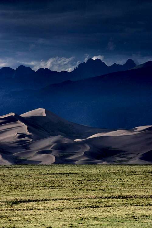
Sunset at Great Sand Dunes National Park with Crestone Peak's twin summits in the distance.
Crestone Peak is Colorado’s 7th highest mountain, and one of the most challenging fourteeners to climb. Although not the highest of the Sangre De Cristo range, Crestone Peak is clearly the reigning monarch in terms of character. For those who have climbed it, it is often referred to as “The Peak.” Among the last of the fourteeners to be scaled, along with Crestone Needle, this remote and rugged mountain was once thought impossible to climb. The easiest route is not the shortest or most direct. 800 feet of elevation must be lost and regained, another 2,000 feet must be climbed up the sustained Red Couloir to the summit, and all climbing is rated at least Class 3. Considerable climbing experience is recommended before attempting this formidable mountain.
Crestone Peak has two summits, both equal in power, each the highest point in their respective Saguache and Custer counties. The western summit is 34 feet higher. At one time, there was considerable conversation as to which summit should qualify as THE top, despite the higher western summit’s elevation. However, the controversy is now over as the western summit is inarguably the highest. When you reach the summit, you can be your own judge, and for some this is a matter best left between you and the mountain.
Adding to the difficulty of the climb is getting there. The Crestone group of mountains is one of the more difficult to reach from any direction. Early in your research you will find a great commitment is required to claim Crestone Peak or any of its lofty neighbors. Go prepared for a challenge and the experience of a life time!
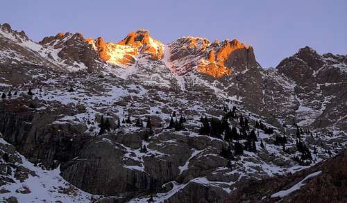 Crestone Peak at sunrise
Getting There
The following instructions are referrenced from Gerry Roach's "Colorado Fourteeners: From Hikes to Climbs"
The route to Broken Hand Pass
From Westcliffe, Colorado: Drive southwest on highway 69 about 4.5 miles to Colfax Lane (CO119) where there is a Forest Service sign. Turn right (south) and go another 5.5 miles until the road ends, then turn right (going west) on South Colony Road (Forest Service Road 120) for 1.5 miles where there is a fairly large parking lot on the right. Low-clearance vehicles can park here but 4WD vehicles can continue for another 2.6 miles to the upper gate and parking lot (30 vehicles) located approximately a half-mile past the Rainbow Trail marker. The road is closed permanently at the upper gate, at which point it's a 4.5 mile hike to South Colony basin. Follow the old road for another 3.5 miles until the road ends, crosses a small bridge and turns into a trail where the road used to end (but permanently closed in 2010). Upon arrival at lower South Colony lake, the trail forks and a small wooden sign (photo) will greet you. The sign says, "Crestone Needle Standard Route," with an arrow pointing to the left. Take the left fork to begin the approach to Broken Hand Pass and eventually Crestone Peak. Take the right fork if looking for a campsite in South Colony Basin.
SOUTH COLONY ROAD UPDATE (MARCH 2010): SOUTH COLONY ROAD IS NOW PERMANENTLY CLOSED APPROXIMATELY 2.6 MILES PAST THE LOWER PARKING LOT (ONE-HALF MILE PAST THE RAINBOW TRAIL MARKER). AT THE CLOSURE POINT, THERE IS A NEW GATE AND PARKING FOR APPROXIMATELY 30 VEHICLES.
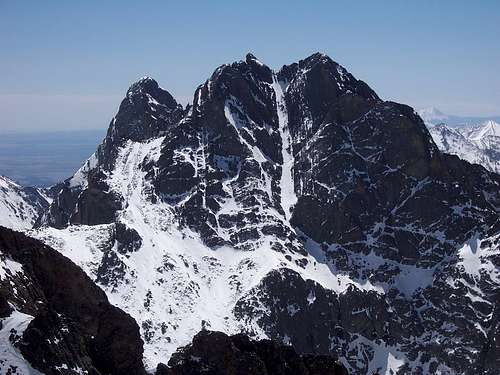
Crestone Peak from the north in September. Photo by LarryV
SPANISH CREEK TRAILHEAD
This lengthy, remote approach is used to access Crestone Peak from the west and climb the mountain via the Northwest Couloir and other northern routes. Kit Carson Peak can also be approached from here. The trail character should be considered primitive. Route finding and bushwacking may be required.
From the north, go 13.8 miles south on Colorado 17 from the junction of US 285. From the south, go 16.8 miles north on Colorado 17 from the junction of Colorado 112 in the town of Hooper. A half mile south of Moffat, turn east onto a paved road, driving 11.8 miles east to the Baca Grande Chalets Grants. See the RED TAPE section.
Turn south and follow Camino Baca Grande through the subdivision, crossing Crestone Creek (.8 mile), Willow Creek (2.2 miles), where the road becomes dirt, and on to Spanish Creek at 3.6 miles. Parking and the beginning of the trail are on the north side of the creek.
COTTONWOOD CREEK TRAILHEAD
To find the trailhead, leave Colorado state highway 17, 0.5 miles south of Moffat and head straight east (Road T) toward the town of Crestone. Just prior to the road turning north (left) into Crestone, turn south (right) into the Baca Grande Chalets Grants subdivision (there is a large sign) and follow the Camino Baca Grande road as it initially curves left (paved then dirt) through the subdivision for about 5.4 miles. When the road ends at a “T” intersection, turn left, pass a large water tank (in 0.1 miles) on the right, before the road passes through an indistinct meadow (0.2 miles) with the unsigned trailhead on the left. Park in the few spaces on the right side of the road in this meadow and find the trailhead going into the trees and uphill initially on the north side of the meadow (left side of the road) prior to the trail heading up the valley along the north side of Cottonwood Creek.
This trail is not in the best of shape and downed trees should be expected. The road crosses Cottonwood Creek shortly after passing through the meadow. If you cross the Creek, you have passed the trailhead. There is a Forest Service sign that addresses trail monitoring equipment just before the road crosses the Creek. The trail is not located anywhere near that sign. Do not pass over Cottonwood Creek and only park in the meadow since all the land along the road is private property. The landowner allows PARKING IN THE MEADOW ONLY. There is NO CAMPING at the trailhead parking area. (Directions courtesy of Dan Bereck)
Route Options
STANDARD ROUTE FROM SOUTH COLONY LAKES TRAILHEAD
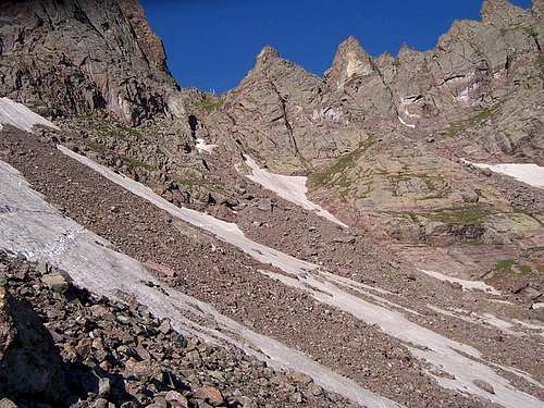
From lower South Colony Lake, the trail gradually climbs and switchbacks up rocky slopes and leads to Broken Hand Pass, the saddle between Broken Hand Peak and Crestone Needle. For some, this is the most arduous part of the day. The ascent to the pass is on steep loose scree, talus and hard packed dirt, the result of heavy foot traffic over the years.
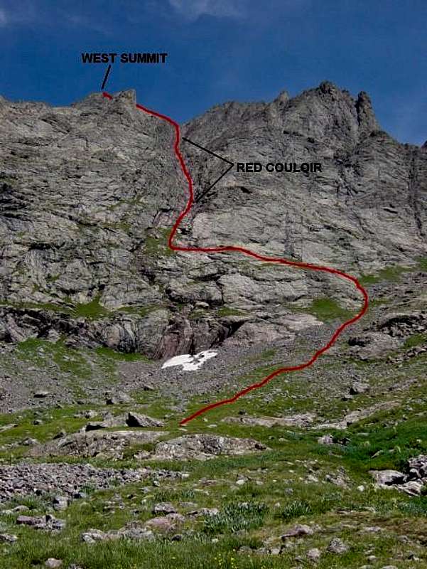
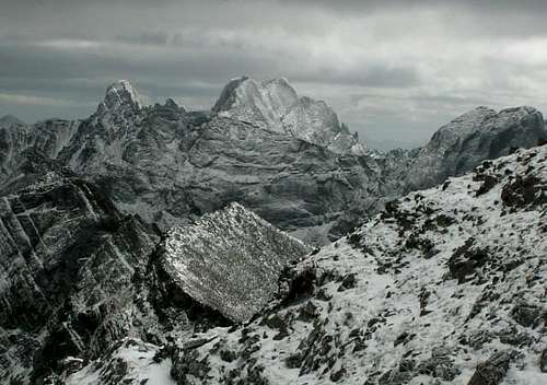
Standard Route up the red couloir
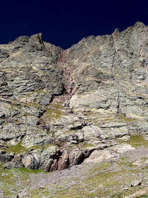
Looking up the red couloir
Angle over to your right, following the fading trail up through tundra. Cairns will likely be present, leading onto a shelf upon which you can angle left to gain access to the Red Couloir. The red and white streaked rock is very hard and has weathered erosion forces well. The result is a series of steps, ladders, ledges and chutes, mostly on the right side of the couloir. Many fun scrambling choices will present themselves. Depending on your group’s ability, plan on at least two hours of sustained Class 3 climbing up the south face.
At the top of the couloir is a spot known as the Red Saddle, a tiny perch between the Peak’s two distinct summits. From here, slightly harder Class 3 climbing leads to the east summit. A brief, moderately exposed traverse that is well traveled leads to the higher western summit, which involves a scramble over a rib, a drop of about five feet and a final scramble to the top. Both summits feature lots of air! Return the same route. Round trip from lower South Colony Lake is 4.6 miles with 3850 ft in elevation gain.
NOTE: Upon arrival at lower South Colony lake, the trail forks, and a brand new wooden sign will greet you. The sign says, "Crestone Needle Standard Route," with an arrow pointing to the left. Take the left fork to begin the approach to Broken Hand Pass, and the Standard South Face (Red Couloir) route of Crestone Peak. Take the right fork if doing the Northwest Couloir route on Crestone Peak.
NORTHWEST COULOIR
The most direct route, and long considered the standard route, is the northwest couloir, which meets the Standard Route at the Red Saddle between the Peak’s summits. A good description of the route can be referenced in Gerry Roach’s “Colorado Fourteeners: From Hikes to Climbs.” The route is also accessed from the Spanish Creek approach. This is a Class 4 route, involving considerable exposure and changing conditions. It is not recommended for novice climbers.
A round trip combination of the Standard and Northwest Couloir is possible. Climbing the Northwest Couloir and descending the Standard route is feasible. Ascending the Standard and descending the Northwest Couloir requires considerable route finding and mountaineering skills, and familiarity with the Northwest Couloir route is highly recommended.
COMBINATION ROUTES
Considered one of four classic traverses in Colorado, these routes involve climbing both the Needle and the Peak. There is a higher and lower traverse. Both require experience, and serious exposure is sustained for most of your time on the mountains and the ridge between them. The lower route is rated Class 4 and is usually done without rope and rack. The higher route is a technical traverse requiring equipment and mountaineering skills. Both routes include a dowbclimb/rappel or direct ascent of the Needle’s north face, and exposure is reportedly awesome. Do your research, and know your ability, gear and partners very well before attempting. The Crestone Peak to Needle Traverse is a fantastic way to link up these two great mountains. SP member Matt Mahoney has submitted an excellent route description of the lower traverse to the Crestone Needle page. Be sure to visit the Crestone Needle page for more valuable information on this classic traverse and options.
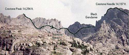 Crestone Peak-Needle traverse
TECHNICAL CLIMBING
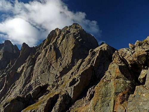
Established technical climbing routes for Crestone Peak include the North Buttress (4th Class), North Pillar (5.8R), India (5.8), and House Buttress (5.8).
 North Buttress (Class 4) North Buttress (Class 4) |
 |
Camping/Red Tape
There are designated campsites along South Colony road which are first-come, first-served. In South Colony basin, the Forest Service is in the process of constructing designated campsites, so try to use one of those. Otherwise, no camping is allowed withing 300 feet of either Lower or Upper South Colony Lake. For the western approaches, or for the Standard route from Broken Hand Pass, good camping is available at Cottonwood Lake. Good camping can be found near tree line on the Spanish Creek approach. No permits required. Crestone Peak is located in the Sangre De Cristo Wilderness. Please observe wilderness protocols during your visit.
The South Colony road is bordered by private property, as are the west approaches for the Spanish/Cottonwood Creek access. Please observe land owner's rights, obtain permission for entry and remain on designated trails.
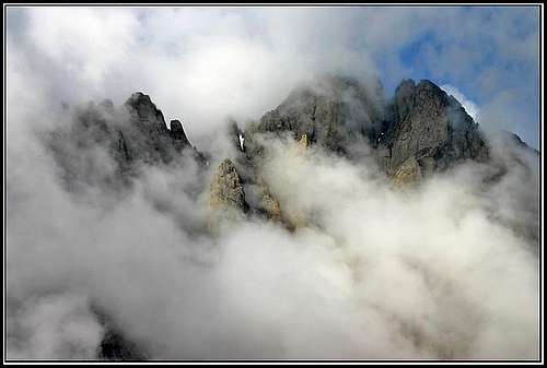 A rare Cascades-esque view of Crestone Peak peeking through clouds
When To Climb
The best time to climb Crestone Peak in optimal dry conditions is July to August. September can be a good time to climb, but early snows can increase difficulty of these routes dramatically. Climbing October through June will be in winter conditions. Steep snow and ice will be encountered. The Northwest Couloir may have snow and ice year round. In summer, plan to be off the summit by noon to avoid the afternoon thunderstorms that are all so common in the Rockies.
 The NE Coiloir in Spring The NE Coiloir in Spring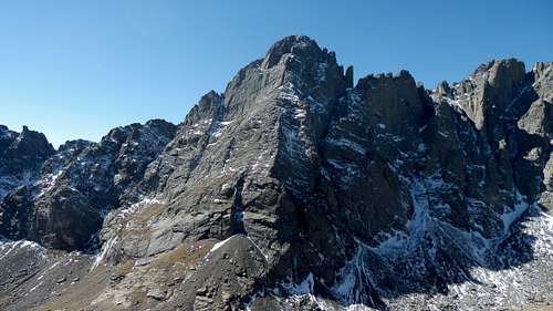 Crestone Peak in Fall Crestone Peak in Fall |
 Crestone Peak in summer Crestone Peak in summer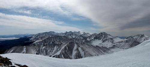 The Crestones in Winter The Crestones in Winter |
Map

Topo map of the Crestone Peaks
Mountain Conditions
San Isabel National Forest
2840 Kachina Drive
Pueblo, Colorado 81008
(719) 553-1400
Crestone Peak is in a remote location in a large wilderness area. Any acquired information should NOT be considered specific for the mountain due to constantly changing conditions.
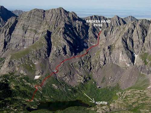 Route up to Broken Hand Pass (mostly a trail)
Climbing History
According to the various revised editions of Guide to the Colorado Mountain by Robert Ormes, more commonly known as the Colorado Mountain Club (CMC) guide, The Crestones were the last fourteeners to be climbed. Prominent Colorado mountaineering figure Albert Ellingwood (of La Plata Peak’s Ellingwood Ridge fame) successfully climbed both mountains in 1916, accompanied by Eleanor Davis Ehrman. A rare breed to be sure, this notable female mountaineer was still relating the account of their historic climb in 1990 at the age of 104. In 1925, Ellingwood and partners returned to climb the Crestone Needle via the classic Ellingwood Arete, now regarded a classic technical route in North America.
Due to the remoteness of these mountains, historic climbs were sporadic when compared to other Colorado mountains, but a number of important technical routes were established in following years that are still in use today. They include the Merhar, Whitney, Arnold-Michel (Needle), India, and House Buttress (Peak) routes. More recent routes on the Peak include the North Buttress (Class 4) and the North Pillar (Class 5.8). Route illustration photo by Harry Standley scanned from the Fourth Revised Edition of Guide to the Colorado Mountains by Robert Ormes.