
-
 80128 Hits
-
 91.75% Score
-
 37 Votes
|
|
Mountain/Rock |
|---|---|
|
|
37.98690°N / 106.9308°W |
|
|
14019 ft / 4273 m |
|
|
Overview
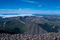
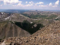
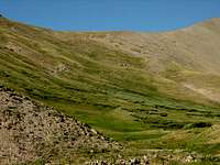
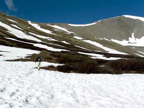
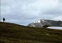
San Luis Peak is Colorado's 51st highest peak and is most noted for being the most difficult of the 14ers to get to. Situated about 2 hours from the nearest paved road you have to want to climb this one to make the effort to get there. The peak is a relatively simple Class 1 climb, beginning with a long nearly flat ascent past numerous Beaver Creeks. From here the trail begins to climb a bit steeper, but as far as 14ers go this one is relatively easy and straightforward, on trails the whole way.
The easiest route and most popular route is Class 1 from the Stewart Creek Trailhead. It is 12 mile roundtrip with an elevation gain of 3600 feet.
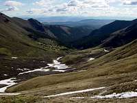
From the trailhead to the treeline is an easy 4 mile hike all on trails. Around treeline the trail turns to thesouthwest to a saddle between San Luis and Organ Mountain. From the saddle climb west on a good trail to the summit ridge and follow the ridge another 1/2 mile to the summit.
 |
 |
 |
Getting There
The hardest part about this mountain is getting to the trailhead. I searched the internet and several guide books and found this approach to be quite good. I found the trailhead in the dark of night without difficulty and did not need any additional maps for all the small dirt trails.
From Gunnison go east 7-8 miles on Highway 50 to CO 114 and turn right (south). Follow CO 114 about 20 miles and turn right on dirt road NN14. Start measuring distance from here. Take NN14 about 7 miles, just past both of the Dome Lakes.
Turn right onto road 15GG (also known as FS794). There are signs that will direct you to the Stewart Creek trailhead from here. Drive about 21 more miles on this road and you will see the trailhead on the right at just about mile 28. The roads were fine and I think could be made easily with most passenger cars. You can also get to Stewart Creek Trailhead from Lake City. Head south on Hwy 149 from Lake City 8 miles to Slumgullion Pass.
Turn left (north) onto 788 and measure from this point. Go approximately 21.7 miles to 790 and turn right. There is a sign directing you to Stewart Creek Trailhead here.
At approximately mile 31.5 turn right again onto 794.2B, again there is a sign directing you. You will cross Pauline and Perfecto Creeks. At about mile 35.3 turn right again onto 394. Cross Chavez and Nutras Creeks then proceed to the Stewart Creek Trailhead at about mile 39.9. Signs are good and the dirt roads are in good condition.
There are lots of small dirt roads in the area, and a couple other ways to get there have been submitted by other summitposters: From Creede, drive south through the canyon staying left at the fork. Continue to the to the Equity Mine that is about 7.5 miles north of creed. If you are driving a 4x4 continue south to where the road turns steeply west. Continue a few yards north and park. The trail (old 4x4 road) continues across the creek and up the hill to the northeast, or you can continue up the creek to the saddle where the Colorado Trail is.
Follow the Colorado trail to where the south ridge of San Luis Peak intersects the trail. If you followed the 4x4 road, the Colorado trail is just north of the ridge. A little bush whacking is required to find the trail but it is easy to find. If you follow the trail down into the glen there are many good camping places.
An alternate route with the trailhead only 7.6 miles from the nearest paved road (town of Creede) is the West Willow Creek approach. Follow an old 4 wheel drive road until you reach the Colorado Trail. This also gives the bonus of crossing the Continental Divide. This approach consists of crossing 3 saddles enroute to climbing the southern ridge. It is an easy class 1 hike although somewhat long (10.6 miles from the 4WD parking area).
big g adds the following information on Aug 17,2003 about West Willow Creek: I used Roach's Colorado Fourteeners book to locate this trailhead. The directions are good but here are a couple points I would like to make.
First the Willow Creek bridge is unlabeled but it is the small bridge in the center of town where 149 makes the "U".
Second 2 of the the 3 dirt roads mentioned on the "gentler" approach are now paved for a short distance.
The 2WD portion of the route is in excellent shape for any vehicle. The 4WD section is also good but high clearance is required. I never put my Blazer into 4WD.
MAPS:USGS Quads San Luis Peak, Stewart Peak,Elk Park, Gunnison National Forest
 |
 |
 |
 |
Mountain Conditions
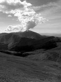
Conditions on this mountain, like all Colorado 14ers, are subject to change rapidly - especially during the prime climbing summer season. The mountains are their own weather system, and weather forecasts from nearby towns often have little to do with actual mountain conditions. You can generally count on clear to partly cloudy in the morning, and heavy clouds and thunderstorms in the afternoon during the summer climbing season.
There is no substitute for getting an early start, and getting as much of the mountain "behind you" as early in the day as possible. Keep a good eye on the sky as weather conditions can deteriorate rapidly. The greatest weather danger is from lightning strikes, and climbers are killed almost every summer in Colorado by lightning strikes. July seems to be the most deadly month for lightning. Two climbers were killed by lightning in Colorado within a couple days of each other in the summer of 2003.
I think the following important information from Gerry Roach's book "Colorado's Fourteeners From Hikes to Climbs" bears repeating. Added here with permission from Gerry Roach: Colorado is famous for apocalyptic lightning storms that threaten not just your life, but your soul as well. This section will have special meaning if you have ever been trapped by a storm that endures for more than an hour and leaves no gap between one peal of thunder and the next. The term simultaneous flash-boom has a very personal meaning for many Colorado Climbers.
Dangers
1. Lightning is dangerous!
2. Lightning is the greatest external hazard to summer mountaineering in Colorado.
3. Lightning kills people every year in Colorado's mountains.
4. Direct hits are usually fatal.
Precautions
1. Start early! Be off summits by noon and back in the valley by early afternoon.
2. Observe thunderhead buildup carefully, noting speed and direction; towering thunderheads with black bottoms are bad.
3. When lightning begins nearby, count the seconds between flash and thunder, then divide by 5 to calculate the distance to the flash in miles. Repeat to determine if lightning is approaching.
4. Try to determine if the lightning activity is cloud-to-cloud or ground strikes.
5. Get off summits and ridges.
Protection
1. You cannot outrun a storm; physics wins.
2. When caught, seek a safe zone in the 45-degree cone around an object 5 to 10 times your height.
3. Be aware of ground currents; the current from a ground strike disperses along the ground or cliff, especially in wet cracks.
4. Wet ropes are good conductors.
5. Snow is not a good conductor.
6. Separate yourself from metal objects.
7. Avoid sheltering in spark gaps under boulders and trees.
8. Disperse the group. Survivors can revive one who is hit.
9. Crouch on boot soles, ideally on dry, insulating material such as moss or grass. Dirt is better than rock. Avoid water.
The following link is also helpful: Lightning Safety and Crouch.
Also see this report by nchenkin It will make you really think about lightning safety: Struck By Lightning!
 |
 |
Camping
Camping is readily available at the trailhead at no cost. The climb is a relatively easy one from the trailhead, so there really isnt a lot of need to hike into the backcountry to camp.
 |
 |
 |
 |
 |
When To Climb
July and August are high seasons and the best time to climb. I did it on a Sunday in July and believe there were still only 11 people to summit that day. Just remember the summer Colorado weather is quite unpredictable, and storms are quite common especially in the afternoon. Try to get an early start and be off the summit by noon is a good rule of thumb.
 |
 |
 |
 |
People Pics and Miscellaneous Info
Add your People Pics and any other miscellaneous information here.
 |
 |
 |
External Links
COLORADO 14ERS INITIATIVE LEARN MORE ABOUT COLORADO 14ERS AND VOLUNTEER OPPORTUNITIES
Leave No Trace
Check out the web site of LNT and learn some important minimum impact hiking tips.
Colorado Mountain Club
CMC’s web site will tell you all you need to know about Colorado’s largest and oldest hiking club.
- San Luis via Stewart Creek
- Tour de San Luis (08/09/2005)
- 14ers.com - The Home of Colorado's Highest Peaks
Fourteener Photos, Route Descriptions, Forum, and more... - Solitude on San Luis Peak 13-sep-2005
djilk - Aug 28, 2006 2:35 pm - Hasn't voted
Driving directionsTwo things: On the directions from Lake City, the turn at mile 35.3 it should be road 794, not 394. Second, we followed the directions from US 50 (Gunnison side) on the main page, and these were much simpler than those on the east slopes Route page. However, it was wet and people should be warned that in wet/muddy conditions the road conditions degrade significantly - there was a two-mile portion where we had to use 4WD-low to get through the mud. The roads to Lake City (reversing the directions) handled the wet conditions better.