
|
|
Mountain/Rock |
|---|---|
|
|
0.26061°N / 78.18061°W |
|
|
Hiking, Scrambling |
|
|
Spring, Summer, Fall, Winter |
|
|
15190 ft / 4630 m |
|
|
Overview
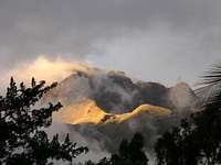 The summit of Imbabura
General overview Imbabura is a long-extinct volcano located 60km northeast of Quito near the town of Otavalo. Otavalo is well known for it's colorful local market which is believed to the be one of the oldest in South America. Visiting this area without attending the market to barter with local merchants would be a crime. Imbabura is a stand alone peak that resides over the breathtaking Lago San Pablo outside of Otavalo. This once glaciated peak use to be an important ice source for local villages. The locals would climb high onto the mountain to get ice from the glacier and carry it back to the village. The gentle slopes make this mountain the perfect acclimatisation climb for those who plan to tackle the higher peaks in Ecuador. Even if you don't plan on other climbs, Imbabura makes a great trek in it's own right. The climb will take you through tall grasses into rocky outcroppings, followed by suprisingly lush vegetation high on the mountain. Imbabura is sometimes included in Ecuador's Big Ten which is not accurate as its summit elevation is almost 400m lower than number ten (Tungurahua) on that list.
Climbing overview Its normal route is rated PD (grade 4 rock). The climb is typically done in one day from either Quito or one of the incredible local haciendas. There are two main summits on Imbabura. The second one, 100m higher than the first, can be reached via the knife edge crater rim from the north summit at the end of the normal route. Many hikers claim victory at the first, lower summit as the walk along the rim can trigger a feeling of danger. It is quite airy and exposed and the rock is rotten. Be careful. Many climbers arrive directly from Quito, which is at an altitude of 2800m. Imbabura is not a high Andean peak, but it's still higher than all US peaks in the lower 48 and almost as high as Mont Blanc. Don't underestimate Imbabura's elevation. I saw many hikers with headache and some were feeling really bad and had to go back down without reaching the summit. Better acclimatize a bit before and the hike on Imbabura's will be a great experience. I met some climbers warming up with Imbabura, acclimatizing for the higher, nearby located Cayambe. The owner of the local hostel told me this is quite common.
Getting There
 The strange "bus-train"
There are two starting points for the standard route depending on your choice of transportation. For those using public transport the starting point is La Esperanza, a small village located at 2600m outside of the city of Ibarra. If you choose private transport you'll start 4km up the road from La Esperanza in the small village of Chiriuasi at 2950m.
PUBLIC TRANSPORT: From Quito, there are regular buses leaving Terminal Terrestre for Otavalo where you can take a taxi or buss to Ibarra. Once in Ibarra you can take a bus to the small village of La Esperanza. Most climbers make it to La Esperanza one day and climb the next. La Casa Aïda in La Esperanza is the only suitable hostel in the city but it is a little paradise! It provides good food and can organize transportation to trailhead cutting the extra 4km off the climb. The following was added by SP member Irene+: There is no need to stop in Otavalo. There are plenty of bus companies that go directly from Terminal Terrestre to Ibarra; make sure not to use Expreso Turismo (a yellow&white bus with red curtains), it is cheaper (2$ instead of 2,50$) and so it gets really overcrowded, with 3-4 people seating on 2 seats. Transportes Andinas (blue&white buses) offers the ride for 2,50$ and is less crowded. Once in Ibarra you have to traverse cross town (5-10min walk) to get to another bus station, from where you pick the bus for La Esperanza. Trucks from La Esperanza JGHarrisson says: It is possible to get a truck to the trailhead from La Esperanza without staying at Casa Aida. The best bet is to go to the only bridge in town, often there are a number of trucks in the parking lot by the bridge. The going rate to hire a truck to the trailhead as of Feb 09 is $4.
 Take-off!
PRIVATE TRANSPORT: Private autos and drivers can most easily be hired in Quito using one of the local agencies. This will get you from Quito to the trailhead in Chirihuasi at 2950m and maybe a little further to 3200m when conditions are dry. Private transport may also be arranged at Casa Aida in La Esperanza. Most agencies located around "New" Quito near Veintimilla and Amazonas streets offer a wide variety of services ranging from fully guided tours to transport only. Shop around for the best ones and you shouldn't pay much more than $100US for a private auto and driver for up to 4 climbers.
Red Tape
No fees or permits required.
When To Climb
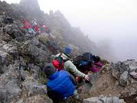
 Typical scrambling on Imbabura
Imbabura can be climbed year around but is best climbed during the dry seasons which run from June through August and December through February. Be aware that rain and mist are the norm for the area. Mornings tend to be the clearest.
Camping & lodging
Camping is permitted with no charges but it is not necessary unless you want to spend the night high on the mountain. There are no campgrounds in the village at the trailhead. Cendres adds: Casa Aida is a great place to stay in La Esperanza. It is run by Aida Buitrón. The phone number is (593-6) 2660221. Unfortunately the phone number listed in many guidebooks is incorrect.
Mountain Conditions
 On the trek
Imbabura is usually snow free but can often have a covering of snow high on the mountain after a storm. I was told the higher reaches of the mountain is many times in the clouds. It was the case when I attempted the peak and visibility was many times down to 15-20 meters. The clouds bring high humidity and makes the climb both cold and wet. Bring some clothes for chilly and wet surroundings even if it's really hot when starting the climb. Most of the climb is a trail until high on the mountain where there are several sections of scrambling, on often loose rock. The clouds and the low visibility made me loose the trail high on the peak and I ended up on rocky sections with rock climbing. Be careful with the route finding and you'll have nothing but easy scrambling to deal with. The main trail is passing a potable water station at around 3700m. Its easy to fetch water from the top of one of the tanks.
A word of caution
I met hikers and climbers who had turned back because of unstable rock, big exposure and "scary" scree areas. For many people Imbabura is a pleasant hike, but missing the main trail and/or expecting a very easy walk can turn the trip into a quite scary experience. danslb posted a comment I think should be on the main page. "I had done Fuya Fuya at 4260mt, the hike around cuycocha and the hike around Quilotoa at 3900, all with no real problems. I set out at the trailhead of Imbabura after getting the truck from the bridge at Esperanza. I started at 10:30am and reached the trailhead coming back down at 7pm. I had to walk the last half hour or so down to the trail head in the dark using a head lamp. I should have taken the phone number of the driver who dropped me off. I walked for over an hour on the cobble stone road trying to make it back to Esperanz, in the dark. I suggest climbers set out earlier than I did especially if planning to do the second peak which I did. There was more rock climbing than I had expected or have ever done. The knife edge is very dangerous in my opinion and should not be done alone which I did. The descent from the mountain was muddy and brutal on the knees and slowed me down a lot. At 8:30 pm I started stopping people and asking for a place to stay. I was pointed to a house located on the side of the road leading up to the trailhead. It is located above Esperanza in the village of Chirifuasi. The hosts Clever Tuqueres and Aurora have three daughters and would like to open a hostel. There was dinner and breakfast and a warmish shower. There was also internet as they run a small internet cafe in the house. I offered 15$ and they accepted. The family was very nice and welcoming. Clever's phone: 0969433993"
Updates on hike and logistics
Hiked Imbabura on 23.09.2018. A couple of comments on the hike and logistics: - most of the freshwater tanks are fenced and locked, and it looks like they are building a new fence around the part that is currently still accessible, so maybe don't rely too much on being able to refill your bottles there - we took a taxi from the centre of Ibarra to Casa Aida (5 USD), where we stopped for an amazing breakfast (pancakes and fresh croissants with mora jam); we didn't stay at Casa Aida, but it looks like a great place (18 USD per person per night including breakfast and dinner, breakfast was 4 USD) - from the bridge just up the road from Casa Aida we took one of the caminetas (pickups) to the trail head (6 USD for both of us); this shaves off a significant amount of distance and elevation gain - from the trailhead at the end of the cobbled road where we were dropped off it was 5.8 km to the highest point and 1300 m of elevation gain according to my GPS watch; the trail/scrambling along the ridge from the north summit to the south summit adds more than a third of the total distance - at a fairly leisurely pace and with lots of photo stops (it is a stunning place!), it took us 4h 20 minutes to reach the south summit - we were very lucky with the weather, the peak was clear until about midday, and afterwards the clouds moved in and out; same on the following day, the peak was completely cloud free in the morning - we only started the hike at 8:00, but starting earlier has the advantage of less sun exposure (the sun only comes over the mountains opposite around 7:30) Information contributed by Konstantin 2018 09 24
Update May 2017 & April 2018
The following information was added by dobozban in the spring of 2017. We did this hike in May 2017 to the ante-cumbre, but didn't proceed to the true summit because it was completely clouded over. On the way down we got some better views of Ibarra and the valley with La Esperanza. We stayed in the area for several days and it seemed like views were actually better in the early afternoon than the morning. I include the following notes/updates: - The rate for hiring a truck from the bridge is $6 as of May, 2017 - From Ibarra take a bus from the Terminal de Buses "La Esperanza", which is next to Parque German Grijalva a few blocks east of the main bus terminal, although you can also catch one on the street in front of the terminal, Av Eugenio Espejo. It costs $0.30. Make sure you get one that goes to "Zuleta" because the road to the trailhead is several km past the village center of La Esperanza where many of the buses terminate. - Casa Aida charges $10 pp for a room w/shared bath (hot showers) or camp for $6 pp, $5 for dinner and $4 for breakfast. The meals were tasty, but maybe a bit overpriced, unless you're willing to pay a premium for something different from the standard Ecuadorian restaurant fare. - There is now a hostel of sorts about halfway up the road from La Esperanza to the trailhead with a sign advertising "camping, campfires, breakfasts", but we were in vehicles so have no contact info.
Route notes: - You will probably be dropped off at a Y just past the end of the cobblestones, take the left fork up the steep hill - Shortly past a switchback, the road will drop to the right off the ridge. Follow the trail to the left that continues along the ridge to the water tanks (approx. 15 min from the road). - It's easy to miss the trail at the tanks. Do not take the overgrown trail to the left that continues along the same level. Climb up the trail on the back right corner of the tanks, but don't continue on the very wide trail that is more of a road. Just above the tanks there is another trail that climbs straight up from the "road" through bushes and continues on the spine of the ridge. - After the tanks junction, wayfinding is more straightforward. You will pass a sign that talks about how awesome the paramo is and gives rules to follow. The trail will continue very steeply up the ridge and can be very slippery. There is a lot of vegetation to soak your pants with morning dew, so be prepared for wet legs to keep from getting cold further up. - This steep section will continue for longer than you think before you reach a spot where the main trail will flatten out a bit going to the right below the ridge, but don't worry, it'll get steep again! If there is good visibility above, you might want to follow one of the minor trails to stay on the ridge for great views of the awesome gorge on the left. There is a flat area large enough to camp up here, but you'll have to endure some lumpy tufts of grass. - After the flat-ish section, there is another steep climb up the grass on a couple variations of the trail that will all converge at 4,000m (according to sign) at a point where the ridge climbs very steeply with a rocky cliff on the left. The main trail will continue below this cliff on the left and you'll start seeing cool paramo plants. I think you can continue up the ridge on a minor trail and reconnect with the main trail when it regains the ridge, but that will add a fair bit of climbing. - The trail regains the ridge at "Bosque de Polylepis" at 4,260m (according to sign).
There is a small camping spot here that is somewhat protected by some small rocks, with some potential for flooding. There is another, slightly larger camp spot a bit further up, but it appears even more to be a waterway. - You will continue on an easily followed trail along the narrow ridge until you get to the scramble area. I thought the trail was fairly easy to follow, even in low visibility because it is fairly worn. There are also some yellow dots painted. From the original description I was expecting crumbling rocks, but found the trail to be fairly stable, although there were a couple spots where the rocks were a bit loose, which may be even more dangerous because you get used to solid holds and then, surprise! Updates & additions April 2018 (Skappa) Two weeks ago I did this climb and made it to the second peak. I would like to add that Dobozban's route description is correct and helped me a lot. Maps.me (and probably all open street maps apps) has the entire route to the second peak as well. This helped me a lot while going down. The "Hostel" dobazban saw is in fact a hostel. Its called Refugio Volcan Imabura (can be found on Maps.me) and is owned by Klever Tuquerres the guy who helped out danslb. The price for a night is still $15 and includes breakfast. Dinner was included as well, but I'm not sure as to wether that is standard. He currently has a room with 2 bunkbeds and is building another room on top of his kitchen. This room will house 6 more people. He was thinking about buying tents as well to be able to house bigger groups. The number of his cellphone has changed. It's +593 98256949 now. On a different note, there are also busses going up the cobblestone road. Klever told me they depart at 10:30am, 1:00pm, 2:00pm, 6:00pm and 6:50pm from Terminal de Buses "La Esperanza". I don't know how far up the road they go. If you're planning to stay at Klever's get out at Parada 7. This bus stop is right in front of his house.
Links
- Summitpost's own page of guide books & maps for South America
- A nice photo of Otavalo and Imbabura
Credit
This page was originally submitted by Miztflip. A lot of his info is still around.
Math.Grenier - Apr 4, 2017 10:02 pm - Hasn't voted
QuestionI want to know how many kilometers from de Hostal Casa Aida ?
Corax - Apr 18, 2017 12:19 pm - Hasn't voted
Re: QuestionGoogle Earth is telling me it's about 9km, but as far as I remember it was closer to 15km when all the twists and turns are included. I'm talking about a one way walk now.
Konstantin - Sep 24, 2018 2:49 pm - Hasn't voted
Updates on hike and logisticsHiked Imbabura on 23.09.2018. A couple of comments on the hike and logistics: - most of the freshwater tanks are fenced and locked, and it looks like they are building a new fence around the part that is currently still accessible, so maybe don't rely too much on being able to refill your bottles there - we took a taxi from the centre of Ibarra to Casa Aida (5 USD), where we stopped for an amazing breakfast (pancakes and fresh croissants with mora jam); we didn't stay at Casa Aida, but it looks like a great place (18 USD per person per night including breakfast and dinner, breakfast was 4 USD) - from the bridge just up the road from Casa Aida we took one of the caminetas (pickups) to the trail head (6 USD for both of us); this shaves off a significant amount of distance and elevation gain - from the trailhead at the end of the cobbled road where we were dropped off it was 5.8 km to the highest point and 1300 m of elevation gain according to my GPS watch; the trail/scrambling along the ridge from the north summit to the south summit adds more than a third of the total distance - at a fairly leisurely pace and with lots of photo stops (it is a stunning place!), it took us 4h 20 minutes to reach the south summit - we were very lucky with the weather, the peak was clear until about midday, and afterwards the clouds moved in and out; same on the following day, the peak was completely cloud free in the morning - we only started the hike at 8:00, but starting earlier has the advantage of less sun exposure (the sun only comes over the mountains opposite around 7:30)
Corax - Sep 26, 2018 12:18 am - Hasn't voted
Re: Updates on hike and logisticsThanks! All included on the main page now.