
|
|
Mountain/Rock |
|---|---|
|
|
37.96720°N / 119.3192°W |
|
|
Hiking, Mountaineering, Trad Climbing, Big Wall, Scrambling, Skiing |
|
|
Spring, Summer, Fall, Winter |
|
|
12590 ft / 3837 m |
|
|
Overview
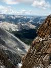
Mount Conness is the highest peak in Sierra Nevada north of Tioga Pass Road (Highway 120). It is a prominent peak on the eastern boundary of Yosemite National Park, whose vertical southwest wall (one of the best spots for big wall climbing in the Tuolumne Meadows area) is visible from many points on Tioga Pass Road (Hwy-120). On the Sierra Nevada crestline, Mount Conness is the first high ridge at the head of the vast and low Tuolumne basin, a position that bears the brunt of winter snow storms. Hence it has the second largest glacier in Yosemite after Mount Lyell, and the entire area retains much snow for most of the summer. Northeast of Mount Conness is the enchanting Twenty Lakes Basin fed by its glacier. Accessed by the high trailhead of Saddlebag Lake (10060 feet), the basin is popular for fishing, and allows short, easy approaches to the Conness crest peaks.
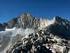
The summit of Mount Conness is class 2 from Young Lakes on the west side (easiest route), which requires a long approach from Tuolumne Meadows trailhead in Yosemite National Park. The east side approach is shorter but a bit more difficult. Mount Conness offers challenging technical rock routes on its north ridge and southwest wall. Nearby North Peak has two steep couloirs popular for ice-climbing. For those interested in less technical scrambles, Mount Conness crest area is paradise. The relatively gentle terrain, clean granite and lack of vegetation make for many thrilling off-trail routes. In winter and spring, the abundant snow cover on the gentle Mount Conness crest make for ideal skiing conditions; the area south to Tioga Pass is especially popular.
 |
 |
 |
 |
 |
Getting There
Eastside trailhead: Saddlebag Lake, elevation 10060 ft. Take California Highway 120 (Tioga Pass Road) to about 2 miles east of the east entrace of Yosemite National Park (Tioga Pass), turn to Saddlebag Lake Road on north side of highway, proceed to the end. There is a resort there at the lake. Saddlebag Lake Road is partly a dirt road but does not require high clearance vehicles. The shortest route from here to the summit of Conness is approx. 3.3 miles, elevation difference is 2600 feet.
Westside trailhead: Tuolumne Meadows., in Yosemite National Park about 8 miles west of Tioga Pass, the east entrance to the park. Take the trail to Young Lakes. The route from Young Lakes to the summit plateau is class 2.
 |
 |
 |
 |
 |
Red Tape
Requires camping permit (free of charge) if doing backcountry camping in Yosemite National Park or Hoover Wilderness (the area north of Saddlebag Lake). If you use the eastside trailhead, permits can be obtained at the National Forest ranger station in Lee Vining on Highway 120 west of junction with US-395. If you use the westside trailhead in Yosemite National Park, go to the "Wilderness Permits" office in Tuolumne Meadows. Campfires are generally prohibited in the area. To deter black bears, use a bear box to store food overnight.
When To Climb
Summer season from late May to October is easiest. Logistic difficulty in winter when Highway 120 is closed. Possible to reach area on cross-country skis in winter.
 |
 |
 |
 |
 |
Camping
Backcountry camping: free in Yosemite National Park or Inyo National Forest (except for Hall Natural Area). Camping is not allowed in Hall Natural Area, which encompasses an area roughly within 3 miles of the crest on the east side, including areas around Alpine Lake, Conness Lakes, and Conness Glacier. If backcountry camping in Yosemite National Park or Hoover Wilderness, permits are required (see Red Tape section).
Roadside camping is generally prohibited in the area except in fee campgrounds such as Saddlebag Lake and Sawmill campgrounds off Saddlebag Lake Road, or Tioga Lake, Ellery Lake, or Lee Vining Creek campgrounds along Highway 120 east of the park.
You can also stay in cabins in Yosemite National Park along Tioga Road, around Tuolumne Meadows. Commercial lodging can be found at the Tioga Pass resort just outside Yosemite National Park, and in the towns of Lee Vining (closest), June Lake, or Mammoth Lakes (furthest).
External Links
- Richard Steeleman's May 2002 ski tour
- June 2002 climb/ski via the Glacier Route
- White & Conness - Aug 1, 1993
- Ragged/Conness/White dayhike - June 10, 2004
- Mt Conness -- Photos of climb up the East Ridge via Alpine Lake, 8/17/2005
chris_r - Feb 9, 2004 3:05 pm - Hasn't voted
Untitled CommentThe fine and time honored S.W. face route (Harding) is beautiful. The route consists of 5.7 to 5.10- climbing on somewhat weathered granite, including a fairly areobic 10b offwidth. On a full moon night, Warren Harding himself can still be seen whacking ancient 1950s vintage bolts in on the offwidth section.