
-
 68157 Hits
-
 92.32% Score
-
 38 Votes
|
|
Mountain/Rock |
|---|---|
|
|
38.96060°N / 106.3606°W |
|
|
14205 ft / 4330 m |
|
|
Overview
As far as fourteeners go, Belford is a relatively easy peak. Starting from the Missouri Gulch TH the trail is Class 1 and then class 2 if you do the West Slopes approach. Many climbers will climb Mt Oxford after Mt Belford as it is only a dip down to a saddle and then back up the other side. The two mountains are only about a mile apart. However, be sure you check the weather well before making a commitment to go to Oxford. You will be on the connecting ridge for maybe a couple hours back and forth, and should weather come up there is little place to hide.
Missouri Mountain is also close by, but if you try to do all 3 in one day be prepared for a good workout as it is 14 1/2 miles with a gain of 7400 feet. The Belford/ Oxford combination is 11 miles and 5900 feet elevation gain, and Belford alone is 7 miles with a gain of 4560 feet.
Belford is a fun peak to climb, although the series of switchbacks on the Missouri Gulch route are tedious. Many people climb Belford, because it provides the most popular access to Mt. Oxford, and Missouri is also nearby.
 |
 |
 |
 |
 |
Getting There
From Buena Vista go 15 miles north on US 24 to Chaffee County 390. Or from Leadville head 20 miles south on US 24. Take 390 west for 7.7 miles and you will see the Missouri Gulch Trailhead on your left. This is the most popular trailhead. You can reach Belford, Oxford and Missouri from this trailhead. The trailhead has ample parking and toilet facilities.
The most popular, and easiest route up Belford is up the West Slopes from Missouri Gulch TH. It is class 2 and is considered one of the easier 14 ers.
 |
 |
 |
 |
 |
Route Information
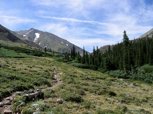
Starting from the large parking lot and trailhead, the route starts over a nice bridge crossing Clear Creek. It immediately starts through the forest with a nice series of switchbacks. Cross the multi log bridge back over the creek. The trail is in good condition and easy to follow. Shortly after passing the "cabin" mentioned in the camping section the trail rises above tree line into the broad Missouri Gulch and the rest of the trail comes into sight. After a bit, a sign marks the fork where the left trail leads to Belford and the right trail leads towards Missouri.
The trail rises to a steep slope full of rock steps at the steepest parts of the trail. Eventually, after switchbacking up this slope, the trail leads you right to the small summit.
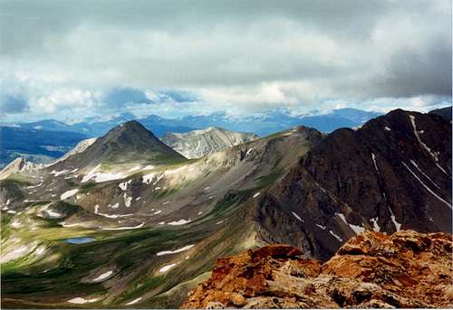
If you are going to climb Oxford too, then descend southeast after the summit to the saddle then up the west ridge to the Oxford summit. It takes about 1 to 1 1/2 hours to get to Oxford and about the same getting back. This is a fair amount of time along a high ridge so try to get as early a start as possible so as to reduce your chances of being on the ridge should storms hit.
I would recommend actually starting on this route about an hour before sunrise with flashlights or headlamps. My climbing partner and I did this and we, along with one other climber who left even earlier, were the only ones to make both Belford and Oxford summits that day. When rain and wind started at an early 10:30 AM the three of us had already summited Oxford and were making fast time to get back over Belford and work lower. Climbers who had not yet summited Belford or headed for Oxford saw the sudden storms coming in and wisely turned around. The climb back up Belford from the saddle is a bit steep... save some energy for it. Once back over the Belford summit, the return route is the same as the approach.
 |
 |
 |
 |
 |
Mountain Conditions
Most people will climb Mt Belford from the Missouri Gulch trailhead. It is a relatively easy trail and conditions are good. Without much extra effort you can descend the saddle to the east and then back up the other side to also bag Mt Oxford the same day.
Conditions on this mountain, like all Colorado 14ers, are subject to change rapidly- especially during the prime climbing summer season. The mountains are their own weather system, and weather forecasts from nearby towns often have little to do with actual mountain conditions. You can generally count on clear to partly cloudy in the morning, and heavy clouds and thunderstorms in the afternoon during the summer.
There is no substitute for getting an early start, and getting as much of the mountain "behind you" as early in the day as possible. Keep a good eye on the sky as weather conditions can deteriorate rapidly. The greatest weather danger is from lightning strikes, and climbers are killed almost every summer in Colorado by lightning strikes. July seems to be the most deadly month for lightning.
Two climbers were killed by lightning in Colorado within a couple days of each other in the summer of 2003. I think the following important information from Gerry Roach's book "Colorado's Fourteeners From Hikes to Climbs" bears repeating. Added here with permission from Gerry Roach:
Colorado is famous for apocalyptic lightning storms that threaten not just your life, but your soul as well. This section will have special meaning if you have ever been trapped by a storm that endures for more than an hour and leaves no gap between one peal of thunder and the next. The term simultaneous flash-boom has a very personal meaning for many Colorado Climbers
Dangers
1. Lightning is dangerous!
2. Lightning is the greatest external hazard to summer mountaineering in Colorado.
3. Lightning kills people every year in Colorado's mountains.
4. Direct hits are usually fatal.
Precautions
1. Start early! Be off summits by noon and back in the valley by early afternoon.
2. Observe thunderhead buildup carefully, noting speed and direction; towering thunderheads with black bottoms are bad.
3. When lightning begins nearby, count the seconds between flash and thunder, then divide by 5 to calculate the distance to the flash in miles. Repeat to determine if lightning is approaching.
4. Try to determine if the lightning activity is cloud-to-cloud or ground strikes.
5. Get off summits and ridges.
Protection
1. You cannot outrun a storm; physics wins.
2. When caught, seek a safe zone in the 45-degree cone around an object 5 to 10 times your height.
3. Be aware of ground currents; the current from a ground strike disperses along the ground or cliff, especially in wet cracks.
4. Wet ropes are good conductors.
5. Snow is not a good conductor.
6. Separate yourself from metal objects.
7. Avoid sheltering in spark gaps under boulders and trees.
8. Disperse the group. Survivors can revive one who is hit.
9. Crouch on boot soles, ideally on dry, insulating material such as moss or grass. Dirt is better than rock. Avoid water.
The following link is also helpful: Lightning Safety and Crouch
Also see this personal account of a lightning strike by nchenkin- It will make you really think about lightning safety Struck By Lightning!
Camping
There is no camping allowed at the trailhead. Free camping is available along the left side of County 390 from highway 24 to the trailhead. There is no formal campground- just available primitive campsites. Many have fire rings and are near a creek.
There is also remains of an old log cabin about a mile or so up the route- just before you get to treeline. The "cabin" is full of scrap metal and has no roof- so you can't sleep in it, but surrounding it is plenty of area for a backcountry campsite. If you want to shorten the climb, or you plan to do Missouri from the same trailhead, and want to avoid the switchbacks at the lower end of the trail for a second time, you might want to consider carrying your camping gear to this site.
 |
 |
 |
 |
 |
When To Climb
The main season is June-September, with July and August being the busiest times of year. Try to climb during the week if possible for a more peaceful climb. As usual, summer thunderstorms should be expected in Colorado, so be prepared and try to get of the mountain by noon or 1PM. Be especially careful if you try to climb Belford, Oxford and Missouri all in the same day, for you stand a good chance of catching the afternoon storms.
Maps and Contact
MAPS San Isabel National Forest
USGS 7.5 minute quadrangles Mt. Harvard and Winfield
Trails Illustrated #129 Buena Vista/Collegiate Peaks
Leadville Ranger District
2015 North Poplar - Leadville, CO - 80461
Phone (719) 486-0749
Fax (719) 486-0928
People Pics and Miscellaneous
Add your People Pics and any other miscellaneous information here.
 |
 |
 |
 |
 |
External Links
COLORADO 14ERS INITIATIVE LEARN MORE ABOUT COLORADO 14ERS AND VOLUNTEER OPPORTUNITIES
Leave No Trace
Check out the web site of LNT and learn some important minimum impact hiking tips.
Colorado Mountain Club
CMC’s web site will tell you all you need to know about Colorado’s largest and oldest hiking club.
- 14 Fourteeners in 60 Hours
- Belford & Oxford
- Mt. Belford & Mt. Oxford (05/20/2005)
- Mt Belford - Aug 21 2004
- 14ers.com - The Home of Colorado's Highest Peaks
Fourteener Photos, Route Descriptions, Forum, and more...