
-
 80089 Hits
-
 91.88% Score
-
 37 Votes
|
|
Mountain/Rock |
|---|---|
|
|
38.61890°N / 106.2389°W |
|
|
14236 ft / 4339 m |
|
|
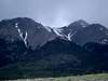
Overview
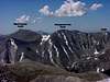
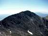
Mt. Shavano and Tabeguache Peak are the southernmost fourteeners of the Sawatch range and are usually climbed together . Shavano is also the easternmost 14 er in the Sawatch range. It is most noted for the Angel of Shavano on its east face. In spring and early summer the snow filled gullies resemble and angel with upstreched wings. All the routes are class 2 from any of the trailheads.
 |
 |
 |
 |
 |
Getting There and Route Information
There are 2 main trailheads, Angel of Shavano and Blank Gulch. Jennings Creek used to be a popular trailhead, but the route has been closed due to severe erosion.
To reach the Angel of Shavano trailhead, from Poncha Springs go west on US50 from the junction of US50 andUS285 for 6.1 miles. Turn north onto County 240 for 3.8 miles to the trailhead. The road is paved most of the way and is accessible by passenger car.
To reach Blank Gulch trailhead go south 20 miles on US 285 from the 285 US24 junction just west Johnson's Village near Buena Vista to Chaffee 140. The 285 Chaffee 140 junction is also 1 mile north of the 285 US 50 junction in Poncha Springs. Turn west on Chaffee 140 (paved) and measure from this point. Turn right on Chaffee 250 at mile 1.7, stay left at 5.7 miles on Chaffee 252, cross Placer Creek at 6.5 miles, continue straight and reach the trailhead after 9 miles.
Dafreshman also adds: For a more solitary and pretty approach to the Shavano/Tabeguache group, the Brown's Creek drainage is perfect. There is an easy way and a hard way to get to these peaks from Brown's Creek (drainage to the north of the peaks). The hard way is this: follow the directions in Roach's guidebook to the Brown's Creek trailhead. The approach to the peaks from here would normally involve an overnight backpacking outing. The easy way involves a 4WD vehicle: Go to the Baldwin Gulch trailhead (see Mt. Antero) and continue up the 4WD drive road that is the Baldwin Gulch approach on Antero. This rough road continues all the way up to a 13,800 foot saddle on Antero's southwest ridge, and then decends into the upper part of Browns Creek. There are several good camp spots in this valley, and the hiking is, in my opinion, much better from this side.
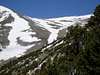
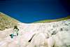
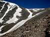
Perhaps the best route for climbing this peak is Angel of Shavano route from Blank Gulch trailhead. From the trailhead the climb is 7.9 miles with a 4430' elevation gain. It is rated as class 2 classic. From the trailhead hike north for 1/4 mile to the start of the trail. Stay on the trail to 11,000 just before the switchbacks. Bushwhack west up the drainage to the base of the Angel with outstretched arms. An ice axe is recommended when climbing this snow route. Even thought the slope is gentle it is possible to have a serious fall. At the top of the "body" you need to continue to climb up an "arm." The northern arm is generall y the choice as it leads directly toward the summit. Once out of the "arm" it is a talus scramble to the summit.
An alternate route is the East slopes route from the same trailhead. This route avoids the snow in the angel and is Class
1 all the way to the saddle between Esprit Point and Mt Shavano.
From the trailhead go north on the Colorado Trail 1/4 mile to the start of the Mt Shavano Trail. Climb the trail past tree line to the north of the Angel of Shavano basin. The trail leads to a saddle at 13,330 feet and from there it is a .6 mile scramble to the summit.
Maps: USGS Quads Maysville, Garfield, St Elmo, Mt Antero
 |
 |
 |
 |
 |
Mountain Conditions
Severe erosion has closed the Jennings Creek route. The Forest Service asks hikers to use Blank Gulch or Angel of Shavano trailhead. Conditions on this mountain, like all Colorado 14ers, are subject to change rapidly- especially during the prime climbing summer season. The mountains are their own weather system, and weather forecasts from nearby towns often have little to do with actual mountain conditions. You can generally count on clear to partly cloudy in the morning, and heavy clouds and thunderstorms in the afternoon during the summer.
There is no substitute for getting an early start, and getting as much of the mountain "behind you" as early in the day as possible. Keep a good eye on the sky as weather conditions can deteriorate rapidly. The greatest weather danger is from lightning strikes, and climbers are killed almost every summer in Colorado by lightning strikes. July seems to be the most deadly month for lightning.
Two climbers were killed by lightning in Colorado within a couple days of each other in the summer of 2003. I think the following important information from Gerry Roach's book "Colorado's Fourteeners From Hikes to Climbs" bears repeating. Added here with permission from Gerry Roach:
Colorado is famous for apocalyptic lightning storms that threaten not just your life, but your soul as well. This section will have special meaning if you have ever been trapped by a storm that endures for more than an hour and leaves no gap between one peal of thunder and the next. The term simultaneous flash-boom has a very personal meaning for many Colorado Climbers
Dangers
1. Lightning is dangerous!
2. Lightning is the greatest external hazard to summer mountaineering in Colorado.
3. Lightning kills people every year in Colorado's mountains.
4. Direct hits are usually fatal.
Precautions
1. Start early! Be off summits by noon and back in the valley by early afternoon.
2. Observe thunderhead buildup carefully, noting speed and direction; towering thunderheads with black bottoms are bad.
3. When lightning begins nearby, count the seconds between flash and thunder, then divide by 5 to calculate the distance to the flash in miles. Repeat to determine if lightning is approaching.
4. Try to determine if the lightning activity is cloud-to-cloud or ground strikes.
5. Get off summits and ridges.
Protection
1. You cannot outrun a storm; physics wins.
2. When caught, seek a safe zone in the 45-degree cone around an object 5 to 10 times your height.
3. Be aware of ground currents; the current from a ground strike disperses along the ground or cliff, especially in wet cracks.
4. Wet ropes are good conductors.
5. Snow is not a good conductor.
6. Separate yourself from metal objects.
7. Avoid sheltering in spark gaps under boulders and trees.
8. Disperse the group. Survivors can revive one who is hit.
9. Crouch on boot soles, ideally on dry, insulating material such as moss or grass. Dirt is better than rock. Avoid water.
The following link is also helpful: Lightning Safety and Crouch
Also see this personal account of a lightning strike by nchenkin- It will make you really think about lightning safety Struck By Lightning!
 |
 |
 |
 |
 |
Camping
The best place for camping is near Placer Creek on the drive in to the Blank Gulch TH. It is at 6.5 miles from the 285/ Chaffee 140 junction.
Camping is not really advised near the trailhead. There are "No Camping" signs posted around the trailhead, but they may be difficult to find. The Blank Gulch trailhead is really at a cow pasture, and if you camp in the vicinity you can expect cows to either moo you to sleep or stumble around your tent. Far better to sleep along the more enjoyable Placer Creek.
At the main TH parking lot there is also a sign that says "Overflow Parking and Dispersed Camping" I didn't have the chance to check this out but it was just a dirt road off of the main parking lot and might have been a good place to camp. I would appreciate any feedback from anybody who has stayed there.
 |
 |
 |
 |
 |
I also understand there is a great hostel in Salida. Stay there on the bookends of your trip. They're right on the main drag close to grocery and bars.
When To Climb
July and August are generally the best months to climb. If you want to climb the "classic route" up the Angel late May and June are best from the Blank Gulch trailhead. However, you may still be able to climb this route into August or September. Try to climb during the week if possible to avoid some of the crowds, and try to be off the mountain early in the day as the Colorado weather is noted for afternoon thunderstorms. You can check the condition of the Angel from US285.
You can also contact the state Forest Service at 719-636-1602 for latest conditions.
People Pics and Miscellaneous Info
Add your People Pics and any other miscellaneous information here.
 |
 |
 |
McCoy Gulch
If you stick to the standard routes you should not encounter much terrain problem. However, if you do Shavano in combination with Tabeguache, try to avoid a bailout descent down McCoy Gulch. The beautiful pictures on the link (link courtesy of sisyphus) will explain why.
Although it might look easy from the top, rugged cliffs below have caused many to have to call for help to get out safely. It is best to avoid this descent route.
External Links
COLORADO 14ERS INITIATIVE LEARN MORE ABOUT COLORADO 14ERS AND VOLUNTEER OPPORTUNITIES
Leave No Trace
Check out the web site of LNT and learn some important minimum impact hiking tips.
Colorado Mountain Club
CMC’s web site will tell you all you need to know about Colorado’s largest and oldest hiking club.
- nolans' 14, '99 account, shavano through princeton
- Ascent from Blank Gulch, with a bit of a shock at the top
- 14ers.com - The Home of Colorado's Highest Peaks
Fourteener Photos, Route Descriptions, Forum, and more... - Solitude on Shavano
snowdown lodge - Jun 27, 2008 8:40 pm - Hasn't voted
Where to stayThere is a great hostel in Salida. Stay there on the bookends of your trip. They're right on the main drag close to grocery and bars.