
|
|
Mountain/Rock |
|---|---|
|
|
43.86610°N / 103.5311°W |
|
|
Pennington |
|
|
Hiking |
|
|
7242 ft / 2207 m |
|
|
Overview
Amid much controversy in the state of South Dakota, the former Harney Peak is now officially Black Elk Peak, following a ruling by the U.S. Board of Geographic Names on August 11, 2016. That ruling will affect how the summit is named on all federal maps in the future. Black Elk Peak is the high point of the state of South Dakota and is located in the Black Hills in the southwestern portion of the state.
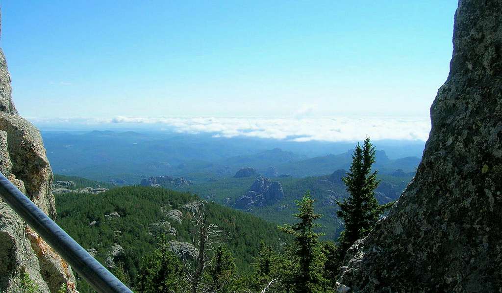
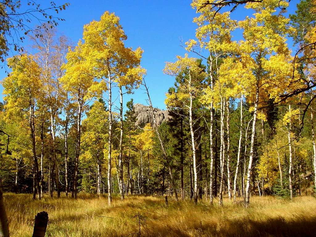
The peak is also the high point in the Black Elk Wilderness as well as the highest summit in a line between the Rocky Mountains and the Pyrenees Mountains in France. Black Elk Peak has over 2,900 feet of prominence. The mountain and surrounding range is granite that many geologists believe was uplifted during the Laramide orogeny between 40 and 60 million years ago. Although the mountain is well below treeline, the summit is mostly bare rock with uninhibited and spectacular views.
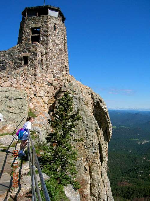
On a clear day, one can see four states – South Dakota, Wyoming, Montana and Nebraska. There is an old stone tower that was used as a fire lookout on the summit. It is no longer in use but is open to hikers. Hikers have multiple route options to reach the summit from Custer State Park and various locations in the Black Elk Wilderness. Black Elk Peak is probably the most popular hiking destination in the Black Hills.
The forest on Black Elk Peak has suffered serious damage from pine beetles in recent years, plus Winter Storm Atlas in 2013 felled many more trees. Much of the damage has been cleared away, but some still remain. The forest that remains on the peak consists mostly of Ponderosa pines, spruce, and aspens. Despite the large numbers of hikers on Black Elk Peak every year, wildlife is in abundance there, with deer, elk, bighorn sheep, mountain goats, and pronghorn antelope seen regularly. There are rare sightings of mountain lions and coyotes, but they generally do not like being around large numbers of people. Bird watchers enjoy the opportunities afforded by the variety of trails to the summit.
NOTE: Both the old and new names for this peak are listed at the top of the page for reference so that visitors to the page become aware of the official name change.
History
The Black Elk Peak area has long been inhabited by Native Americans. Various tribes have called the Black Hills home, including the Cheyenne, the Crow and the Sioux. General George Armstrong Custer led the first expedition of European Americans to explore the Black Hills in 1874.
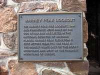 Harney Summit Plaque, courtesy Climbn816
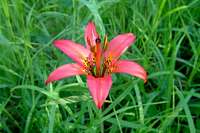 Mountain Flower, courtesy PapaBanucci
Since many native tribes consider Black Elk Peak to be a holy mountain, there have been ascents by natives in past centuries. However, the first recorded ascent was made by Dr. Valentine McGillycuddy’s exploration party in 1875. Dr. McGillycuddy later became Chief Crazy Horse’s friend and surgeon. When McGillycuddy died, he was cremated and his ashes were placed in a memorial in the new stone fire tower at the summit in 1939.
The stone fire lookout tower that stands at the summit was built by the Civilian Conservation Corp and completed in 1938. It replaced an older fire tower that was built there in 1920. In building the present tower, all the stone, cement and sand used in the tower had to be hauled up over three miles by 2-wheel carts pulled by mules and horses.
The tower served as a fire lookout until 1967. Now its primary use is a destination for hikers and occasional horseback riders that come up Trail 9 North. Black Elk Peak is the site where the Lakota Holy man, Black Elk, received his "great vision" when he was only nine years old in 1872. He later returned as an old man with John Neihardt, to whom he told his autobiography: Black Elk Speaks in 1932.
| "I was standing on the highest mountain of them all, and round about beneath me was the whole hoop of the world. And while I stood there I saw more than I can tell and I understood more than I saw; for I was seeing in a sacred manner the shapes of all things in the spirit, and the shape of all shapes as they must live together like one being." Black Elk described his Great Vision on Okawita Paha (Harney Peak) |
Just below the tower, attached to one of the few pine trees on the summit, are colorful prayer flags and other offerings. The Lakota still come here for religious ceremonies. Visitors to the mountain are asked to not disturb the prayer cloths. The Lakota Sioux call the mountain Hinhan Kaga Paha. Many Native Americans have long desired the mountain’s name be changed.
But not all are in agreement as to what it should be called. Some wanted it to be called Black Elk Peak. Others wanted it changed to Hinhan Kaga (Making of Owls). However, after five public hearings across the state conducted by the South Dakota Board on Geographic Names, the board reversed their initial plans to change the name and instead recommended to the federal board to retain the name Harney Peak.
However, the name was officially changed to Black Elk Peak on August 11, 2016. This change has generated great controversy in South Dakota, due to the fact such a large percentage of the citizens expressed their desires to have the name remain as "Harney Peak". The state still has the option of leaving the peak named "Harney Peak" on state maps. Only time will tell the direction of this issue in South Dakota.
Getting There
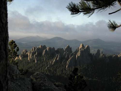 Cathedral Spires View, courtesy predator24
The directions below are from Rapid City. For the Sylvan Lake approach, take Highway 16 west for about 30 miles to Hill City, SD. Drive through Hill City on Highway 16, and about 3.2 miles out of town turn east onto Highway 87. Follow this for 6.1 miles to Sylvan Lake recreation area on the north side of the road, which is in Custer State Park.
Trail 9 South and Trail 4 both start at different places along the large parking lot on the east side of Sylvan Lake. For the Willow Creek approach, take the same drive to Hill City, and then follow Highway 16 south out of Hill City, SD, and after 3 miles out of town, turn east onto Highway 244. Follow this for about 3 miles to the Willow Creek Horse Camp on the south side of the road. The trail starts on the east side of the day-use area.
Not many hikers use Norbeck Trail 3 or Grizzly Bear Trail 7 to reach Black Elk Peak, but the trailheads for both of those trails are located along Forest Road 345, which can be accessed from Highway 87, the Needles Highway eight miles southeast of Sylvan Lake.
Red Tape
 Black Elk Registration, courtesy panhandletrails
No climbing permits are required. Black Elk Peak is located in the Black Elk Wilderness, within the Norbeck Wildlife Preserve in the Black Hills National Forest. There is a counter at the trailhead that records all people coming through.
Free maps can be found at the Forest Service offices in the area. Though Black Elk Peak lies in the Black Elk Wilderness, the Sylvan Lake trailheads are in Custer State Park. Custer State Park requires a per-person and/or vehicle entry fee. Those rates often change, so to access their latest up-to-date entry permit information, please visit the link below for complete details. Custer State Park Entrance Permits
When To Climb
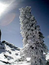
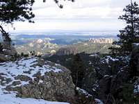 Snowy Summit, courtesy odogg0824
Black Elk Peak can be climbed year-round. The crowds are larger between April and October, with summer weekends seeing the heaviest trail use. The peak and surrounding wilderness offer a cool escape from the summer heat. Common sense will keep careful hikers off the mountain during times of hail and lightning, or winter blizzards. For the latest information on weather for the Black Elk Peak area, click on the link below
: Black Elk Peak – Custer Area Weather Forecast & Conditions
Route Options
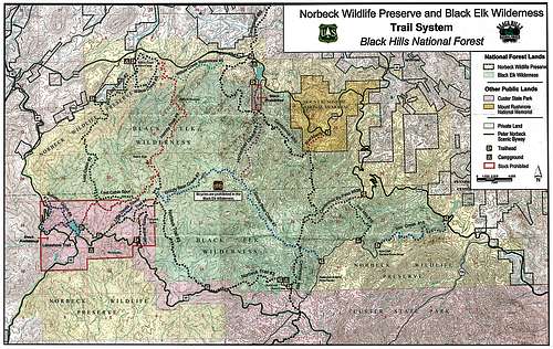 Black Elk Wilderness Map, courtesy BHNF
There are multiple routes to the summit and the Black Elk Wilderness Map (free map from Black Hills National Forest) details those routes. The most commonly-used route is Trail 9 South from Sylvan Lake. This route is approximately 3.8 miles one way (BHNF figures) with about 1,000 feet of relative elevation gain from trailhead to summit. I would rate this hike as easy to moderate.
This trail receives heavy use. Trail 4 from Sylvan Lake also sees quite a bit of traffic, because it is about the same distance to the summit, but follows a more southerly route by the Little Devils Tower and Cathedral Spires, with short spur trails to each. Trail 4 also has a second trailhead along the Needles Highway about 1 mile southeast of Sylvan Lake. From Sylvan Lake to where Trail 4 joins Trail 3 (which then joins Trail 9 South), is listed by the BHNF as 2.3 miles.
From that junction, it is approximately another 1.4 miles further to the summit of the peak. The northern approach is longer and more difficult and receives less use, but is more scenic. This route starts at the Willow Creek Horse Camp and follows Trail 9 North for 5 miles one-way to the summit, with about 2,200 feet of relative elevation gain. This trailhead is also easier to access from the Rapid City area than the southern route. Both trails are well marked and easy to follow.
 Trails Junction, courtesy panhandletrails
Two less-commonly used routes to the summit are the Norbeck Trail (Trail 3) and the Grizzly Bear Trail (Trail 7). Both trailheads are accessed from Forest Road 345, which is about 8 miles southeast of Sylvan Lake on the Needles Highway. The Norbeck Trail is listed at 6.3 miles from the trailhead to the trail junction with Trail 9. From there, it is another .5 mile to the summit. There is about 2,100 feet of relative elevation gain to the summit.
 You know you are almost there when..., courtesy El_Capitan
The Grizzly Bear Trail is listed as 6.3 miles from the trailhead to the junction with Trail 3. From that junction to the summit is another .8 mile. The relative elevation gain from the trailhead to the summit is approximately 2,200 feet. Other trail options (longer yet) would include the Lost Cabin Trail (Trail 2) from the Willow Creek Horse Camp to Trail 9 South and on to the summit.
Another route would follow the Horsethief Lake Trail (Trail 14) to the Grizzly Bear Trail, then on to Trail 9 South and the summit. These routes are shown on the Black Elk Wilderness Map & Trail Guide, published by the Black Hills National Forest. These free maps can be found at many ranger stations and visitors centers in the Black Hills.
Camping & Lodging
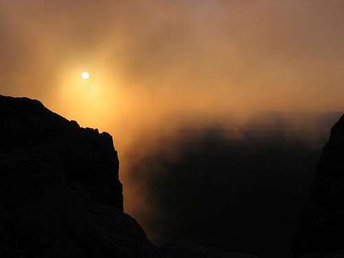 Summit Sunrise, courtesy predator24
No camping is permitted in the day-use area at Willow Creek, but you can simply grab your tent and walk a little way into the forest, and camp there. The NFS prohibits camping within a quarter-mile of the summit. There are a lot of great locations north and south of the summit.
For more on the National Forest rules on back-country camping, click on this link:
Black Hills National Forest Back Country Camping Regulations & Information.
Custer State Park and the nearby communities of Custer and Hill City have visitor websites with up-to-date links for campgrounds and lodging. You can access them by clicking below:
- Custer State Park Campgrounds & Lodging
Managing Agencies
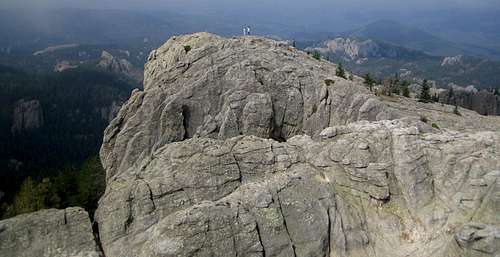 Summit Area, courtesy TLP
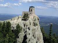 Summit Tower, courtesy dkeating2112
For up to date information, you may contact: Black Hills National Forest Hell Canyon Ranger District 330 Mt. Rushmore Rd. Custer, SD 57730 (605) 673-4853
Custer State Park 13329 US HWY 16A Custer, SD 57730 (605) 255-4515
Useful Maps
 Summit Tree, courtesy RModelli
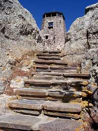 Lookout Stairway, courtesy bblack99
The following maps are useful for Harney Peak: -Black Elk Wilderness and Norbeck Wildlife Preserve -National Geographic Black Hills South -Black Hills National Forest -Trails Illustrated, Black Hills Southeast -Sierra Club, Norbeck Wildlife Preserve -USGS 7.5, Hill City -USGS 7.5, Custer
In Recognition
 Haliku
In memory of Haliku, the creator of this page and a respected SP member who lost his life in an ice climbing accident in 2010. Thanks to dkeating2112 for the initial work on this page.
Alpinist - Aug 10, 2009 1:00 pm - Voted 10/10
USGS MarkerThe USGS marker is located on a mound 300ft to the W-NW of the lookout tower. It looks lower than the base of the tower, but then why is the USGS marker there if it is not the actual highpoint? I wonder how many people miss that.
Stansbury - Sep 15, 2009 5:48 pm - Hasn't voted
USGS MarkersYour question raised my curiosity as well. Here are two possibilities. It may be the high point but, like you, I don't think so; we'll likely never know for sure. Alternatively, it may be roughly equal in elevation and if you saw the remains of some prior structure there next to it I'm guessing it was an antenna that was placed on the summit a while back to assist with other measurements. It may be that they chose a point that afforded better triangulation to other peaks as that's part of the purpose of those markers.
jhculbert - Jun 28, 2011 10:26 pm - Hasn't voted
The True High PointMost hikers assume the old lookout is the end of the hike. They are not looking for the actual natural high point on the peak to the west which has the benchmark.
jhculbert - Jun 28, 2011 10:35 pm - Hasn't voted
Trails to Harney PeakThe main description page is a bit vague on the trails to the peak. From the trailhead parking lot Trail 9 goes north, and is the shortest and most popular route. However, Trail 4 will also take one to the top, but it is a little bit longer than Trail 9. Trail 4 begins with a 1/2 mile segment leaving from the east side of the main trailhead parking lot that goes to the trailhead for Devils Tower alongside State Route 87. From that DT trailhead, Trail 4 then goes through a large, recently logged area (as of June 2011), which is not nearly as nice as Trail 9. The signage for both trails is good.
mtzfamily - Jul 13, 2013 6:54 pm - Hasn't voted
Cost and other infoThis peak is in Custer State Park. There is a $15/vehicle entrance fee that is good for 7 days in any South Dakota state park. Camping in the park is available but if you want to stay in park campground make reservations ahead of time. Cabin reservations require a minimum of 2 days advance notice. We hiked up trail 9 and out trail 4. We went up the tower and then out to the benchmark. Our GPS recorded 7.98 miles and elevation gains of 1517 feet.
Bark Eater - Sep 16, 2014 12:07 pm - Voted 10/10
$15 per carAs previously noted, access is now $15 per car. Well worth it!
AJS714 - Dec 26, 2014 4:53 pm - Voted 10/10
USGS MarkerI am thinking that the markers that are to the W NW of the lookout tower are lower than the tower. One of the markers does say Harney Peak with an arrow pointing back to the SE, just S of the lookout tower. When you are at the entrance of the lookout tower and you look back to the S SE (where you came from) you will see some rock spears or spires. This I do believe is the top of Harney Peak. I didn't see anyway of climbing to the top of it. Hope this will help.
rob_runkle - Aug 27, 2017 4:29 pm - Hasn't voted
Custer State Park feefee is now $20
adventureharder - Jun 5, 2019 10:05 am - Hasn't voted
Updated Surveyhttps://www.klkntv.com/story/40585600/lincoln-man-measures-one-of-the-tallest-mountains-in-south-dakota-makes-startling-discovery