

-
 279129 Hits
-
 97.14% Score
-
 67 Votes
|
|
Mountain/Rock |
|---|---|
|
|
44.67426°N / 121.79958°W |
|
|
Jefferson & Linn |
|
|
Mountaineering |
|
|
Spring, Summer, Fall, Winter |
|
|
10497 ft / 3199 m |
|
|
Overview
 Mount Jefferson from Detroit Lake. Photo: calebEOC
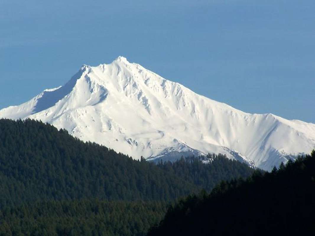
Mount Jefferson is the second highest peak in Oregon and because of its summit pinnacle requiring Class 4 scrambling on very steep, usually ice-encrusted rock, it is considered by some to be the most difficult of the higher volcanoes (above 10,000'). With over 5,777 feet of prominence, Jefferson is one of the 57 ultra-prominent peaks of the contiguous United States and is only one of four peaks on this list from Oregon. The other three are Mount Hood, Sacajawea Peak & South Sister with 7,679, 6,388 and 5,588 feet of prominence, respectively. In addition to its ultra-prominent status, Mount Jefferson lies on the Jefferson-Linn county line and is the highpoint of both of these counties, making it a "Two-Fer" county highpoint.
Jefferson is a likely extinct stratovolcano that last erupted about 40,000 to 50,000 years ago. For those interested in the geology, eruptive history, and geomorphology of the mountain this USGS Mount Jefferson page has all the information.
The mountain was named for President Thomas Jefferson by the Lewis and Clark Expedition. The first ascent was made August 12, 1888 by Ray L. Farmer and E.C. Cross. Details of first ascent.
![The west side of Jefferson as...]()
From the west (summer)
Mount Jefferson is easily accessed via United States Forest Service roads and trails leaving from Oregon State Highway 22.
Two main approaches are used depending on the route to be climbed. These are via Jefferson Park and Pamelia Lake approaches. The easiest route to Jefferson Park is via the Whitewater Trail. The Pamelia Lake Trailhead should be used for the South Ridge and Southwest Ridge routes.
The mountain was named for President Thomas Jefferson by the Lewis and Clark Expedition. The first ascent was made August 12, 1888 by Ray L. Farmer and E.C. Cross. Details of first ascent.
Getting There

From the west (summer)
Two main approaches are used depending on the route to be climbed. These are via Jefferson Park and Pamelia Lake approaches. The easiest route to Jefferson Park is via the Whitewater Trail. The Pamelia Lake Trailhead should be used for the South Ridge and Southwest Ridge routes.
Whitewater Trailhead: From the west, drive 59 miles east on OR-22 from Salem, OR. Turn left onto Forest Road 2243 and drive 7.6 miles to the trailhead. From the south, drive west 21.1 miles on OR-22 from Santiam Junction, OR. Turn right onto Forest Road 2243 and drive 7.6 miles to the trailhead. The Whitewater Trailhead is at ~4,100'.
Pamelia Lake Trailhead: From the west, drive 60.7 miles east on OR-22 from Salem, OR. Turn left on Pamelia Road and drive 3.7 miles to the trailhead. From the south, drive west 19.4 miles on OR-22 from Santiam Junction, OR. Turn right on Pamelia Road and drive 3.7 miles to the trailhead. The Pamelia Lake Trailhead is at ~3,100'.
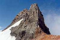
![The final obstacle to the Mt....]()
Summit Pinnacle from south
There a many routes on Mount Jefferson. All but a few are considered quite dangerous due to rockfall and avalanche hazard. Those listed here are the routes considered to be safest from objective danger. Three of these are described here on Summitpost. See guidebooks for descriptions and ratings of the more dangerous routes (Literature section below).
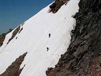
![dkantola (lower) and friend...]()
The traverse on summit pinnacle
Because of the summit pinnacle, all routes on Mount Jefferson involve at least Class 4 rock when clear of snow or very steep snow and / or rime-encrusted rock. The normal and easiest route on the summit pinnacle is from the north and is Class 4. There are other routes on the pinnacle ranging from reported 5.0 up to 5.7. All are on poor rock. If approaching the summit pinnacle from the south via the Red Saddle, a very steep snow field must be traversed in order to reach the normal route on the north side.
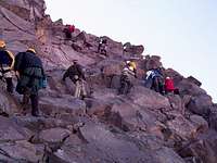
![Scrambling up the Summit...]()
Normal route on summit pinnacle dry (and crowded) conditions.
Wilderness regulations apply and the Pamelia Lake Limited Entry Area requires a limited entry permit. This permit costs $6 and only credit cards are accepted as form of payment. This link details how to obtain a permit for this area.
See the Mt. Jefferson Wilderness page for details and links regarding regulations for this wilderness.
![Mt. Jefferson on a summer eve]() Sunset
Sunset
Pamelia Lake Trailhead: From the west, drive 60.7 miles east on OR-22 from Salem, OR. Turn left on Pamelia Road and drive 3.7 miles to the trailhead. From the south, drive west 19.4 miles on OR-22 from Santiam Junction, OR. Turn right on Pamelia Road and drive 3.7 miles to the trailhead. The Pamelia Lake Trailhead is at ~3,100'.
Route Overview
General Information:
Summit Pinnacle from south
Summit Pinnacle:
The traverse on summit pinnacle
From Jefferson Park:
Normal route on summit pinnacle dry (and crowded) conditions.
- Whitewater Glacier: Grade II, glacier travel and Class 4 rock – 10 to 12 hours from Jefferson Park. This is the most popular route on the mountain. ~19 miles with ~7000' of elevation gain.
- Jefferson Park Glacier: Grade III, glacier travel and Class 5.2 rock – 8 to 10 hours from Jefferson Park. This is the second most popular route on the mountain. ~15 miles with 7000' of elevation gain.
From Pamelia Lake:
Approaching Mount Jefferson via Pamelia Lake requires a permit and entry is restricted to 20 parties per day. See the Red Tape section below for additional information. In addition, both of these routes listed below will require traversing steep snow on the southwest side of the peak below the summit pinnacle in order to gain access to the normal Class 4 route on the summit pinnacle.
- South Ridge: 10 to 12 hours from camp at Shale Lake. Similar to the Southwest Ridge route, it ascends the south ridge to the Red Saddle. ~23 miles with ~7800' of elevation gain roundtrip from the Pamelia Lake Trailhead (~3100').
- Southwest Ridge: 10 to 12 hours from Pamelia Lake. Described as "the easiest, but most tedious route" on Mount Jefferson. Scramble and hike up the long, loose southwest slope. This route is likely your best option if attempting to daytrip Mount Jefferson. ~15 miles with ~7400' of elevation gain roundtrip from the Pamelia Lake Trailhead (~3100').
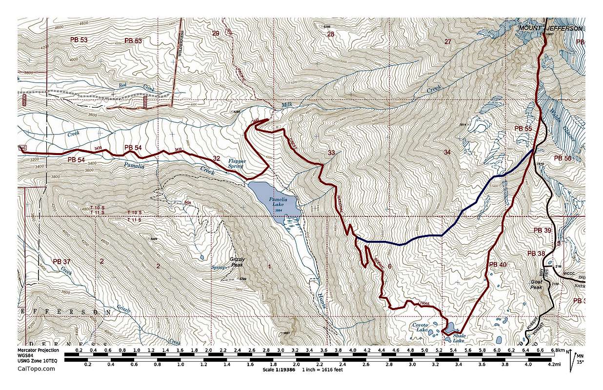
![Mount Jefferson Pamelia Lake Routes]() Mount Jefferson Pamelia Lake Routes. South Ridge (red) & Southwest Ridge (Blue). Click to enlarge.
Mount Jefferson Pamelia Lake Routes. South Ridge (red) & Southwest Ridge (Blue). Click to enlarge.
Red Tape
Mount Jefferson is located in the Mt. Jefferson Wilderness Area, Willamette National Forest.Wilderness regulations apply and the Pamelia Lake Limited Entry Area requires a limited entry permit. This permit costs $6 and only credit cards are accepted as form of payment. This link details how to obtain a permit for this area.
See the Mt. Jefferson Wilderness page for details and links regarding regulations for this wilderness.
When To Climb
The best time to climb from the North, East, and West is in late Spring when snow is plentiful and rockfall is less likely. The South and Southwest ridge routes are used year round due to limited rockfall risk.Camping
Scout Lake (~5900') in Jefferson Park is a popular place to camp for climbs of the Jefferson Park and Whitewater Glaciers. Shale Lake (~5800') is a popular place to camp for an ascent of Mount Jefferson via the South Ridge. For an ascent of the Southwest Ridge, camping at the Pamelia Lake Trailhead or at Pamelia Lake is probably best. Wilderness permits are required and some additional regulations apply to certain areas. See the Mt. Jefferson Wilderness page for details.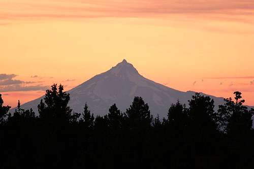 Sunset
Literature
Climbing the Cascade Volcanoes
External Links
Lists of John
peakbagger.com
cohp.org
Skiing the Cascade Volcanoes
seano - Aug 1, 2016 9:02 pm - Hasn't voted
Pamelia alternativeYou can avoid the Pamelia permit nonsense without too much work. Take FR 750 to the gate, then hike 1.6 miles to the end of the road. From there, hike uphill to the right (south) and pick up a faint trail near the ridge. You will reach the PCT in about a mile, less than a mile north of the junction coming from Pamelia.
h-bom - Apr 9, 2023 10:48 am - Hasn't voted
Re: Pamelia alternativeI was enthusiastic about this option until I found official information. The Forest Service website specifically states that permits are required even if entering at a non-trailhead. When doing so a permit must be obtained for the closest trailhead. https://www.fs.usda.gov/Internet/FSE_DOCUMENTS/fseprd1097231.pdf See section: " What if I do not use a trailhead to access Wilderness?"