

-
 50000 Hits
-
 94.44% Score
-
 47 Votes
|
|
Mountain/Rock |
|---|---|
|
|
45.94194°N / 7.86972°E |
|
|
Piemonte / Wallis |
|
|
Mountaineering, Ice Climbing, Skiing |
|
|
Spring, Summer |
|
|
15121 ft / 4609 m |
|
|
Overview
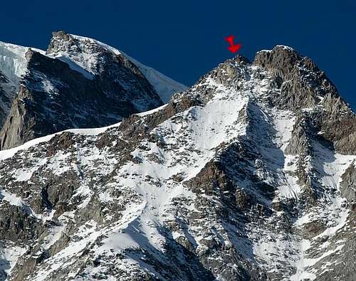
Punta Nordend 4609 m
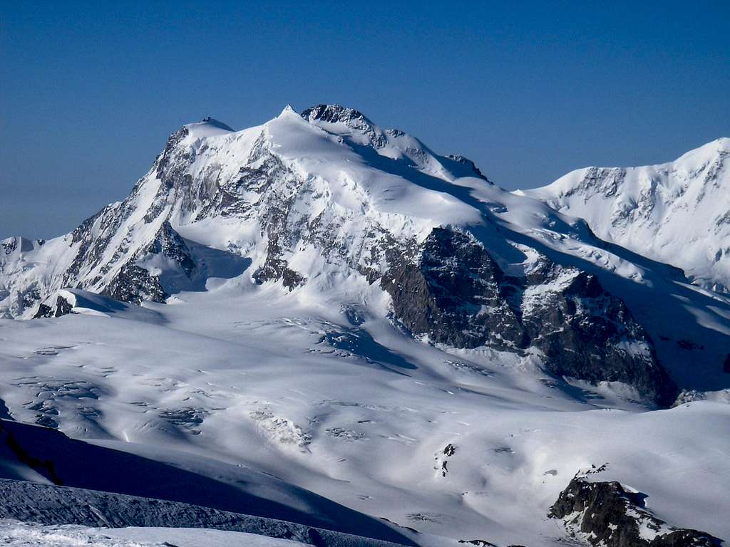
Punta Nordend 4609 m is located on the Swiss-Italian border and belongs to the Monte Rosa group. It's the Northernmost mountain of this massif. The toponym Nordend (Nord End) just indicates the Northern end of the group. Nordend 4609m is the fourth highest mountain of the entire Alpine chain after Mont Blanc 4810 m, Monte Bianco di Courmayeur 4748 m and Punta Dufour 4634 m, this latter belonging to the same Monte Rosa group.
Check here the complete list of the 82 alpine Fourthousanders and the 46 minor summits: Club4000.
It's also the highest mountain in the Piedmont Region. The Sella d'Argento - Silbersattel separates Nordend from the nearby Punta Dufour. For an overwiew of the whole massif see Monte Rosa.
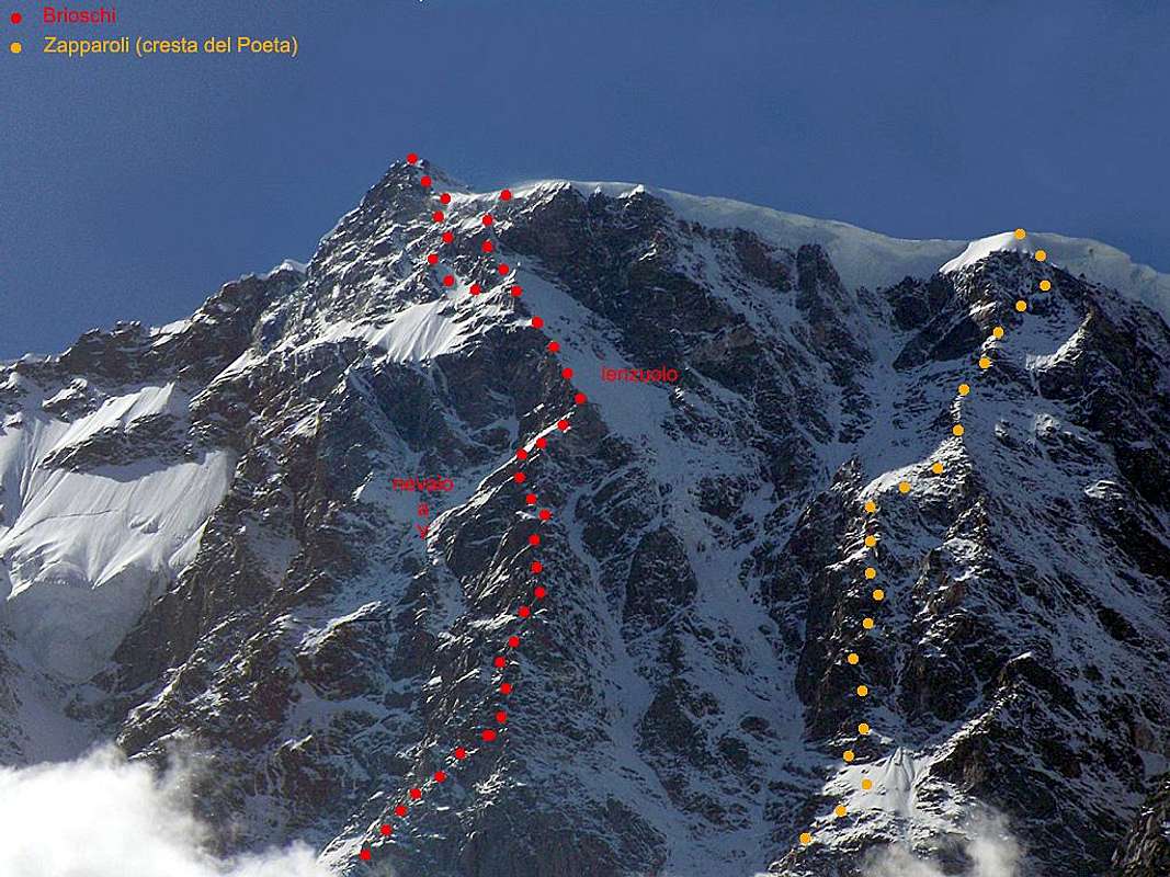
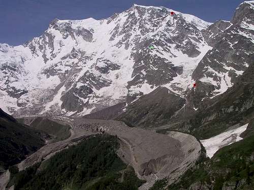
Punta Nordend shares the majestic East wall with the other summit peaks of Monte Rosa. Its highlight is a slender rocky point. Moreover Punta Nordend shows a great rocky bastion facing NW covered by a layer of ice. From this bastion it branches off towards the NE the Cresta di Santa Caterina.
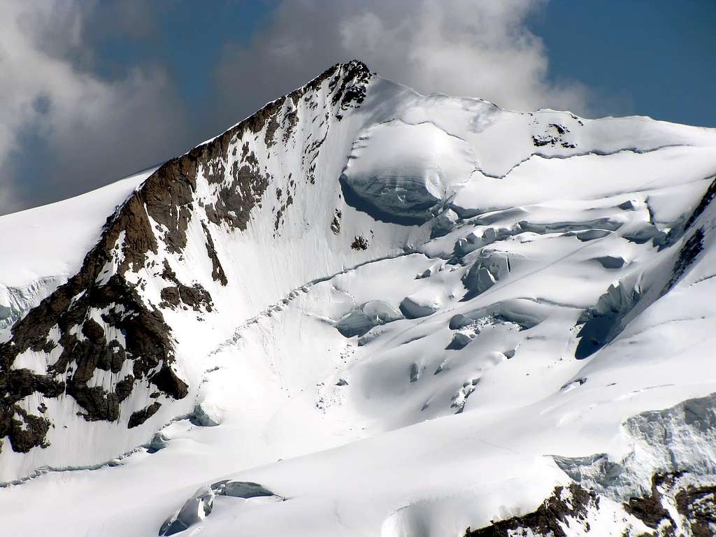
Among the four highest summits of Monte Rosa (Dufour, Nordend, Zumstein and Gnifetti), Punta Nordend is the wildest and least frequented by mountaineers, despite having magnificent ascents on snow and mixed terrain, among the most severe and longest in the Alps. Nordend is a secluded mountain, much less crowded than the nearby Punta Dufour. The acclimatization and physical effort required to climb this mountain are remarkable, given the altitude to be reached and the difference in height to overcome, from whatever side you face.
Even the Via Normale along the South ridge, although not difficult, is not to be underestimated. On the Italian side there is not a real standard route. The Swiss standard route to climb Punta Nordend can take place starting from Capanna Regina Margherita through Punta Zumstein and Punta Dufour, but it is a very demanding route that runs along very sharp high-altitude ridges. Coming instead from the Swiss Valais (from Zermatt), the ascent of the standard route starts from the Monte Rosa Hütte 2795 m. From here it is necessary to go up the Monte Rosa glacier up to the pass called Silbersattel/Sella d'Argento 4517 m, the saddle separating Punta Nordend from Punta Dufour. From the Sella d'Argento you follow the entire ridge keeping to the Western slope due to the cornices, finally some rocks lead to the top. Climbing this route from the Monte Rosa hut is not difficult, but you have to be strong and accustomed to the altitude. Excellent weather is a must. It will take you from 6 to 10 hours to climb depending on the condition of the snow and your body. The Monte Rosa glacier shows many crevasses, but these are not as mean as in the neighboring Grenzgletscher.
History
The first ascent of Nordend was performed on August 26, 1861 by F.T. and E.N. Buxton, J.J. Cowell with the guide Michel Payot along the South-South-West ridge. Among the first routes there is the first ascent of the South West Spur on 13 August 1877 by F. Morshead with Melchior Anderegg. The first winter ascent was made on 4 March 1920 by the team formed by J. Du Bois and A. Schaller along the Morshead Spur. A magnificent and challenging achievement was the Cresta di Santa Caterina (North East Crest) which was instead first climbed by V. J. E Ryan with Georg and Joseph Lochmatter in 1906.
The gigantic East face of the Nordend with Himalayan proportions was first climbed in July 1876 by Luigi Brioschi with F. and A. Imseng. The wall also includes some solo climbs carried out by Ettore Zapparoli: the Cresta del Poeta (August 1937) and the Canalone della Solitudine (September 1948). In more recent times, talented mountaineers such as Alberto Paleari, Tullio Vidoni, Patrick Gabarroux have climbed other challenging routes on the face.
Getting there
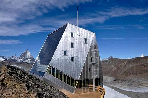
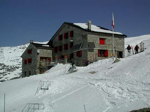
Swiss side - The best starting point to climb Nordend from the Swiss side is the Monte Rosa Hütte 2883 m. The easiest way to reach this refuge is to take the train from Zermatt to Rotemboden. It is also possible to go on foot following the road and then the path, following the signs for the Gornergrat.
- By train from Zermatt to Rotemboden. Here take the path that cuts and descends diagonally and gently towards the moraine. If there is still snow the slopes are very steep. You touch the Gornergletscer, sections equipped with ropes, poles, white-blue flags. Some sections equipped with wooden pegs and cables under the shelter due to the considerable lowering of the glacier
Normal route
Swiss Normal route from Monte Rosa Hut 2795 m
Difficulty: PD+ (Alpine scale)
Difference in level: 1850 m
Long and beautiful ascent at high altitude, in a superb environment, requires the complete glacier equipment. The first part of the itinerary is shared with the Via Normale to Dufourspitze. Although not difficult, this route is not to be taken lightly, there are cornices along the summit ridge and snow bridges that should not be underestimated on the numerous crevasses on the glacier. Furthermore, given the low attendance, there is not always a well-defined trace.
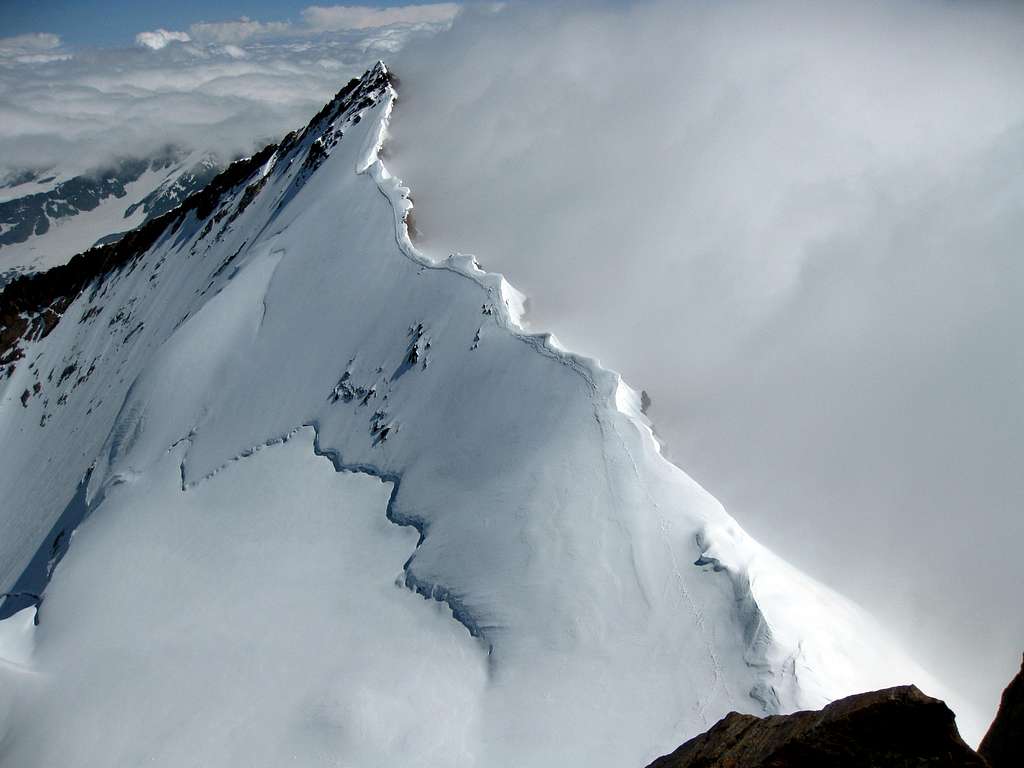
The Normal route to the summit takes place along the Swiss side starting from Monte Rosa Hütte 2795 m. It develops almost entirely on the glacier and is considered an easy climb. The first part of the itinerary is shared with the Via Normale to Punta Dufour. From the refuge, go up the moraine of the Grenzgletscher, passing from the Unter Plattje and then from the Obere Plattje 3277 m. It is wise to check it the day before at daylight, so you don't lose time in the dark of the early morning. Enter the very crevassed Monte Rosa Gletscher and follow it. You will gain the plateau at 4100 m, where the itinerary leading to Punta Dufour branchs to the right. Go up to the left along ramps depending on the conditions until you exit at Silbbersattel 4515 m, the saddle between Punta Nordend to the left and Punta Dufour to the right. The Silbersattel greets you with several bergschrunds. From here, head decidedly Northwards, following the entire snow ridge to the summit (at the end a move of II grade UIAA). Stay away from the Italian side (cornice!). The ridge is normally easy and if you climb Nordend with skis you can keep them on as far as the rocks at the end of the ridge. At the end of a dry summer the ridge is icy.
Although the difference of altitude is only 100 m from the Silbersattel to the top, even with excellent conditions you will hardly do it in less than one hour. Beware of cornices or ice on the ridge. The whole route on the glacier is highly not recommended in case of poor visibility.
Descent: reversing the same route
Other routes
East wall
Cresta di Santa Caterina
See here the fuill description: Cresta di Santa Caterina (NE ridge)
Red Tape
No fees no permits required. Be aware that the town of Zermatt has a peculiarity: it cannot be reached by car, nor can it be circulated inside by car.
To reach Zermatti you can drive to Tasch and then take the train or the shuttle.
Huts and bivouacs
1. Swiss side see Monte Rosa Hut
2. Macugnaga see Dufourspitze
3. Bivacco Città di Gallerate just below the peak of Jaegerhorn (3969m, 9 places, always open. From the Swiss side start from the upper station of the Stockhorn cable car (3405 m) and walk down to the Stockhornpass (3394 m). Traverse to the Jaegerjoch (3913 m) and climb over the rocks to the Jaegerhorn. 4 hours.
From the Italian side start from the Belloni Bivouac (2509 m, see below) and cross the Piccolo Filar glacier above the seracs
at ca. 2800 m and reach the Jaegerruecken (spur) that leads in a rather difficult rock climb (max. IV) to the top of Jaegerhorn.
6 hours.
4. Bivacco Belloni 2509 m 9 places. Take the car or bus to Macugnaga (Pecetto 1360 m).
Access via chair lift to Belvedere (1932 m). Cross the rock covered Belvedere glacier and head reach the Alpe Fillar (1974
m). Take the horizontal path in direction of the moraine and turn right on the third creek that leads to the Piccolo Fillar glacier. A small path leads on its north side to the bivouac that looks like a US mail-box. 2.5 hours.
You can, of course, reach the bivouac without the chair lift. Follow the ugly road that starts near the chair lift station. Short before Burki stay on the left (northern) side of the Anza river and follow the sign for the Sella hut. Before reaching the granite wall, you see a big waterfall to your right and a path zigzagging south of it. Leave the road and head to the waterfall where you will find this path. No sign! After a flat grassy shoulder follow the yellow sign that shows left to the Sella hut. Enter and cross a gorge. At Roffelstafel 1905 m, leave the Sella path and keep straight to Alpe Fillar where you join the path from Belvedere. 3 hours.
 |
 |
 |
 |
When To Climb
Ski-mountaineering: March to July (long days, cold, covered crevasses)
Mountaineering: July to September
Meteo
MeteoSwitzerland
Meteo Valle d'Aosta
General Information
For books, maps, webcams, trains, buses, weather, avalanches, rescue see this Swiss Links in a new window.
Guidebooks and maps
Guidebooks


 Guidebook")
"Il grande libro dei 4000" by Marco Romelli, Valentino Cividini - Idea Montagna Editore, 2015
-“Monte Rosa” by Gino Buscaini (Club Alpino Accademico Italiano) – Collana Guide dei Monti d'Italia CAI-TCI (Club Alpino Italiano-Touring Club Italiano)
"Walliser Alpen" Vol. III, Swiss Alpine Club (German and French)
-“Tutti i 4000” – L’aria sottile dell’alta quota” – CLUB 4000 CAI TORINO – Vivalda Editori
-“The 4000 of the Alps” by Richard Goedeke (CAAI) – All the normal routes to the 4000m. summits of the Alps – Libris Edition
-“Le Alpi Pennine, le 100 più belle ascensioni fra il Gran San Bernardo e il Sempione” by Michel Vaucher - Zanichelli Editore“
-“I Quattromila delle Alpi” by Karl Blodig and Helmut Dumler – Zanichelli Editore
-“100 scalate su ghiaccio e misto” by Walter Pause – Gorlich Editore
Maps

"Breuil/Cervinia-Zermatt" Kompass map 1:50.000
"Cervino-Matterhorn e Monte Rosa" n. 5 - Istituto Geografico Centrale map 1:50.000
"Matterhorn - Mischabel" n. 5006 map 1:50'000
"Zermatt" n. 1348 map 1:25'000
External Links
- Nordend at www.4000er.de
Images, routes, coordinates and more information about the highest peaks of the Alps