
-
 54845 Hits
-
 91.28% Score
-
 36 Votes
|
|
Mountain/Rock |
|---|---|
|
|
15.5457°S / 72.6607°W |
|
|
Mountaineering |
|
|
Spring, Fall, Winter |
|
|
21079 ft / 6425 m |
|
|
Overview
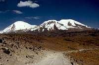
Coropuna From the West

From Laguna Pallacocha

Coropuna Topo Showing West Rib and SW Face Route

West Rib Route
Coropuna is a long, large extinct volcanic mountain located in the Cordillera Occidental of the Andes in Southern Peru. It is situated on the high plain between Chuquibamba and Cotahuasi, in the department of Arequipa. It has six peaks shown on the map at over 6,000 meters. There are various elevations given for the summit, but the commonly accepted one is 6,425 meters (21,079 feet). It was once thought that it might be the highest mountain in the Americas, but Hiram Bingham and the members of the University of Yale archaeological expedition were disappointed to find out that it wasn't, when they climbed and measured it in 1911. You can read about their expedition here. American school teacher Annie Peck actually climbed the mountain ahead of them, earlier in the year, but according to Jill Neate in “Mountaineering In The Andes”, she climbed two lower peaks, placing a 'Votes For Women' banner on one of them. Neate gives much higher elevations than other sources, as did Bingham.
Coropuna, which Bingham says comes from the Quechua coro meaning “cut off at the top” and puna meaning “a cold, snowy height”, was a very sacred mountain to the Incas. I have read of many archaeological sites around the base of the mountain, and on the slopes of it, but have not personally seen any. Tatraman mentions some on the west rib route in one of his comments. There are pre-Inca ruins on the north side of the mountain at Macua Llacta.
Getting There

The Glacier To the Left of the Summit

The Start of the Snow

Shows Angle of Climb

In the Snow Above the Rocks

Just Down To the Rocks

A Quick Trip Down
From Chuquibamba the (sometimes rough) gravel road climbs up to about 13,000 feet to the high plain, where you get your first view of Coropuna, the Chila range, and if the weather is clear, Ampato. When you reach the rim of the canyon, there is a cell phone tower up above on the left. Continue straight at the junction, the small road going to the right goes to Pampacolca and around the east side of Coropuna. About an hour from Chuquibamba, the road drops down and crosses a small stream at Rata. There isn't any bridge; the road just goes through the water. This usually isn't a problem but during the rainy season the water can be up to a foot deep, however the roadbed is solid. After the stream crossing, turn to the right in front of the shell of a building (which may have people living in it).
There is a road going left that goes to Andaray. Take the right fork at the next junction; there is a sign there that shows 116 Km to Cotahuasi. Soon after this you will see some small trees, the only ones that grow on the high plain and somehow thriving in between the rocks. If they aren't covered in dust, you can see their reddish bark, something like a manzanita tree. The road continues to wind around, and up and down, as it goes around the south and west side of Coropuna. You will also be able to see Nevado Solimana off to your left around this time.
There are two small roads branching off to the left, both of which go to the village of Salamanca, in a canyon below Solimana. There are often alternate routes, some are parallel paths, and some are shortcuts, if in doubt stick with the most traveled or main road. Coropuna will continue to loom larger and closer on your right as you go around the constant curves and through the many quebradas (dry gulches or small canyons). As you get closer to the mountain, the hills will turn to many shades of red and yellow, besides the normal brown and black. About two to two and a half hours from Chuquibamba the road drops down a bit and Coropuna will not be visible. On the left will be a dilapidated building, with some of the corrugated concrete roof missing.
The climbers who take the public bus get off here. If you are driving, continue about five minutes past here. You will go around a right hand curve and be heading more towards the mountain. There will be a minor dirt road going off to the right, turn here. Immediately you will come to a fork in the road. The right fork goes down to the lake, if you want to camp there. The left fork goes to the highest base camp at 16,470 feet, which is just before the end of the road. There are less rocks here and many good tent sites, with a large boulder to shelter somewhat from the wind. There are many vicuña in the area, they are often seen around the mountain, especially in the swampy area below the lake.
The 'road' does continue for a while but it was not possible to drive much farther because of a rock-strewn gully, just a few minutes from the base camp. We hiked up the road until that turned to go around the west end of the mountain at about 17,000 feet. From there we followed a faint climber's trail towards the west rib, which is the main route to the summit. Our route took us off to the left and followed an undulating ridge, rather than going directly towards the west rib, because there is a deep gully there and the climb up out of it would have been in steep, loose sand, however this is the fastest way to come back down.
When To Climb, Cautions

Fresh Snow on Coropuna
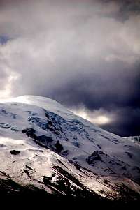
Storm Clouds
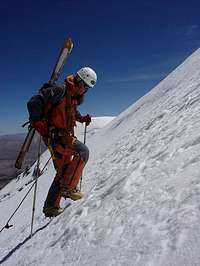
Heading Up the SW Face
During the rainy season, from January to March, the weather is often unstable, with some sunny days but storms can roll in very quickly, and the mountain will be covered in clouds, with rain and snow. The later half of December and the first half of April can get some bad weather as well, but most of the rest of the year will usually provide sunny days and clear cold nights.
It is not a technically difficult mountain to climb, the biggest problems are penitentes that get increasing larger during the dry season. There is some crevasse danger, but they are easily avoided on the west rib route. Unless it is fresh, the snow is quite hard and icy, crampons and an ice ax are normally necessary as it is about a 45° angle if you go straight up the rib.
There usually isn't any water above Laguna Pallachocha, although in the afternoon you may be able to find a stream coming down from the glacier to the left of the summit. Often times you can hear water here even though none is readily visible.
If you start at the high base camp, the mountain can easily be climbed in two days if you are in good shape and are acclimated to the altitude. Due to the high elevation, I would recommend that you do some lower peaks first. The first time I climbed it, I did it with climbing friends from Lima. We did not do any other mountains first to prepare, it took us three days and was really hard.
Camping, cellphone reception

Our High Camp, Near Sandy Bowl

Base Camp At the End of the Road
Camping is permitted anywhere in the area. There are three buses that pass through during the night, so if you aren't arriving on one of them, I would recommend camping at the lake or near the end of the road at the highest base camp. On the climb, there is decent camping in a sandy bowl, just before climbing up to the west rib, and there are a couple of higher campsites in the rocks, before reaching the normal snow line.
There should be Claro cellphone reception higher on the mountain, certainly on the summit, as it is line of sight to their tower above Chuquibamba. There is no Movistar reception anywhere on the high plain between Chuquibamba and Cotahuasi, as their towers are down in the canyons.
Nearby Attractions
Cotahuasi Canyon

Ccosla Hot Springs
About three hours past Coropuna, is Cotahuasi Canyon, and the village of Cotahuasi. This is a good place to spend a few days before your climb if you need to acclimatize to the altitude. There are many lower mountains, from 12,000 to 17,000 feet, enough trails to keep you busy for weeks, and plenty of natural attractions such as waterfalls, hot springs, rock and cactus forests, as well as traditional villages surrounded by terraced fields. Check out the above linked pages to find more information.
Other Nearby Mountains

Nevado Solimana

Nevados Ampato, Sabancaya and Hualca Hualca
Just an hour and a half past Coropuna, is Nevado Solimana, which at 6,093 meters, is just 10 feet short of 20,000 feet. It is a harder climb technically, and is best climbed in May or June when there is more snow, which is needed for the normal route. North of Coropuna is Nevado Firura (5,498 meters - 18,038 feet), a rarely climbed mountain requiring a long approach hike, but an easy summit climb, at least when there is lots of snow.
In addition to these, there are all the mountains near Arequipa and Colca Canyon, including El Misti, Chachani, Ampato, and many others. See the links at the left, as well as the Volcanoes of Arequipa page, for more information.
tatraman - Feb 23, 2004 2:06 pm - Hasn't voted
Untitled CommentI recomend Carlos Zarate as a good guide for climbing in this area. he is from a famous mountainnering company from Arequipa. and has a lot of experience. Is also helpful in providing information.
Contact:
CARLOS ZARATE "AVENTURAS" E.I.R.L.
Calle Santa Catalina 204 Of.3
Telefono: +51-54-202461
Telefax: +51 54 263107
e-mail: carlos@zarateadventures.com
This is definitely an outfitter for Arequipa area (Ampato, Coropuna, Chachani, El Misti and others...
tatraman - Oct 23, 2004 6:48 am - Hasn't voted
Untitled CommentI suggest everyone climbing in this area to visit Canon de Cotahuasi which is more remote but more beautiful than Colca. Termal spa is to be found there, as well as caves, waterfalls and other nice places.
tatraman - Jun 30, 2005 3:54 am - Hasn't voted
Untitled CommentHiram Bingham was actually the first to climb the main summit (even though Incas suposedly did so 400 years before him) Coropuna is one of the most sacred mountains worshipped by the inca and pre inca cultures. Apu Coropuna - mountain ghost was offered human sacrifices in the Inca times as its anger was meant to be reason of volcanic activity and earthquakes those days... me an d my friends found some inca time bundle-like remnants halfway up the rocky section of the W rib route when climbing it in early december 2001. They may be covered by snow early in the season but at the end of the dry season, they should be visible. To me they appeared as animal skin bundles on a flat platform made of stones. might be of archeological interest. When approaching the SW face of the mountain, we encountered a stone -paved path partially destroyed by earthquakes leading towards the slopes of the mountain. At a place called Arma (halfways from Chuquibamba to Cotahuasi), there are remnants of Inca time aquaduct that fed the arid valleys with glacier water.
From this place, you can head to Mauca llacta willage with Inca and pre-inca time ruins...
So if you go to Coropuna, do not forget to make the chicha (local alcoholic beverage) and leafs of coca offerings to Apu Coropuna to ensure a good welcom e of the sacred mountain
Mike N - Sep 6, 2005 10:14 pm - Hasn't voted
Untitled CommentI suggest getting private transportation as the bus ride is long and unpredictable when they will pick up. The drive by car takes 7 hours. From Arequipa, take the road that gets you to the Pan American Hwy to Lima. After passing some kiosks and stands, there is a road that veers off to the right across a "pampa" to the Majes Valley. You descend into the Valley and cross the river, passing through several small towns. You then start climbing out of the Eastern end of the Valley. The last town you go through, and the last place for fuel, food, or water, is Chuquibamba. It is then two hours before getting to Basecamp of the standard route. The road here on out is gravel and rough. The road will approach very close and almost seem to top out near Coropuna. There will be a dirt road that comes off to the right. It is then a 10 minute drive to basecamp. Depending on snow levels you may or may not get there. It is well protected from the wind and is flat. There are several tent sites. The climb can easily be seen. The glaciers and ice falls are also seen.
Vic Hanson - Oct 18, 2005 12:18 am - Hasn't voted
Untitled CommentI agree, visit Cotahuasi Canyon, it is a beautiful place with lots of hiking and peaks up to 16,000' with the trail heads in the village of Cotahuasi. I live there, feel free to email with any questions or if you want to visit.
k_egg - Aug 30, 2014 1:32 am - Hasn't voted
Guide agency as of AUG 2014I tried several of the numbers and emails listed for guides/agencies and had no luck. I finally walked into Peru Adventure Tours and the folks there hooked me up. Coincidentally, the guide they found for me (his name is Angel, pronounced with a soft "g") had just taken me and a couple of Italians on a 2-day up Chachani. In total I paid 1060 Soles (~370USD) for the trek, which I think is pretty reasonable considering most other places quoted something like 600USD for a single climber. What I paid includes bus, and gear rental, but not food (I needed a lot of gear as this wasn't meant to be a mountaineering trip to Peru). The contact information for Peru Adventures, as of 29 AUG 2014, is: Movistar: 973842688 Claro: 959767193 https://www.peruadventurestours.com/en/arequipa/coropuna_mountain.html Their office is at Ugarte 109. It's about a 6 or 8 minute walk from the main plaza.
Vic Hanson - Sep 20, 2014 7:57 pm - Hasn't voted
Thanks, K eggI need to apologize for the outdated guide information. I left Peru in the beginning of 2010 and haven't been able to update any of the information since then. Thanks for the information you provided. Vic