
|
|
Mountain/Rock |
|---|---|
|
|
47.77470°N / 121.58°W |
|
|
5979 ft / 1822 m |
|
|
Overview
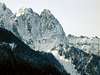
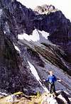
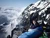
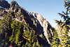
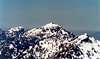
Mt. Index is a Cascade Range classic. The views of the mountain from HWY 2 are awesome and seen by many each year. There are three peaks to the legendary summit ridge, commonly known as the North, Middle and Main Peak. Even though the approach is fairly close to civilization, not too many folks climb the mountain in any given season. The easiest route on the main peak is somewhat "non-technical" and is approached from the west and a moderate scree/snow climb doable in a day for a determined and fit hiker.
However, the standard route uses the east and southeast sides. See the Hourglass Gully route page.
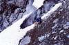
The Middle and North peaks are only accessible via committing technical climbs with the easiest being a Grade III, 5.7 on vertical dirt, somewhat rotten rock, and thick brush in areas on the North Face of the North Peak.
 |
 |
 |
 |
 |
A little piece of Cascades Trivia:
Famous Pacific Northwest helicopter pilot Tony Reece was married on Mt. Index's south slope/ridge. See seventh post in this thread.
Getting There
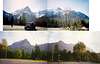
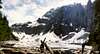
From I-5 in Western Washington, drive east on HWY 2 from Everett through Monroe, Sultan, Startup and Gold Bar. Approximatly 12.8 Miles East of Sultan turn Right onto the road marked "Mt. Index Road". If you cross the old bridge across the Skykomish River, you've gone a little too far.
The trailhead is approximately 1/4-mile up the Mt. Index Road; stay to the right at the Y.
To get to the west side follow the same directions except you exit HWY 2 on Forest Service Road #62 (approximatly 6 miles east of Gold Bar and maybe one mile west of the bridge over the Skykomish. Stay to the left at the first Y then to the right at the 2nd Y (if you go left at the second Y you'll find yourself at the Mt. Persis Trailhead). Drive until you reach the large washout at the head of Proctor Creek. This is a brushy route that traverses over or near "Persindex" (Pk 5360+). Expect a long day.
 |
 |
 |
Red Tape
NW Forest Parking Pass Required for the trailhead.
When To Climb
Usually climbed from late April through Early October. Can be a memorable winter climb if conditions are stable.
 |
 |
Camping
Camping allowed near but not on the shores of Lake Serene which is 2200' and 3.6 miles from the trailhead, near the approach to the N. Ridge of the N. Peak route.
 |
 |
 |
 |
 |
Mountain Conditions
 |
 |
 |
 |
 |
External Links
- Stevens Pass Web Cam
Closest Web Cam I know of to Mt. Index. Stevens Pass is at 4,000' elevation and about 20 miles east of Mt. Index. - Climb of the North Peak
Bronco - Dec 17, 2002 1:46 pm - Hasn't voted
Untitled CommentThis link is to conditions for the Steven's Pass Ski Area, (elevation 4,000') approximatly 23 miles East of the Mt. Index Peaks, but, it will give you an idea of what conditions could be on Mt. Index if you are considering a winter climb.
http://www.stevenspass.com/html/misc/webcam.shtml