
|
|
Mountain/Rock |
|---|---|
|
|
38.51470°N / 109.2217°W |
|
|
12272 ft / 3741 m |
|
|
La Sal Mountains Overview
Click to see an Overview Photo of the La Sal Mountains.The La Sals are a small mountain range in eastern Utah covering an area 25 miles long (north-south) by 15 miles wide (east-west). They are, however, Utah's second highest range (after the Uintas) and contain twelve peaks higher than 12000 ft (highest point: Mt. Peale 12721 ft). With their lush forests and cool summer temperatures, they are a sharp contrast to the hot, arid canyonlands of eastern Utah and provide an excellent background for the dramatic scenes of Arches and Canyonlands National Parks. Two high passes, La Sal Pass (10125 ft) and Geyser Pass (10538 ft) divide the mountains into three distinct groups: north, middle and south.
North has seven 12ers:
Rank....................Peak
4...........................Mt. Waas (12331 ft)
5...........................Manns Peak (12272 ft)
7...........................Mt. Tomasaki (12239 ft)
8...........................Pilot Mountain (12200 ft)
9...........................Green Mountain (12163 ft)
11.........................Castle Mountain (12044 ft)
12.........................La Sal Peak (12001 ft)
Middle has five 12ers:
Rank....................Peak
1...........................Mt. Peale (12721 ft)
2...........................Mt. Mellenthin (12645 ft)
3...........................Mt. Tukuhnikivatz (12482 ft)
6...........................Mt. Laurel (12271 ft)
10.........................Little Tuk (12048 ft)
South has no 12ers:
Rank....................Peak
17.........................South Mountain (11817 ft)
Canyon Country's "La Sal Mountains, Hiking and Nature Handbook" by Jose Knighton, with its accompanying map, provide an excellent guide. Make sure you buy the map. Without it, the book becomes confusing.
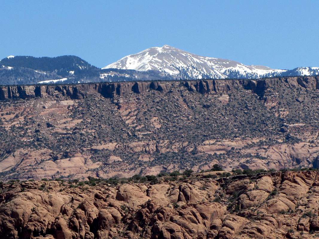
West face of Manns Peak. From a spot just south of Moab
Manns Peak Overview
 Manns Peak is the second peak from right

Manns Peak is the fifth highest peak of the range and can be easily accessed via its gentle southern slopes. These slopes rise above the 11180 ft Burro Pass which can be reached from the west via Warner Lake or from the east/south via a trail that starts on a branch of Geyser Pass Road.
From the summit of Manns Peak, you can see nine of the twelve peaks that are higher than 12000 ft (10 if you count Manns Peak). Unlike the gentle southern slopes, the northern slopes of Manns Peak drop very steeply into the upper portions of the Beaver Basin 1500 ft below (all very loose rock). To the north and west, green mountain slopes gradually merge into red arid lowlands. Spanish Valley, where Route 191 runs, resembles a long, deep trench cut into the redlands below. Moab can be seen as a green spot in the northern end of the trench. The canyons and mesas of the Canyonlands National Park sit beyond the trench. With its steep arching cliffs, Castle Valley appears as part of a huge crater to the north. To the east, you can see the Uncompahgre Plateau and the canyons of the Dolores River. On a clear day and with the help of binoculars you can even see some of the San Juan Mountains of southwestern Colorado.
 |  |  |  |  |
 Manns Peak
Getting There
 Manns Peak is the fourth bump from the right
The mountains are easily accessible from the town of Moab (elevation 4000ft) to the west. La Sal Loop Road is a 35 mile long paved road that travels part of the western slopes of the mountains giving access to dirt roads leading to trailheads.
Here are the directions for the Burro Pass East trailhead:
From downtown Moab follow Route 191 eight miles south to a connecting road on the west/left. Turn left on this road. After half a mile, turn right/south on Spanish Valley Drive. This road will eventually become the La Sal Loop Road. It quickly climbs the western foothills which are covered with a dense blanket of shrubs and bushes. After 20 miles from Moab, turn right onto Geyser Pass Road; a dirt road that is passable by most vehicles. Once you reach an elevation of 8500 ft, a forest of aspen appears. Farther up, the forest turns into mostly spruce. At 28 miles from Moab, you reach Geyser Pass (10538 ft). Turn left onto a four wheel drive road (not too bad a road). Descend this road, on the eastern slopes of the mountains, for one mile until you reach a two-track on the left/north, (10180 ft). This is your trailhead. The summit of Manns Peak can be seen looming above a valley to the north only 2.25 miles away (via the trail).
Red Tape
No fees or permits required. From Pilot Mtn. From Pilot Mtn. |  North Slopes North Slopes |