
|
|
Mountain/Rock |
|---|---|
|
|
42.63660°N / 118.5757°W |
|
|
Harney (County High Point) |
|
|
Hiking, Mountaineering, Bouldering, Mixed, Scrambling |
|
|
Spring, Summer, Fall, Winter |
|
|
9733 ft / 2967 m |
|
|
Steens Mountain
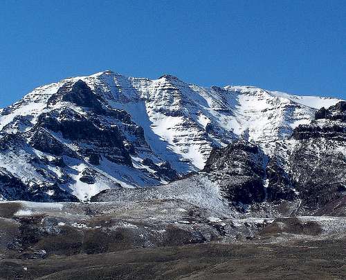
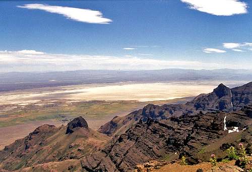
Stretching across the High Desert of Southeast Oregon is the most massive of the state's peaks. From Baker Pass in the north to Long Hollow in the south, The Steens as a mountain range is nearly 60 miles long and 18 miles across. Taken as a mountain with a nine thousand foot crest, the peak runs over eight miles from north to south. This massive fault block of basalt is the highest point south of the Three Sisters in Oregon, has 4373 feet of prominence, and is the highpoint of Harney County. The nearest higher peak is Eagle Peak, a distant 125 miles away to the west in California.
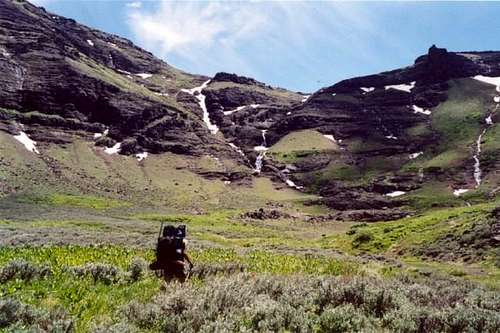
The voyage to Steens Mountain begins by traveling south into the Great Basin from Burns, where you will pass by the verdant Malheur Wildlife Refuge. You may notice as you pass the shore of Malheur Lake at The Narrows the land rising, gaining elevation almost imperceptibly until Frenchglen where the scrub and marsh lands give way to a dense juniper forest. Turning southeast here on the Steens Loop road you begin a gradual climb towards a distant ridgeline, the crest of Steens Mountain. Along the way you will climb above river canyons seeing hidden groves of quaking aspen, willows, and mountain mahogany. It isnt until the Kiger Gorge overlook that the sense of elevation really takes hold.
At this point, the dramatic 2000 foot drop from High Desert into a lush river canyon reveals that somewhere along the last 20 miles you gained several thousand feet of elevation. The summit ridgeline is one of the more magical locations in Oregon. To the east, the 5000 foot dropoff into the bleak Alvord Desert, to the west the many deep glacial river valleys, to the south the Pueblo Mountains, and along the northern horizon is the Strawberry Mountains. Far below the alpine highlands, creeks and rivers hide beaver and native trout populations that are fed by snowbanks which can survive the blistering summer heat of the Oregon Desert.
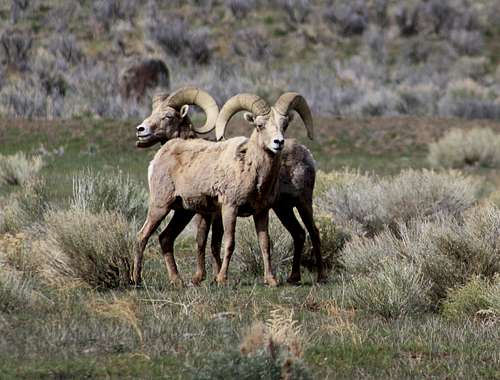
In a desert of sagebrush, coyotes and antelope, Steens Mountain is an alpine island rising above the harsh lowlands of southeastern Oregon. Here you will find mule deer and Kiger Mustangs grazing the high slopes, endangered sage grouse wandering the canyons, and elusive Rocky Mountain Elk hiding in dense northern groves above the Kiger Gorge. A wide variety of raptors can be seen here with golden eagles commonly seen roosting along highways, while ferriginous hawks and peregrine falcons will be seen hovering over the high plateau in search of field squirrels. Rarely seen are the regions Bighorn Sheep. These animals navigate the rough eastern face of Steens Mountain high above the Alvord Desert. One exception however is the Roaring Springs along the Catlow Valley. Abundant water and feed attracts Bighorns and some of the most epic Mule Deer you will ever see, and all from the highway near this rare desert oasis.
Much of the mountain is within BLM land and open to the public with some areas more accessible than others. While much of the highlands are within hiking distance of the loop road and open to the public, some of the deep gorges are privately owned by large local ranches. One notable exception is Big Indian Gorge which does have a developed trail running the length of it. However the lower Kiger Gorge and Wildhorse Canyon are inaccessible from the lowlands.
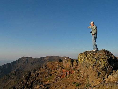
In comparing the gentle western slopes to the dramatic east face, using either side as access requires completely different levels of skill. The east face of the fault scarp drops immediately over one vertical mile to the Alvord Desert and in places would require true mountaineering ability to climb. For being comprised of basalt, the vertical rock along the east face is substantially rotten. The highest point on the mountain is a short walk on a rough (and gated) road that departs from the loop road coming up the west slopes. While a radio facility mars the absolute summit, there are many other wild peaks along the crest.
Getting There
Big Indian Gorge
Although located in the Southeast corner of Oregon hundreds of miles from any major cites, the mountain is very accessible given a tolerance for driving. Burns which calls itself the "Gateway to the Steens" offers the amenities of a large town and has a population hovering around 3000. From Burns follow State Route 205 south for about 60 miles to Frenchglen, which hosts a store, gas station, and post office in one building that is not always open; and a nice historic hotel (think bed and breakfast).
A scenic loop road (Steens Mountain National Back Country Byway) is found on the south end of town and provides easy access to the high country. Sixty-six miles in length, the first half of the loop is gravel with some washboarding and general roughness; but its usually passable in a low clearance vehicle from July until September, or even into November if snow comes late in the year. Sights that can be seen along the first part of the loop are Fish Lake, The Kiger Gorge, and the Steens Mountain Summit.
In the past the south half of the loop road had not been passable unless in a vehicle with high clearance, and four wheel drive. Recently the road has been leveled and graded, and can be driven by standard vehicles. This last half travels down the sidewall of Big Indian Gorge along a feature called the Roosters Comb offering some nice looks back towards the summit and gorgeous views of Big Indian Gorge, but much of the mountain can be seen and enjoyed without ever traveling this second half of the loop.
Unique locations along the Steens escarpment
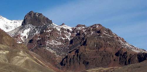
KigerMann: With 500 feet of prominence this is the highest point along the Steens Mountain crest at its northern end. At 9348 feet this point overlooks the Kiger Gorge and the "Big Nick" notch. A summmitpost page exists for this mountain and much more information can be found there including amazing pictures of the Kiger Gorge and notch. Kigermann is one of Oregon's Hundred Highest Peaks.

Point 8844
Point 8844: Located 1 mile east of the summit; on topographic maps this is marked as a nameless elevation, at 8844 feet. Seeing it from the Alvord Desert reveals that it is in fact a giant pinnacle of near-unreachable Steens Basalt. This point considered as a mountain climbed from the Alvord Desert; is quite possibly the most difficult summit to reach in Oregon.
Devine Rock: The second most visually prominent rock feature along the east face of Steens Mountain is this rotten chunk of Steens Basalt overlooking Big Alvord Creek and the Alvord Ranch. At 7782 feet Devine Rock is one of the more difficult summits in Southeast Oregon as it's protected by cliff bands on all faces. A 4x4 track can be found where Big Alvord Creek crosses the road at the Alvord Ranch. Located on the north side of the creek, gaining permission to travel on this land from the Alvord Ranch may be necessary.
Devine Rock
Alvord Peak: Overlooking Fields is this mountain at 7132 feet. Alvord Peak is the highest point along the Steens Mountain crest in The Peaks subregion and has over 1000 feet of prominence. A summitpost page exists for this mountain.
Pike Canyon: The only developed trail on the east face of Steens Mountain can be found in Pike Canyon. Detailed in William Sullivan's 100 Hikes in Eastern Oregon book; the Pike Creek trail follows an old roadbed for a couple miles up to, and beyond frontier mining sites, beyond that it is a bit of a scramble along a lightly maintained trail to the headwall of Pike Creek. Overlooking the mouth of Pike Creek Canyon is Pike Rock at 5808 feet, and at the head of Pike Creek is a series of spectacular basalt pinnacles and walls. Although not posted as such, several campsites with fire rings exist at the trailhead. Wood is not readily available, and the cutting down of trees should not be practiced at any cost, although its immediately apparent some of the aspens here have been cut down. Finally, the 4x4 road leading to Pike Creek is very washed out and can be reached by high clearance vehicles only. This road is about a mile long.
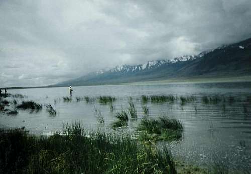
Mann Lake: Once a popular sportfishing destination, goldfish were dumped into the lake which are slowly destroying the environment for native trout. Mann Lake is one of only a couple lakes along the eastside of Steens Mountain that does not dry up. Here is a link to the Mann Lake BLM page. Update; reportedly fish and game is working on a plan to exterminate goldfish from Mann Lake.
Mann Lake
Fish Lake: What is most likely Steens Mountains most popular campground can be found at Fish Lake. Surrounded by a healthy stand of willows and aspens, here a wide variety of wildlife can be found including beavers further down Lake Creek below the lake. Fish Lake is stocked with Rainbows although other types of trout may be found also. Here is a link to the Fish Lake BLM page.

Mickey Hot Springs
Alvord Hot Springs: Unquestionably the most popular of the Steens Mountain area hot springs. Located at 4080 feet on the Alvord Desert Playa these springs are roughly nine miles north of the Andrews ghost town along the Fields-Denio road. Expect to find the pools somewhere in the range of 100-120 degrees. Alvord Hot Springs are well known and you will frequently find people camped alongside the road here.
Mickey Hot Springs: These undeveloped hot springs are usually too hot to bath or soak in, but do offer the opportunity for exploration of steaming vents, bubbling mud pots, and apparently bottomless pools of water. You will find signs posted at the site stating that the water here is excessively hot and that there have been fatalities here in the past.
Wildhorse Lake: The best known of Steens Mountain's glacially formed moraine lakes sits at the head of Wildhorse Canyon just beneath the summit. A short trail drops from the summit road down to the lake, a hike that can be done round trip in less than 2 hours from the Steens Mountain Loop Road.

Wildhorse Lake
Borax Lake: A treasure truly unique to Oregon is this 100+ degree pond hidden amidst the wastes of the southern Alvord Desert near Fields. This is the only place you can see the Borax Lake Chub, a fish that has evolved to survive in what is essentially a hot spring. Borax Lake is 10 acres, and water welling up from within it feeds a series of cooler ponds and marshes surrounding the primary spring. A series of much hotter pools can be found on the north slope of Borax Lake. Borax Lake is a great place to see migratory birds in the spring and early summer.
South Steens Rim: Three points along the Steens Escarpment have at least 1000 feet of prominence including this point directly west of Alvord Lake. The South Steens Rim overlooking Alvord Lake has an average elevation exceeding 7000 feet over the length of 6 miles not broken by canyon or pass. A route exists to the summit and explained in detail in 75 Scrambles In Oregon.

South Steens Rim
Stonehouse BM: A steep 4x4 road crawls up Stonehouse Creek and breaks across the north escarpment near Mann Lake. Stonehouse BM is 7220 feet in elevation and offers a nice view of the North Steens and Sheepshead Mountains. This is one of the few places you can drive across the escarpment, and the road passes alongside "The Stonehouse", a large blocky outcropping of Basalt.
Alvord Desert:
Alvord Desert from East Rim Overlook
The driest location in Oregon with less than 10" of annual rainfall is the Alvord Desert, which is the largest of several alluvial plains along the Fields-Denio Highway. Multiple streams running off of Steens Mountain's east face flow onto the Alvord Desert where you might find some accumulation in spring.

Borax Hot Springs
When To Climb

Stonehouse BM 7220 feet
In summer driving the loop road offers quick access to the summit via a quarter mile hike up a maintenance road. Many hikers opt to summit Steens Mountain via Big Indian Gorge which has a developed trail running the length of it. A route page exists for this option.
In winter the gentle western slopes of the Steens offer great ski touring. The loop road is a wonderful multi-day trek for just such an excursion. The loop road typically opens in June, but snowfall in this desert land can be highly variable from year to year.
Summiting the mountain via its steep eastern face should not be taken lightly. Routes are non-existent and the rock along knife-edge ridges and headwalls is surprisingly crumbly. Best access to the summit via the east face is in the region of Kigermann where ridges do not drop off so dramatically along their north and south faces. Couloir climbing may be an option, but should be approached as a multiday trek with the possibility of avalanche from giant cornices that mass along the summit crest.
Check links on the Burns BLM page for updates on the loop road conditions and when it opens.
Camping
This information has been taken directly from the most recent Harney County Informational Pamphlet available at the Malheur National Wildlife Refuge headquarters.

Sandhill Crane
Malheur Field Station: (541)549-2629
spaces for trailers and 250 dormitory beds with provided bedding and showers.
Located at the Malheur Wildlife Refuge and open year round.
Frenchglen Wayside State Park:
No camping spaces, but picnic spaces and a vaulted toilet. Frenchglen Hotel is located next door.
Located on the south end of Frenchglen.
Page Springs: (541)573-4400
36 Campsites along the Blitzen River with toilets, water, garbage service, fire rings and picnic tables.
Located 3 miles east of Frenchglen on the Steens Mountain Loop Road and open year round.
Jackman Park: (541)573-4400
6 Campsites with toilets, water, garbage service, fire rings and picnic tables.
Located 19 miles east of Frenchglen on the Steens Mountain Loop Road near Fish Lake. Open July to November based on snow conditions.
Fish Lake: (541) 573-4400
23 Campsites with toilets, water, garbage service, fire rings, picnic tables, and a boat ramp into the lake (no motorized boats permitted).
Located at Fish Lake 17 miles east of Frenchglen. Open July to November based on snow conditions.
Mann Lake: (541) 573-4400
Undeveloped campsites with vaulted toilets and a boat ramp. No water or services available. Located north of the Alvord Desert on the east side of the mountain. Open year round.
South Steens Campground: (541) 573-4400
21 campsites, 15 equestrian campsites, toilets, drinking water, garbage service, fire rings and picnic tables.
Located 18 miles up the South Steens Loop Road. Open May to November depending on snow.
Mountain Conditions
Burns District Office of Bureau of Land Management (541-573-4400)
Bighorn Sheep near Roaring Springs
Maps and Other Links
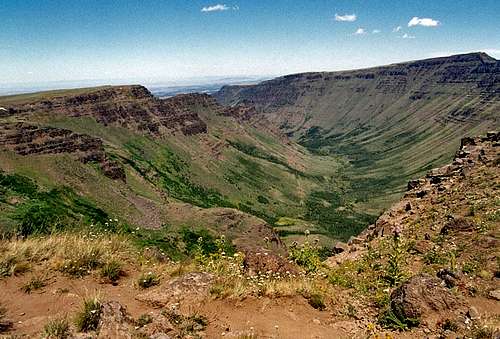
Kiger Gorge Overlook
Burns BLM Page
Malheur National Wildlife Refuge
Borax Lake on the Nature Conservancy Page
Steens Mountain Canyons
Old Steens Mountain Summitpost Page originally created by Mutant1

Summit Area Map
History
Steens Mountain is named for Eunoch Steen an Army Major who led campaigns against the Northern Paiutes on the mountain. (Oregon Geographic Names). Steens Mountain was originally called Snow Mountain back in the 19th century.
Devine Rock is named for John S. Devine, the first cattle baron to arrive into the Alvord Basin. Devine founded the Whitehorse Ranch in 1869, and later the Alvord Ranch. Both ranches continue to operate to this day. (Great Basin Country page 25)
East Rim Overlook
mpbro - Feb 12, 2002 9:16 pm - Voted 10/10
Untitled CommentSaw a recent article in Couloir Magazine about some steep, virgin gullies on Steens Mountain. I cannot find the link online (keep checking the webpage) and I forget the issue.
But the point is that Steens can be skiied, and skiied with gusto if you are up to it (50 degree couloirs currently elude me). You or someone else may add some info here if you have it.
THnaks
MOrgan
tarol - Oct 20, 2006 5:02 pm - Hasn't voted
More info on campingBLM campgrounds with drinking water and vault toilets are located at Page Springs, Fish Lake, Jackman Park, and South Steens. A private campground, gas, phone, and store is available at Frenchglen. More info here