
|
|
Mountain/Rock |
|---|---|
|
|
28.69610°N / 83.49530°E |
|
|
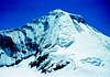
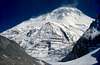
26795 ft / 8167 m |
|
|
Overview
Dhaulaghiri was climbed first in 1960 by an international team under the leadership of Max Eiselin, Lucerne. Since I happen to know some of the team members personally, my description concentrates mainly on this ascent. But in this Overview chapter, I try to inform about the present situation.
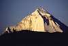
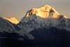
Dhavali giri is Sanskrit and means white mountain. It is located in the west central part of Nepal. On the altitude scale it is number 7 and it is almost the last 8000er to be conquered. The way of the first ascent is the normal route of today. There are however two main possibilities to reach the base camp. Both ways start from south at the small town of Beni (860 m) which can by reached by bus from Pokhara and Kathmandu.
The eastern valley is called Kali Gandaki and was chosen by the French expedition in 1950. Today there is even an airport at Jomosom (2700 m) in this valley. On the west side of this valley is Dhaulagiri, on the east side is Annapurna. The alternative route is the Mayanghdi valley, which was discovered by a Swiss expedition one year later. Today there are commercial trekking tours that climb on one side, reach the base camp and come back through the opposite valley. But there also organized tours that try to reach the summit. Here is a brief description of such a tour that lasts ca. 45 days and costs around $ 7000, including the flight to Nepal and the fee to the summit.
Reckon with a 10 days climb from Beni through Mayanghdi Khola to the BC on the north side at 4650 m. Food and lodging in tents are provided by the organizer. Porters are included in the price. The participants will spend 30 days at and above the base camp. Food will be supplied at the BC, but the ascent of the NE-spur is left to the team member, without guides and at their own risk. 2-men tents are provided, but must be carried and to four sites on the spur and are erected by the members. Some fixed ropes are already there or will be installed by the organization. Artificial oxygen is proved at the BC in case of emergency.
The route between the last camp and the summit does not follow the spur and the French ridge, as in 1960, but follows the ice field that heads directly to the summit and was abandoned by the first ascent because of too much snow.
The way back to Beni may lead over the French-Col and ambush Pass (Thapa Pass). Then follow the Kali Gandaki to the village of Tuktsche (2600 m). Some organizations walk back to Beni, others reach the airport at Jomosom (2700 m).
Literature:
Max Eiselin: Erfolg am Dhaulagiri. Orell Füssli Verlag, Zurich 1960.
Translation:
Max Eiselin: The Ascent of Dhaulagiri. Oxford University Press, London 1961
Kurt Diemberger: Der weisse Berg des Himalaya. OeAV-Jahrbuch 1960, p. 99-116
 |
 |
 |
 |
 |
Attempts
1950: At that time nobody has ever stood on a 8000 m peak. The French felt it was time for a patriotic victory after the humiliation of WW II. A large amount of taxpayers' money was supplied to a group of excellent mountaineers under the guidance of Herzog: Terray, Lachenal, Rébuffat, Oudot. Their target was Dhaulagiri. They strode with 200 porters through unknown and inhospitable regions on the Tukucha side before they finally reached a saddle at the mountain's north side: the so called French Pass at 5200 m. When they looked at the SE-ridge and the face, that must be climbed to reach it, all agreed that it was impossible to climb it and left for another mountain 30 km east. A month later, June 3rd 1950, this French team reached the first 8000 m peak: Annapurna.
1951: The Academic Alpine Club of Zurich (AACZ) under the leadership of Lauterburg tried to attack the Dhaulagiri from south-west. Here the snow melts earlier and the expedition has more time to finish the climb before the Monsoon rain starts.
But this Swiss team with Schatz, Roch and Braun had to find a way in the thick and pathless jungle in the Mayanghdi gorge north of Darbhang and Muri. After conquering the dangerous icefalls of the Mayanghdi Glacier, they finally reached the foot of the NW ridge. A few days later they also traversed to the bottom of the NE ridge at 5700 m. However, they were not convinced about the practicability of the NE-ridge and returned to the NW-ridge, which has a form of a pear. There they reached an altitude of 7600 m. The rock climbing became too difficult in such an altitude and the team did not have the time to pursue the climb.
1955: A German/Swiss expedition under the leadership of Martin Meier (Munich) and with the Swiss participants Stäubli and Villiger tried to scale Dhaulagiri, but without success. No wonder, as they tried the difficult and dangerours way up the Pear Route.
All subsequent expeditions from Argentina, Germany and Austria followed the pear route, but did not manage to climb the wall of the pear.
1958: The Swiss Werner Stäubli tried again the NW, bad weather made it impossible to crest the pear route, although they manage to erect a camp above the pear. His team chose the way from Tuktsche (2650 m) over the Dambush Pass (5200 m) to the French Pass (5200 m). It was during this expedition when its originator and team member Max Eiselin became convinced that the solution to the Dhaulagiri is the NE Spur and he decided to concentrate on this ridge the following year. This was not possible, however, since the Nepalese authorities had already granted the permission to attempt the Dhaulagiri to an Austrian team.
1959: What route would the Austrians under the leadership of Moravec choose? NE Spur or Pear Route? The Swiss Eiselin strongly recommended to him as well as to the participant Vanis, who is a friend of Eiselin, to try the NE spur. Moravec, however, was very suspicious, knowing that the Swiss Eiselin had the permission to climb in 1960 and would hardly give a valuable advice to the Austrians. But after viewing the NE spur in nature, Moravec was convinced of Eiselin's idea. They had the base camp at NE Col and they started to build camp after camp when the Austrian team member Roiss fell into a crevasse and died. The resulting blow to the morale and an avalanche that destroyed camp 4 forced the Austrian team to retreat. They reached 7800 m on the NE Spur.
Participants and Resources
Early in 1959, before the result of the Austrian expedition was known, Eiselin started to form the team. It was essential that every participant must be an excellent climber and should have a character that would allow to get along with each other even under miserable condition. Finally the team consisted of the following members:
*reached summit, name, place of living, specialty
Max Eiselin, Lucerne, leader of the expedition
*Kurt Diemberger, Salzburg, Hymalaya experience
*Peter Diener, St. Gallen, Eiger north face
Norman Dyrenfurth, California, photographer
*Ernst Forrer, St. Gallen, Eiger north face
Georg Hajdukiewicz, Poland, expedition doctor
J.-J. Roussi, Kathmandu, Swiss Aid for Nepal
*Albin Schelbert, Basle, Westliche Zinnen (Swiss route, first ascent)
Adam Skoczylas, Poland
Ernst Saxer, St. Gallen, pilot
*Michel Vaucher, Geneva, Grandes Jorasses (Walker)
*Hugo Weber, Jura, Westliche Zinnen (Swiss route, first ascent)
Emil Wick, St. Gallen, co-pilot
*Min Bahadur Sherchan, Liason Officer
*Sirdar Ang Dawa, Sherpa leader
Nawang Dortjee, Sherpa
Avereage age: 30.
None of the participant was rich. Only sfr. 2000 (at that time ca. $ 500) could be charged from each member. Eiselin too was short of funds. He just started organizing a mountaineering equipment retail business, while he earned his living by selling IBM typewriters. I remember well when I bought my first 40 meter rope (30 m had been the norm) in the dim light of an attic outside of Lucerne where he stored his first items.
Sponsoring in mountain climbing was unknown at that time and Eiselin wanted to be independent of wealthy Swiss organizations. So he had to look for money elsewhere. As a successful and polite salesman he had excellent relations to almost everybody in the mountaineering world. Eggler, the organizer of the Swiss Everest expedition (first ascent after Hillary) told him, that he had sold boni that entitled each contributor to receive a postcard from Nepal with signatures of the participants. To make this idea public he addressed himself to the chief editor Syfrig of the largest Swiss newspaper, who was enthusiastic about the expedition and supported it with success.
All members got in touch with companies they knew and tried to get equipment free or at a reduced price. This policy had some drawbacks in regards to quality as two examples may show: the oxygen bottles leaked, the team had to climb without them; the Poles contributed the tents, they were made of sturdy cotton but were extremely heavy.
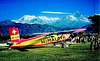
Still, it was out of reach to finance an army of porters. But how should the equipment be carried to the base camp? At that time Switzerland could already look back on a experience of glacier landings with small aircrafts. See the rescue of Americans on the Gauli glacier on the Wetterhorn page (route 2: Gauli). A feasibility studies was made that led to renting a PC-6 aircraft produced by the Pilatus Werke. It would be the first time that a Himalaya expedition would use an aircraft and that it would land and start at an altitude of 5700 m. This world record is still (year 2002) unbeaten and is registered in the Guinness Book.
 |
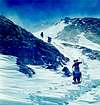
Getting to the Base Camp
The team arrived in Asia by three ways: by airline, by boat with the bulk of cargo and by the Yeti. This tiny plane is of course not the ideal vehicle to travel from one continent to another. Both range (ca. 500 km) and speed (max. 250 km/h) made many landings necessary. Detailed planning was very important to avoid running out of gasoline or getting stuck on a small airstrip because papers were missing. The plane was actually a PC-6 produced by the Pilatus Werke. Of course, no control tower ever heard of this model and in Damascus the tower asked twice for the type of aircraft. The Syrians had prepared the landing with a large passenger ladder and a string of luggage trucks. There was a huge laughter when the tiny Yeti arrived, the tower understood DC-6.
The biggest fear was neither the flight weather nor the navigation, but the bureaucracy in India, Pakistan and Nepal. Due to numerous helpers at the Swiss embassies, the Swiss airline, the many local friends that Eiselin made in 1958 and the excellent knowledge of the local language and habits and the Nepalese government by the team member Jean-Jacques Roussi who worked in Kathmandu as a member of the Swiss Aid Organisation for Nepal. The expected difficulties with the numerous government officials could thus be minimized and no significant delay occurred. Happily all team members arrived in Kathmandu on time.
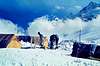
After an initial stay at the Bhairava, Pokhara was chosen as the base airfield, although it had one serious drawback: no petrol available, it had to be flown in from Bhairava. On several reconnaissance flight around the Dhaulagiri only two landing places were be found: one at the foot of the NE spur at 5700 m and a lower one for acclimatization 5200 m on the Dambush pass. Certainly not ideal! A strip at 4000 m would have been much better. The flight from 200 m to 5200 m and from 45° C to a nightly temperature of -20° C within an hour could cause a shock for the mountaineers. Diemberger and Forrer would be the first passengers and would not mind the shock: on the contrary, they opted to fly directly to the base camp at 5700 m. This would reduce the long march over the French pass around the Breithorn and the Tukucha Peak. Due to the still unknown problem of landing in high altitude (the maximum had been at 4200 m) and the well known problems of acclimatization, Eiselin finally decided that the Dambush pass would be the first target.
The transport started March 29th; 2-3 flights full of cargo were flown on an average morning. The afternoon was off due to the typical Dhaulagiri weather with storm and fog.
The landing was no different than in the Swiss Alps and did not pose problems to the experienced glacier pilots. The shortage of oxygen forced the pilots to use the mask and they felt that engine developed less power than in the Alps. But what was really new to them were the extremely strong winds on the plains of Nepal. The expedition doctor gave strict order to relax several days on the Dambush camp, sitting and sleeping to avoid acute mountain sickness.
Forrer and Diemberger started first and built - together with two sherpas - the camp up there. Soon the rest followed. It was hard to keep quiet when you feel fine and some of the members got sick. Victims were Weber and Vaucher who took a tent and lived 500 m below the pass in order to recover.
After one week of acclimatization it was decided to fly to the foot of the NE-spur at 5700 m. Some of the material was already there; Schelbert joined them soon, since it was of interest to find out what influence his vegetarian eating habit would have on the organism. The five mountaineers - including two sherpas - soon started preparing the camps III to VI on the NE-spur (camp II was the base camp). They had no radio contact up there with the rest of the expedition and they were astonished whn the Yeti did not show up anymore. The food transport was not completed, so they lived on very monotonous meals with oat flakes and rice, which made all members vegetarians. When the Yeti reappeared after three weeks, they learnt that its engine had stopped working and a replacement had to be flown in from Switzerland, a logistic miracle in view of the distance and the bureaucratic government officials. Finally the rest of the material in Pokhara and at the Dambush pass could be flown to the base camp. Yet, the new life of Yeti did not last long. On May 5, it crashed after take off on the Dambush pass, after the rubber grip of the control column broke off. Saxer and Wick who were aboard left the plane uninjured. They managed to walk to the Dambush camp, but had a horrible time since they were not used to this altitude without additional oxygen. On the next day they walked down to Tukucha (2650 m). The damaged plane is still there several 100 meters below the Dambush pass.
The absence of this mean of transport seperated the expedition in three parts:
1. The team in Pokhara had to transport the rest of the material to the base camp on foot through the Mayangdi valley under the direction of Skoczylas. They had to build 2 camps on its way, one at 4700 m and 5100 m.
2. The team at the Dambush pass had to carry its matierial to the base camp as well, needing 2 additional camps for this task.
3. The group at the base camp concentrated on the final ascent, which is briefly described in the following chapter.
 |
 |
 |
Friday, 13th May 1960
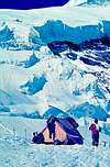
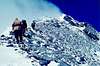
A month before the successful attempt, the small team of 5 mountaineers (Forrer, Diemberger, Schelbert, 2 sherpas) on the
NE-Col started to build the three camps III to V on the spur. They also added some fixed ropes to those left by the Austrian team of the previous year. There was hardly any doubt, that in case of good weather, it should be possible to reach the summit. The difficulties (max. IV) were within the capabilities of the excellent team, there were no avalanches along the spur and there was enough room to place the tents. Inspite of Yeti's problems, there was enough food and material in the base camp for those 5 people.
On May 5th, the weather was bitter cold but clear. The team, completed in the meantime by the members of the Dambush
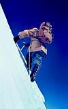
pass, felt that it was time for the final assault. It left camp V (7450 m) and avoided to follow the spur to the main ridge (French ridge, SE- ridge), but kept more to the right where a snow field leads almost directly to the summit. However, the men got lost in the deep powder snow and proceeded very slowly. They decided to turn left to reach the spur and crest a difficult rock barrier. The following couloir was steep and the snow covered almost the whole body. It was noon, the weather typically began to deteriorate. They reached the point were the spur united with the main ridge (7800 m). Visibility was zero and they had to give up. This attempt brought two important conclusions: the summit must be reached by noon, before the weather turns. This asks for a higher camp VI. Moreover, they would not try the snow field anymore but stay on the spur and then stay on the SE-ridge.
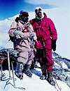
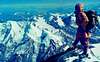
On May 12, six members left camp V (7450 m) and followed the new plan. The weather was fine but the wind was bitter. They had to climb over a rock barrier with heavy packs. At 7800 m the two sherpas hacked a platform under an overhang for a small and lightweight Scheck tent. Everybody suffered with thirst. Four Europeans sat in the tent, while the 2 sherpas were cooking tea at the entrance. The air became moist, everything in the tent was wet of steam. Diemberger wanted the sherpas to make tea all night long, but they refused, took their sleeping bags and spent the night outside. Nobody could sleep. They wanted to start early, but all actions took so long that is was 9 a.m. when the last man left camp VI. Diemberger left first with a sherpa, followed by Forrer and his sherpa. Last were Schelbert and Diener, who joined the team of the East Col only recently and had therefore some problems with the altitude.
The day started bitter cold, with blue sky, and - surprisingly - no wind! The climbers avoided the snow field and strictly stayed on the ridge. Diener's problems became evident when he used to stop every minute and soon the two lost touch with the other teams. As mentioned earlier, they climbed without oxygen mask. Diener and Schlebert decided that each should follow his own rhythm and unroped, although the arrow was very narrow and demanded great concentration. When Schelbert reached the other two teams, Diemberger asked him to go ahead so he could make some shots with his 16 mm movie camera. From then on Schelbert went ahead over the exposed ridge and sometimes wondered if this was the peak or if the next one is slightly higher. He aimed with his ice axe to the next peak to see if it looked up or down. He finally decided that he is on top and drove three pitons into the summit block and fastened a red nylon rope to them. After half an hour his friends appeared and even Diener made it. So there were 6 men on top of Dhaulagiri at noon, happily together, under a blue sky with no wind.
Schelbert seemed to feel bad about unroping Diener and he undertook everything to ensure a safe descent of his weakened friend.
10 days later Weber and Vaucher reached also the summit.
The expedition was lucky, although the airplane had two failures, one sherpa fell into a crevasse, one team erred around all night long on a glacier, etc., but nobody got seriously hurt and everybody reached home safe and sound.
 |
 |
 |
 |
 |
External Links
- Thomas Humar - Dhaulagiri South Face Solo
Ugly Page of a great Mountaineer - Report from the Trekkingtour to Nepal - Dhaulagiri.
Many Pictures about my Trekkingtour to Nepal - around Dhaulagiri 8167m and with Route Description. - Sunset over Annapurna 1
Sunset over the Annapurna Massif from camp 2 on Dhaulagiri1 - The "Eiger" and Dhaulagiri 1 from BC
The climbers' memorial at the Base Camp of Dhaulagiri 1 - Swedish Dhaulagiri expedition
Information in swedish about Dhaulagiri
jck - Jun 21, 2005 4:18 am - Hasn't voted
Untitled CommentNormal route was climbed in 1985 in winter by a Polish expedition led by Adam Bilczwski.Jerzy Kukuczka and Andrzej Czok reached the summit on 21st of January.
In may 1978 Japanese Toshiaki Kobayashi and Tatsuje Shigeno climbed south pillar.Also Japanese: Tsutomu Mizyaki,Hiroyuki Tani and Akira Ube climbed south-east spur in October 1978.
Many new routes were climbed by Czechoslovakian expeditions.Most of them were led by J.Novak.In 1984 they climbed left side of west wall.Four years later the ended the French route on south-west pillar.
In 1980 Wojtek Kurtyka,Ludwig Wilczynski,Rene Ghilini and Alex MacIntyre climbed the incredible,2400 meters high east wall.They were climbing in alpine style.