
|
|
Mountain/Rock |
|---|---|
|
|
36.66005°N / 81.5449°W |
|
|
Grayson, Smyth |
|
|
Hiking |
|
|
Spring, Summer, Fall, Winter |
|
|
5729 ft / 1746 m |
|
|
Overview
Mount Rogers is most notable and most famous as the highest peak in Virginia. The mountain is also the second-most prominent point and second-most isolated peak in Virginia, as well. The peak is also notable as the 19th-highest State Highpoint in the United States and the fourth-highest State Highpoint east of the Mississippi River. The mountain is also the highest eastern State Highpoint which does not have any roads or pavement leading to its summit.
Mount Rogers
In addition to being a State Highpoint, Mount Rogers is also a "two-fer" County Highpoint. In other words, it is the highest point of two counties. Mount Rogers is only one of four such peaks in Virginia as well as only one of 35 such peaks in the entire United States.
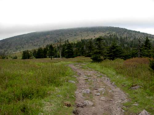
The summit of Mount Rogers is reached via hiking trails. The shortest and most popular hiking routes are via either Massie Gap (in Grayson Highlands) or Elk Garden Trailhead. The south approach from Massie Gap is approximately eight miles roundtrip, and the west approach from Elk Garden is approximately nine miles roundtrip. Another alternate approach is the Mount Rogers Trail, originating from north of the mountain. The approach from Massie Gap is considered by many people to be the most scenic summit approach and is definitely the most popular route option for Mount Rogers.
Due to the region's widespread popularity with visitors even many years ago, Grayson Highlands State Park was created near Mount Rogers in 1965. During the following year, the United States Congress established the Mount Rogers National Recreational Area (NRA) as an additional way to try to protect and preserve the natural landscape of the region. The Mount Rogers summit is the centerpiece of the NRA, and is the highest point Lewis Fork Wilderness as well as the George Washington-Jefferson National Forest. Mount Rogers is the highest point of the New River and Kanawha River drainage basins, too. The nearest higher peak is Grandfather Mountain, over 40 miles away in neighboring North Carolina.
Mount Rogers is the northernmost location to one of only six remaining high-altitude Southern Appalachian spruce-fir forests, and the only such forest in Virginia. The other Southern Appalachian spruce-fir forests are located in the Great Smoky Mountains (near Tennessee/North Carolina border), the Black Mountains (in western North Carolina), the Great Balsam Mountains (in western North Carolina), and on Grandfather Mountain (in western North Carolina) and Roan Mountain (near Tennessee/North Carolina border). Within the spruce-fir forest on Mount Rogers is Fraser fir, a high-altitude evergreen coniferous tree only located in a few areas of the Appalachian Mountains and typically above 5500' elevation. Unfortunately, these firs have been in gradual decline ever since 1962, when the balsam woolly adelgid, an invasive non-native European insect, first started infesting the forests on and near Mount Rogers.
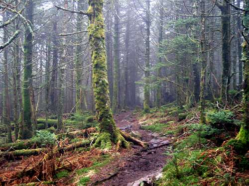
Thick Spruce-Fir Forest Atop Mount Rogers
The thick spruce-fir forest prevents any views from the summit of Mount Rogers. However, the trails which are used to approach the summit sometimes have far-reaching viewpoints, as they pass through open grassy meadows and cross bald ridgetops. Much of the area is also full of rhododendron thickets, which bloom vividly during the months of May and June.
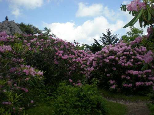
At Rhododendron Gap, near Mount Rogers
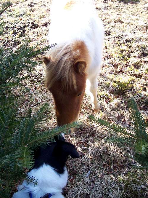
People who approach Mount Rogers from Grayson Highlands State Park (Massie Gap) will likely see another locally popular attraction: wild ponies. Unlike the wild horses found roaming in the western United States, which are mostly of Spanish mustang descent, the wild ponies of Grayson Highlands are of Shetland pony descent and are not actual horses (although they are related). The Grayson Highlands ponies were introduced to the area many years ago to help control the spread of native hawthorn, thorny shrubs and trees found throughout the region. These types of ponies were specifically chosen for their heartiness and ability to live above 4500' elevation.
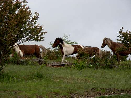
Wild ponies seen running near the Rhododendron Trail
The wild pony population in Grayson Highlands is limited to approximately 120 ponies. The Wilburn Ridge Pony Association, a local citizen group, manages the population. Every September, the group works together with park officials to select & round-up specific ponies for an adoption auction at Grayson Highland Fall Fest, to help control overpopulation from occurring. The ponies are most commonly seen between Massie Gap and Thomas Knob Shelter. Although considered wild, the Grayson Highlands ponies are very comfortable around humans, with some getting close enough for people to touch. However, touching and feeding the ponies is against park policy.
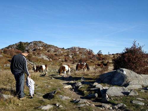
Wild ponies within close proximity, in Grayson Highlands State Park
Mount Rogers was named in honor of Wiliam Barton Rogers, who was Virginia's first-ever State Geologist as well as the founder of the Massachusetts Institute of Technology (MIT). Mount Rogers is geologically notable for having evidence of ancient Precambrian volcanic activity as well as being the only location in Virginia with evidence of ancient Proterozoic glaciation.
Getting There
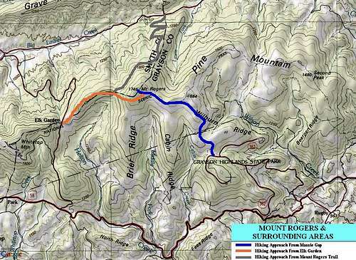
General map showing three most popular approaches to Mount Rogers
DRIVING DIRECTIONS FOR STANDARD APPROACH (via Grayson Highlands / Massie Gap):
1) Follow Interstate 81 until nearing the city of Marion.
2) Take exit 45 at Marion, and then turn south onto State Highway 16.
3) After approximately 24.1 miles, turn right (west) onto U.S. Highway 58.
4) After approximately 7.7 miles, turn right (north) onto State Highway 362.
5) After nearly two miles, arrive at the parking area for Massie Gap in Grayson Highlands State Park.
------------
DRIVING DIRECTIONS FOR ALTERNATE APPROACH (via Elk Garden):
1) Follow Interstate 81 until nearing the town of Chilhowie.
2) Take exit 35 at Chilhowie, and then turn south onto Whitetop Road. The road is also named County Road 600 and County Road 762.
3) Follow Whitetop Road/CR-600 for approximately 16.3 miles, until arriving at the Elk Garden parking area. The trailhead will be on the east side of Whitetop Road/CR-600.
------------
To reach the summit from Massie Gap (elevation 4650') in Grayson Highlands, follow the obvious trail (Rhododendron Trail) north for a half mile to the Appalachian Trail (AT). Turn left and follow the AT up Wilburn Ridge through Rhododendron Gap, and continue beyond the Thomas Knob Shelter to the short spur trail which leads to the Mount Rogers summit. Total distance is approximately four miles one way. This route is the most popular and most recommended summit approach for Mount Rogers.
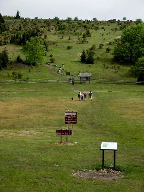
At the beginning of the Rhododendron Trail at Massie Gap
From the Elk Garden Trailhead (elevation 4450'), follow either the AT or the Virginia Highlands Trail north to the spur trail which leads to the Mount Rogers summit. This route is also about four miles one way. This route is not as popular of a summit approach for Mount Rogers, but still has a decent amount of visitors.
Hiking near Elk Garden
Red Tape
Grayson Highlands State Park is a fee-for-use area. As a reference, for many years the park entrance fees for passenger vehicles had been:
Peak season weekend day, per passenger vehicle: $3
Peak season weekday, per passenger vehicle: $2
Memorial Day-Labor Day: $2
It is always advised to verify current fees, rules, and restrictions with the Grayson Highlands State Park headquarters prior to any visit.
The entrance gate and trails within Grayson Highlands State Park are typically only open from 7:00 AM-10:00 PM during Spring, Summer, and Autumn seasons. The entrance gate and trails within Grayson Highlands State Park are typically only open from sunrise to sunset during Winter season. Contact the Grayson Highlands State Park headquarters prior to any visit, to verify current hours, rules, and restrictions.
CONTACT INFORMATION:
Grayson Highlands State Park
829 Grayson Highland Lane
Mouth of Wilson, Va. 24363
TELEPHONE: 276-579-7092
------------
There are currently no fees or time restrictions when approaching Mount Rogers via Elk Garden.
------------
All National Forest trails are open to foot and equestrian travel except the following foot only-trails: Appalachian Trail, Mount Rogers Trail, Mount Rogers Spur Trail, Cliffside Trail, Pine Mountain Trail, and Lewis Fork Spur Trail.
Dogs are allowed but are required to be on a leash in both Grayson Highlands State Park and the Mount Rogers NRA.
When To Climb
Mount Rogers can be summited throughout the year, with peak hiking season occurring from late Spring through Autumn. Only a modest snowpack tends to develop during Winter and early Spring. However, by virtue of being the highest point in a 40+ mile radius, the peak is a virtual beacon for clouds, storms, cold, and wind.
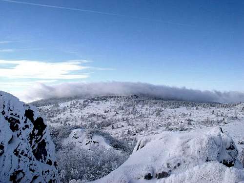
Mount Rogers, as seen from Wilburn Ridge
During peak hiking season, temperatures range between 50-70 degrees Fahrenheit during days and between 30-59 degrees Fahrenheit during nights.
It is always advised to check projected weather conditions with Grayson Highlands State Park headquarters prior to any visit.
Camping
Developed fee-for-use campgrounds are available in Grayson Highlands State Park and at several locations in the National Forest. Thomas Knob Shelter is very inviting, but AT through-hikers should be given "first dibbs" at that location. There are many nice campsites along nearby ridgetops. No fees or permits are needed for backcountry camping in Mount Rogers NRA. State Park camping is only allowed in developed sites. No camping or fires are allowed on the summit.
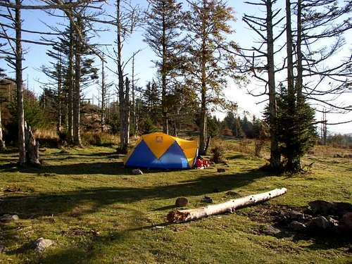
Example of backcountry camping near Wilburn Ridge
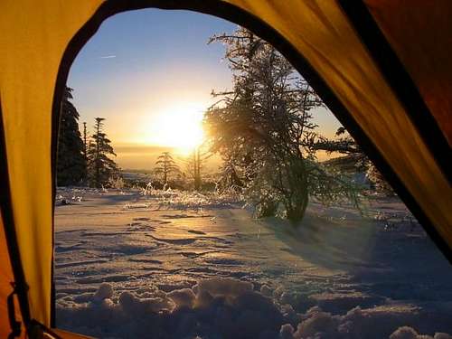
Example of winter camping near Mount Rogers
Established campsites near and along the Mount Rogers Trail, originating north of Mount Rogers:
- Near Mount Rogers Trailhead: Grindstone Campground, located along Virginia Highway 603 (1/4-mile west of trailhead). Fee camping.
- 2 miles From Trailhead: Lewis Fork campsite, located at intersection of the Mount Rogers Trail and Lewis Fork Spur Trail. Free.
- 3.5 miles From Trailhead: Campsite at 4900' elevation along the Mount Rogers Trail, located before Deep Gap (free)
- 6 miles From Trailhead: Thomas Knob Shelter, located along the Appalachian Trail and near the Mount Rogers Trail. This campsite is free but campsite priority is given to Appalachian Trail through-hikers.
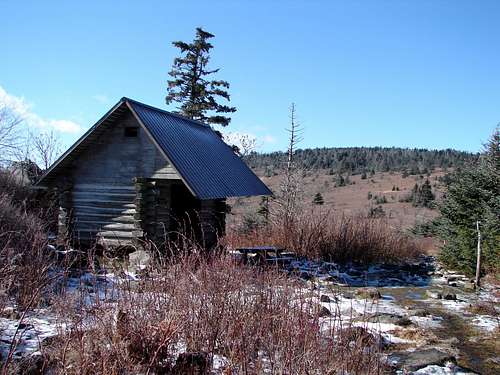
Thomas Knob Shelter
Mountain Conditions
CONTACT INFORMATION:
Mount Rogers National Recreation Area
3714 Highway 16
Marion, VA 24354-4097
TELEPHONE: 276-783-5196, 800-628-7202
Office hours are typically from 8:00 AM - 4:30 PM, Monday through Friday. From mid-May until mid-October, the Visitor Center is also typically open each Saturday from 9:00 AM - 5:00 PM.
------------
Grayson Highlands State Park
829 Grayson Highland Lane
Mouth of Wilson, Va. 24363
TELEPHONE: 276-579-7092
Visitor Center hours are typically from 10:00 AM - 6:00 PM, daily, from Memorial Day through Labor Day.
Mount Rogers Weather Links
Maps and Other Links
Aerial View of Mount Rogers
USFS Mount Rogers Web Site
Grayson Highlands State Park Site
State Park Brochure and Map (PDF)
climber404 - Feb 12, 2003 4:04 am - Hasn't voted
Untitled Commenthttp://www.southernregion.fs.fed.us/gwj/mr/campgrounds.htm. This is the Federal Governments webpage for the Mount Rogers NRA.
the_pretzel2 - Nov 20, 2018 10:49 pm - Hasn't voted
Re: Untitled CommentThat URL gives an error saying that IP address can't be found.
e-doc - Jan 28, 2006 7:12 pm - Hasn't voted
Untitled CommentAccess from VA 603 at Grindstone CG. Climb the Mt Rogers trail to Deep Gap, AT north to spur then summit. . Other trails from 603 include Lewis Fork, Cliffside or AT to the Pine Mt trail. On the Pine Mt trail go south to Rhododendron Gap, take the AT south to the spur and up to summit
gwave47 - Aug 2, 2006 12:30 am - Voted 10/10
Summit MarkerGreat page. Excellent Job! Just wanted to add that I hiked Mt. Rogers this past weekend and when we got to the top we kept looking for the next part of the trail. We figured we weren't there yet since we hadn't seen the summit sign. We looked around for 20 -30 minutes and took some dead end routes before a group came up and told us we were at the summit. This is why I wanted to add for others wishing to hike this mountain for the first time that there is no sign marking the summit/highpoint. When you reach the summit there will be a boulder rock and if you look closely you will see a medallion mounted in/on the rock. This is the summit.
Alpinist - May 19, 2011 10:44 am - Voted 10/10
Camping BetaCamping beta along the Mount Rogers Trail: