
-
 18578 Hits
-
 79.37% Score
-
 11 Votes
|
|
Mountain/Rock |
|---|---|
|
|
35.36330°N / 111.6142°W |
|
|
Coconino |
|
|
9283 ft / 2829 m |
|
|
Overview
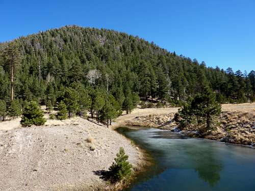
This mountain is a round, dull looking Lava dome on the northern part of the San Francisco Peaks and Locket Meadow. Nothing stands out about the mountain itself, but the views from the top of the mountain are extraordinary.
Since it sits at the end of Locket Meadow, you look right into to Inner Basin and see all the mountains that make up the San Francisco Peaks. The mountain sits in a very popular area but there is no trail to the top and the hike is very steep, so it is seldom hiked. The crowds hit the trail that leads into the Inner Basin.
The hike itself is about 750 feet to the top, but it is very steep. The mountain abruptly rises out of the northern end of Locket Meadow.
There is no standard route. The mountain is almost perfectly round and is equally steep on all sides. You can hike it from any direction. You also can follow the road up to a saddle on the other side and hike it from there. The saddle is at 8692 feet. There are no climber trails.

Getting There
From US 89 Heading north of Flagstaff turn left on a dirt road directly across from the Sunset Crater Rd. There is a sign that tells you which direction Locket Meadow is. Follow the signs and you can't go wrong. Once in Locket Meadow Park near the entrance. Sugarloaf is the first mountain you come to and is dwarfed compared to all the rest of the mountains.
Red Tape
Locket Meadow Road is closed in the winter. Getting in can only be done on skis or snowshoes. No Parking Passes are required. Locket Meadow is also very crowded on weekends in the summer.
When To Climb
May-Sept or Oct.
Camping
Locket Meadow is a very popular place to camp. Camp Fires vary every year. If it is Dry then it may be illegal to have campfires. Check with the Forest Service.
Geology
After San Francisco Mountain blew its top, Sugarloaf started to form just on the entrance to the Inner Basin. The surface of Sugarloaf is so heavily forested that clues to the inner structure are very difficult to recognize. The dome reflects the shape of the one formed at Mout Saint Helens in Washington and was formed in the same way. Sugarloaf is an exogenous type of lava dome. There was a pumice mine at the base of Sugarloaf. The pumice was laid down before Sugarloaf was formed.
callthedoctor - Oct 31, 2002 8:12 pm - Voted 10/10
Untitled CommentHard to tell where the exact "summit" is....
There is a large outcropping of crumbly basalt on the south-eastern part of the top of the dome....I would consider this the tippy-top.
This short 20 foot scramble yielded absolutely gorgeous views, west, into the inner basin...most likely the best IB views one could find since you could see all of the peaks and summits at once.....as well as San Francisco caldera in its glory.
callthedoctor - Oct 31, 2002 8:20 pm - Voted 10/10
Untitled Commentare the best time as it is VERY crowded on Sat. and Sun.
cjmall - Sep 3, 2023 7:31 am - Hasn't voted
Lockett Meadow Rd and Campground are ClosedWanted to note in case anyone comes across this who is not from the area...the road to Lockett Meadow has been closed for some time due to the fire and flooding that destroyed the road. As of now to my knowledge, there is no date for reopening. You can still get to Lockett Meadow; but you have to hike up the road, so keep that in mind if you go.