


|
|
Mountain/Rock |
|---|---|
|
|
19.82060°N / 155.46809°W |
|
|
13796 ft / 4205 m |
|
|
Acknowledgment
Thanks to "kironic" for writing much of the original page text, especially the more entertaining parts!
Overview
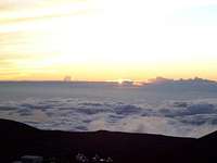
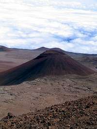
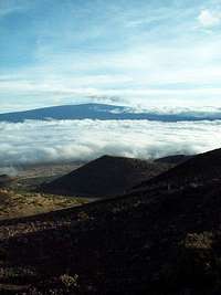
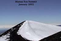
Mauna Kea, on the Big Island, is Hawai'i's highest mountain at 13796 ft (4198 m). Rather than a single peak, Mauna Kea is undefined; it is a series of volcanic cinder cones, some red, some black, pasted onto a gargantuan massif. While it is tempting to draw grand analogies about how Mauna Kea embodies the spirit of Hawai'i itself, the real king mountain of the Big Island is Mauna Loa, which regularly spreads lava flows over a radius of 50 miles in almost every direction. However, because Mauna Kea's slopes are steeper than Mauna Loa's, the former's summit views are better, and its hikes shorter.
The maintained Mauna Kea Trail is 6 miles in length (one way) and climbs 4576 ft (1395 m), starting from the Onizuka Visitor Center, which is at 9200 ft (2804 m). The trail loosely parallels a partially paved summit road, and from the Mauna Kea Ice Age Reserve boundary at 13200 feet to the summit road's high point of 13700 feet, actually follows the road. Getting to the summit from road's end requires a mere 5-15 minute walk and 100 feet of elevation gan. The vast majority of "mountaineers" drive to road's end, which can be kind of discouraging for hikers, especially when the altitude starts kicking in. Aside from the moral superiority you can enjoy from hiking, you'll take in splendid and wild views along the way. (NB: Hitchhiking is not unheard of.)
An interesting side trip is the short jaunt to Lake Waiau, a very shallow lake (no more than 10 ft deep) about a mile and a half from the summit. You aren't supposed to disturb the lake, and you probably wouldn't want to since Hawaiians used to bring the umbilical cords of their babies here and place them in the lake to give them "the strength of the mountain". If you must drink from the lake, however, today's modern filtration systems should take care of any lingering placental matter.
 |
 |
 |
 |
Getting There
By car: From either Hilo or the Kona/Waimea area, access the Onizuka Visitor Center via Saddle Road (Highway 200). The Visitor Center is 6 miles upslope on Summit Road, the turnoff to which is near the 28-mile marker off of Saddle Road. Warning! As of March, 2003, there are no signs marking the turn to summit road. Apparently, the signs keep getting stolen. The ranger speculates that it's astronomy students from UH-Hilo, but it's anyone's guess. In any case, the road is prominent, and in the author's recollection, there are no others in the area to confuse with.
Current road conditions - (808)935-6268 (July, 2020)
Previously, most car rental contracts prohibited travel on Saddle Road, although in April, 2015, asaking11 noted: "Most rental companies now allow rental cars on Saddle Road. There are even a handful of them that will allow you to take them to the visitor center." A car is definitely the best way to get there. Not by car: The problem is the buses don't use Saddle Road. So, use a car by proxy. (Hitchhike). But seriously, don't worry about the car rental agencies? policy. They don't dust the tires for Mauna Kea dust or anything.
In June, 2021, Pete Grafton noted: "Calling the summit road conditions number, the recorded ranger message warns us a 4x4 is required to drive past the ranger station at 9,200 feet. If not driving the hike is around 11 miles RT with water at the lake. Flatlanders like me need the 4x4."
The trailhead for the Mauna Kea Trail is a hundred yards northwest of Onizuka Visitor Center.
 |
 |
 |
 |
 |
Red Tape
No permits or fees. Rangers do ask that you fill out a Visitor Information Sheet and drop it in a box next to the phone at the Visitor Center, but they will only use this information in case of an emergency. If you want to be really concientious, you can even print out a copy of this form before hand! http://www.ifa.hawaii.edu/info/vis/
Note that Mauna Kea is not in the Hawaii Volcanoes National Park. You would be thinking of Mauna Loa, the second tallest peak in Hawaii. Mauna Kea is leased to the University of Hawaii from the 12,000-foot level and up. So they generally take a not-for-profit approach. Hallujah.
If you'd like to part with your money, you can use professional guides http://maunakea.com. This would also solve the "how to get there" problem, if you don't have a car, since these guides will pick you up from centrally located STARBUCKS (TM) in three different places on the Big Island, which can be reached by bus.
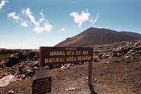
Wildlife conservation: Outside the Mauna Kea Ice Age Natural Reserve, hunting is allowed and common. Also, it is interesting to note that there was a very heartfelt and effective campaign to remove mouflon game sheep from Mauna Kea.
When To Climb
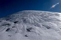
Generally avoid January and February, as winter storms can drop up to 2 feet of snow. However, snow flurries are a definite possibility year round, so be prepared for this peak as you would any almost -Fourteen-er.
 |
 |
 |
 |
Camping
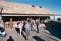
No camping in the area. Acclimatizing is very important since you will more than likely be driving up to the mountain from sea level, or, even below sea-level if you have spending your sun-drenched days scuba-diving. So consider camping at the Mauna Kea State Recreation Area, 7 miles west of Summit Road (the road that goes to Mauna Kea), at about the 35-mile marker on Saddle Road. Try to go during the week, as hunters (of pigs, goats and birds) both local and of the tourist variety usually have dibs on the weekends. If you can't camp, hang out at the Onizuka Visitor Center before making the trek up. You can learn everything you wanted to know, and more, about the different observatories on the summit.
Website: Mauna Kea Cabins
Mountain Conditions
Mauna Kea weather: http://hokukea.soest.hawaii.edu/
Current road conditions to the summit: call (808) 935-6268 (July, 2020)
Visitor Center Hours: (808) 961-2180 website:http://www.ifa.hawaii.edu/info/vis/
Keep in mind there is no food or gas available on Mauna Kea.
 |
Geology and Glaciology
Hikers may note with some incredulity that the Mauna Kea Trail passes through the Mauna Kea Ice Age Natural Area reserve. Glaciologists believe that, at some point in recent geologic history, there was a glacier of some size on this mountain. Hardly surprising, since at its peak 500,000 years ago, Mauna Kea was thought to stand 17,000 feet above sea level. Unfortunately, the author of this page could detect no obvious glacial remnants (rock scouring, rock moraines, glacial cirques, etc.)
Much of the "proof" of glaciers seems to center around the presence of native adze quarries. The natives set up summer residences in excavated caves and spent the months mining a rare, extremely hard volcanic rock that geologists believe could only have been formed by lava intruded under an existing snow or ice field. The rock was prized throughout the Hawaiian islands for use in a variety of stone implements. Beware of carrying off a souvenir, however. Aside from the fact that this is illegal, we can learn from Greg Brady and Scooby Doo, among others, that taking such souvenirs from Hawaii leads to bad luck and zany adventures.
Still, the line between semi-permanent snow field and true glacier is thin. It is possible, even probable, that Mauna Kea had glaciers on its slopes in the late Pliestocene or even in the more recent global cold spells (8000 years ago, for instance). However, given the high frequency of volcanic eruptive events, most, if not all surface expression of glaciers from 8000 years ago will be fully covered by lava today. In any event, the gullies on the mountain's south face are thought to have resulted from snowmelt from glaciers/semi-permanent snowfields.
Lake Waiau, at 13200 feet, was exploited as a source of drinking water by the native Hawaiians at the adze quarries. The shallow lake, which sits in a small crater on the Pu'u Waiau cinder cone, is curiously thought to be fed by melting permafrost. Still, one cannot ignore the possibility of some spring feeding, as the highly porous/permeable volcanic rock produces many other marked springs.
Lava Lovers: Mauna Kea is a dormant volcano. In technical terms, Mauna Kea is a classic shield volcano. They say that it could erupt in the foreseeable future (geologically speaking).
 |
 |
 |
 |
Skiing
Interesting side note: Mauna Kea can be skied. There are no lifts or resorts, but when the snow falls on Mauna Kea, usually in January and February and continuing for several months, you can earn your turns and board or ski it. Don?t take your best gear, though, as you will encounter uneven snow coverage over those tough lava rocks. Wouldn't it be worth it, if simply for the novelty of being able to say you skied during your vacation to Hawaii? If you?d rather just go down than have to go up, the people to contact are Ski Guides Hawaii (808) 885-4188, PO Box 1954, Kamuela, HI 96743 (website: http://skihawaii.com/ ). They will provide equipment, transportation to the mountain from their office in Waimea, and once on the mountain, a ride up the mountain after each run.
Trivia
It may also be of interest to readers that according to the Guinness Book of World Record's, Mauna Kea is the world's highest mountain (33,476 ft or 10,203 m) when measured from the ocean floor. Why climb Everest when you can....?
As most people know, Mauna Kea's summit region is home to a great many large telescopes and other space observation instruments. While there are higher mountains and mountains with dryer weather, the atmosphere above Mauna Kea is world-renowned for its lack of atmospheric "wind shear", which causes distortion in visible images.
Panoramic Photos
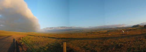 Mauna Kea from Highway 190 near Waimea (Morgan Brown) |
 Mauna Loa from lower section of Mauna Kea Trail (Morgan Brown) |
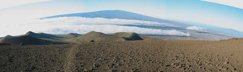
360° panorama from Mauna Kea's true summit (Morgan Brown) |
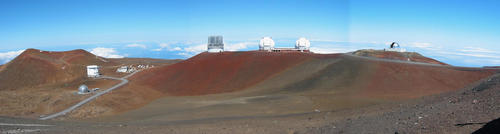 Mauna Kea's telescopes from highpoint of Summit Road (Morgan Brown) |
External Links
- Guide to Visiting Mauna Kea observatory
by University of Hawaii - Arnot's lodge and Hiking adventures
Private outfitter - some good pictures. - Webcams
Mauna Kea Observatory website, featuring various webcams on the summit of Mauna Kea
asaking11 - Apr 29, 2015 6:30 pm - Voted 8/10
Rental companiesMost rental companies now allow rental cars on Saddle Road. There are even a handful of them that will allow you to take them to the visitor center.
mpbro - Apr 29, 2015 8:25 pm - Hasn't voted
Re: Rental companiesThanks for the info. I added your info to the page, and also made you admin if you want to make any other changes. Thanks!
Scott - Jun 9, 2016 1:42 am - Voted 10/10
PanoramicsIt appears that all of the panoramics have been deleted and show up as X's on the page.
mpbro - Jun 9, 2016 9:29 am - Hasn't voted
Re: Panoramicsthanks for the heads up. working now.
Colin - Dec 13, 2017 4:22 pm - Hasn't voted
TrailheadThe visitors center map is misleading. It suggests the trailhead is directly across the road. There's a trail there, but it doesn't lead to the top. Instead, turn right out of the parking lot and head up the road. In a few hundred yards, you'll see a dirt road on your left. Following this road will quickly lead you to the real trailhead. Never did figure out what happens to the trail at the top. It reconnected with the road near the first observatory, but we couldn't see where it went from there. We walked the road up the last half mile or so.
mpbro - Dec 13, 2017 4:32 pm - Hasn't voted
Re: TrailheadThanks! I'm making you an admin for the page. Would you mind changing the page where you think it should be changed? If you don't want to, I can make the change.
Alpinist - Dec 17, 2017 10:26 am - Voted 10/10
Re: TrailheadBetter yet, why not create a Trailhead page with those details? That's what its designed for...
mpbro - Dec 17, 2017 11:14 am - Hasn't voted
Re: TrailheadYou only had "edit" privileges, which I upgraded to "Admin" privileges.
6sniders - Jun 19, 2019 2:25 pm - Hasn't voted
Host or admin for this Summit ?Someone in Hawaii should have this Summit to manage. So many changes to the data and descriptions etc have changed. Saddle road is the best road on the island now,can go 70+ mph if no traffic. Pics of trailhead should be on here and mapped. There is also a sign at the top of the road before the last half-mile.... asking us not to hike out of "respect" because it is considered culturally, historical, and environmentally significant !!!
mpbro - Jun 19, 2019 3:17 pm - Hasn't voted
Re: Host or admin for this Summit ?Agreed. I just granted you admin privileges. Feel free to make any changes!
klimbien - Jul 9, 2020 7:15 pm - Hasn't voted
updated phone number for road conditionsCurrent road conditions - call (808)935-6268 (7/9/2020)
mpbro - Jul 9, 2020 8:33 pm - Hasn't voted
Re: updated phone number for road conditionsthanks, I modified the main page
Peter.grafton - Jun 11, 2021 9:55 am - Hasn't voted
4 wheel drive required to drive summit roadCalling the summit road conditions number, the recorded ranger message warns us a 4x4 is required to drive past the ranger station at 9,200'. If not driving the hike is around 11 miles RT with water at the lake. Flatlanders like me need the 4x4.
mpbro - Jun 11, 2021 9:59 am - Hasn't voted
Re: 4 wheel drive required to drive summit roadThanks, Pete. I added your comment to the "Getting There" section.
drichesin - Dec 17, 2022 10:33 pm - Hasn't voted
Ranger was surly and rudeI visited Mauna Kea in October, 2022 and was met at the top by a very rude and surly Ranger from the summit 'operator' which I believe is Univ of Hawaii. There were several people that had made it to the top in 4X4 vehicles and he stopped everyone and harangued them about being 'disrespectful' to ancient native inhabitants by 'desecrating' the summit area. I was shocked and saddened by this persons strong attempt to dissuade us from summiting. Someone should get a grip on the site's treatment of highpointers and others that just want to enjoy the beauty and wonder of this high peak.