
-
 62239 Hits
-
 90.92% Score
-
 34 Votes
|
|
Mountain/Rock |
|---|---|
|
|
46.51211°N / 121.45424°W |
|
|
Download GPX » View Route on Map |
|
|
Lewis/Yakima |
|
|
Hiking |
|
|
Spring, Summer, Fall |
|
|
7900 ft / 2408 m |
|
|
Overview
 A Hiker on the summit of Old Snowy (view full size)
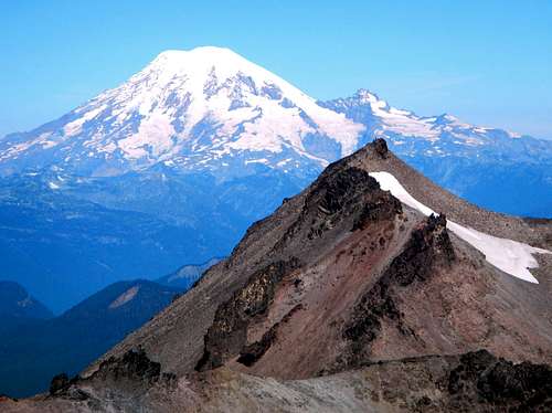
At ~7900 feet Old Snowy Mountain is the fifth highest peak in the Goat Rocks Wilderness. It's centrally located on the spine of the Goat Rocks which runs northwest to southeast. Old Snowy is likely the most commonly visited summit in the whole wilderness group. There is a spur trail (signed as of 2013) which departs from the highest point of the Pacific Crest trail and goes all the way to the summit. Nothing technical is required to make the ascent but some folks might find the last part slightly unnerving because it is loose and slightly exposed. On a clear day, summit views include the three volcanoes, Mount Rainier, Mount Adams, and Mount Saint Helens as well as several other Goat Rocks summits, Hawkeye Peak above Goat Lake, Johnson Peak, nearby Ives Peak, Big Horn, and Gilbert Peak.
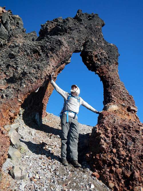 Volcanic Arch
For those with navigation experience and route finding skill, it is highly recommended to make the ridge traverse over to Ives Peak. This is one of the great high alpine traverses in Washington State and it's sure to impress. Not far from the summit of Old Snowy there is a naturally formed rock arch which stands roughly 20 feet high. This is an incredibly rare formation and it's worth the side trip even if you don't intend to make the full traverse to Ives. The majority of the traverse is class 2 but a few class three sections might be encountered depending on conditions. Near the end of the traverse you will come to the McCall Glacier. Some people pass this section by staying inside the moat, while others walk on top of the glacier. It's possible to avoid this section by dropping down onto the southwest slope below the ridge crest.
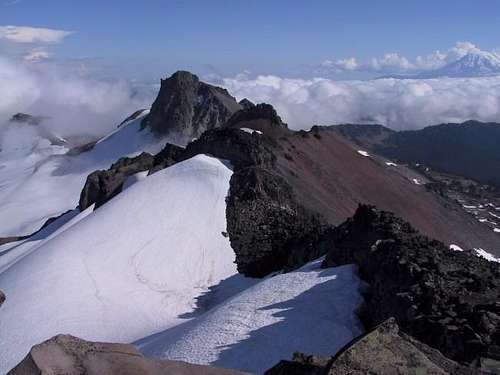
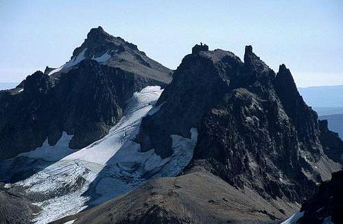 Gilbert, Goat Citadel, Big Horn, seen from the summit
As with all areas in Washington which are volcanic in origin, loose rock is the name of the game. Whether you are just hiking along the spur trail to the summit or you intend to make the traverse over to Ives, don't trust the rock. Talus that looks settled might not be and any handholds you pull on have the potential to pull out. A little caution goes a long way.
Standard Route
With the network of trails in the Goat Rocks, there are several possible ways to access the Old Snowy summit trail. Only the most direct route will be described here. 14 miles round-trip with roughly 3600 feet of gain.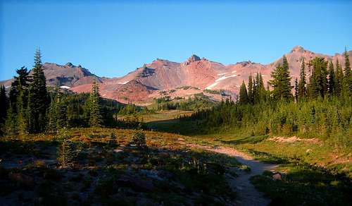 Entering Snowgrass Flats
Starting from the Snowgrass Flats trailhead, hike the trail to a junction in under a tenth of a mile. Do not turn left. This it the Berry Patch trailhead connector trail. Continue along the trail for 2 miles as it goes northeast and gains 400 feet only to lose it again before crossing the Goat Creek bridge.
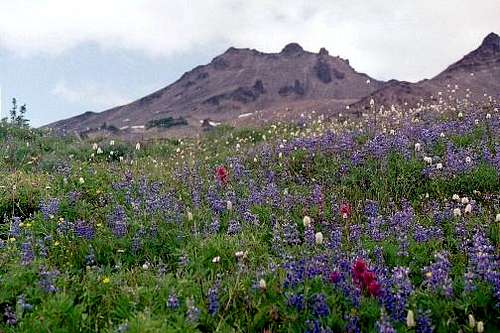 Wildflowers below Old Snowy
Beyond Goat Creek the trail turns toward the east and begins ascending north along a ridge. At 5600 feet there is a trail junction in a flat area with a few camp spots. Do not turn right. Rather continue along the main trail as it ascends the minor ridge. At the next junction located at 6140 feet, turn right and continue for another half mile to a T junction with the PCT.
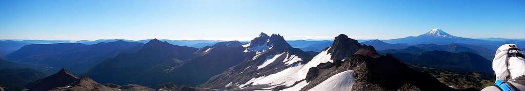
 Ives Peak and connecting ridge seen from the summit
Turn left onto the Pacific Crest trail and follow it north to 7190 feet where the last junction is located. There should be a sign for the Old Snowy Mountain spur trail. At this point, with good visibility the mountain has already apparent for some time. Follow the trail east and then southeast towards the summit. Exercise caution at the end on steep loose rocks.
Route Map
Driving Directions
Directions to Snowgrass Flats trailhead from the greater Seattle area:Take the 405 freeway to Exit 2A onto 167 south toward Kent/Auburn
after 20.4 miles, exit onto WA-512 / WA-161 south toward Puyallup Olympia
after 3.4 miles take the exit onto WA-161 toward Eatonville (left onto 31st Ave)
after 22.6 miles on WA-161 come to Eatonville and turn left at the main intersection (Street E)
after 7.1 miles on Alder cutoff/Street E, turn left onto WA-7 S
after 4.9 miles pass a lake and turn right onto WA-7 S
after 16.8 miles turn left onto US-12 E
after 30.6 miles turn right onto FR-21
after 1.1 miles take the first right onto FR-21
after 6.3 miles right at a fork to stay on FR-21
after 5.7 miles left at a fork onto FR-2150
after 1 mile left at a fork to stay on FR-2150
after 2 miles keep right at a fork and come to another fork, keep to the right on this one-way loop until you see the Snowgrass Flats trailhead
 Summit View to the southeast
 Summit View to the West
When To Climb
This area averages 25-40 feet of snow each winter, and may take until mid-July to melt out completely. Keep in mind that the area is popular in the summer and it can get crowded on the weekends. Winter access would at least require chains and 4x4, but could make for a decent ski/snowshoe route. Call for current conditions.Red Tape / Camping
A Northwest Forest Pass is no longer required to park at the Snowgrass Flats trailhead but it is required for the Berry Patch trailhead. Day use is now monitored. Self-register permits for overnight trips and day use are free at the trailhead. Make sure each group has one permit.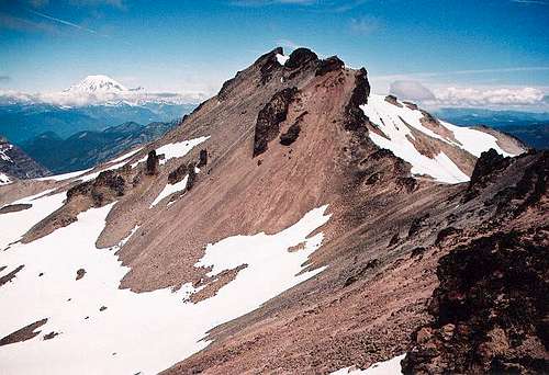 Old Snowy Mountain from the south
Use established campsites above treeline to avoid compromising fragile alpine vegetation. This area is known for blooming wildflower meadows in summer. There are spotty sites and a larger alpine camp near the PCT. There is additional no-fee camping permitted at Chambers Lake Campground near the Berry Patch trailhead, complete with compost latrine.
Miscellaneous
This is a great hike/scramble to initiate interest in beginners. For someone who isn't a world class athlete, the vistas you get for a minimal physical cost will make you feel like a "real" mountaineer. Of course that doesn't mean you should undertake this easy climb if you are completely out of shape.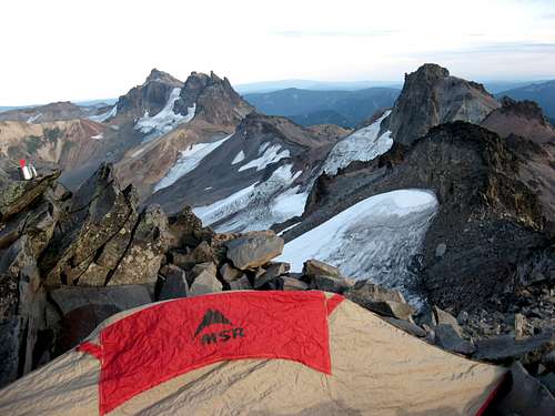
There is a good bivy spot right next to the summit which is big enough to fit a smaller two man tent. It is flat and has rock walls built up to keep out the wind.
The Cowlitz Valley Ranger District (360-497-1100) is located at 10024 Highway 12, P.O. Box 670, Randle, WA 98377-9105
The Packwood Ranger District (360-494-5515) is located on Highway 12, Packwood, WA 98361
See also:
Hiking Washington’s Goat Rocks’ Country by Fred Barnstad
100 Hikes in Washington's South Cascades and Olympics by Ira Spring and Harvey Manning
External Trip Reports
- my September 2013 trip report including our traverse to Ives Peak
- July 2012 trip report by Mike H. about his traverse from Gilbert to Old Snowy
- September 2011 trip report by Jess B about the travere from Old Snowy to Ives
- September 2010 trip report by Bloated Chipmunk
- September 2010 trip report by Romann
- July 2010 trip report by Matt H
- July 2009 trip report by Yet
- July 2009 trip report by DerWanderer
Honkeydong - Feb 22, 2002 12:58 pm - Hasn't voted
Untitled CommentDriving to the trailhead, these Forest Service roads are developing serious washboard effect. Coupled with the St. Helens ash, expect *everything* to be saturated in summer with a fine dust. Wrap your pack in plastic if it's in the bed of a pick-up or in the trunk of a car.
Dunk - Sep 18, 2003 2:27 pm - Hasn't voted
Untitled CommentWe ran into a ranger requesting our wilderness permits (day hike from base camp). He said all users, day or overnight, required permits. As our group had split into two, with some members hiking to Cispus Basin, we didn't have the permit. He let it slide as he was out of his jurisdiction. (from adjoining National Forest)