
-
 78164 Hits
-
 84.66% Score
-
 19 Votes
|
|
Mountain/Rock |
|---|---|
|
|
44.30400°N / 71.318°W |
|
|
5712 ft / 1741 m |
|
|
Overview
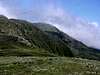
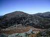
Mount Jefferson is the third highest peak in New Hampshire, after its two bigger neighbors, Mount Washington to the south and Mount Adams to the northeast. Like them, it rises almost 1,000 feet above treeline, with spectacular views. It is more easily accessible (in summer) than Mount Adams, so is likely to be more crowded.
Easier Routes
The easiest route is the Caps Ridge Trail, that starts from Jefferson Notch at an elevation of 3,008 feet (the highest trailhead in the White Mountains), which at 2.5 miles (one way) and with only 2,700 feet of elevation gain is the easiest route to any major peak in the Presidentials. It is steep, rough, involves scrambles over ledges, and has what some may consider an uncomfortable degree of exposure (a very individual assessment). In spite of that, it is definitely the easiest route for those comfortable with moderate exposure.
All other approaches are longer, with substantially more elevation gain. Probably the easiest way is to go up the Jewell Trail, from the Base Station, to the Gulfside Trail to Jefferson (5.5 miles one way, with 3,750 feet of elevation gain). It is nowhere very steep or rough, but is exposed to the weather for a long time.
From US 2 to the North the most common approaches are by the Castle Trail directly to the summit (5 miles and 4,200 feet one way), or by Lowe's and Randolph Paths and the Gulfside Trail (5.5 miles and 4,350 feet one way). Both involve some steep sections, and the Castle Trail involves some scrambles on the Castles.
Harder Routes
A good loop can be made by going up the Castle Ravine Trail (5 miles and 4,200 feet one way) and returning by the Castle Trail. The final climb out of the floor of the ravine up the headwall is a very steep scramble on very loose rock. Descent by the Castle Ravine trail is not recommended. The lower end of the Castle Ravine Trail is largely *in* the stream, and should therefore be avoided in winter or spring. See photos #42 - #44 and #51, #52 here: Jefferson.
Another more difficult approach is from the Great Gulf by the Six Husbands Trail. Take the Great Gulf Trail to the Six Husbands Trail, which ascend the very steep Jefferson's Knee, with scrambles and two pairs of ladders (7 miles and 4,300 feet one way). It is not recommended for descent, the most common way to do a loop is to return to the Great Gulf Trail by following the Gulfside Trail south to the Sphinx Trail which descends to the Great Gulf. This is a long day, many people camp in the Great Gulf to split the trip over two or even three days. An alternative is to spot a car at the Caps Ridge trailhead in Jefferson Notch, this makes a one day trip quite doable.
One Day Presidential Traverse
See description on the Mount Adams page.
 |
 |
 |
 |
 |
Getting There
Two of the trailheads are on US 2 west of Gorham. Lowe's Store is on the north side of the road about 7.5 miles from the junction of NH 16, while the Castle trail trailhead is on the south side of the road 9 miles from the NH 16 junction, and 4.2 miles east of the junction of NH 2 and NH 115. The Castle Ravine Trail is reached from the same trailhead by following the Castle and Israel Ridge trails.
The Jewell Trail trailhead is located on the Cog Railway Base Road about 1.1 miles from the four way crossing with the Mt. Clinton and Jefferson Notch roads.
The Caps Ridge trailhead is near the hight of land on Jefferson Notch Road. From the south that road starts at a four way intersection directly opposite the Mt. Clinton Road, both going off the Base Road which goes to the Cog Railroad. The north end is on Valley Road in Jefferson, which runs between US 2 and NH 115.
 |
 |
 |
 |
 |
Red Tape
For the Castle Trail, Jewell Trail and Caps Ridge trailheads a White Mountain National Forest parking pass is required.
For parking at Lowe's Store a $2 per day fee is charged.
 |
 |
 |
 |
When To Climb
The normal hiking season in the White Mountains extends roughly from Memorial Day to Columbus Day. Winter conditions in the presidentials are harsh, and many would say that Mount Jefferson is the hardest of them all to ascend in winter. The Jefferson Notch Road is unplowed, so easy access by Caps Ridge is impossible. The two commonly used routes, Lowe's and Randolph paths to Edmunds Col and the Castle Trail all the way, are very exposed to the weather.
Camping
The Randolph Mountain Club (RMC) has four shelters in the area:Log Cabin, Gray Knob Cabin, The Perch and Crag Camp (see map for their locations). Fees are charged at all of them (follow the link for each shelter), and no reservations are accepted. All four RMC facilities can be used for overnight trips to Adams and either Madison or Jefferson.
The WMNF maintains a group of primitive (no platforms, no outhouse) camping areas along the Great Gulf trail and some of the trails that branch off it. They are shown in the new AMC map and in the RMC map. There are two sites on the Wamsutta Trail just after it leaves the Great Gulf Trail, and one on the Six Husbands Trail just before the Buttress Trail branches off it. These sites are very useful for those attempting Jefferson by the Six Husbands or Sphinx trails. There are no fees, and reservations are not accepted.
For more information on these facilities, and for ideas on overnight trips, check the Mts. Adams and Jefferson page of my Peakbagging 4000 footers in New England web site.
Mountain Conditions
See the Mount Adams page.
Maps and Other Books
See the Mount Adams page.
External Links
- White Mountain Info Server
Great site with lots of photos and trip reports. - Bagging the New England 4000 Footer Peaks
Describes the most commonly used approaches to all 48 of the NH 4,000 footers, with information on distances and elevation gains.
hgrapid - Jun 18, 2015 1:28 pm - Voted 9/10
Profile Photo?Shouldn't there be a profile photo for Mount Jefferson? Looks like the one on this page was deleted.
hgrapid - Jun 18, 2015 1:29 pm - Voted 9/10
Page not being maintainedThis page has not been updated in 10 years! The owner of the page hasn't been active in 9 years! Please somebody adopt this page!
Bark Eater - Jun 22, 2015 3:13 pm - Hasn't voted
Re: Page not being maintainedDone! Updated the primary image. I'll work on a few other improvements in the near future! If anyone has updates please post them here and I will incorporate into the page. Thanks.
Bark Eater - Jun 23, 2015 11:46 am - Hasn't voted
Re: Page not being maintainedFixed some broken or outdated links. Updated some information. Hope this helps.
nartreb - Jun 23, 2015 6:40 pm - Hasn't voted
castle ravine trailMight be worth mentioning that the lower end of the trail is largely *in* the stream, and should therefore be avoided in winter or spring. See photos #42 - #44 and #51, #52 here: Jefferson
Bark Eater - Jun 24, 2015 7:21 am - Hasn't voted
Re: castle ravine trailThanks. Added the caution.