
|
|
Mountain/Rock |
|---|---|
|
|
44.54400°N / 72.815°W |
|
|
Chittenden |
|
|
Hiking, Scrambling |
|
|
Spring, Summer, Fall, Winter |
|
|
4393 ft / 1339 m |
|
|
Overview
Taken from the approach to the chin. Long Trail, November 5, 06

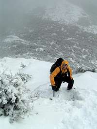
Seth Making his way up the Hell Brook Trail. Nov. 5, 06.
Mount Mansfield is the highest mountain in Vermont; being the highest in the state it is also the highpoint of Chittenden County. The mountain gets its name because when viewed from the east its summit ridge resembles the profile of a human face, and the names of its prominent features reflect this: Adams Apple (4,060'), Chin (4,393', highest point), Nose (4,062') and Forehead (3,940'). For about 2.3 miles (from the Adams Apple to the Forehead) the Long Trail is almost constantly above treeline, the only such long stretch of alpine zone in Vermont. Please stay on the trail to avoid harming the delicate vegetation! As the Long Trail Guide writes:
Mount Mansfield is the most frequently visited mountain in Vermont with nearly 40,000 visitors walking its upper reaches every year. This use has severely affected its fragile ecosystem.
Mount Mansfield is one of two places in Vermont where Artic Tundra can be found; the other place being Camels Hump. There are about 200 acres of Artic Tundra on Mount Mansfield; Camels Hump only holds a few acres.
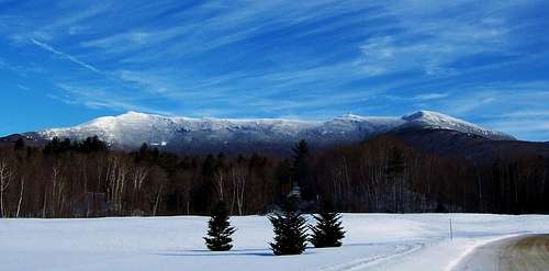 Mount Mansfield in January from Underhill
The weather on Mount Mansfield can be very different from the lower surrounding areas. In winter, blowing snow and clouds are very common conditions on the summit. Above the tree line, complete whiteouts leading to disorientation may occur; be very cautious when ascending in these conditions. Visibility may be only 20 feet, so it is very easy to get lost while ascending or descending from the summit. Use less exposed routes in these conditions, for example use Laura Cowles trail instead of Sunset Ridge (Sunset Ridge is exposed for over 50% of the route).
Routes Overview
There are many trails up the mountain, I will describe a few of the more popular routes. If hiking from the west side of the mountain the most popular place to start is from Underhill State Park. The two most popular routes from here are: Sunset Ridge Trail & Laura Cowles Trail. If you are hiking from the east side of the mountain the more popular route is the Long Trail. The easiest way up the mountain though is from the Toll Road. Here is a good map of the trails on the mountain.
Sunset Ridge Trail:
One-way hiking distance: 3.3 miles
One-way elevation gain: 2600 feet
This trail is very scenic and could be considered a classic. For a good portion of the route you will be above the tree line. This trail has the best views of any trail that ascends the mountain, since so much is above tree line. This route would not be recommended during bad weather or high winds since its so exposed.
Laura Cowles Trail:
One-way hiking distance: 2.7 miles
One-way elevation gain: 2600 feet
The Laura Cowles trail is a more direct route up to the chin, this trail branches off of the Sunset Ridge trail and rejoins it near the chin. Since its more direct it is steeper and much of the hike is through a forested ravine. This route is tougher, but more protected from the elements. Sunset Ridge and the Laura Cowles trail can be easily done as a loop. But I would recommend going up Laura Cowles rather than down.
Long Trail Southbound:
One-way hiking distance: 2.3 miles
One-way elevation gain: 2800 feet
The Long Trail is the most popular route from the east side of the mountain. This trail is very steep, but also sheltered. The Long Trail can also be combined with other hiking routes for a loop hike. You could ascend the Hell Brook trail then down the Long Trail. Or a trip up the Haselton Trail, traverse the summit ridge to the chin then down the Long Trail.
From the Toll Road:
One-way hiking distance: 1.3 miles
One-way elevation gain: 600 feet
The Toll Road is the easiest way to the summit of Mount Mansfield. Information about the Toll Road can be found here. This route starts from the nose and follows the Long Trail north towards the chin. Though its the easiest route most people hiking to the summit do not use this route. The views along the ridge to the summit are superb.
 |
 |
 |
 |
 |
Getting There
To get to the LT and Haselton Trail trailheads follow VT 100 north to Stowe, then take VT 108. The Haselton Trail starts in the Gondola Base Lodge parking lot, the LT trailhead is 0.6 further north.
The Sunset Ridge Trail starts at Underhill State Park. From Underhill Center take the Pleasant Valley Road about a mile north, then take the Mountain Road to its end at the state park (parking fee). From the park follow the old CCC road for a mile to a sharp right turn, where the trail bears left off the road.
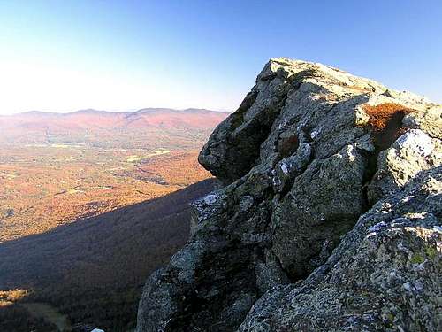 Along Mount Mansfields Summit Ridge
Red Tape
The State of Vermont closes trails on Mt. Mansfield from Mid-April to Memorial Day to protect the fragile vegetation, and also to protect the trails themselves from erosion. The Green Mountain Club discourages hiking on any trails at high elevation during that season.
There are no fees (unless you use the toll road or gondola) and no permit is required.
When To Climb

Rime Ice and Sunset Ridge
The normal hiking season in the Vermont extends roughly from Memorial Day to Columbus Day. Winter conditions above treeline are harsh, but for those with the required knowledge and experience a winter ascent of Mount Mansfield can be a wonderful experience.
The upper 1.5 miles of the Mountain Road to Underhill State park is not plowed in winter. Also plowing on VT 108 stops about 0.3 miles south of the Long Trail.
Camping
Given the short distances most people climb Mount mansfield in a day. There is lodging at the Green Mountain Club's Taft Lodge. A reader has added: "The "lodge rate" is $6 per person. Bring your own stove and T.P. as fires are forbidden and the outhouse was bare. Also, water is available from an untested source - recommend bringing a filter."
Mountain Conditions
While planning a trip check the weather forecast.
In winter trip reports posted on the Views from the Top (VFTT) Vermont Trail Conditions forum should be consulted before a trip. If you find nothing you can post a query at any of the following (they share viewers, it is considered poor form to post to more than one):
- AMC Bulletin Boards
- NE Q&A Newsgroup of VFTT.
Maps
In addition to the map that comes with the Long Trail Guide you may want the North Vermont Hiking Trails map produced by Map Adventures.
External Links
- 4000 footer list for Maine and Vermont
- Hiking the Vermont 4000 Footers
Notes on the routes, with distances and elevation gains. - Underhill State Park website
Official website for the Underhill State Park.
chilkoot - May 26, 2006 3:41 am - Voted 10/10
Growth spurtI believe the official height of Mt. Mansfield was raised from 4393' to 4400' sometime within the last 8 or 10 years.
gjagiels - Oct 25, 2006 2:14 pm - Hasn't voted
Re: Growth spurtCan you find a source for this? I've tried searching for something about this but can't find anything, thanks! Greg
chilkoot - Oct 26, 2006 2:19 am - Voted 10/10
Re: Growth spurtI wasn't able to find anything official on a quick search, but I'll keep looking.
mlongstreet - Jan 27, 2014 8:50 am - Hasn't voted
Re: Growth spurtThe official NGS elevation of the marker pin on top of MT Mainsfield, VT is 4393.2 ft or 1339.05 meters http://vtransmaps.vermont.gov/VOLGIS/datasheets/GS0106.txt
swiffer109 - Jul 15, 2013 5:31 pm - Hasn't voted
Hiking With DogsDon't do Maple Ridge Trail with large dogs, almost to summit 3ft crevasses to jump, not too bad but my 100lb dog was already exhausted from difficult hike up, couldn't do it safely. Go to the left at main trail split. Wish I had known that before.
Walkoutnow - Nov 21, 2017 1:06 pm - Hasn't voted
HP #30Dumping snow all day. Went up Profanity trail via Long trail. Some knee deep post-holing and then complete whiteout up top. Lots of fun and a complete winter wonderland... bit more work though with all the conditions and fresh snow. Good times..
william.drakon - Oct 1, 2018 8:27 am - Hasn't voted
origin of namea dumb little minor thing but the mountain is named for the dissolved town of Mansfield, which was absorbed into Underhill and Stowe
cshanek - Jun 24, 2019 6:05 pm - Hasn't voted
Long Trail TH movedI guess they moved the Long Trail TH in the last couple of years (according to a volunteer). You now park in the Stowe parking lot and walk across the street (away from Mount Mansfield) to Barnes Camp and head North on LT for about a quarter mile or so before crossing the road. The North and South sections of the trail touch now. This allowed my daughter and I to link up the Long Trail with Hazelton for a loop of Mansfield peaks with little to no road walking. Also the nose is closed to hikers due to radiation concerns from the towers up there.