
|
|
Mountain/Rock |
|---|---|
|
|
30.38270°N / 90.57330°E |
|
|
Mountaineering |
|
|
23497 ft / 7162 m |
|
|
Overview
 A village at the foot of the massif
Nyainqentanglha Feng is the highest peak of Nyainqentanglha Shan (aka Nyenchen Tangla, Nyanchen Tanglha), a massive 600 km long range in central Tibet dividing the Yarlung Tsangpo (Bramaputra River) drainage from the Chang Tang (northern high plains). The central part of the main range is about 150 km long. The massif is heavily glaciated, however presently the glaciers have receded dramatically due to low precipitation, exposing sharp ridges and peaks. Snowline in the Nyanchen Tanglha range is as high as 5700 m. The peak has one main peak and three slightly lower sub-peaks.
Nyainqentanglha Feng is located close to Lhasa near the paved Qinghai-Tibet highway. It is bounded by grassy plains of Damshung to the south and the scenic holy lake Nam Tso (4700 m, one of the highest large lakes in the world) to the north. Nyainqentanglha Feng is usually approached from the south, near the town of Yangpachen in Damshung county. Base camp is at the foot of the range at elevation 4800 m. Nyainqentanglha Feng was first climbed in 1986 by a Japanese team.
About 50 km northeast of Nyainqentanglha Feng in the Nyanchen Tanglha range is Samdain Kangsang, 6590 m, located even closer to the highway. It dominates north-central Tibet and has a steep sloped, heavily glaciated summit, but fairly easy to climb.
The peak is one of the three 7000 meter peaks which are located within a three hours of travel from Lhasa.
The other two are Qungmoganze and Noijin Kangsang.
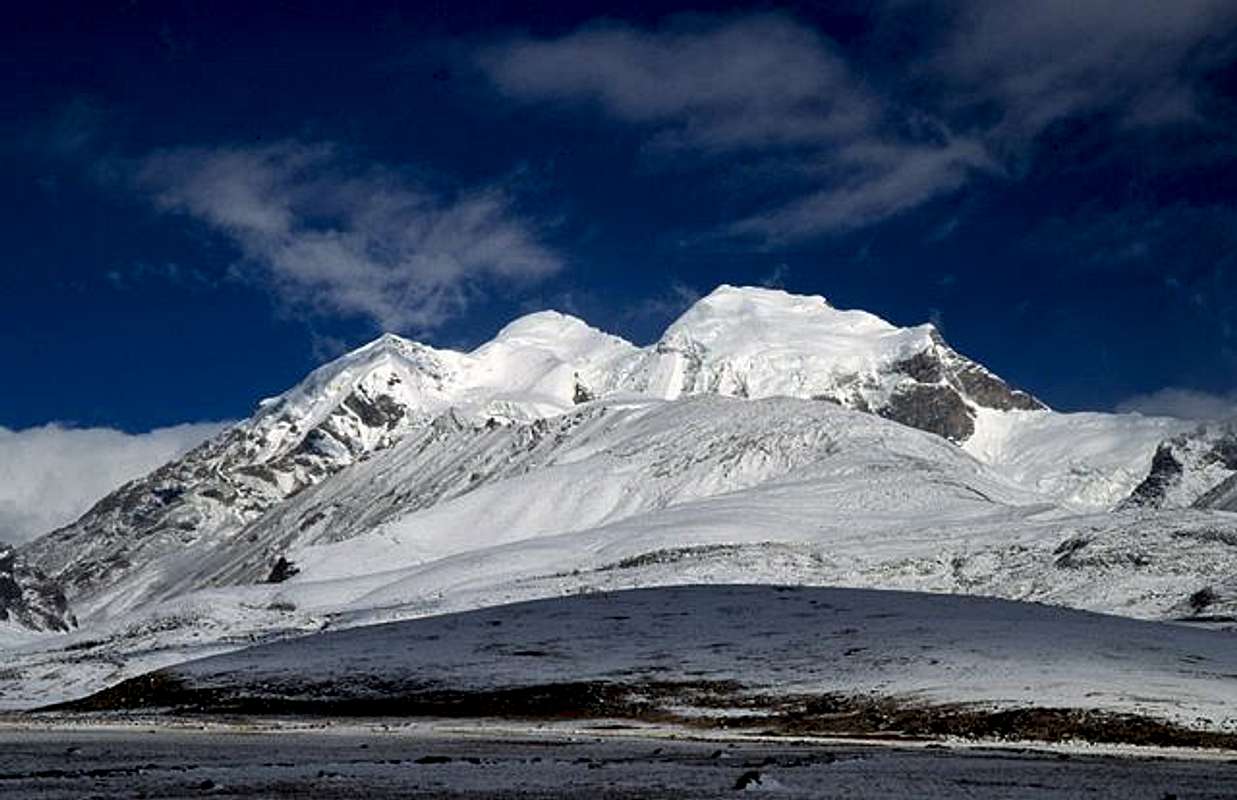
Nyainqentanglha Feng - Main massif. All the three highest summits clearly visible.
Getting There
The peak is conveniently located close to Tibet's provincial capital Lhasa.Travel to Lhasa - By air
There are scheduled flights from Chinese cities of Beijing, Chengdu, Xi'an, Hong Kong and from Kathmandu (Nepal). Most frequent flights depart from Chengdu and the city is usually a stop over point for most flights.
Travel to Lhasa - Overland routes
 Central summit
A graph of the Yunnan Highway can be seen here. Up and down all the way.
Travel - Lhasa to base camp
Take the paved Qinghai-Tibet highway north from Lhasa for 2-3 hours, past Yangpachen town. When arriving at a spectacular, but flat pass, full of prayer flags turn left (north) toward the peak. There's no risk of making any mistakes here, as it is very obvious which is the highest peak in the range. Nyainqentanglha Feng is dominating the landscape completely and even at a distance of 16km it's looming over you.
There is a lot of bus traffic along the highway so getting a ride is easy. Vehicles can be hired in Lhasa, animal transport, if required, can be hired in villages in between Yangpachen and the pass, or north of the pass towards Damshung.
Getting to base camp
Walk for about 15 km towards the range. The terrain is very easy and if acclimatized you can reach the peak in a few hours from the main road. If you're lucky, you may be offered a ride part of the way with some farmers who traffic the area with small tractors. If heading for the valley S of the peak, make sure you don't walk too far before setting camp. There are a quite high risk of rockfalls and even smaller avalanches on these steep sloopes.
Approaching the peak from the north
Head past Yangpachen until you arrive in Damchung. It's about an hour, an hour and a half by car. In central Damchung, take a left and continue over the little river. After a couple of km you see a control post. Stop and pay for the nature preserve admission. The road now starts to go steep up and continues in a tight gorge until it opens up a little bit just before arriving at Largen La/Pass at 5157m. Great views of lake Nam from here. Steep down to the plains close to the lake. There are rough tracks leading towards the west from here. Even if you now will be travelling along the northern faces of the peaks, the melt-off from them may create streams and rivers which can't be crossed at certain times of the year. An alternative to jeeps is to go with yaks to the foot of the mountain if the streams are to wild.
Red Tape
 The main peaks
Foreign citizens are required to join a tour group in order to enter Tibet legally. Within Central Tibet foreign citizens can nowadays travel almost anywhere without additional permits. If uncertain about an area's status, ask a travel agent or in your hotel. Sometimes you need to obtain county-specific permits to travel to closed areas, which can be processed by a travel agency in Lhasa. Nyainqentanglha Feng is located in an open area (Damxung county), therefore additional permits are not required.
Climbers are required to pay a fee to China Tibet Mountaineering Association and obtain a permit for climbing.
Address: No. 8 East Linkhor Road, Lhasa, Tibet, China Fax;+86-891 36366
The peak fee is $1080 and up to 12 people can climb on the same permit. Usually, you also need a liaison officer, but this issue is negotiable. The CTMA (Chinese Tibetan Mountaineering Asociation) will try to sell you guides, porters, yak-drivers, "special-high-altitude-yaks" cooks, transport etc ad nauseum, but all of it is also negotiable.
A direct answer to a direct request about the peak fee for 2006 resulted in this:
MOUNT NYENCHEN THANGLA------------------------------MAXIMUM DAYS 30
USD2200/PER PERSON (ADD USD300/P.P ENTRY & EXIT VIA ZANGMU)
1PAX GROUP(Solo) ADD US$1000 AS THE REGISTRATION FEE FOR BELOW PEAKS
NOTE:
--ABOVE COSTS BASIS ON ENTRY & EXIT VIA ZANGMU. IF FROM LHASA ADD USD100/PER MEMBER/ PERDAY AND USD50/PER SHERPA/ PERDAY DURING STAYING IN LHASA.
--ADDITONAL CHARGE USD50/PER PERSON/ PERDAY OVER THE LIMITATIVE TIMES.
--THE RATES US$ 1 = RMB 8
Ⅰ FEE FOR NEPALESE STAFF
HIGH ALTITUDE SHERPA ---------------USD1200/PER PERSON
BASE CAMP COOK -----------------------USD 800/PER PERSON
Ⅱ ENVIRONMENTAL FEE
8000M -------------------------Deposit fee USD500/PER EXP
7000M ------------------------- Deposit fee USD250/PER EXP
6000M ------------------------- Deposit fee USD150/PER EXP
ENVIRONMENTAL DEPOSIT FEE SHOULD BE HANDED BY LIAISON OFFICER. ACCORDING TO THE REGULATION WE WILL KEEP SOME OF MONEY AT LAST WHICH WILL USE FOR FUNDS IN EVERY YAEAR’S CLAEARAION. REST OF
DEPOSIT FEE WILL NOT REFUND,IF CLIENTS DON’T TAKE BACK THEIR GARBADGES..
USD 20 / PER PERSON BY 8000M
USD 15 / PER PERSON BY 7000M
USD 10 / PER PERSON BY 6000M
Ⅲ THE ALL ABOVE COSTS INCLUDE THE SERVICES:
(A) EXPEDITION PERMITS FEE, VISA INVITATION LETTER ETC.
(B) TRANSPORTATION FROM BORDER ZHANGMU OR LHASA AIRPORT TO BC
AND BACK FOR MEMBERS, STAFFS AND EQUIPMENT
(C) JEEP FOR MEMBERS ,TRUCK FOR STAFFS & BAGGAGE (ONE JEEP FOR 4 MEMBERS)
(D) LIAISON OFFICER AND INTERPRETER
(E) ALL ACCOMMODATION ON FULL BOARD BASIS IN THE WAY
(F) SIGHTSEEING & GUIDE
(G) FOR MOUNT QOMOLONGMA 4 YAKS PER MEMBER CBC TO ABC & 3 YAKS PER MEMBER ABC TO CBC. FOR ALL OTHER MOUNTAINS 3 YAKS PER MEMBER CBC TO ABC & 2 YAKS PER MEMBER ABC TO CBC
(H) 1 YAK EACH FOR EACH HIGH ALTITUDE SHERPA CBC- ABC GOING AND RETURN.
(I) 1 YAK EACH FOR ABC MEMBER AND TREKKERS
(J) 1 YAK CARRY 40K.G IN SPRING,60 K.G IN AUTUMN
NOTE:NOT INCLUDE FOOD,TENTS AND EQUIPMENTS IN MOUNTAIN AREA
Basic info about Lhasa
 Western summit slopes
The most convenient accomodation is to be found close to the Barkhor Square, which also have most of the sites of cultural interest close by.
Dormitories in budget hotels starts at 15Y/person, cheap doubles goes for 60Y/room and more comfortable doubles with attached bathrooms starts at 140Y/room.
Recommended places in this part of the town is the Snowlands Hotel, Kirey Hotel and Yak Hotel.
The above mentioned area is a ten minute walk from CTMA.
Lhasa's old Holiday Inn, nowadays re-named to Lhasa Hotel is located in the western end of the city. Good doubles range in between 600-800Y/room, but compared to many other places, it's severly overpriced. You can for example get a room at the same quality level in the Yak Hotel for less than half that price.
Tibettrip.com has a nice guide of hotels and hostels in Lhasa.
Supermarkets are located all over Lhasa and are filled with food which is of interest for mountaineers, i.e. instant noodles, powdered food, dried fruit etc. Don't expect to find any "high-tech" mountaineering food here though.
The only place that has it on a daily basis is the great mountaineering shop opposite to the Banak Shol Hotel. Basically everything, for most types of mountaineering are readily available there. The exception is ropes, which always seems to be in short supply and of doubtful quality.
There are more outdoor/mountaineering shops all over Lhasa, but most of them sell pirate and copy gear of very mixed quality.
If you're lucky, you can pick up second hand gear dirt cheap.
An easy and cheap way to travel around in the city is to go with taxi, which has a standard fee of 10Y wherever you wanna go within the city limits.
Buses are 2Y/ticket, but if you don't know Mandarin,it can be a hard undertaking to find your way around.
At the time writing the Chinese Yuan is 8.05 to the Dollar.
When To Climb
The peak can be climbed all year around, but the most common time is from May to October. Some years, when it's a heavy monsoon the peak can be affected and the result is usually very unstable weather and sudden rain storms. The winter brings clear and more reliable weather patterns, but the cold can be grim. On the mountain's southern sides in particular, the snow can be very deep.Mountain Conditions
 Prominent peak nearby
The weather in Lhasa is monitored by a lot of weather stations, but even if the city is fairly close to the peak, the conditions can be very different. A mountain range is separating Nyainqentanglha Feng from Lhasa and the elevation in the valley where the peak is located is at a much higher altitude (4500m vs. 3650m).
The weather in Lhasa.
The local (radio) weather forecast is in Chinese and Tibetan language only and if you don't understand these languages, the best way to find out is to ask locally.
Camping
Officially camping is forbidden in China, but now one seems to care at all where you pitch your tent. If in doubt, ask the local nomads if you can pitch it close to one of their many camps. I have personally never gotten a negative answer and this tactic also gives you the benefit of having your tent guarded by your new-won friends.Additional Info
 Nam Co and the range seen from the north
The first ascent of the main summit was done by a Japanese team as late as 1986. At least four Chinese teams have made it to the summit, but I'm not 100% about which of the summits all these teams climbed. The first of them reached the summmit in 1989, the second in 1992.
The first ascent with westerners in the team was made in 1990.
Mick Fowler put up a new route in the Nyainqentanglha Feng post monsoon, 2005, which he regards as one of his best ever.
High mountain sports magazine, May 2000 issue has a story about attempts of two of the peaks.
Last time I heard, the 7046 meter high Nyainqentanglha IV was unclimbed and in that case it's the last of the main peaks to be summited.
I'm interested in knowing about more ascents.
Commercial Expeditions
Country Holiday Pvt. Ltd. can arrange a group deal to the peak.Credits & Remarks
 Damxung and the range
The page was initially set up by Gordonye. Some of his info is still on the page in an unaltered way.
Photos from the northern side and from the way to the peak will come later.
If you have summited the peak and want to adopt this page, please drop me a line and I'll transfer it to you.