
-
 13540 Hits
-
 81.18% Score
-
 13 Votes
|
|
Mountain/Rock |
|---|---|
|
|
37.22150°N / 118.7507°W |
|
|
12989 ft / 3959 m |
|
|
Overview
|
|
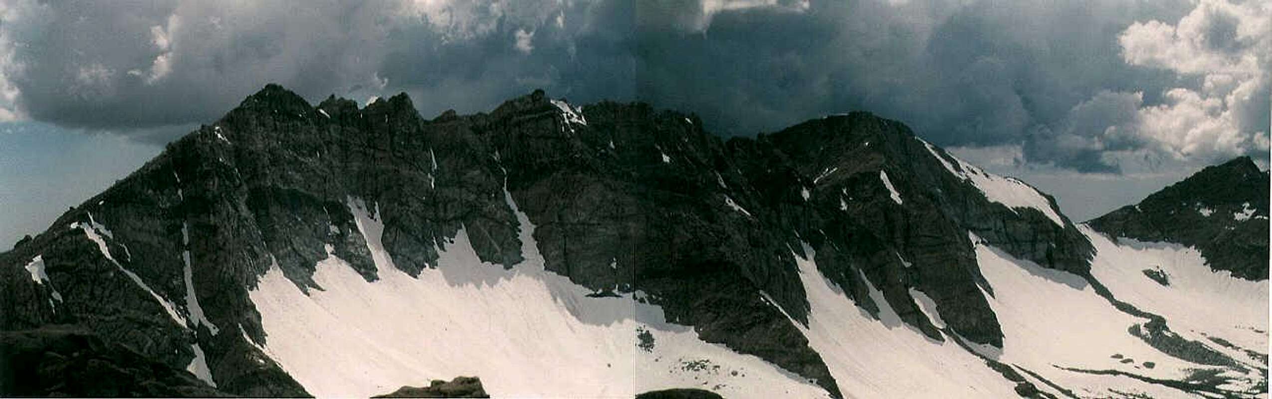
Matthes Peak (Peak 12,989'+) is a large mountain at the center of the Glacier Divide along the northeastern border of Kings Canyon National Park, in the Sierra Nevada of California. This peak is infrequently climbed (~4 ascents per year). The easiest ascent route is from Evolution Valley, up the class 2 southwest slope. The north face, a beautifully banded and undulating wall, should yield some high quality technical rock routes.
The glaciers that line the north side of the Glacier Divide are named the Matthes Glaciers after the noted geologist Fracois-Emile Matthes, who described the sculpting of Yosemite Valley by ice in his book "Incomparable Valley: a Geologic Interpretation of the Yosemite." The peak, though unofficially named, is a fitting second monument to Matthes (the first being the Matthes Crest in Yosemite National Park).
To east and west of the peak, the Glacier Divide houses about half a dozen pocket glaciers. To the south and north are huge, glacially carved valleys. At the foot of the north face are lakes and pools tinted turquoise by the glacial talc carried from the glaciers above by streams that flow under the moraines.
The first recorded ascent I've been so far able to determine was by Andy Smatko and party, summer, 1967. There was an older 'document' on the summit, a very old piece of paper or tobacco leaf (dark brown) stashed in a tobacco tin that looked 1930's-ish. Nothing was legible on this scrap, though.
|
|
Getting There
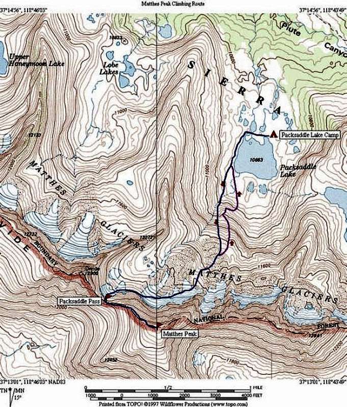
EAST APPROACH: From Highway US-395 in Bishop, drive up Highway CA-168 to the North Lake turn-off, just before Lake Sabrina. Park in the hiker parking area, about 1/2 mile below the campground. Hike through the campground and up the Piute Pass Trail and over Piute Pass. Continue down the Piute Pass Trail to a point between Desolation Lake and Lower Golden Trout Lake. Hike cross-country to the outlet of Golden Trout Lake. Cross Piute Creek and contour west into Packsaddle Lake basin.
WEST APPROACH: From Highway CA-99 in Fresno, drive east on Highway CA-168 past Huntington Lake to the Kaiser Pass Road. Continue on Kaiser Pass Road to a 'Y' junction and go right towards Florence Lake. Park at Florence Lake and either take the ferry or hike around the lake (3.5 miles), then hike up along the San Juaquin River to the south-bound Pacific Crest Trail junction. Go left (across a bridge) and hike up into Evolution Valley. From the vicinity of McClure Meadow, hike north onto a broad bench with a large lake near the base of the peak.

|

|

|

|

|
Red Tape
Wilderness permits are required for overnight stay.
For EAST APPROACH, obtain permits at White Mountain Ranger Station, 798 North Main Street, Bishop, CA 93514. Phone number is 760-873-2500.
For WEST APPROACH, obtain permits by writing to Sierra National Forest, Pineridge Ranger District, P.O. Box 559, Prather, CA 93651
...or...
Call the ranger station on the Kaiser pass Road before 'Y' intersection - 559-877-3138. This station is on a remote forest road - I could not find an address, and I'm not sure it really has one.
...or...
The Eastern Sierra Nevada Logistics Page, in the "Red Tape" and "Contact Info" sections, has links to the various agency web sites and information about obtaining reservations.
When To Climb
Best season is July to October. November to February would involve much fresh snow and possible avalanche danger. March to June would involve long ski approach.

|

|
Camping
EAST APPROACH: Best camping is near Packsaddle Lake, fair camping in the vicinity of Lower Golden Trout Lake.
WEST APPROACH: Best camping is near McClure Meadow in Evolution Valley. The bench above McClure Meadow is above treeline, so sites here would be more exposed.
Further Reading
Eastern Sierra Nevada Logistics Page (highly recommended)
The High Sierra: Peaks, Passes, and Trails 2nd ed. (R. J. Secor) - P 298 mentions neighboring Peak 12,900' west of Packsaddle Pass, but only gives difficulty and FA. Packsaddle Pass is discussed on P 267.
External Links
- TopoZone Map
Large TopoZone map of Matthes Peak and surrounds.