
|
|
Mountain/Rock |
|---|---|
|
|
36.62960°N / 105.2125°W |
|
|
Colfax |
|
|
Hiking |
|
|
Spring, Summer, Fall, Winter |
|
|
12441 ft / 3792 m |
|
|
Overview
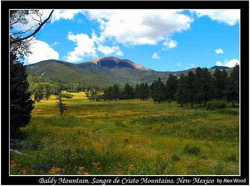
Baldy from Below Miranda
Baldy Mountain is a peak located on Philmont Scout Ranch and is a part of the Sangre de Cristo Mountains in northern New Mexico. It is the highest mountain on Philmont and is also the highest in a subrange called the Cimarron Mountains. According to listofjohn, Baldy Mountain ranks as the 25th highest and as 21st most prominent with 2,701ft of prominence. Formerly a site of fervent gold mining in the days of Beaubien and Miranda, the mountain and its surrounding lands eventually came into the possession of the Boy Scouts of America through a series of land donations that now comprise Philmont.
The mountain forms a gentle arc above the treeline which is comprised of loose scree. Climbing through this can be difficult, so it is best to stay on the trails if possible. To the northwest is a ridge which connects to the western face of Baldy, while ridges toward the south and east make for a fairly easy climb. Baldy's neighbor, Touch-me-Not is around 300ft lower and can be ascended in the same day as Baldy via the south ridge. From the summit of Baldy Mountain, there are views of the Wheeler Peak Wilderness Area, the Truchas Peaks (Pecos Wilderness Area) , Eagle Nest Lake, Latir Peak Wilderness Area, "Little Costilla and even views of Colorado including Culebra Peak (southernmost 14er in Colorado) and the Spanish Fork Peaks.
Route Info
If you are hiking Baldy Mountain, you are most likely on some sort of trek at Philmont. This is the only legal way to do this summit. See the Red Tape Section for more about that.
The average crew will be on a two week trek at Philmont. While not all crews go up to Baldy, those that will go up usually go up somewhere in the middle of their trek, no less then four days out of Base Camp. Usually, crews will be camped at either the base of the North Ridge (Copper Park) or at the base of the South Ridge (around Baldy Town). For more information about camping, see the Camping section of this page. The summit day for Baldy is a long day for any crew and is often made worse by the summer monsoons. For all campers at Philmont, they will go up and down either the North or South ridges of Baldy. The main reason why Philmont does that is so each crew can do program at French Henry or to pick up food at Baldy Town.
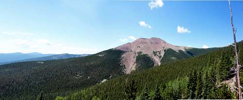 Baldy Panorama
If you are camped around Baldy Town (Miranda, Ute Meadows, Ewells Park, Baldy Town), the South Ridge- From this direction, you will be heading up the South Ridge of Baldy. The route really begins at Baldy Town. From here, you begin to head towards the west. The trail begins to switch back through dense groves of aspen. Keep an eye out for old mining activity! The trees begin to thin out at around 11,730ft. The route begins to head directly up Baldy's South Ridge. In this section, you gain around 700ft in less then half a mile. Past tree line, it is a really loose scree slope, which can be made alot worse by wet conditions. Baldy has two summits. The one to the west is the actual high point. But check them both out because the views for both are unique. From Baldy Town to the summit its around 3.5 miles with 2,400ft of elevation gain.


Copper Park/French Henry, the North Ridge- The only camp used to access Baldy for the North Ridge is Copper Park. From Copper Park, you will begin to head west. Just outside of camp, you will see a sign directing you to the north, towards Greenwood Canyon and Baldy Follow this. A quick note about Greenwood Canyon is that, according to Mark Doiron, it used to be called "Cottonwood Canyon" on some of the older maps. Also, another note about Greenwood Canyon is that some crews will be in the the Valle Vidal and will have to come up and over the pass and down into Copper Park. This is particularly annoying because the next day, their itinerary will have them go back up to that same saddle to do Baldy. There are many many switch backs on this route. You will get to a pass/saddle on the ridge. The trail on the other side goes down to Greenwood Canyon. You want to head up the ridge. Take a left (west) up the ridge. Around tree line, you hit a very rock ridge-line. However, past this, the hiking is quite easy and very very enjoyable. You find yourself on a a beautiful alpine ridge with beautiful alpine tundra. Look out for marmots and elk too. Also, keep an eye out for old mining activity. The views are also endless and everywhere on this ridge. All in all, on this route, you spend about 1.5 miles above treeline, so keep an eye for the weather. At 12,100ft, you will reach an old mine (see the next section for information about that). From here, its a scree slope with 300ft of elevation gain. As said before, Baldy's summit is the western most of the two summits. From Copper Park to the summit, it is around 4 miles with just under 2,000ft of elevation gain.
Note: I said it in the camping section later on, but this is the primary route up Baldy's north side. Philmont used to run a trail straight from Copper Park through the canyon up Baldy's North Face, which is an immense scree slope. However, due to the amount of injuries from the scree slope and from residual snow, Philmont closed it off around the 2007 season. The ridge is a much better and more scenic option to the direct route up the North Face.


Note: As said before, most crews, no matter which side they start on, will either go up or down each route to make a big loop out of the day.
Off Ranch, from Eagle's Nest- Because Philmont owns Baldy's summit and everything east of the ridge, this route is technically of limits. But if you were going to do it, there is an old mining road that goes up the west slopes of Baldy. That is really the only plausible way to access Baldy if you are not a camper or staff.
From Maxwell Turnaround- This used to be a starting point for campers at Philmont, however, Philmont closed it down. If you are staff at Philmont, you can still drive to the turnaround. From here, it is easily possible to do Baldy in a day.
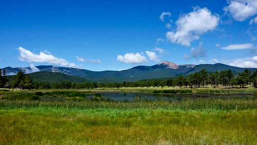
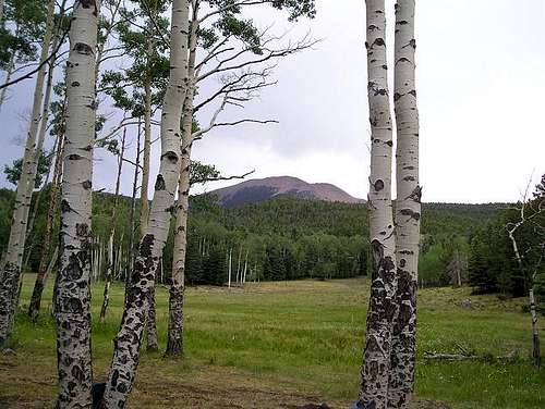 Baldy from Miranda
History of Baldy Mountain: A Gold Rush

Mystic Lode Mine
Baldy Mountain has seen EXTENSIVE mining over the years. Gold was discovered around 1867 on Baldy Mountain and mining operations began in the area. Gold wasn't the only precious metal on Baldy though; copper was also found in great quantities. At around 12,144ft on Baldy just below the north ridge, the Mystic Lode copper mine was developed, yielding vast amounts of copper. This mine is one of the more famous mines at Philmont because it is so close to Baldy's summit. Turquoise colored rocks (not actually turquoise, but copper and iron enriched) litter the scree slope to Baldy's summit above the mine. Even though there were large quantities of copper on the mountain, gold was definitely more sought after.
The history of gold mining on what is now Philmont began around the end of the Civil War, around 1866. Many U.S. soldiers were stationed in the West as the U.S. Army was driving out the American Indians. The story is that one of these soldiers befriended an Indian, who happened to give him a shiny rock. The shiny material in the rock was found to be copper. Wanting to see where it came from, the soldier and two of his friends went up to investigate, and found gold. However, they could not stay for long to mine the gold. Unfortunately, by the time they returned the next year, the area was overrun by miners. Miners begin a rampage on the mountain by strip mining areas that they thought had gold. Also, some hydraulic mining took place at the base of Baldy's north face around French Henry. Claims popped up all over the mountain as everyone began to seek their fortune within Baldy Mountain.
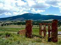
Elizabeth Town
When many people think about the gold rush on Baldy, they only think about where it happened on Philmont property. True, much mining did occur on the east, north and south faces of Baldy, but there was also lots on the west face (off ranch). In fact, that was one of the key points in accessing the mountain. Located below Baldy's West Face sits Elizabethtown, which is a ghost town that used to serve as one of the main hubs for the gold mining activity on Baldy in it's hay-days. Roads used to (you can still see evidence of them today)lead up from Elizabeth town to the Mystic Lode mine at an elevation of around 12,100ft. Like most ghost towns, Elizabethtown began when the gold was found (1866) and then was abandoned once the gold began to diminish on Baldy in the 1930's.

Old Mineshaft
Baldy wasn't the only place on the Philmont that had gold. Many other mines were run and operated well into the early 20th century. However, Baldy Mountain did and still takes the award for having the most gold in the area. A large vein of gold is said to still lie under Baldy to this day, but extracting it has not been feasible. Estimates of the value of gold go well over 1 million dollars. Why don't they mine it? Well, they would have to tear apart the mountain to get the shiny stuff and that process would cost way more then it would yield. In fact, its a common joke at Philmont that some day the mines under Baldy will collapse and Mount Phillips will be the highest mountain on Philmont Scout Ranch. There are about 70 miles of mines in the whole mountain! All and all in the Baldy gold rush, around $4 million were made.
Today the mining history is readily visible to those who visit Baldy's summit. On the ranch, Philmont has two mining themed staffed camp: Cyphers Mine (south country) and French Henry (north country, just below Baldy's north face). French Henry offers visitors to Philmont a mine tour into the Aztec Mine. Along with that, campers can use various basic mining techniques to try to find their own gold. Gold is found almost every week at French Henry during the summer. Most of it is gold dust, however, occasionally bigger pieces are found. I think it was 1995 when a scout found a chunk of gold worth around $250! The best thing about mining at Philmont: You find it you keep!
The mining activities around Baldy Mountain ceased a few years before Philmont began to take place. By 1941, Waite Phillips had already donated 130,000 acres to the Boy Scouts. However, it wasn't till 1963 that Baldy Mountain became apart of Philmont when Norton Clapp donated around 10,000 acres. This addition of the Baldy Mountain made Philmont complete. However, with the addition of Baldy, Philmont had to deal with all the old mining remains; open mine shafts. To this day, Philmont is always on the lookout for open mine shafts. Old mine shafts are dangerous! Although this danger lurks in and around Baldy Mountain, this history of the old gold rush lives on and is vividly present to all those who gain Baldy's summit.
Red Tape
The summit of Baldy, along with the eastern half of the mountain, lies on Philmont property and technically is only open to scouts at Philmont. The western face, however, is accessible to anyone. While a quick dart to the summit wouldn't hurt, it is technically illegal unless you are a camper at Philmont, on staff or have special permission. This peak does see a fair amount of "off ranch" hikers due to it's elevation and prominence. Also, unlike other peaks in Philmont that are located deep inside of the ranch, Baldy lies at the NW corner, making it easier for other to hike.
Now, if you are going to hike it and your not a camper or staff, just be respectful of those on or around the summit. Philmont has worked hard to make to make the ranch a place where it can instill memories that will last a life time upon those who visit it and for most, Baldy Mountain is thee apex of their experience at Philmont. Don't ruin it for them!
 Baldy and Touch-Me-Not
Camping
There is a private campground along Highway 64 in Eagle Nest that is a convenient place to stay in town. However, if you're feeling more adventurous, I would highly recommend finding a spot on the south ridge between Baldy and Touch-Me-Not. This is an excellent spot to stay and catch dazzling sunset and sunrise views. Also, the Carson National Forest is located all around Baldy Mountain. For camping information in the Carson National Forest, click THIS LINK.
For Philmont scouts only, the camps closest to Baldy Mountain are Copper Park and Baldy Town.

Baldy Town
Baldy Town is a staffed camp located just at the base of the SE face at around 10,000ft. At this staffed camp, there is a commissary, back-country store, and SHOWERS! The activity at Baldy Town is Conservation Project (which each visiting crew is required to do. They can choose to do it at a variety of camps). The porch of the main cabin at Baldy Town boasts one of the best views on the entire ranch with endless views down south. When crews hike Baldy, they will have a two day layover at a camp. Baldy town does not have that many sites, so usually crews will camp at Miranda or Ute Meadows and just pass through Baldy Town. From Baldy Town, crews will head west up the mountain and then meet up with Baldy's South Ridge.

From Copper Park
Copper Park is a trail camp located at the base of Baldy's Eastern Ridge at around 10,500ft. The main trail to Baldy used to be located on the North Face of Baldy and would start right from Copper Park. However, Philmont has now shut down that trail (to dangerous for a BSA camp). The main route to Baldy now lies on Baldy's North Ridge (often called "O.A. Ridge". There used to just be a trail that went up and over the ridge for campers to access Greenwood Canyon. Now the trail follows the ridge towards Baldy. For those that go to Copper Park, the closest staffed camp is French Henry, which is a mining camp. There are mine tours there and a bunch of different mining activities such as gold panning. Keep an eye out for old mining cabins and mine shafts while in this area.
Mountain Conditions
Summer Monsoons
Baldy Mountain along with the Sangre de Cristo Mountains are notorious for their brutal monsoonal seasons. This is the main issue with any peaks in this region above treeline. These storms bring lots of lighting and rain/hail. They aren't your average storm, they have the potential to kill people are not to be taken lightly.
In 2007, lightening struck a crew on Baldy Mountain. Read more about it HERE.
Philmont stresses this fact to all of their campers. Storms roll through the area almost everyday in mid to late summer. If you see clouds approaching, be ready for a fast descent. Don't put your life or others in jeopardy by trying to gain the summit with a storm approaching. Baldy Mountain will always be there. KNOW BEFORE YOU GO! Now this is a little harder to do while on a trek at Philmont in the summer, but you can still observe the weather. While at Baldy Town or French Henry, ask the staff about weather conditions. On your summit day, check the weather out for yourself-keep an eye out. Clouds aren't always a bad thing. BUT, if you see rain approaching or hear thunder, that is your signal to head down. Better to be safe then sorry! Most of these storms don't last very long anyways. So you can easily wait out a storm and still make the summit that day.
Before you hike Baldy, you should have adequate knowledge of what to do in a lightning storm. Your ranger will inform you of Philmont's lightning procedure and will have most likely practiced it before hand to. But the basic fact is that in a summer monsoon with lightning, get down below treeline! For more information regarding lightning procedures, visit the Philmont Health and Safety Page.
Enough of that...
Getting There
To Eagles Nest (closest town to Baldy mountain)- From either Denver or Albuquerque it will be about a 4-5 hour drive. Take the I-25 to exit 454 in Raton. Then take Highway 64 west, through Cimarron and Ute Park to Eagle Nest. This is the way you would have to approach if you don't have permission to hike this peak (ie you're not a camper, staff, or a V.I.P.). If you are a camper, you need to get to Cimarron and then to Philmont CHQ.
To Philmont Camping Headquarters from Cimarron-Take Hwy 21 south for about five miles. Philmont Camping Head Quarters (CHQ) will be on the right side. This is where you will go if you are a camper at Philmont.
Note: If you are staff or have special permission, you can drive up to the Maxwell Turnaround (close to Ute Park). The road isn't the best, but it is the shortest route to access Baldy.
External Links
- Philmont Scout Ranch
The official website with everything you need to know about Philmont - Philmont Information
The un-official Philmont website. This page has descriptions of all staffed camps at Philmont along with a list of typical itineraries and links to sites with photos of Philmont. - Carson National Forest
Check this page for details on other destinations or current conditions close to Baldy Mountain. - Weather Conditions
Current weather conditions as forcasted by NOAA
Misc
If you have any more additional information or photos, please contact me or add them to this page. Thank you!