
|
|
Mountain/Rock |
|---|---|
|
|
42.17760°N / 74.2305°W |
|
|
4040 ft / 1231 m |
|
|
Overview
Hunter Mountain
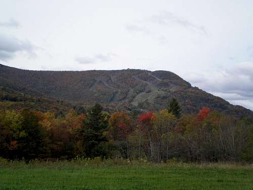
Hunter is the second highest in the Catskills. Hunter Mountain Wild Forest encompasses almost 11,000 acres in the northeast portion of the Catskill Park. The forest is located in Greene County in the towns of Hunter, Jewett, and Lexington. The area can be accessed from NYS Route 214 and Greene County Route 6 (Spruceton Road). Watch for trailheads and forest preserve access parking areas along these routes. Hunter Mountain Wild Forest is mountainous. There are six main peaks located within the forest; Hunter Mountain (4,040'), Southwest Hunter (3,740'), Rusk Mountain (3,680'), Evergreen Mountain (3,360'), Pine Island Mountain (3,140'), and Packsaddle Mountain (3,100'). The area is rugged and there is limited access to the Forest. There are several year round and seasonal stream which either flow to the Schoharie in the north or to the Westkill in the south.
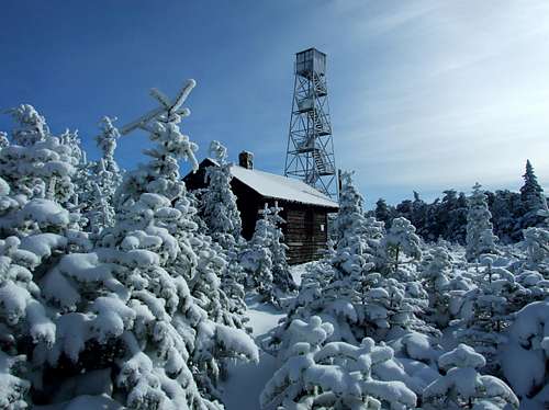
Hunter Mountain Fire Tower
Routes
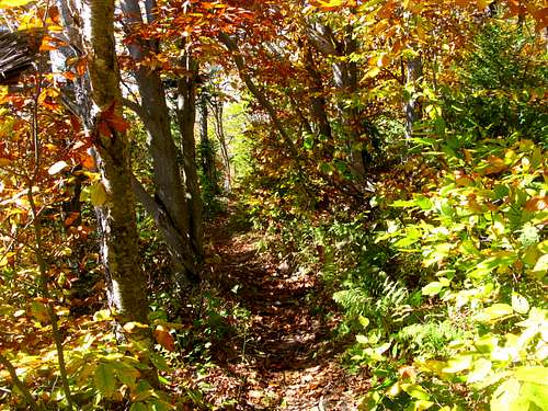
along the Hunter Mountain trail
The summit of Hunter Mountain can be attained by four different routes. Two are located within the Hunter Mountain Wild Forest.
Diamond Notch Trail (Blue Trail Markers)
This trail was developed during the 1937 season primarily as a ski trail from the Stony Clove Road (Route 214) near Lanesville to the Spruceton Road near its junction with the old Spruceton-Hunter Road.A gentle three mile hike with an ascent of 1,300' from the south of the notch, and a 700' ascent from the north to the notch. Hikers will find the Diamond Notch Lean-to just to the north of the notch, and can visit Buttermilk Falls at the Devil's Path Junction. This beautiful waterfall drops about 25 feet in an amphitheater-like setting, with a small meadow nearby. Just to the east of the Falls, the Devil's Path enters the Hunter Mountain Wild Forest.
The northern portion of the Diamond Notch trail, leading from the parking lot along the Spruceton Road to the Falls, is a popular 2 mile round trip family hike and is identified as such in the "Catskill Adventure - Day Hikes and Paddles for Families" brochure.
Becker Hollow Trail (Blue Trail Markers)
This trail begins at the trailhead along State Route 214, just north of Devil's Tombstone Campground. This short trail is arguably the most difficult hike in the Catskills - climbing nearly 2,000 feet in two miles. However, for those willing to exert the energy, the reward is a short route to the summit of Hunter Mountain with it's spectacular views.
Spruceton and Colonel's Chair Trails (Blue Trail Markers)
This 3.6 mile trail is to the fire tower access road. Along it you can visit the John Robb leanto and take in good views of the Westkill Mountain Wilderness and Spruceton Valley. A short one mile trail leads off to the north, just above the leanto, to the upper ski lift area on Hunter Mountain. This yellow marked trail, known as Colonel's Chair, will also lead you to the resort's snack bar, which is seasonally open!
Devil's Path (Red Trail Markers)
This trail because of the rugged country which it traverses, is known as the "Devil's Path." The easterly section over the ridge of Indian Head, Twin, and Sugarloaf mountains was first opened in 1930. The westerly continuation over Plateau and Hunter Mountains was opened in 1935. The trail follows the height of land on the range for almost its entire length and beautiful vistas of the Catskill region are enjoyed from numerous points along the way.4.2 miles of this very popular trail traverses the unit. This hike is considered strenuous, rising approximately 1500 feet within two miles. Views along the trail are spectacular, and include the Spruceton Valley, Plateau Mountain, and south to Ulster County. A seasonal spring and the Devils Acre leanto are located near the summit of Hunter Mountain at the trail junction of the Devil's Path and the yellow-marked Hunter Mountain Trail.

Heading down with family...
Getting there

Hunter Mountain
From the South: Hunter Mountain is located 120 miles north of New York City via New York State Thruway I-87 North to Exit 20, travel North on Route 32 to Route 32A North to 23A West. Travel 10 miles until you see the entrance to Hunter Mountain on your left.
From the North: Take I-87 South to Exit 21. Travel East on Route 23 to Route 9W South, then onto 23A West. Travel 22 miles until you see the entrance to Hunter Mountain on your left.
By Air
Nearest International Airport: Albany Airport - 60 Miles
Nearest Domestic Airport: Albany Airport -
By Rail
Nearest Train Station: Amtrak - 25 Miles
External Links
- Catskill 3500 Club
- Hunter Mt. Weather
Provided by ski resort
- The Catskill 3500 Club Peaks
Descriptions of all 35 of the Catskill Peaks that exceed 3,500 feet elevation.
Drazil - Sep 21, 2004 7:55 pm - Hasn't voted
Untitled CommentPlease go ahead and add. Thanks, Liz
Drazil - Aug 16, 2002 10:08 pm - Hasn't voted
Untitled CommentThank you for pointing that out. This page still needs lot of work...
Liz
Alpinist - Sep 21, 2004 6:41 pm - Voted 10/10
Untitled CommentDrazil - Sep 21, 2004 7:55 pm - Hasn't voted
Untitled CommentPlease go ahead and add. Thanks, Liz