
-
 79369 Hits
-
 91.13% Score
-
 34 Votes
|
|
Mountain/Rock |
|---|---|
|
|
46.74400°N / 121.6997°W |
|
|
Hiking, Mountaineering, Trad Climbing, Scrambling, Skiing |
|
|
Spring, Summer, Fall |
|
|
6971 ft / 2125 m |
|
|
Overview
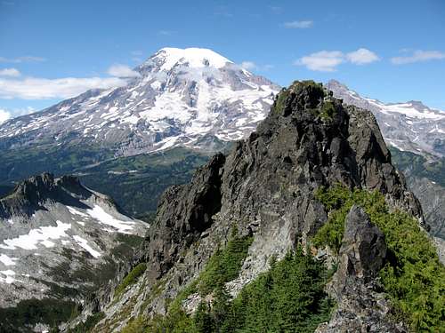
Unicorn Peak is the tallest peak in the Tatoosh Range offering a moderate 6 mile round-trip day climb that provides commanding views of Mount Rainier. In early season, it is a good mix of hiking, snow travel, and low 5th class technical rock climbing. The views of Mount Rainier from the summit are breathtaking but to the south you can also see Mount Adams, Mount St. Helens and on a very clear day, Mount Hood! The north face of Unicorn Peak is a huge wall of fairly bad rock that inspires awe for those who gaze but isn't suitable for multi-pitch technical ascents. The standard approach is via Snow Lakes off the Stevens Canyon Road to the north. This climb is better done in spring when the large scree slopes are covered in well consolidated snow. The final bit to the summit brings you around the west side of the summit block and finally up the south side via a short, 50 foot rock climb. This peak is a great place to bring beginners as long as someone in the group can safely lead.
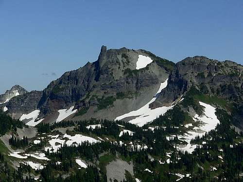 Unicorn Peak from Plummer Peak Unicorn Peak from Plummer Peak |
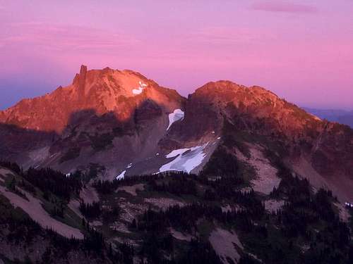 Really gorgeous evening on Pinnacle Peak Really gorgeous evening on Pinnacle Peak |
Getting There
From Portland:
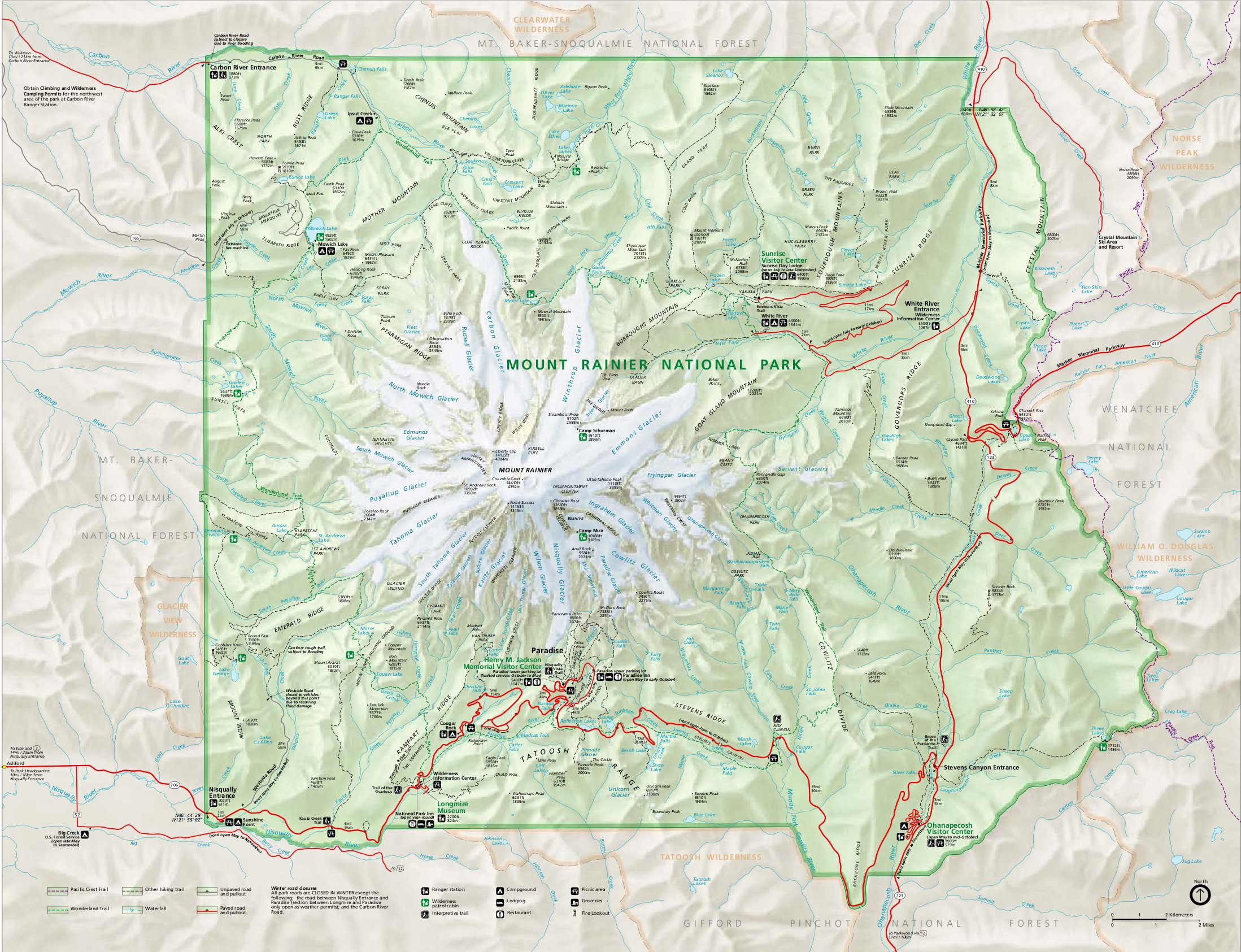
Take Interstate 5 north to Exit 68 and turn east onto US highway 12 and continue for 30 miles to Morton and State Highway 7. Take SH 7 North to a junction in the small town of Elbe. Turn right and follow this road through Ashford into Mount Rainier National Park. There are signs for Mt. Rainier National Park at nearly every junction.
From Seattle:
To reach the West entrance by Longmire, take Highway 7 from Tacoma 35 miles South to Elbe. At the junction, follow the signs to Mt. Rainier National Park and drive East about 15 miles to the park entrance.
Once inside the park, follow the main road east to Longmire and continue east past the turn off to Paradise and onto Steven's Canyon Road. Unicorn Peak is in the Tatoosh Range south of Mt. Rainier. The standard route begins at the Snow Lake Trailhead on Steven's Canyon Road which is about 1.5 miles east of Reflection Lakes. Note the Steven's Canyon Road typically doesn't open until around Memorial Day and closes at the first major snowfall of the season usually in mid-October. If the road is closed, you can park at the Narada Falls pull out on the east side of the road just before the turnoff for the Paradise Loop Road. A short but steep 200 foot hike to the east gets you to the Stevens Canyon Road which you can then walk to the Snow Lake trailhead.
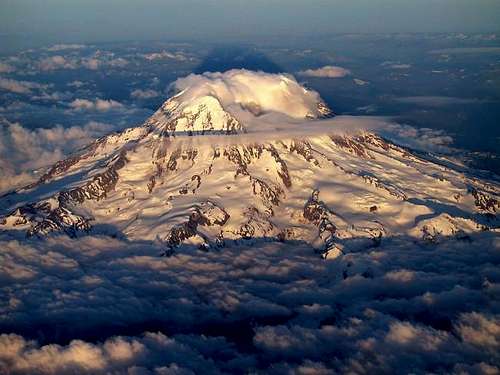 Mt. Rainier from above...You probably can't fly to the trailhead!
Standard Route via Snow Lakes - Class 4 - 5.6
As stated above, start at the Snow Lake Trailhead and hike the nice trail for 1 mile to Snow Lake. If there is a lot of snow, hike southeast across the flat bench for a half mile to Bench Lake and continue through a narrow valley which is fairly obvious to spot at the SE end of the bench. Once through the small valley, emerge at Snow Lake. In summer, the bench is vibrant and filled with beautiful wild flowers offering a worthy hike in itself although don't expect solitude!
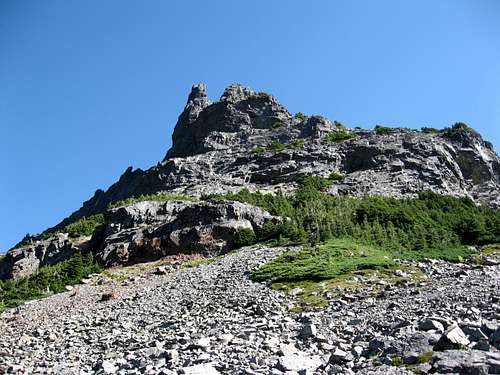
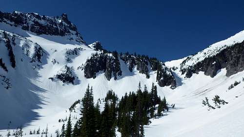
Continue along the west side of Snow Lake on a good climbers trail and go up a steep chute. There will me much talus in summer but good snow in spring. This chute is key to the route...do not be tempted to climb one of the steep head walls to the left. Follow the chute for about 1/2 mile up a 40 degree slope into a large bowl on the northwest side of the peak above treeline. You will now be able to see the daunting north face of Unicorn Peak but rest assured, you won't be climbing it. It also becomes obvious as to why it called "Unicorn Peak"
Continue up the bowl and aim for the saddle on the west side of the mountain. This ascent is an enjoyable climb in firm snow but a miserable scree fest in mid-summer. From the saddle, turn left (east) up a short, steep step and continue hiking eastward just south of the broad ridge crest to the top of the dome. Traverse behind this slightly shorter sub-summit and approach the summit pinnacle from the south side. The pinnacle can be climbed via a number of different routes ranging from Class 4 to Class 5.6.
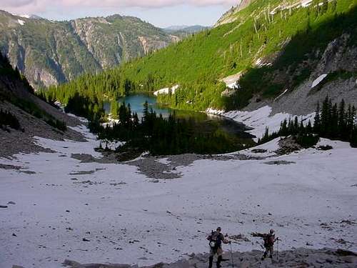 Snow Lake from base of the chute Snow Lake from base of the chute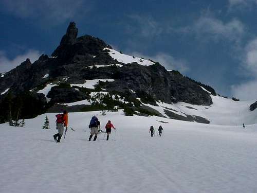 Climbing to the saddle (right side of photo) Climbing to the saddle (right side of photo) |
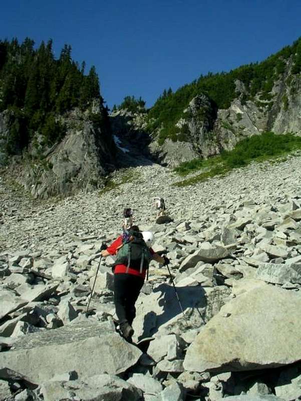 End of the Snow Lake trail and the base of the chute End of the Snow Lake trail and the base of the chute |
 Unicorn Peak from the upper bowl Unicorn Peak from the upper bowl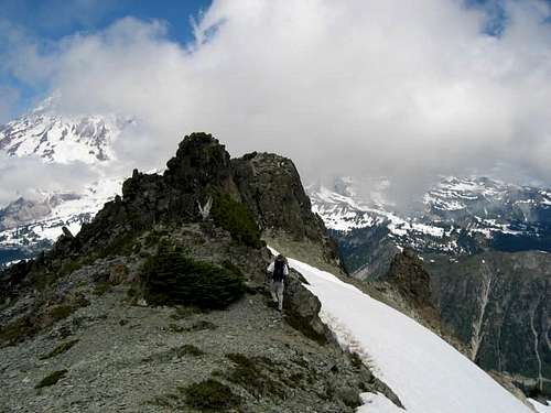 Approaching the base of summit pinnacle Approaching the base of summit pinnacle |
 The Unicorn on the left and the chute in the middle right The Unicorn on the left and the chute in the middle right |
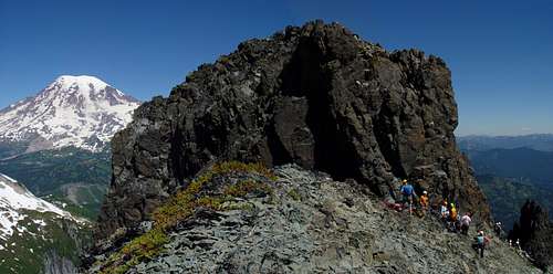 The summit block with Rainier The summit block with Rainier |
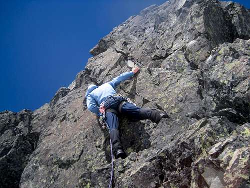
Summit Block
Described below are a few options one has to climb the summit block. They are all fun climbs and each offers a unique challenge. Choose your route based on the comfort level of your group and by the gear you brought on the climb. Each route is 40-50 feet long so a 30 meter rope is enough to both climb any of these routes and make the 50 foot rappel back down. A small rack of cams from 0.3"-1" and a set of stoppers will be plenty for each of these routes. Once everyone in your group reaches the gnarled tree belay, it's a 10 second walk to the summit. Don't forget to peer down the north face while you're up there and admire the fantastic view of Mount Rainier.
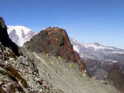 Routes on the Unicorn Summit Pinnacle ('XX' are anchors)
| Route | Photo | Name | Rating | Brief Description |
| 1 |
 |
The Roof | Class 5.6 | Start at the base of the summit pinnacle where it meets the saddle on the South side and climb a finger crack 5 feet to a chimney. Climb into the chimney and up a couple feet until you reach the roof. Then climb to the right out onto a slab and around the right side of a bulge. Walk up to the belay station at the gnarled tree with many slings around it. |
| 2 |
 |
Classic Route | Class 5.6 | Start 20 feet to the right of The Roof and climb easy cracks and ledges up and leftward. Continue climbing diagonally to the gnarled tree and belay. |
| 3 |
 |
Open Book Cracks | Class 5.0 | From the base of The Roof, walk down and East about 30 yards to a shallow gully composed of a couple left leaning cracks. Climb up a couple of moves and scramble to a large ledge. From here, you can see back down the easy walk up variation. Above you will be two parallel cracks leading the rest of the way up. I recommend the crack on the left as the right crack has a slightly overhanging start. Continue up the crack to the top and walk over to the gnarled tree belay station. |
| 4 |
 |
East Side Walk Up Route | Class 4 | Walk past the start of route #3 toward a gendarme east of the summit pinnacle to a dead tree at the base of the summit pinnacle. From the tree, you can walk up a gravelly runnel to a platform below the parallel cracks on the upper section of route 3 (Class 3). From here, either climb the left crack as per route 3 above (Class 5.0) or traverse further right towards the widly exposed north face and continue up an exposed 4th class chimney to the summit. |
Descent
The gnarled tree used for the belay is the rappel anchor. Using a 30 meter rope, make a single rope rappel down the south side of the summit pinnacle and return the way you came.
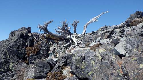 The gnarled tree anchor just below the summit
Camping/Red Tape
A $15 enterance fee or park pass is required to enter Mt. Rainier National Park. Once inside the park, you do not need to pay to climb the Unicorn. Camping in Mt. Rainier National Park is regulated by the National Park Service. There are many campgrounds within park boundaries - some pay, some free. There are also limited backcountry camping permits available.
Wilderness Camping:
The most convenient place to camp is at the Snow Lake camp. This campground consists of two primitive campsites located near the outlet on the North end of Snow Lake. These sites share a pit toilet and a bear pole. If the Snow Lake camp is booked, there are a handful of other trailside campgrounds in the area. You can also obtain a permit for backcountry and alpine camping. Permits for all wilderness camping are free and can be obtained at any ranger station during the summer. During the winter, the Longmire Museum is the only place open and they will set you up with a permit.
Car Camping:
Mount Rainier National Park has 6 car-camping areas with a total of 600 sites that are open during the summer months. Sunshine Point campground is the only car-campground open year round. Fees to use these facilities are from $9 to $15 per night.
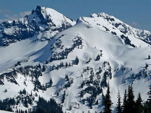 Unicorn Peak from Alta Vista
When To Climb
The Unicorn can be climbed nearly anytime throughout the year. However, the early season climbing is remarkable and provides easy access to the upper mountain via a few steep snowfields (much easier than the scree-slogging alternative). By mid-summer, most of the snow has melted out and you'll be in for a couple of miles of picking your way up talus and bolder covered slopes. During winter months, backcountry skiers and snowboarders will really enjoy the snow filled bowls on the north side of the peak.
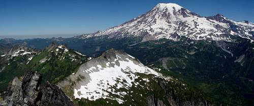
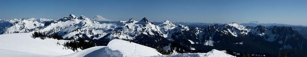 Tatoosh Panorama from Paradise with Unicorn Peak being the highest peak just left of Mount Adams
Map
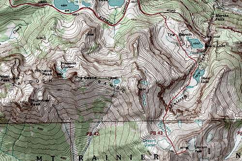 Unicorn Peak map showing the Snow Lake route across The Bench
Note that there is a 2.5 mile one-way road walk from the Narada Falls pullout when the Steven's Canyon Road is still closed. This is shown by the red line at the north end of the map. If the road is open, simply start at the trailhead.
Mountain Conditions
More information on climbing conditions and regulations can be gathered from the Mount Rainier National Park headquarters at Rainier National Park Website or by calling 360-569-2211, extension 2314. Current weather forcasts can be found at The Weather Channel
See this page for good webcams of the Mount Rainier area!
 Tatoosh Webcam
Summit Views
 Mount Rainier from the summit Mount Rainier from the summit |
 Beautiful summit view Beautiful summit view |
Tatoosh Traverse Variation
A popular route variation is to combine Unicorn Peak with several others in the Tatoosh Range and do a traverse. Experienced hikers will be able to bag Stevens Peak, Unicorn Peak, Castle Peak, Pinnacle Peak, Plummer Peak and Eagle Peak in one long day. Click here for more information on the Tatoosh Traverse.
Klenke - Oct 28, 2006 4:27 am - Voted 10/10
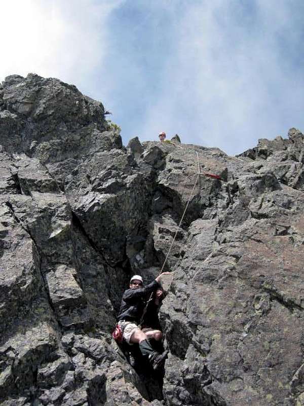
Another route right of #4?Your route annotated as #4 in this pic is correct in so much as it is an easy Class 3 approach to the Class 5.0 route. But I think the easiest route (one easier than Class 5.0) deserves some mention. I elaborate on it in the caption of this picture. This east side route is merely Class 4 (but quite exposed to the North Face). I was able to free-solo it, but not without some initial hesitation.
cluck - Nov 5, 2006 7:59 pm - Hasn't voted
Re: Another route right of #4?Did you down solo the route too? Certainly would be great if there was a reasonable way to get up and down this thing without harnesses and ropes, particularly for parties doing a Tattosh traverse. When my climbing partner and I did the complete traverse (- Stevens) in a day, we carried a rope and only used it for the rap off Unicorn. Would have been nice to ditch a few unnecessary lbs. Thanks for the pic and the beta.
Klenke - Nov 7, 2006 9:03 pm - Voted 10/10
Re: Another route right of #4?I soloed the route, essentially doing the same thing as Eric Hoffman. I carried a 50m rope because he said one might be better. But I learned a 30m would do fine to get off of the south side of the summit. I had plenty of rope to spare (see this pic). I would not like to downclimb the way I went up the east side. It's got some wobble-knee exposure to the north face that would make a mountain goat cry.
Mollymawk - Jul 21, 2015 7:47 pm - Hasn't voted
Notes on summer approach1. On reaching the upper lip of the gully, turn East (left) to ascend the heather slopes & find the well-defined climbers' trail. 2. Stay on the trail close to the rock to avoid the worst of the scree slopes. 3. There is easy 3rd-class scrambling to avoid the steep snow in the saddle.