
|
|
Mountain/Rock |
|---|---|
|
|
46.42112°N / 13.68008°E |
|
|
Hiking, Mountaineering, Sport Climbing, Ice Climbing, Big Wall, Via Ferrata, Skiing |
|
|
Spring, Summer, Fall |
|
|
8678 ft / 2645 m |
|
|
Intro
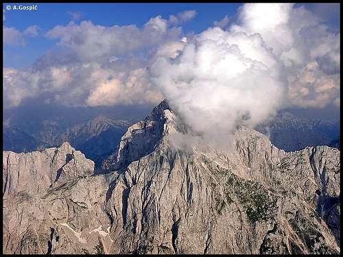
Jalovec is one of the elite peaks of Julian Alps! It belongs among highest of them but in the ‘beauty scale’ it holds, by some, undisputed 1st place. Because of its legendary shape, which shows above Tamar valley, Jalovec is also known as Crystal Mountain. Matterhorn of Slovenia is ever present in books, posters or postcards. Its silhouette proudly decorates the logo of Slovenian Mountaineering Association. To be selected by Slovenians before King Triglav is most powerful admission there can be!
 |
 |
 |
 |
 |
 |
Crystal called Jalovec
Jalovec (2645m)
Legendary panorama of Jalovec from Sleme
Jalovec towers high above 3 valleys that surround it; from 1540m above Planica, 1700m above Trenta to around 2000m above Koritnica! It is also much higher than ridges which lead to it so it offers fantastic panoramas in all directions. In geography section is a description of closer surroundings. Wider panorama includes a large part of the eastern Alps including long crest of Hohe Tauern in Austria on the north, with its highest peak Grossglockner (3798m) and Grossvenediger (3666m). On the west is Italy and Dolomites with Marmolada (3342m).
First on the summit stood Karl Wurmb and two guides, Crnuta and Strgulc, in 1875. They climbed from Koritnica valley. First climb from Trenta valley did Karl Blodig in 1878. Famous explorer of Julian Alps, Julius Kugy and guide Andrej Komac were first to summit from Planica valley, in 1884. First to climb NE face of Jalovec was Ferdinand Horn in 1909.
Today Jalovec is one of mostly climbed of high Slovenian peaks! Don’t let that fact fool you, it is ‘tough’ mountain. At your disposal are two objects. In NE foothills is Tamar hut while on the southern slopes is Zavetisce pod Spicko refuge. Trails climb Jalovec from north, south and west with few sub variations. All climbs are long, none being shorter than 5 hours and all of the routes contain rock climbing sections.
The easiest of them is southern route from Vrsic pass or Trenta valley. Above Zavetisce pod Spicko refuge route has climbing character, firstly through the cliffs of Veliki Ozebnik (2480m) and then Jalovec summit climb. Northern route from Tamar valley has 2 variations and 1 sub variation. One route leads through dark, narrow and deep couloir Jalovcev Ozebnik and is dangerous because of rockfall but very attractive. Inside the couloir snow and ice are ever present so crampons are a must. Sub variation of this route avoids couloir but contains some exposed climbing. This sub variation joins couloir route and southern route at the foothills of summit climb.
The second route is Tamar route via northern shoulder, also a ferrata and most attractive of routes. Tamar valley trails are only for experienced mountaineers. There is also western route from Koritnica valley which is least popular. This route joins Tamar route via northern shoulder on Kotovo Sedlo pass and also contains some secured sections till this point. Further up is ferrata. Jalovec is also popular among climbers because of its nice NW face and Horn route.
 |
 |
 |
 |
 |
 |
Geography around Jalovec and Closer Views
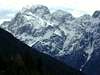
 Jalovec from Mojstrovka
On the NE, some 1540m lower, is Planica valley. Above it Jalovec shows its most beautiful side which has a shape of a huge crystal. Upper end of Planica valley is Tamar where Tamar hut stands (1108m) which offers fantastic view of Jalovec. From here to the summit leads a classic route that has two variations: via Jalovec couloir or via Kotovo Sedlo pass and northern shoulder.
On the N is Kotovo Sedlo (2134m) pass, which divides Jalovec from the sharp ridge of Ponce group.
On the W, some 2000m below, is Koritnica valley with Log pod Mangartom (651m) village. This is the most powerful side of Jalovec, 2000m high, consisting mostly of cliffs. Across the valley, around 2.5km in NW direction, stands mighty Mangart (2678m). Its 2000m high southern face and slopes are most beautifully seen from Jalovec. Just left of Mangart, behind from here lowly Predel pass (1156m), rises Vis (2666m) & Montaz (2754m) group of Julian Alps which is in Italy.
Towards SW is a mighty ridge, with its highest peak Briceljk (2346m), which divides Koritnica from Bala valley. Above Koritnica this ridges falls with one of the most powerful walls in Slovenia, Loska Stena face, which is over 1000m high.
Towards S first neighbor of Jalovec is sharp Veliki Ozebnik (2480m). Above Trenta valley it shows its most beautiful side and looks like a smaller brother of Jalovec. Together they form one of most beautiful and most frequently photographed panoramas in the Julian Alps. Near its southern foothills stands Zavetisce pod Spicko (2064m) refuge over which lead towards Jalovec Vrsic pass and Trenta valley routes. Further towards the south of Veliki Ozebnik ridge continues till mighty Bavski Grintavec (2347m). The most eminent peak in between is Pelc nad Klonicami (2442m).
On the SE & E, some 1700m lower, is beautiful Zgornja Trenta (upper Trenta) valley. Just a few minutes above the trailhead of the Trenta route towards Jalovec is the typical karst source of the Soca river. It appears on the surface coming out of deep hole filled with crystal clear blue water, surrounded by smooth and dark cliffs. Towards SE, across the valley, is long, wild and sharp ridge with its highest peak Trentski Pelc (2109m). Towards E, also across the Trenta valley, lined up from left are Prisojnik (2547m), Triglav (2864m) and Kanjavec (2568m).
On the NE, closing Planica valley with over 1000m high face from the north, is long Travnik (2379m) - Mojstrovka (2366m) ridge.
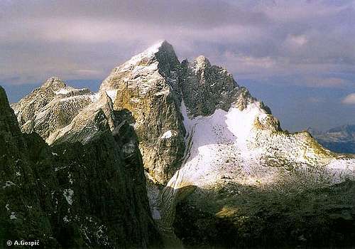
 Jalovec from Mangart
 |
 |
 |
 |
 |
Valleys
Planica is first, 5km long, side valley of Zgornja Savska Dolina (upper Sava river valley), which makes the northern border of Slovenian Julian Alps. From north Planica cuts deep into Jalovec group. At its mouth or end is Ratece village (870m) and one of two sources of 1000km long Sava river. Sides of the valley rise steeply. On the west (right) is sharp and wild ridge of Ponce group with Velika Ponca (2274m), its highest peak. On the east (left) is Ciprnik (1746m). At the end of the valley is the mighty north wall of long Travnik (2379m) - Mojstrovka (2366m) ridge. 6km from the entrance in the upper 2km long part of the valley called Tamar stands Tamar hut (1108m). Travnik – Mojstrovka wall, which is 1000m high, towers just above but what draws one’s attention is magnificent Jalovec panorama.
From here it shows its most beautiful face of a crystal. From the hut valley slightly changes direction towards SW as it gets narrower and ascends ever steeply when it turns into scree slopes which finally end as deep and dark couloir Jalovcev Ozebnik, squeezed between cliffs of Jalovec and Golicica. Planica is also very popular among climbers, especially very demanding wall of Mojstrovka. Tour ski route from Kotovo Sedlo pass is also very popular. Planica is best known because of Ski jumping and flying where current world record is set. First man flew over 100m here. It was Sepp Bradl in 1936. Also first jump above 200m happened here. Every March final event of World Cup competition is held here.
Trenta is by many most beautiful and most romantic valley of Julian Alps. It is certainly one of the longest (around 22km), placed in the heart of Julian Alps, dividing them into the western and eastern part. Its mouth or end is near the small town of Bovec where it enters Bovec basin. Through it runs the most beautiful Slovenian river, crystal clear Soca! It has an amazing light blue – light green color and is very popular for rafting. Along the river there are a few villages and hamlets. The largest and most beautiful villages are Soca and Trenta. Trenta is a very deep valley. Some of the peaks rise 2000m above it! Trenta begins below the beautiful Bavski Grintavec (2347m). Its 5km long upper part, squeezed between Jalovec group and Trentski Pelc ridge, is called Zadnja Trenta.
This is the wildest and most beautiful part of the valley. At the end of Zadnja Trenta, where the valley begins to make 180 degree turn around Trentski pelc group is the source of Soca river. It appears on the surface 100 meters above the valley floor, coming out of deep hole filled with crystal clear blue water, surrounded by smooth and dark cliffs. A kilometer lower, at the bridge over Soca and Limarica rivers, Vrsic pass road begins to ascend. A few hundred meters up the road is the famous monument to Julius Kugy which as ever looking at Jalovec. This is one of the most beautiful panoramas in the Julian Alps!
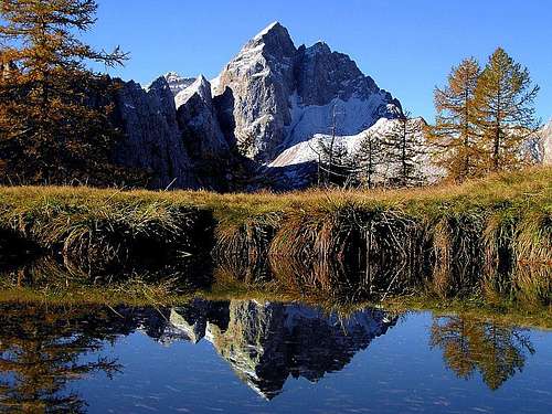
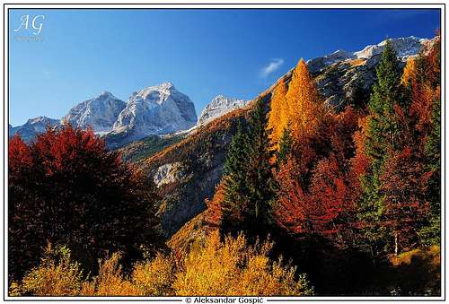 Autumn in Trenta Valley
Koritnica is the northern tributary to the Soca river and most significant in its upper part. The end of Koritnica valley is near the small town of Bovec where it enters the Bovec basin and runs into the Soca river. Koritnica valley is dark, deep and narrow. Two kilometers before the end of the valley, at Kluze fort, is the famous Koritnica gorge, which is only a few meters wide but over 50m deep, it is an amazing place. In the upper part of 12km long the valley is nice village Log pod Mangartom (650m). As the name says it is placed below mighty Mangart (2678m). Opposite of Mangart is also equally impressive Jalovec (2645m). Both mountains rise 2000m above the valley and make perfect panorama! Just above the village is beautiful Loska Stena face, few kilometers wide and 1000m high.
 |
 |
 |
 |
 |
Hike Advice
Tamar trailhead:
- climb Jalovec via Kotovo Sedlo and northern shoulder, descent via Jalovcev Ozebnik couloir. This is a better combination than vice versa.
- climb Jalovec (5-6h) and descent to Zavetisce pod Spicko refuge (2.30h). Sleep over and continue the next day towards Vrsic (4h). From Vrsic return to Tamar via Sleme (3h). This beautiful circle can be done in a day but it’s very tough and long.
Vrsic trailhead:
- reach Zavetisce pod Spicko refuge during the day (4h). Sleep over and climb Jalovec in the morning (2.30-3h). You can do this in a day also if fit.
- same to the summit. From summit descent to Tamar hut (4.30h) and climb back to Vrsic pass via Sleme (3.30h)
Koritnica valley route can’t be combined with other routes because trailhead is very far from Tamar or Vrsic.
 |
 |
 |
 |
Getting There
Routes climb from 3 different valleys and a pass. How to reach them is described in each route section.
The heart of the region is Kranjska Gora resort town, 84 kilometers from the Slovenian capital Ljubljana.
by Plane
If you want to reach Ljubljana by plane check a timetable on the site of Adria Airways, a national airline.
by Bus
From Ljubljana buses depart towards Kranjska Gora every 60 minutes.
by Train
From Ljubljana trains depart in Kranjska Gora direction quite often but only up to Jesenice town. There you have to change to bus, which comes from Ljubljana anyway. Jesenice are also on the main railway from Ljubljana towards Austria and Germany so it can be reached by train from Western Europe.
Slovenian railways
German railways
by Car
From Ljubljana: 84km
From central Europe via Villach, Austria:
Villach – Kranjska Gora via Karavanke tunnel: 40km
Villach – Kranjska Gora via Korensko Sedlo pass: 30km
From western Europe via Udine, Italy: exit Udine – Villach highway in Tarvisio. Tarvisio – Kranjska Gora 20km.
 |
 |
 |
 |
When to Climb
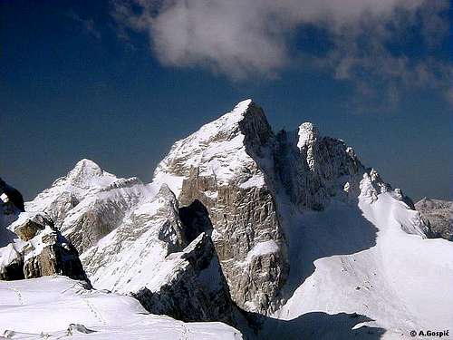
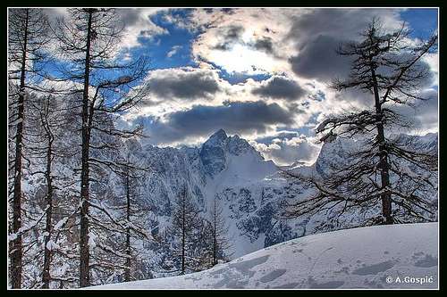 Jalovec in winter from Sleme
November – June is a snowy period on Jalovec. During that period full equipment is needed including a lot of experience. Pegs and fixed ropes are under snow and all that remains are very steep snowy or icy slopes with bare cliffs sections which are to steep for snow to hold. Tamar route via Kotovo Sedlo pass and northern shoulder is out of question except for experts. Tamar route via couloir is practically the same all the time because it is under snow the whole year. That route has the least cliffs sections but the danger of avalanches in couloir is huge. The best route in the snowy period is the southern route via Zavetisce pod Spicko refuge. Have in mind that last 650 altitude meters above refuge are climbing steep cliffs. It is very likely that this section will be free of snow in June already.
July – October is best period to climb Jalovec for those that don’t like snow fun. In June it is not cold anymore but there can be quite a lot of steep snowfields on the routes and soft snow where exposed to sun. Trails are quite busy in summer, especially Vrsic pass route, which is quite hot. Most pleasant summer route would be through couloir, which is in deep shade. Even in summer crampons are necessary here.
 |
 |
 |
 |
Mountain Conditions
Mountain conditions in Julian Alps are well-known thanks to Kredarica (2515m) hut and metro station, which is just below the Triglav.
Best overview of daily data values is provided by Russian Weather Server -> Kredarica @ Infospace.ru
You can also observe current conditions and forecast for Kredarica on the Wunderground metro site.
Wunderground - Kredarica page
Current weather and forecasts can also be found on the Slovenian Environment Agency pages.
Direct link to Current Conditions page
Direct link to Snow Depth page
Huts by the Routes
Dom v Tamarju (1108m) hut stands on the edge of a picturesque meadow, in Tamar, which is the upper part of Planica valley. The hut was built in 1899 and since then numerous times rebuilt and renewed, last time in 1984. From here is beautiful view on the towering peaks around, north wall of Mojstrovka and especially Jalovec. This is one of the most romantic spots in the Julian Alps. It has 128 beds, hot water, electricity, phone etc. and it's open ALL YEAR. Tamar hut is accessible by car from Ratece (6km).
Zavetisce pod Spicko (2064m) refuge stands on the scree slopes just bellow Spicek, isolated needle and high above Trenta valley. First refuge was placed here in 1935. Today it has 30 sleeping places and it is supplied in summer. In winter there is winter room available. From the hut is amazing view towards east and peaks on the other side of Trenta valley: Prisojnik, Razor, Triglav and Kanjavec.
Koca pri izviru Soce (866m) hut stands in Zadnja Trenta (upper trenta) valley, two kilometers from the junction on the Vrsic pass road. 10 minutes above the hut is source of Soca river. Since this is not very popular Jalovec trailhead it is more a restaurant than hut. It has 44 beds, electricity and is open from April to October.
Mihov Doma na Vrsicu (1085m) hut is standing just above the Vrsic road, 6 kilometers both from Kranjska Gora and Vrsic pass. The house was built after WW I and used by Yugoslav army. After the WW II Kranjska Gora mountaineering club bought it and opened it in 1948. Since then it was renewed a few times, last in 1987. It has 22 beds, hot water, electricity, phone etc. It is open ALL YEAR.
Koca na Gozdut (1226m) hut is standing just by the Vrsic road, 8 kilometers from Kranjska Gora and 4 kilometers from Vrsic. First house standing here has been built in WW I for the workers of Vrsic road. After the war mountaineering club from Kranjska Gora bought it and opened it in summer of 1922. Hut had to be closed in 1979 because of bad conditions. In the summer of 1984 the construction of new hut begun and it was opened in 1986. It has 43 beds. Each room has its own bathroom. It is open ALL YEAR.
Erjavceva Koca na Vrsicu (1525m) hut is standing on top of small head, surrounded by larch trees, just by the road, some hundred vertical meters or 1 kilometer in distance bellow the Vrsic pass on the north side. From the hut is beautiful view on the towering Prisojnik (2547m). First hut was built here in 1901. In 1987 it has been decided that old hut is in bad condition and no longer usable, has to be demolished and new one build, at the same spot. New hut was opened in 1991. It has 94 beds, hot water, electricity, phone etc. It is open ALL YEAR.
Ticarjev Dom na Vrsicu (1620m) hut is standing on the southern side of Vrsic pass, just by the road. First hut here was opened in 1912 and was named Slovenska Koca (Slovenian Hut). Between 1964 and 1966 a new hut has been built, just by the old one, which was demolished upon finishing the new one. In April of 1975 huge avalanche from Mojstrovka destroyed part of the hut. It has 91 beds, hot water and electricity, phone etc. and is open from May 1st till the end of October.
Postarski Dom na Vrsicu (1688m) hut is the highest standing of 3 Vrsic pass huts and has the most beautiful view. Since it is not accessible by car it remained truly mountaineering hut. It has been built in 1952 on a small terrace bellow the Vrsic peak (1737m), after which pass was named. It has 65 beds, electricity, phone, hot water and its open from June 1st to September 30th. 15 minutes on foot from Vrsic pass.
 |
 |
Camping
Camping inside the National Park is forbidden. Besides the mountain huts there are plenty of hotels and private apartments in the towns and villages, which surround the area. Here are a few links where you can find info on accommodations closer and further away:
Kranjska Gora
Mojstrana
Bovec
Bled
Bohinj
Red Tape
Jalovec and its surroundings is in the Triglav National Park but there is no entrance fee. The only thing you might pay is parking on selected locations.
External Links
- Weather undregruond kredarica
This is weathercast for Triglav and other nearest peaks
Bor - Feb 28, 2005 5:25 am - Voted 10/10
Untitled CommentYou can do some links in the text of Pelc nad Klonicami! ;-)