
|
|
Mountain/Rock |
|---|---|
|
|
39.86440°N / 105.9467°W |
|
|
12804 ft / 3903 m |
|
|
Overview
Byers Peak stands out as a prominent, highly visible mountain to the west of the town of Fraser in southern Grand County, and is an easily identifiable and beautiful landmark. It is also the highest point in the Byers Peak Wilderness Area. Despite having only two main trailheads, there are many routes and loop hikes available. Just one possibility is to combine Byers Peak with Bills Peak. Byers Peak is a very popular peak, but doesn't receive quite as much attention as other (14er) peaks in the area due to its lower height. The summit has excellent views of all the peaks in the Vassquez Moutains, the Never Summer Range, Indian Peaks, Rocky Mountain National Park, Williams Fork Range, and the Gore Range.
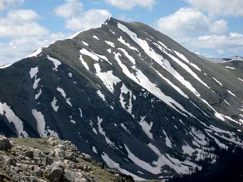 Byers Peak as viewed from Ptarmigan Peak.
Getting There
East versus West Access
The two main access routes to Byers Peak are from the Fraser Experimental Forest on the east and the Keyser Creek Drainage on the west. Each access route offers its own advantages and disadvantages. The East Access is a much shorter drive for those living in the Fraser River Valley or the Front Range. The access road is also better. The West Access definitely offers the more scenic routes for climbing the peak. The trails are also more pleasant and less well used. The disadvantage is that the access road is rougher and it is a longer drive if you are coming from the east (as do most people living in Colorado).
Old (Bottle Pass) and New Byers Peak Trailheads (East Access)
There are a few routes to get to the trailhead, but this one may be best. From Highway 40 at the shopping center near the center of Fraser, turn south on County Road 72 for 0.2 miles. Turn right on Fraser Parkway for 0.8 miles. Turn left on County Road 73 and follow it for 7.0 miles. There are a few side tracks, but stay on the main road. Make a right and follow the road 3.0 miles to the gate and trailhead. The road has a few potholes, but is suitable for two-wheel-drive vehicles.
Keyser Creek Trailhead (West Access)
East of Parshall (not far east of Kremmling) and on Highway 40 between mile post 197 and 198, turn south onto Country Road 3. Follow County Road 3 until you reach County Road 32 (FR-139), mile 12 (formerly between mile markers 15 and 16?) on County Road 3. Follow County Road 32 for 4.7 miles and turn right on FR-136 on the road marked for Lake Evelyn and Bottle Pass Trail. The small parking area at the trailhead is reached after another 3.9 miles. The last road is sometimes rather rough in places, but if you drive slowly, most vehicles can make it.
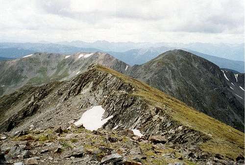
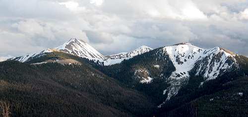 The two lower peaks in the foreground are Bottle Peak (left) and Ptarmigan Peak (right). The two higher peaks in the background are Byers Peak (left) and Bills Peak (right). As seen from Sheep Mountain on June 7 2009.
Routes Overview
For full descriptions, rather than references to other routes/route combinations, please click on the links to the descriptions for each individual routes.
Note: This trail is not the one shown on the topo map. This is a newly constructed trail and has become the standard route on Byers Peak. It is probably the easiest route and there is some easy class 2 scrambling on the last part of the ridge. The summit is 4.4 miles from the trailhead and has 3000 feet altitude gain.
 The New Beyers Peak Trail.
Note: The beginning of this trail is not shown on the topo map. This trail offers a less crowded alternative to the New Byers Peak Trail and makes a nice loop with the New Byers Peak Trail. This route is easy, but requires more navagational skills than the standard route. Much of the trail is pretty faded, but easy to follow as it stays close to the ridgetop. If you plan to ascend one trail, and return via another, it is recommended that you ascendthe Old Byers Peak Trail and decend the New Trail. The reason for this is that its easy to miss the turnoff to the Old Trail while descending because the junction is not marked. The summit via this route is 3.8 miles with 3000 feet elevation gain.
The Keyser Creek route is on the west side of Byers Peak and is less used than the eastern routes. It is also a more scenic route and offers great views of Bills Peak's north face. The total distance from the Keyser Creek Trailhead to the summit is 5.3 miles with 2800 feet elevation gain.
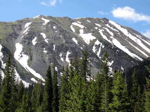 Byers Peak as seen from the Keyser Creek Drainage.
Byers/Bills Peak Loop
There are many spectacular options for a loop hike combining both Byers and Bills Peaks. See two route suggestions below:
Byers/Bills Peak Loop via New Byers Trail
Byers/Bills Peak Loop via Keyser Creek
 Byers-Bills Peak Ridge
Red Tape
No permits are required to climb Byers Peak. Parking at the trailheads is free.
When To Climb
The most popular season is July through September. Expect to walk through some snow at least as late as mid July. Byers Peak would make a fine winter ascent, but you must walk a much longer distance. Beware of thunderstorms in the summer months!
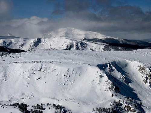 Byers Peak in February
Camping
Camping is available below the Fraser Experimental Forest trailhead at the Byers Creek Campground. Check with the Forest Service (970-498-2770) for the current fees. Because Byers Peak lies within the Fraser Experimental Forest, overnight camping is not allowed except at designated camping areas. For information on current camping restrictions and other camping areas in the vicinity, contact the Sulphur Ranger District. Keyser Creek Drainage (West Access) offers several undeveloped campsites.
Mountain Conditions
Because it stands in relative isolation above the Fraser Valley, Byers Peak experiences frequent and strong winds, even on good-weather days. Be sure to bring a lightweight windbreaker. The section of trail above timberline is short, and can be downclimbed quickly and easily In the case of inclement weather, but it is always wise to watch the skies.
For current road and trail conditions, contact: Sulphur Ranger District 9 Ten Mile Drive Granby, CO 80446 970-887-4100
Below is the climate summary for nearby Berthoud Pass at 11,315 feet elevation. These are all averages, so expect more variation, but this will give you a good idea about the climate at higher elevations around Byers Peak. *National Weather Service Data 1950-1985.
| MONTH | HIGH | LOW | SNOW DEPTH | DAYS W/PRECIP |
| JAN | 21 | 1 | 42" | 19 |
| FEB | 24 | 2 | 52" | 16 |
| MAR | 29 | 6 | 63" | 20 |
| APR | 36 | 14 | 67" | 17 |
| MAY | 45 | 23 | 53" | 16 |
| JUN | 54 | 32 | 17" | 11 |
| JUL | 62 | 39 | 0 | 14 |
| AUG | 60 | 38 | 0 | 14 |
| SEP | 53 | 31 | 0 | 11 |
| OCT | 42 | 21 | 3" | 10 |
| NOV | 30 | 10 | 14" | 15 |
| DEC | 23 | 3 | 29" | 18 |
mttbyers11 - Sep 15, 2015 11:03 am - Voted 9/10
Directions from Keyser CreekI got here very late, in the dark, and the directions were spot on with the exception of the mile markers on County Road 3, for the turn off to FR 139. As of Sep 11, 2015 the turn off to FR 139 was just past mile marker 12, and not between mile markers 15 and 16. Otherwise, everything was spot on. Thanks for the detail!
Scott - Sep 15, 2015 12:39 pm - Hasn't voted
Re: Directions from Keyser CreekThanks. I will fix it. Country roads redo their miles occasionally!