
|
|
Mountain/Rock |
|---|---|
|
|
48.91130°N / 121.0163°W |
|
|
Whatcom |
|
|
Hiking |
|
|
Spring, Summer, Fall |
|
|
6102 ft / 1860 m |
|
|
Overview
Desolation Peak is a famous and popular summit destination located along the eastern shore of Ross Lake in the North Cascades of Washington. Although only a mid-elevation peak, especially in relation many other nearby mountains, Desolation Peak is one of the most prominent peaks in Washington and offers some of the best views of the North Cascades from a single location.
 Desolation Peak
Desolation Peak is famous because of two main reasons: A fire lookout and Jack Kerouac. The Desolation Peak Lookout was built in 1932. It is an L-4 ground cabin that, until recently, was regularly staffed during Summer months. The fire lookout is not decommissioned and is occasionally still used, but public access is not allowed. The building is listed on the National Historic Lookout Register. The Desolation Peak Lookout, and Desolation Peak itself, has gained much attention and fame because of novelist/poet Jack Kerouac.
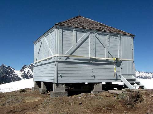 Desolation Peak Lookout
Kerouac was a writer during the mid-1900s who is generally considered the father of the "Beat" movement (although he disliked such labels). During the mid-1950s, he became inspired from accounts by two of his idols, Gary Snyder and Philip Whalen, each of whom had stayed at fire lookouts for their own self enlightenment. In 1956, Kerouac followed his idols' example and took a Summer job at Desolation Peak Lookout. His experiences at the lookout inspired his novel Desolation Angels, the opening section of which was nearly word-for-word from the personal journal he kept while staying at Desolation Peak Lookout. The novel reveals Kerouac's personal struggles with himself, his beliefs, and his past, during such moments as waking up every morning on Desolation Peak to the sight of nearby Hozomeen Mountain or questioning Buddhist philosophy that he had once admired. Desolation Angels was published in 1965, has since become a cult classic novel, and is perhaps the most famous reason why Desolation Peak has since become a popular summit destination.
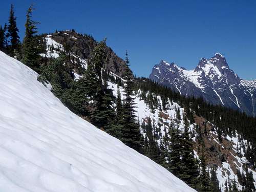 Desolation Peak Summit With Hozomeen Mountain In Background...
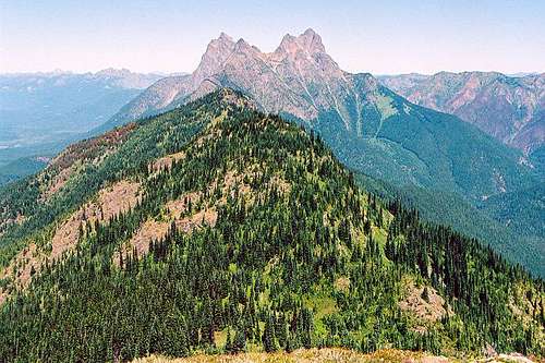
Desolation Peak is also an important mountain for many peakbaggers. With 3249' of prominence, Desolation Peak is the 43rd-most prominent peak in Washington. The summit offers a 360° panoramic viewpoint, including views of other nearby peaks that also have over 2000' of prominence each. Those peaks include Hozomeen Mountain, Jack Mountain, Mount Prophet, Mount Spickard, Luna Peak, Ruby Mountain, Castle Peak, Three Fools Peak, "Daemon Peak", Buckner Mountain, Snowfield Peak, Eldorado Peak, Goode Mountain, Mount Baker, and Mount Shuksan. The mountain also provides great views towards the North Cascades (including the Picket Range), Pasayten Wilderness, and peaks in British Columbia.
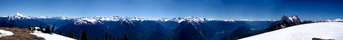 Panoramic View From Desolation Peak Summit
Getting There
Primary access to Desolation Peak originates south of the mountain, either via boat or trail to the Desolation Peak Trail.
IF HIKING THE ENTIRE DISTANCE TO DESOLATION PEAK TRAIL (FROM SOUTH):
1) Drive along Highway 20 to the East Bank Trailhead, located near Milepost 138 on the north side of the highway.
2) Hike north along the East Bank Trail for 16.0 miles to Lightning Creek Camps. The Desolation Peak Trailhead originates at the campsite.
------------
IF USING A BOAT TO ACCESS DESOLATION PEAK TRAIL (FROM SOUTH):
OPTION #1: Bring Your Own Small Boat, Canoe, or Kayak
1) Drive along Highway 20 to Colonial Creek Campground. A boat ramp into Thunder Arm/Diablo Lake is available at that location.
2) Boat, canoe, or kayak north and then east on Diablo Lake for 5.0 miles, until near the Ross Lake Dam at the end of the lake.
3) To get by Ross Lake Dam, portage all craft (i.e. boat, canoe, kayak) and gear for one mile (with 520' elevation gain / 120' elevation loss) along a switchbacked gravel road to its end at a boat dock on the southwest shore of Ross Lake.
4) Boat, canoe, or kayak north on Ross Lake for 12.0 miles to Lightning Creek Camps, or 14.1 miles to the Desolation Peak boat dock.
OPTION #2: Take the Ross Lake Water Taxi
1) Drive along Highway 20 until reaching the Ross Lake Dam Trailhead near Milepost 134.
2) Hike north along the Ross Lake Dam Trail for 0.8 miles, until reaching a gravel road. Turn right (east) onto the gravel road.
3) Follow the gravel road for approximately 0.45 miles, until reaching the end of the road at a boat dock.
4) There is a phone approximately 0.1 miles from the end of the road. Use the phone to contact Ross Lake Resort for pick-up. The pick-up ride to the resort only takes a few minutes, but costs $2.00 per person.
5) When at the resort, take the Ross Lake Water Taxi either to the Lightning Creek Camps or Desolation Peak boat dock.
*** NOTE: There is a significant cost for this option. As of Summer 2010, the cost of the Ross Lake Water Taxi was $100 ONE-WAY to Lightning Creek Camps and $110 ONE-WAY to the Desolation Peak boat dock. Advanced reservations are required, and each water taxi can only accommodate six passengers. Contact Ross Lake Resort at (206)386-4437 in advance of a trip, for updated pricing and/or to make water taxi reservations. ***
OPTION #3: Rent A Boat, Canoe, Or Kayak From Ross Lake Resort
1) Drive along Highway 20 until reaching the Ross Lake Dam Trailhead near Milepost 134.
2) Hike north along the Ross Lake Dam Trail for 0.8 miles, until reaching a gravel road. Turn right (east) onto the gravel road.
3) Follow the gravel road for approximately 0.45 miles, until reaching the end of the road at a boat dock.
4) There is a phone approximately 0.1 miles from the end of the road. Use the phone to contact Ross Lake Resort for pick-up. The pick-up ride to the resort only takes a few minutes, but costs $2.00 per person.
5) When at the resort, rent a boat, canoe, or kayak. Each boat is an 14' vessel that can (in theory) hold up to five people without any gear. With gear (such as backpacks) included, the maximum number of people per boat should be four, and some who have done that might even suggest the maximum number of people per boat to be three or less to minimize extra boating time and fuel usage.
6) Boat, canoe, or kayak north on Ross Lake for 12.0 miles to Lightning Creek Camps, or 14.1 miles to the Desolation Peak boat dock (or the rocky beach a short distance south of that point).
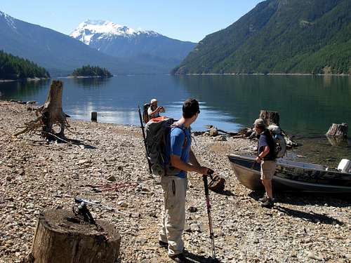 Arriving At Rocky Beach South Of Desolation Peak Boat Dock...
*** NOTE: Advanced reservations are highly advised, especially if planning a trip after fishing season on Ross Lake begins in July. As of Summer 2010, each boat rental cost $95 plus tax, each canoe rental cost $30 plus tax, and each kayak rental cost $40-$55 plus tax. It is possible that rental prices might be slightly less during June, before the main fishing and boating season starts. Contact Ross Lake Resort at (206)386-4437 in advance of a trip, for updated pricing and/or to make rental reservations. ***
------------
Access to Desolation Peak is also available via a North Route.
Desolation Peak Trail
The official trailhead (~1600' elevation) for Desolation Peak Trail begins at Lightning Creek Camps, on the east side of Ross Lake, at the trail's junction with the Lightning Creek Trail and East Bank Trail.
1) Hike north on Desolation Peak Trail, along the east side of Ross Lake/ southwestern embankment of Desolation Peak.
2) After 2.1 miles, the trail begins heading east and up the western slopes of Desolation Peak.
*** NOTE: If accessing Desolation Peak via boat as a one-day trip, the first 2.1 miles can be avoided by using a small boat dock, or a small rocky beach a short distance south of that point if the dock is not accessible, located north of Cat Island, where the trail heads east and uphill. ***
3) From the point (or boat dock) where the trail heads east, hike the Desolation Peak Trail for 3.7 miles from that location through thick forests to the ridgetop of the mountain. Desolation Camp (~5200' elevation) is located where the trail reaches the ridge.
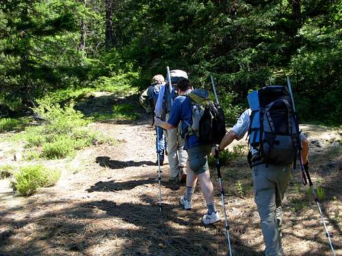 Hiking Desolation Peak Trail...
4) Once on the ridge, follow the trail north across subalpine meadows for one mile to the summit (6102' elevation).
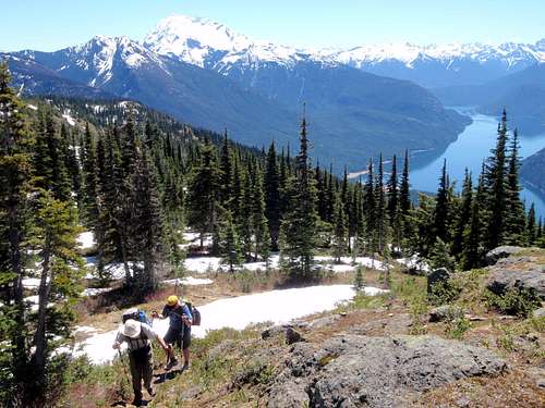 Ascending Summit Ridge...
HIKING DISTANCE: 6.8 miles one-way if starting at Lightning Creek Camps, or 4.7 miles one-way if starting at the Desolation Peak boat dock, with 4500' elevation gain.
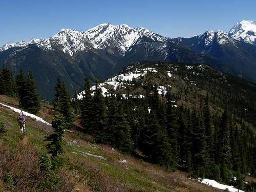 Descending Summit Ridge...
Camping
Camping rules for Desolation Peak are overseen and administered by North Cascades National Park. A backcountry permit is required for all overnight stays at all of the nearest campsites. Backcountry permits are limited, so it is highly recommended to make reservations in advance.
DESOLATION CAMP:
Although a fire lookout is located on the summit of Desolation Peak, no camping or overnight stay is actually allowed at the summit. Camping is only allowed at established/designated campgrounds. The nearest such campsite is Desolation Camp, which is located one mile south of the summit where the Desolation Peak Trail reaches the peak ridgetop. Desolation Camp only has enough room for one camping group, with a maximum of eight people within the group.
No water sources are located at Desolation Camp or along the Desolation Peak Trail.
No campfires are allowed at Desolation Camp.
At least one bear canister is required for any group staying at Desolation Camp.
------
The next closest campsites are the following options:
LIGHTNING CREEK CAMPS:
Located at the trailhead for the Desolation Peak Trail, 6.8 trail miles south of the summit. Five campsites are available for hikers, and two campsites are available for stock.
LODGEPOLE CAMP:
Located along the East Bank Trail, 0.7 miles south of Lightning Creek Camps and 7.5 trail miles south of the summit. Three campsites are available for hikers.
CAT ISLAND CAMP:
Located on Ross Lake, southwest of Desolation Peak. Four campsites are available, but can only be accessed via boat.
WILLOW LAKE CAMP:
Located at tiny Willow Lake on the north base of Desolation Peak. This is the nearest campsite if attempting Desolation Peak from its north ridge.
Red Tape
-> Camping is only allowed at designated campsites, and only with a backcountry permit. See "Camping" section.
-> The Desolation Peak Trail is considered a "dry trail". Once beyond Ross Lake, there are no water sources on the peak. The only exception would be if snowpack is on the summit ridge.
-> There is a lot of sensitive species of flora on the mountain. Use consideration and caution when taking breaks, and try to only rest on rocks or the trail itself rather than destroying surrounding vegetation.
When To Climb
This peak is most recommended for attempts during periods of little-to-no snowpack. That occurs between mid-June through mid-October during most years.
If renting a boat, canoe, or kayak from Ross Lake Resort, it might be best to attempt the peak during mid-to-late June, before fishing season on Ross Lake begins. This will help raise the possibility of finding an available boat/canoe/kayak rental, and possibly also have a lesser rental cost.