
|
|
Mountain/Rock |
|---|---|
|
|
40.26560°N / 105.6205°W |
|
|
Larimer |
|
|
Hiking, Scrambling |
|
|
13326 ft / 4062 m |
|
|
Overview

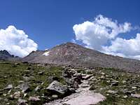
Storm Peak as seen from the Keyhole
Technically speaking, Storm Peak isn’t even a ranked point. By Colorado standards, it falls well below the minimum 300’ prominence and 1 mile isolation rule (generally accepted and agreed upon perimeters). Even standing at the Boulderfield, a flat, rocky plateau that separates Lady Washington, Longs Peak and Storm Peak, the summit only rises an additional 570’ above to the west. What makes Storm Peak a good destination is that it serves as an excellent end-of-the-day scramble after doing say, Longs Peak or when combined with Mt. Lady Washington.
Longs Peak is the center (nexus) of four radiating ridges. The southwest ridge terminates at the equally lofty Mt. Meeker (a worthy scramble in its own right) and the southwest ends at Pagoda Peak. Lady Washington brings up the northeast and Strom Peak resides on the northwest ridge. If someone would come up and tell me that Storm Peak isn’t a ‘real’ summit, that it’s nothing more than a bump along the ridge extending from the Keyhole, honestly, it would be hard for me to argue it. Though, it is a named point and recognized by RMNP and the general consensus is that most people treat it as a separate peak…hence this SP page.
Storm Peak is an easy mountain. Considering a good, well-maintained class-1 trail exists to within a quarter mile of its summit followed by an easy class-2 scramble, Storm Peak is what we like to call, “low hanging fruit.” The mountain and nearby Storm Pass were probably named by Enos Mills because of the tendency of storms and inclement weather to gather in the environs. It lies .74 miles north of Longs Peak within Larimer County. It is an unranked summit (186’ of prominence) in the Longs Peak Quadrangle and is under the jurisdiction of Rocky Mountain National Park.
Getting There
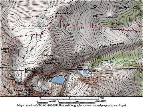
Storm Peak
Driving: The standard approach for Storm Peak is using the East Longs Peak Trail.
Drive 8.6 miles south of Estes Park on Hwy. 7 (S. St. Vrain Avenue). It is a right hand turn (west) and well marked. Follow Longs Peak Drive (passing the Rocky Ridge Music Center) for an additional mile to the trailhead.
Hiking: The turnoff for Estes Cone/Eugina Mine is .5 miles from the trailhead. Battle Mountain group camping site is 2.9 miles from the trailhead and Chasm Junction is 3.1 miles.
The Boulderfield is about 6 miles. Leave the trail at the Boulderfield and rock-hop/scramble due west up the gentle slopes to the summit.
Half Peak, another unranked RMNP summit is only another .5 mile north of Storm for extra credit!
Necessary Equipment
Since Storm Peak is only a class-2 scramble, expect to take the usual barrage of hiking equipment (poles, boots, long-sleeve shirt, hat etc.). I will mention however, weather can change rapidly at the Boulderfield and Storm Peak due to the topography of Longs Peak. So be in preperation for storms, rain or sudden blizzards.I've stopped counting the number of times I've been caught in white out conditions from either sudden snow squalls or dense cloud.
Always be prepared when venturing into the alpine!!
Camping
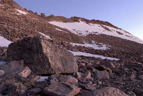
Eastern Slope of Storm Peak
Because Storm Peak shares the same trail and campgrounds as Longs, expect a lot of people when using the following suggestions/areas (as a rule).
If camping at a NPS regulated site, bear cannisters are now required as of two-three years ago.
- Longs Peak Campground
This is a first come, first serve area located near the Longs Peak parking lot (trailhead). The associated fees are $20.00/night (May-Sept.) and $14.00/night (Sept-Nov.). This area is located at 9,500ft and has 26 tent sites. RV’s are not allowed. Water is available and the campground generally opens for the season late May. This can be a great option but keep in mind, due to the popularity, noise will probably be an issue. It’s recommended to arrive early. Longs Peak .pdf map
By the way, car camping is NOT ALLOWED at the parking area proper. The rangers will dissuade anyone from doing so and dole out tickets to those who refuse to move. Though, this seems to be enforced perhaps 40% of the time.
Backcountry Office reservations: 970.586.1242
- Goblins Forest
This camping area (tent or bivy only) is located in the thick of the lower forest. It lies about 1.2 miles from the trailhead and has six sites with a centrally located privy. Water is available via Alpine Brook. In the summer, mosquitoes can be obnoxiously bad, so remember to bring the Deep Woods Off! This is marked along the main trail. Permits are required and is considered a backcountry camping area.
Goblins Forest .pdf Information
- Boulderfield
This is undoubtedly the closet and most convenient camping area to Storm Peak. Winds can be atrocious in the Boulderfield being that it lies some distance above treeline, so secure that tent!
There are 9 sites available of varying size. An outhouse is also present. Water can be obtained from Boulder Brook under the talus. Due to the large presence of people, I would boil water even up here (12,760ft). This is located about 6 miles from the trailhead. Noise is generally not a problem even due to this areas popularity but come summer, you may find a marmot or two begging for scraps or the high pitched peeps from pikas! Permits are required.
Boulderfield .pdf
- Moore Park
This is one of my favourite camping areas in the entire Longs Peak area because of the high degree of privacy. It is 1.7 miles from the trailhead and only contains 2 camping sites. An outhouse/privy is also present. It is located along the Eugina Mine/Estes Cone trail. Mosquitoes and ticks can be problematic so again, Deep Woods Off! is your friend.
Water is available from Inn Brook and permits are required.
Moore Park .pdf information
- Olive Ridge
This campground is located about 12 miles south of Estes Park and is very large. It will accomodate both tents and RV's. There are 26 RV sites and 30 tent sites. Picnic tables are at every site as are firerings. Water is available on site. Even despite the sheer size of the area, noise isn't too bad because of the thick forest. This campground functions on both a reservation system and first come, first serve. It is open from mid-May to about late September. Fees are $18.00
Boulder Ranger District: 303.541.2500
Olive Ridge Camping Area
Red Tape
Since Storm Peak lies within the jurisdiction of the National Park Service, all the normal, ticker-tape rules and regulations will apply. Make sure camping is done in designated areas, no fires outside of preexisting fire rings and pets & firearms are not allowed. Wandering off desginated trails is frowned upon.The NPS (ROMO) has no problem in doleing out citations to people.
Also, bear cannisters are now mandated during summer when camping until mid-September. They will check for these and again, dole out fines for not having them. FYI.
Extraneous Pictures
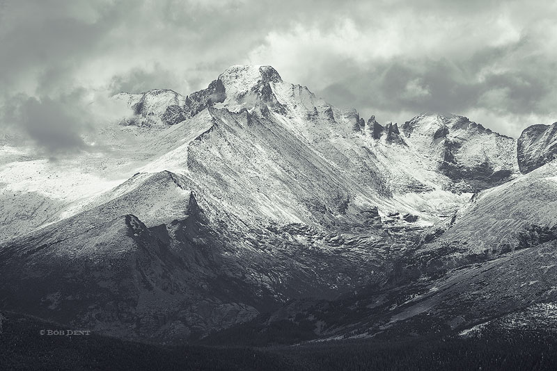 Longs Peak, Storm Peak, Keyboard of the Winds and Glacier Gorge during less than ideal weather |  Half Peak, Storm and Longs Peak as viewed from Bierstadt Lake." |
 Lenticular Clouds over the Longs Peak massif |
External Links
Storm Peak photo Album --via SP Member, SenadR
"Longs and Friends" --Trip Report by Von Mackle
Good pictures!
Mini Trip Report
---Blogspot
Book Excerpt on Lady Washington & Storm Peak Google Books

Rocky Mountain National Park
Sarah Simon - Jan 14, 2010 5:42 pm - Hasn't voted
Sub-PeaksHey there, I have a hard time thinking of Mount Meeker as a sub-peak to anything, Longs or otherwise: Storm Peak is one of the three major sub peaks (alongwith Mount Lady Washington and Mount Meeker) Perhaps you meant to include Battle Mountain in this list, instead of Meeker? Also, as a courtesy, please see spelling correction in bold. Cheers! Sarah