
-
 73186 Hits
-
 92.8% Score
-
 40 Votes
|
|
Mountain/Rock |
|---|---|
|
|
39.14300°N / 113.409°W |
|
|
9654 ft / 2943 m |
|
|
Overview
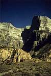
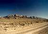
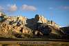
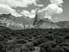
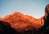
After viewing any photgraph of the west side of Notch Peak, it's obvious what stands out about this mountain. The lime stone monolith block that constitutes Notch Peak is one of the highest points in the House Range complex, and the enormous west face of Notch Peak has been called "the desert equivalent of Yosemite’s El Capitan"; its rise of nearly 4,450 feet makes it one of the highest cliffs in North America. The north face has an uninterrupted vertical rise of over 2,000 feet.
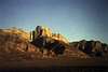
The House Range complex is located in Utah's west desert in the Great Basin. Along the ridgline of the range there is a massive limestone cliff that winds its way along the entire length of each of the three sections of the complex, often reaching uninterrupted heights of over 1,000 feet.
While much of the House Range is dominated by pinon-juniper or sagebrush-shadscale communities, impressive stands of large aspen and conifers grow at higher elevations. The highest ridges and peaks support a healthy population of ancient bristlecone pine. Sagebrush, shadscale, Mormon tea, and various annual and perennial grasses cover the undulating western slopes.
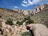
While mining exploration historically took place at the base of these slopes, the predominant current use appears to be sheep grazing in the winter. Camping, hunting, rockhounding, and hiking also occur. The western alluvial fans offer tremendous views of the spectacular lime stone escarpment on Notch Peak itself. And views from Notch Peak and Bald Mountain offer unparalleled panoramas of valleys and mountains for a hundred miles in any direction. One can even see the Bonneville Salt Flats 120 miles to the north.
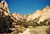
The Notch Peak area has outstanding opportunities for solitude when considered as an extension of the Notch Peak Wilderness Study Area (WSA).The open brush- and tree-covered western benches of the House Range have a subtle but complex topography that offers solitude. Tall stands of trees and the narrow, deep canyon bottom offer outstanding opportunities for solitude.
Besides solitude, the range has exraordinary opportunities for rock climbing, spelunking. It is also contains extremely interesting geological formations resulting from the limestone, granite, quartzite, etc.
Note: Much of this initial descriptive information is being quoted from the BLM's report of the area.
 |
 |
 |
 |
 |
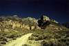
Getting There
The peak is located 120 miles south west of Provo, Utah, so it is a bit of a drive to get there.
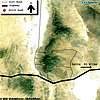
East Side - Sawtooth Canyon Approach:
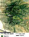
From Delta, Utah, take Highway 6 (aka Highway 50) west 40 miles. From here you turn north (right) on to The Notch Peak Loop Road (unpaved) just before the road rounds the southern tip of the range, just before mileage marker 46. Drive 4 miles north to the signed Miller Canyon Road, and then turn left. Drive another 5 miles to a sign that points left to Sawtooth Canyon. A short ways later you will encounter a log cabin on the north side of the road and a stone road block. Continue on up the canyon dirt road by foot from here, and it eventually turns into a trail.
West Side - North Face Approach:
Same as east side, but take the first dirt road on the right after rounding the pass. Look at the maps on the site for further directions.
 |
 |
 |
 |
 |
Climbing Notch Peak
Some Highlights:
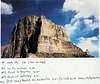
- Swiss Route (North Face) - V 5.10+ A2 (18 pitches) - climbed by Thomas Koch and Peter Deinen in 1986. No one is known to have repeated the route. An account of the climb can be found in the 1987 AAJ pg.128
- North West Ridge - II 5.8 (8 pitches) - climbed by Jim Howe and Jason Keith in February of 1998.
- Book of Saturday (North Face) - V 5.11R (12 pitches) - climbed by Robert Price and Tom Lyde in May of 1999.
Brent Higgins has provided links to two great reports of an ascent of Book of Saturday:
- Book of Saturday's on Notch Peak, 7/7/05 by Brent Higgins
- Top-Notch climbing by Bryce Peterson Jr. from the Standard-Examiner
Howe adds:
Here's a little enticement to whet the appetite for the adventurous.
In addition to these routes there is a new route to the right of "Appetite" called "Western Hardman"
I recently found a book that covers some route on this enigmatic peak, but the book is not listed on Amazon.com
IBEX and selected Climbs of Utah's West Desert by Jame Garrett 2001
ISBN: 1-892540-08-8 A Cobbler Graphics Production
I came across this book in Wilson's East Side Sports in Bishop, CA .
A lot of web sites selling the book can be found by searching for the title name.
 |
 |
 |
Red Tape
As far as I know, the only rules to be followed are those that apply to all Wilderness Study Areas.
Some obvious rules are keeping vehicles on established roads, and following general minimum impact techniques. No permits or fees are needed to climb the peak or camp in the range. Take care as to the selection of a campsite , since there are no campgrounds in the WSA.
 |
When To Climb
Spring and Fall are the best times to climb due to the lack of snow and cooler temperatures. I haven't climbed in the other seasons, but I'd expect the main difficulties in the winter to be light or sporadic snow cover. In the summer the air temperature often exceeds 100 degrees farenheit, and there isn't much shade. During the spring there are a number of springs that are good for drinking water. Except for these springs, there are NO OTHER SOURCES OF WATER, so bring plenty of it.
External Links
- Hempweaver.com
Provides some more general info about the area, routes, and lots of good photos - The House Range, Millard County, Utah, by Jim Drysdale
- BLM Document
Provides some more general info about the House Range and discusses its Wilderness Area Eligibility - SUWA
Good general description of the House Range and Notch Peak - Notch Peak Ascent on DesertRatsAnonymous
Slideshow and account from a summer 2005 ascent of Book of Saturday's on Notch peak. - A TR of an ascent of Book of Saturday (V 5.11a) on the north face. - by Brent Higgins
- Standard Examiner article on an ascent of Book of Saturday by Bryce Peterson Jr.
Notch Peak South Wall from Marshall Miller on Vimeo.
Scott - Dec 14, 2005 3:06 pm - Voted 10/10
Untitled CommentThat is an very interesting TR you have. Tough climb.
You may want to go to the trip reports section of this mountain page and attach the URL.
PellucidWombat - Dec 16, 2005 10:32 pm - Hasn't voted
Untitled CommentThanks for posting! Both articles were very interesting, and it was nice seeing photos of the face and the approach. Bravo on a successful and safe climb! I'll put in links on the page, but feel free to submit photos here if you wish.
swervn - Aug 28, 2005 5:01 pm - Hasn't voted
Untitled CommentHere is the url to my West Desert Basin and Range web page with info on the House Range and more.
http://members.aol.com/fivepoint7
Brent_Higgins - Dec 14, 2005 12:32 pm - Hasn't voted
Untitled CommentFor a bunch of pics and an account of climbing Book of Saturdays see
http://www.desertratsanonymous.com/Climbing/Notch_Peak/Notch_peak_index.html
Enjoy,
Brent
Dean - Nov 1, 2007 11:32 am - Voted 10/10
Broken linksSadly, most of the links shown at the bottom are now useless. Just a head's up.
MoapaPk - Jun 25, 2010 12:19 am - Voted 10/10
VariousThe driving route shown (in my map, linked to this peak) is accessible to a modest-clearance vehicle. The 2006 Wilderness closures keep one from driving all the way in, but it is still possible to camp at 6850'. Only the last 3 miles require modest clearance (my 2003 outback, with 7.3", did just fine). This map shows the southern route, which has a trail (herdpath) most of the way; my route diverged from the trail, which (I think) is closer to the magenta dotted line. The north route is totally trailless and has a very nasty dryfall, and an almost-as nasty cliff band on the way (at least they seemed nasty on the downclimb). I think this N route is similar to Nick N's route.
runbyu1 - Jun 9, 2013 9:51 pm - Voted 9/10
June 2013 UpdateHere's my update from my trip yesterday: -The turnoff is right at the mile 46 marker -The dirt roads get progressively worse. The first one is quite nice, the 2nd one is worse and is 5.1 miles from the turnoff (The sign is eroding but still visible), the 3rd dirt road has a sign pointing to "notch peak trailhead". From here it was 3.2 miles on a pretty crappy dirt road. We made it in my low clearance car but hit a few nasty rocks and were definitely concerned about worse damage and flat tires. Once you get there, the road dead ends and there is a sign signifying "Notch Peak Trailhead". -The trail (South route signed by several cairns about .7 miles from the start) is in good condition, a bit overgrown but easy to follow. Once you get out of the wash, there is about 1/2 to 3/4 of a mile of cairn following that is tough. Once you get to the cliff overlook, it is easy to find the way up left to the top.
SabineInUtah - Oct 22, 2014 12:55 pm - Hasn't voted
DistanceI haven't found information on the hiking distance from the TH via Sawtooth Canyon to the summit, but estimate it to be about 6 miles. Climbed the peak on Oct. 17, 2014 and the route was easy to find via the canyon and beyond to the saddle and summit. The road in is very rough. We decided to camp about a 1/2 mile from the TH and hiked from there.
greatbasinmarmots - Jun 20, 2018 6:52 am - Hasn't voted
warning about road leading up to trailheadPlease note that you should have--at the very least--good clearance and all-terrain tires to get up the road to the Notch Peak trailhead. Highway tires (4-ply) do not cut it. You might make it, but you are taking a great risk. Best to just park at the main entrance and walk the ~3 miles to the trailhead, adding the requisite amount of water to make up for the extra two hours of hiking. (Interesting that the road to the hiking trailhead is crap, while the road leading to the ORV trails is an improved gravel surface. Utah priorities, I suppose.)
T. White - Aug 12, 2019 5:44 pm - Hasn't voted
Re: warning about road leading up to trailheadGood to know, and sad to hear. That ORV factoid is just too rich.