
|
|
Mountain/Rock |
|---|---|
|
|
39.23860°N / 105.497°W |
|
|
12431 ft / 3789 m |
|
|
Lost Creek Wilderness Overview
First, the mountains of the Lost Creek Wilderness submitted here on Summitpost are exclusive to this site. Locating information or any route beta for this area is difficult. Thanks to Jennifer and Gerry Roach's LCW book all of us can view photos and visit these remote summits here on SP.
The Lost Creek Wilderness Area protects nearly 120,000 acres in the Tarryall, Platte River and Kenosha mountain ranges in central Colorado. This relatively new wilderness (designated in 1980) is loaded with hiking, backpacking and climbing possibilities. Typical LCW landscape will consist of mixed and very dense forests, open meadows, small streams; somewhat the norm for Colorado’s high country. Upon first sight, it’s possible the casual climber or mountaineer may not be too impressed with the typical LCW mountain configuration. Dense, tree- laden slopes that frequently lead to tree-covered summits could easily rekindle a forgotten bad memory, a memory that includes your most frightening bushwhacking experience.
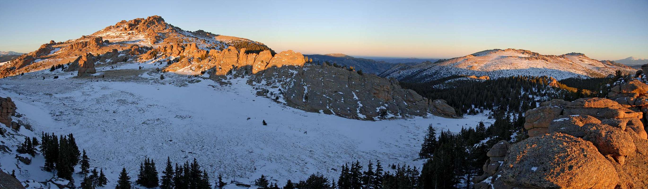
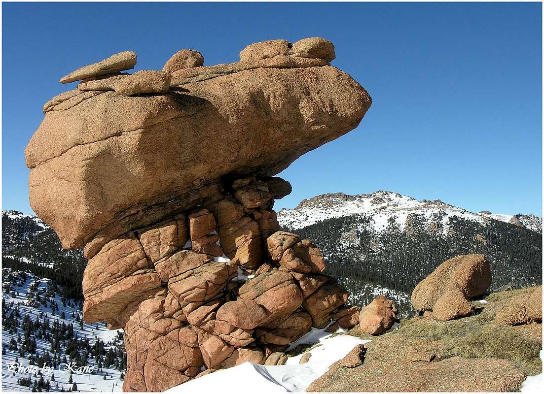
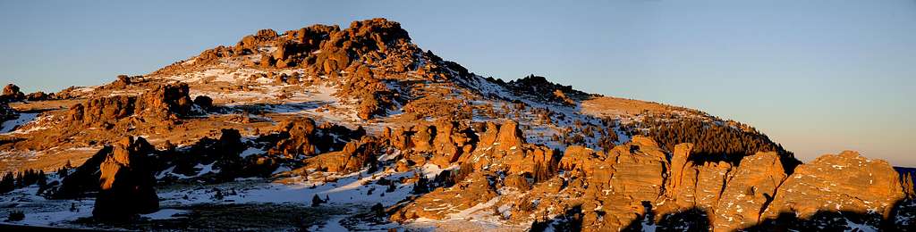
However, despite lacking the grand alpine scenery of other Colorado wilderness areas, one can argue that LCW may be one of the most unique Wildernesses in Colorado. Upon closer inspection the LCW has its own character that no other place in Colorado can match. Character that includes some of the most bizarre rock formations you will ever see. A lot of the LCW is dominated by these incredible rock formations, including massive polished granite domes and towering spires. With elevations ranging from 8,000 to 12,400 feet, many of the mountains here sport huge, wide-open plateaus providing easy hiking and excellent views. Getting to those plateaus is another story.
Tarryall Mountains
Anchoring the Tarryall Mountains to the north is North Tarryall Peak at 11,902-ft, and anchoring the southern end of this range is the lonely South Tarryall Peak at 11,206-ft. This small, 16-mile Colorado mountain range resides within the Lost Creek Wilderness boundary. For viewing purposes the Tarryall Mountains can easily be split into two distinctive sub-ranges; the north and the south.
The north Tarryall's include North Tarryall Peak, Topaz Mountain and Bison Peak. The south Tarryall's include McCurdy Mountain, McCurdy Park, "Tarryall Peak," the "Catamount," Lake Park, "Lake Park Peak," and South Tarryall Peak.
These complex mountains offer an arid climate for Colorado, as well as excellent hiking and climbing during winter and spring. When the mighty Colorado Fourteeners are draped in snow, conditions in the Lost Creek Wilderness usually permit easier hiking and climbing. Because of the lower altitude and the arid climate, summers in the LCW have a reputation for staying hot.
This area also presents some worthy technical climbing in Colorado, you just have to go and find it. The LCW is known for long approaches, which reserves this area for those that can handle a 2,000-ft, 4-6 mile approach to get to the goods. I would be careful not to underestimate the low elevations of the Tarryall Range, for these mountains are remote; plus once you're off trail the tree-laden landscape can present a navigational nightmare.
Bison Peak Overview
Having hiked in the nearby Platte River Mountains and the Kenosha Mountains, nothing beats the Southern Tarryall's when it comes to the bizarre and beautiful rock formations that provide the visual blueprint of the Lost Creek Wilderness.
Bison Peak represents the Lost Creek Wilderness "twisted granite" theme with all out passion. Bison Peak (12,431 ft.) and McCurdy Peak (12,168 ft.) reign supreme within the Tarryall Range. Bison Peak has an expansive summit plateau allowing you an endless opportunity to roam the rock gardens at will.
Just remember to bring a lot of camera film to capture Bison's unique landscape. If Bison Peak was a 14er perhaps it would be Colorado's most popular mountains, but the reality is Bison is not popular. It is for this reason that this peak will deliver huge solitude and 12.2 miles of easy class 1 hiking and 3,800 ft. of vertical gain. Mountaineering icons Gerry and Jennifer Roach sum it up best "You can hike hours through trees, then burst upon a private universe far above roads and cities. These summits let you taste freedom and touch the sky. They will draw you back."
Bison Peak's standard Southwest Ridge Route is a class 1 hike on a good trail for almost the entire 12.2 mile RT. Also, the trailhead is at 8,760 ft. and the route gets southern sun exposure making this an ideal hike for early Spring. When I hiked Bison on April 12, the snow level was 9,500 ft. At 10,500 ft. snowshoes were a must, without them I would have never made it. If your thinking about an early Spring ascent of Bison, be sure to start as early as possible, take advantage of the hard snow pack for when it heats up later in the day it makes for a postholing nightmare. There is no avalanche danger along this entire route.
 |
 |
 |
 |
 |
Ute Creek TH- (8,760-ft)
From Denver Colorado travel Hwy 285 past Aspen Park, Conifer, Pine Junction and Bailey. Continue to Kenosha Pass where you will find the Kenosha Pass campground. This is a very popular campground on the weekends, arrive early with $7.00 to reserve a spot. It is only one hour from Denver to Kenosha Pass. Continue to the tiny town of Jefferson and turn left on Park County 77 (Tarryall Road). This road is located directly before Jefferson's only convenient store. Continue 16.9 miles on the rough paved road to Tarryall Reservoir, it may have water it might not. The Ute Creek Trailhead (8,760 ft.) is 3.3 miles beyond Tarryall Reservoir on PCR-77 to the left. There is plenty of parking. It shouldn't take more than two hours to get to this TH. I made it in an hour and a half.
This trail provides access for climbing Bison Peak and McCurdy Mountain. Several extended loops can be done from this point.
Points of interests:
- Kenosha Pass had long served as an Indian trail into the hunting grounds of South Park. White parties began to pass through this pass in early 1830. When miners began to pass through the area, they paralleled the old Indian trail then veered west to Georgia Pass, which today marks a segment of the great Colorado Trail.
- The Colorado Trail makes its first crossing of the Continental Divide in this segment.
- In 1861 when the stage line began operation over this pass, a driver of the line, Clark Herbert named this pass after his hometown Kenosha, Wisconsin.
Lost Park TH- (9,980-ft.)
From Denver Colorado travel Hwy 285 past Aspen Park, Conifer, Pine Junction and Bailey. Continue to Kenosha Pass where you will find the Kenosha Pass campground.
From Kenosha Pass, descend the pass and when 285 levels out, look sharp for RD-77 on the left. Turn south on to RD 77 and follow this road 19 miles to the Lost Park Campground. RD-77 is a dirt road with plenty of “washboard” driving. Bring your SUV for this improved dirt road, but a passenger car would be sufficient if needed. This TH is closed starting early Nov and re-opens in late April or May.
Camping
Here is an excellent link for area camping. Make reservations for Kenosha Pass campground here. USDA Forest Service
Car camping is easy in the Lost Park area. Closest lodging would be Fairplay, Colorado. I wouldn't bother with lodging; you're too close to Denver. Camping would be a much better alternative.