
-
 93596 Hits
-
 76.64% Score
-
 7 Votes
|
|
Mountain/Rock |
|---|---|
|
|
38.46230°N / 79.2419°W |
|
|
4397 ft / 1340 m |
|
|
Overview

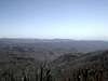
Reddish Knob is a very well known peak for mountain bikers. It is located on the border of Virginia and West Virginia, more specifically the border of Augusta County, Va. and Pendleton County, West Va. It is in George Washington National Forest in the Shenandoah Mountains. Mountain bikers frequent the one lane asphalt road which reaches the summit. On the summit, you will find an asphalt parking lot and the remains of a look-out tower. There are great views for 360 degrees looking into West Virginia and back to the east, into Virginia. Reddish Knob can be accessed from a hiking trail which departs Route 924 and heads up the mountain for approximately 4 miles to the summit.
 |
Getting There
Departing from the Washington, D.C. area, use Interstate 66 westbound to it's terminus at Interstate 81. Follow Interstate 81 southbound until you reach the city of Harrisonburg, Va. At this point, exit the interstate and head west on Route 33 towards the West Virginia state line. Once through Harrisonburg (best spot for last minute supplies), follow Route 33 to Hinton, and make a left turn onto Route 613. This road will meander through some real pretty mountain valleys and nice farms. Go through the small towms of Cloverhill and Ottibone until you connect with Route 924. Follow Route 924 to the ridge line and the border of Virginia and West Virginia. At the top of the ridge line, you should make your immediate left onto the one lane paved road and follow this to the summit. Be careful on this road. It is a two way road with few pull-overs. It is also traveled by lots of mountain bikers. If you are hiking, look for the trail halfway up the mountain on your left-hand side of Route 924.
Red Tape
There are no fees associated with climbing Reddish Knob.
The park is open year-round. Accessibility may be a problem in the winter months due to the steepness of the roads / trails.
When To Climb
Reddish Knob is accessable year-round.
Camping
There are numerous camp-sites available near Reddish Knob. Once you reach the top of the ridge, rather than make the left to Reddish Knob, turn right and follow the dirt road which leads to Bother Knob and Flagpole Knob. Along this dirt road, there are numerous sites which are free. There are not any facilities with these sites.
At the bottom of the mountain is Hone Quarry which has actual camp-sites with facilities. There is a $5 per day fee for camping. This is actually a really nice spot located along a beautiful trout stream. Just beyond the camp-sites is Hone Quarry, a man-made lake stocked with trout. There are also lots of mountain trails which originate from this area.
Mountain Conditions
Contact the Park Service at Dry River Range: 540-828-2591
southernregion.fs.fed.us/gwi/
Average Temperature / Precipitaion
Averages shown are for the city of Harrisonburg, Virginia. Average temperatures shown are for monthly averages of highs and lows.
January 32.1 / 1.56
February 39.0 / 0.76
March 38.6 / 3.57
April 55.0 / 1.49
May 59.8 / 2.54
June 68.5 / 2.79
July 70.3 / 3.68
August 72.8 / 4.45
September 63.1 / 1.13
October 54.2 / 0.65
November 49.9 / 0.45
December 41.2 / 1.72
Weather Forecasts
theme=default&user=default&forecast=hourly&place=Harrisonburg&state=va&zipcode=&icao=KSHD&country=us&bgc=&tc=&t=&metric=0&display="border="0"width="175"height="90">
theme=default&user=default&forecast=zone&zipcode=&place=Harrisonburg&state=va&country=us&bgc=&tc=&t=&metric=0&display="border="0"width="330"height="203">