
|
|
Mountain/Rock |
|---|---|
|
|
37.72859°N / 119.53253°W |
|
|
7076 ft / 2157 m |
|
|
Overview
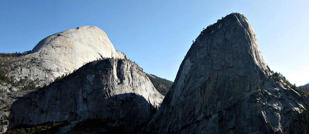
Liberty Cap is the impressive-looking peak towering over the north side of Nevada Falls in Yosemite National Park. Though the peak is prominent and has a nontechnical route in the class 2-3 Northeast Gully, it is relatively infrequently climbed compared to the throngs of visitors that make the hike up the popular Mist Trail to Vernal and Nevada Falls. The approach uses perhaps the most popular trail in the entire park (for good reason) and is extremely moderate by most standards.
The views of the falls and other features on the Merced River are extremely rewarding but can be somewhat crowded in the spring and summer months. Just a quarter mile away and 1200 feet above the top of Nevada Falls, however, Liberty Cap promises solitude and spectacular views of Yosemite Valley, Half Dome, and the Yosemite high country beyond.
There are many technical big wall climbs available on the southwest face of Liberty Cap, but the few visitors who make the summit most frequently utilize the scramble up the Northeast Gully. The trip can be made year round and is well worth the small additional effort if completing a short hike in the area.

Getting There
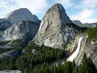
Nevada Falls and Liberty Cap

Liberty Cap from Washburn Point
Unless taking a route that is a bit bizarre, trips to Liberty Cap and the surrounding area being at the Happy Isles Trailhead in Yosemite Valley.
Happy Isles (37.73519° N, 119.56519° W)
Follow Highway 120, Highway 140, or Highway 41 into Yosemite National Park and follow signs for Yosemite Valley destinations. Once in Yosemite Valley, simply follow the southside loop road straight, pass Curry Village and the turnoff for Upper Pines Campground, and reach the Happy Isles Trailhead on the right side of the road. Note that the road continues about 0.3 miles past the trailhead but personal vehicles are not permitted.
Approach
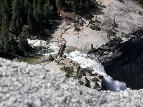
Nevada Falls Footbridge from the Summit of Liberty Cap... Yikes!
Trip statistics from Happy Isles Trailhead for the Northeast Gully:
3.8 miles one-way, 3200 feet total elevation gain with negligible gain on the return
Begin at Happy Isles in Yosemite Valley and follow either the John Muir Trail or the Mist Trail to the top of Nevada Falls. Both are extremely rewarding routes and if planning a loop I would recommend the steeper and wetter Mist Trail for the ascent and the gentler John Muir Trail for the descent. If aiming for one of the technical routes on the southwest face simply detour off the trail as it approaches the face just below the top of Nevada Falls.
For the Northeast Gully continue past Nevada Falls east for about a third of a mile and look for a use trail that ascends the shallow ridge to the left (north). If you reach the trail junction between the continuation of the JMT and the route further into Little Yosemite Valley then you’ve gone just a bit too far and can either retrace your steps or go ahead and bushwack up the short ridge.
From the granite slabs on the ridge the Northeast Gully is visible. The route is straightforward class 2-3 up the gully with no exposure or route finding difficulties.
Route Overview
Although most ascents of Liberty Cap are made via the non-technical Northeast Gully, there are also big wall climbs accessible on the opposite face. Access to the technical routes begins off the Nevada Falls Trail as you approach Nevada Falls from above Vernal Falls.
| Route | Grade | Rating | Aid |
|---|---|---|---|
| Northeast Gully | - | Class 2-3 | - |
| Passport to the Sky | V | 5.11 | A1 |
| Scarface | V | 5.8 | A3 |
| West Buttress | V | 5.10 | A3 |
| The Patriot Act | V | 5.9 | A3+ |
| Southwest Face | V | 5.9 | A3 |
| Bad Moon Rising | V | 5.8 | A2 |
| Direct Southwest Face | V | 5.10 | A3+ |
| Turkey Shoot | V | 5.9 | A3 |
| A Joint Adventure | V | 5.10 | A3 |
Red Tape
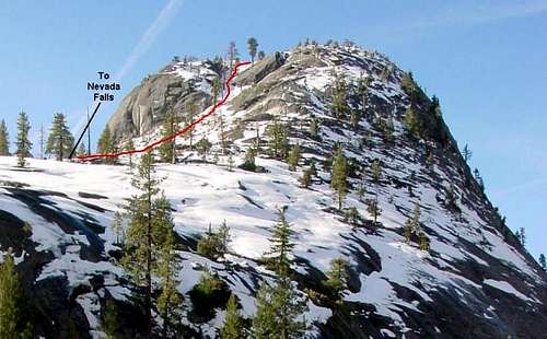
The Northeast Gully
Entrance Fees:
Access to Liberty Cap is through Yosemite National Park and an entrance fee is required. The Yosemite fee page has full details.
Wilderness Permits:
Permits are required for overnight trips, but be aware that Yosemite has perhaps the worst permit pickup process in all of California. After hours pickup is not available, and if arriving in the morning expect to wait in line 1 ½ to 2 hours even with a reservation. Permits can be picked up at the Yosemite Valley Wilderness Center in Yosemite Village during open hours.
This is one of the most popular trailheads in Yosemite, and subject to quotas from November through April, so if seeking a permit reservations far in advance are highly recommended. Permits are self-issue 24 hours/daily at all wilderness centers outside the quota season. Check the Yosemite permit page for full details on hours, the reservation process, and reservation availability.
Food Storage:
Bear canisters are required throughout Yosemite National Park. Even so… some don’t carry them. If staying in Little Yosemite Valley note that canisters are not actually required as bear boxes are available.
Campfires:
Fires are prohibited above 9,600 feet.
Yosemite National Park Wilderness Permit Office
PO Box 545
Yosemite, CA 95389
Phone: (209) 372-0740
Fax: (209) 372-0739
Current Conditions
Current NOAA / National Weather Service Forecast
When to Climb
Liberty Cap is a great year-round destination with no particular winter access issues. In winter chains or 4wd may be needed depending on road conditions. Immediately after a winter storm snowshoes may be necessary, although frequently crampons and ice ax will be sufficient. By spring generally no special gear is needed.
 |
 |
 |
 |
 |
 |
Camping
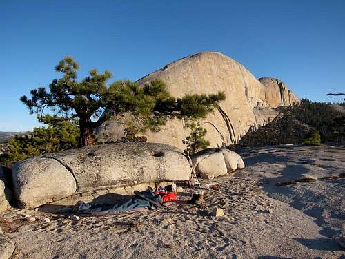
Bivy on the Summit of Liberty Cap
Liberty Cap has a relatively short approach and a round trip can be accomplished in as little as half a day. Many visitors consequently aren’t seeking overnight trips. Backpackers will normally be limited to the established sites available in Little Yosemite Valley, not quite a wilderness experience but at least bear lockers are available.
Another option is to bivy right on the summit of Liberty Cap. I am not sure if this is permitted, but no one is there to stop you if you do. Regulations prohibit camping along the trails prior to reaching Little Yosemite Valley.
Roadside camping is not permitted in Yosemite. Established campgrounds are available within Yosemite Valley and reservations are highly recommended outside the winter months. See the Yosemite Campgrounds page for additional information.
Etymology
“Broderick’s name was originally placed on what is now known as Liberty Cap. (Whitney Survey, Geology, 1865, pp. 418-419.) Displaced in 1865. … On Wheeler Survey map of Yosemite Valley, 1883, it appears in the present location. David Colbert Broderick; born in Ireland, 1820; U. S. Senator from California, 1857-1859; killed in a duel with David S. Terry, 1859.”– Francis P. Farquhar, Place Names of the High Sierra (1926)
“The resemblance in form of the mountain to the cap of Liberty on the half-dollar of the early nineteenth century was brought to the attention of Governor Stanford in 1865 by J. Hutchings. Standing before the mountain, Stanford proposed that it be called Cap of Liberty instead of Mount Broderick or other names by which it had been known. (Hutchings: In the Heart of the Sierras, 1886, p. 445.) In recent years the name Liberty Cap has become the usual form.”– Francis P. Farquhar, Place Names of the High Sierra (1926)