
|
|
Mountain/Rock |
|---|---|
|
|
40.00700°N / 105.688°W |
|
|
12814 ft / 3906 m |
|
|
Mount Neva Overview

The Colorado Indian Peaks Wilderness is home to many of the best hiking and climbing routes in the state. All 73,391 acres of The Indian Peak Wilderness rests just south of Rocky Mountain National Park; it's basically an extension of its neighboring national park. As Gerry Roach notes in his popular book "It's smaller than Rocky Mountain National Park but no less spectacular." This impressive collection of jagged peaks is home to 35 named peaks and 23 of are over 12,000 ft., and seven are over 13,000 ft. From easy walk-ups to technical 5.5 climbing this mountaineering playground has something for everybody. Only 2 hours from Denver Co. they are a popular destination for the day hiker, but having and experiencing solitude can be had for those willing to look for it.
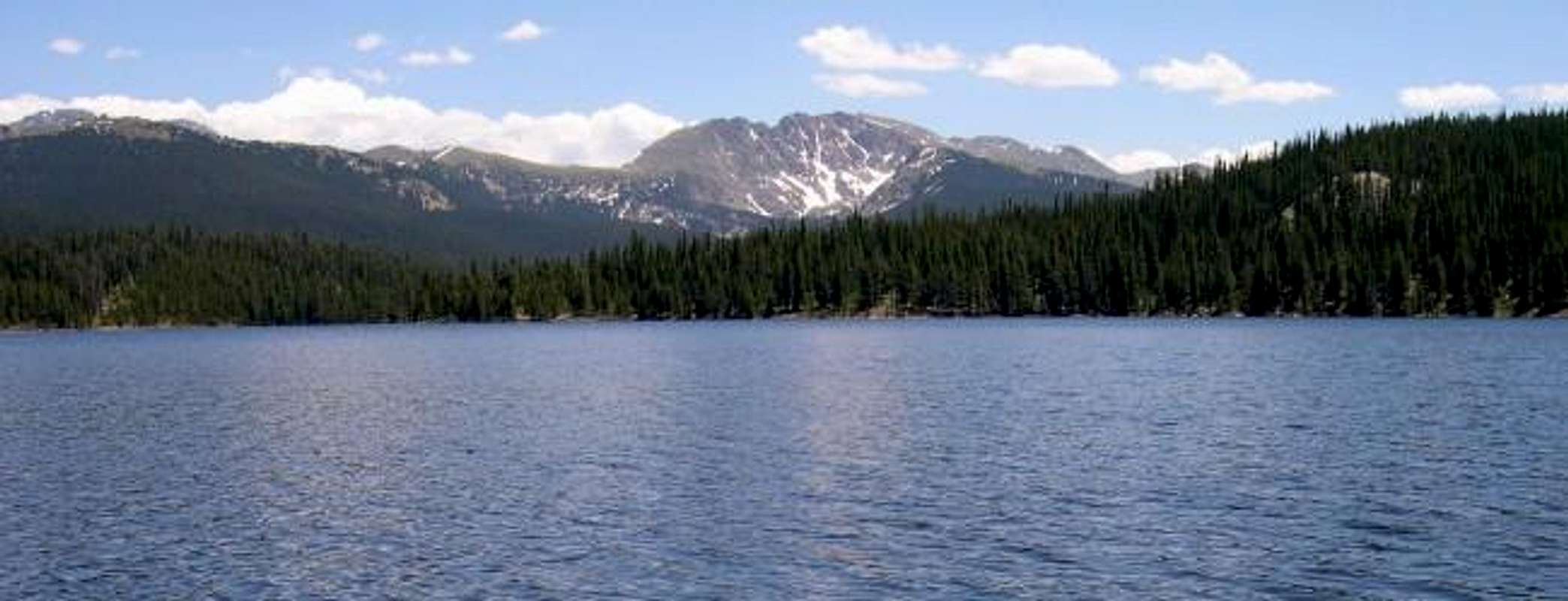
Mount Neva (12,814-ft) stands prominently overlooking the Frasier Valley to the west and the Arapaho Pass area to the east. Recently, Mount Neva has started to develop a mountaineering reputation for its snow climbs. These east facing couloirs are clearly visible and easy to preview from the Arapaho Pass Trail, and the twin summits of South and North Arapaho Peak. These beautiful snow couloirs are sometimes climbable all the way into middle July. Mount Neva is connected to Jasper Peak by its long class 2 south ridge.
Through mid July and the remainder of fall, Mount Neva is not a popular destination, this should not be so, for this shy and reclusive peak has an abundance of charm. Although Neva’s elevation is low compared to its surrounding neighbors, the mountain is very complex.
Mount Neva’s cirque-like east face, supports the Desdemona Couloir and the Juliet Couloir that provides the melt-off for Lake Dorothy. This picturesque lake is nestled at the base of Mount Neva’s east face and is a popular day hike for Front Range residents from the 4th of July TH. Mount Neva also has a huge concave west face, which supports Columbine Lake that eventually feeds Monarch Reservoir to the north. From the west, Mount Neva provides a wonderful day hike through the Columbine Lake area and continues up the class 2 Northeast Ridge Route. Also, Neva has the classic class 4-North Ridge Route that begins at Arapaho Pass. This long traverse has challenged many mountaineers over the years and seems to get more popular every year. The north ridge is not a long as the neighboring Arapaho traverse but does require more technical expertise. Lastly, Mount Neva is connected to Jasper Peak
 |
 |
 |
 |
 |
Route Description
The standard route for Mount Neva from the west side of the Indian Peak Wilderness is the Northwest Ridge Route. This route is only eight miles and 2,800-ft of elevation gain and begins at the Junco TH at 10,050-ft. This is an unusually high TH for this side of the Indian Peaks, so take advantage of it. Recently I have discovered that I really enjoy loop hikes, and don’t mind the extra effort to experience new terrain on the descent. Loop hikes can be very rewarding but keep in mind that good route finding skills are necessary for anything off the standard route. The route I have submitted is a loop variation of the standard route that will add an additional 400-ft of vertical and one additional mile to the overall roundtrip. Thus, the loop variation from Junco TH is route is 9 miles and 3,000-ft of elevation gain.
 |
 |
 |
 |
 |
Junco Trailhead-Western Approach
In Roach’s IPW guidebook he notes that the trailhead for a western approach to Mount Neva is called the Meadow Creek Trailhead. I believe this is incorrect, or the name has since changed. It is now called the Junco Trailhead.
From the town of Winter Park Colorado, go north a few miles to the tiny town of Frasier. From Frasier continue north about 3 miles to a turn off on the right (Meadow Creek Reservoir). This turnoff is right before you drive into the town of Tabernash, so if you start the drive into this town you have passed the turnoff, like I did. There should be a clearly marked sign for Meadow Creek Reservoir here. Follow the road 9 miles to Meadow Creek Reservoir. This road is paved for the first half mile then turns into an improved dirt road, suitable for passenger cars. There are many unofficial campsites along this nice dirt road, which I recommend if you are planning on driving up for the night. The road gets more rough about 5 miles into it. There is also a fee station that takes credit cards at about mile 6; the cost for the day is $5.00.
Once you have arrived at Meadow Creek Reservoir, you can clearly see Mount Neva and its huge west face off to the south. Continue around the reservoir on a good road for about another 1.5 miles to the signed Junco Trailhead at 10,050-ft. There is not an official campground here at the reservoir but locating “wild” campsites around the reservoir is not difficult. I will assume they are first come first serve.
 |
 |
 |
 |
 |
Regioanl Weather
Click image to enlarge
Red Tape
Here is a summery of the Indian Peak Wilderness Rules and Regulations.
- Motorized vehicles are not permitted, including bicycles.
- A permit is required for camping in the wilderness area between June 1 and Sept. 15. Permits are issued for 19 travel zones within the Indian Peak boundaries. Permits are $5.00 at the following offices. For information or to apply for a use permit, contact the U.S. Forest Service, Boulder Ranger District, 2140 Yarmouth Ave., 303-541-2500, or the Sulphur Ranger District, 9 Ten Mile Drive, P.O. Box 10, Granby, CO 80446, 1-970-887-4100. For recorded information, call the Indian Peaks Wilderness Information Line at 303-541-2519.
- Only a certain number of groups are allowed in each travel zone for overnight camping. Camping is limited to two weeks in any four-week period; the two weeks can be in any travel zone.
- Organized groups (maximum size of 12) must have permit for camping or hiking at all times.
- Campsites must be at least 100 yards from lakes and streams.
- Fires are prohibited east of the Continental Divide. Fires are allowed in certain areas west of the divide.
- Dogs must be leashed.
Camping
Inexpensive camping is plentiful in this area. I recommend reading the above “getting there” section that will fill you in as to camping in the immediate Meadow Creek Reservoir area. A day pass of $5.00 is required for overnight use as well. Pick up this day pass at a marked pay station on your drive to the reservoir.
There is also camping in Winter Park. The Idlewild Campground is just south of Winter Park on the right; fee is $8.00 a night. This campground is located nearby some train tracks but what do you expect for camping so close to a city. Also, this campground fills up fast on weekends because its vicinity to Winter Park.
![]()
External Links

Jesus Malverde - Nov 26, 2012 2:13 pm - Hasn't voted
Bone Games: Extreme Sports, Shamanism, Zen, and the Search for TranscendenceAh Mount Neva.. the mountain where in 1964 Rob Schultheis had his mystical mountaineering experience and thus began his inquiry into transcendence, athletic altered states and "the search for the ultimate athletic high." Bone Games, baby! Yeah!