
|
|
Mountain/Rock |
|---|---|
|
|
39.82820°N / 113.9189°W |
|
|
Juab |
|
|
12087 ft / 3684 m |
|
|
Overview
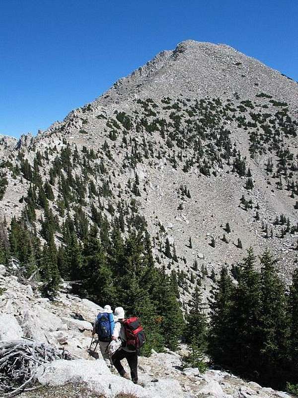
Approaching the last stretch before the summit
Ibapah Peak is located in the Deep Creek Mountain Range. and is visible from the town of Wendover 75 air miles to the north. It is a unique area that is relatively unknown, even by most Utahans, most who have never heard of it. The Range is located in the far West end of Juab County. At 12,087 Ibapah is the 7th highest County high point. It beats out Mt. Nebo by about 100 feet (which sits on the border of Juab and Utah county).
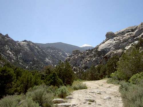
Looking at Ibapah from the road that is on the east side from ten miles away in the early morning light.
It is a place where you need good transportation and much of the drive to get there is on dirt roads. It is mainly approached from the east side since the Goshute Indian Reservation occupies any route that might be available from the west. More about that in getting there.
Trail Head Elevation = 6,887
Summit Elevation = 12,087 ...... 5200'± of elevation gain
Trail Mileage = 12± miles round trip, this is terrain distance.
Note: Elevations were derived from USGS DEM's via GIS.
Getting There
From Salt Lake City head West to Wendover on Interstate 80 for 118 miles. In Wendover head South on US Alt. 93 for about 26 to 28 miles (odometer differences but the turn off is well signed) than turn Left heading South East towards the towns of Ibapah and Callao. Travel South East for 17 miles on the paved road and crossing back into Utah, than turn left onto a dirt road heading towards Gold Hill and Callao. Head 12 miles still in a south easterly direction until you reach Gold Hill. Then turn right and head south for 5 miles where you will come to a “Y” in the road. Stay Left, which is also the Pony Express Road. Travel on this road for 14 miles you will come to a intersection, turn right towards Callao, this road is still the Pony Express Road. Drive South for 4.3 miles at which time you will come to a “Y” intersection, stay right (left takes you to Callao, 1.2 miles). After making your right follow this road for 13 miles to the Granite Creek intersection. At the 5.5 mile marker from the previous “Y” at Callao is the CCC campground. Drive past the CCC campgound until you reach the Granite Creek Road. Turn right onto the Granite Creek Road follow this dirt road while staying left at the Falkenberg Ranch intersection for 4.3 miles to the Trail Head. The first stream crossing is at 2.8 miles and the second is at 3.6 from the beginning of the granite Creek road. As you can see from all the above, it helps to have mapped your way with waypoints beforehand. Benchmark atlas books are also useful on this drive.
NOTE ON THE WESTERN APPROACH:
This was recently posted at the www.cohp.org page
I hiked this route with my family a week ago,and when I got back I found a
note on my windshield indicating that I was trespassing on a private mining
claim. I just got off the phone with Mr. George Fishler, the owner of the
claim, who indicated that we were trespassing from the canyon mouth at about7800' to the mine and somewhat beyond, and that he would not give permission (had we asked then, or in the future) due to liability concerns.
He has no problem with the traditional, east side approach, but indicated that there are private, patented mining claims within the Goshute Reservation boundary in the several of the west side canyons that the Tribal Office has noauthority to give permission to cross.
Information provided by Ken Jones
Red Tape & Topo info
No permits are required. There is enough room for half a dozen cars at the true trail head. I would advise using four-wheel drive or very high clearance vehicles to get to the true trail head.. A two wheel drive vehicle with low clearance is going to make for a longer hike and even with high clearance, you will find it challenging in a two wheel drive rig.
Topo Quads that may be helpful:
USGS Quad 24k, Ibapah Peak
USGS Quad 100k, Fish Springs
USGS Quad 250k, Delta
When To Climb
Rik, the original provider of this page, climbed the peak in mid-July, which probably would seem to be during the hotter time of the year. But since you are shaded for a good portion of the hike you are spared some of the West desert sun and heat.
He commented that he would consider climbing this peak anytime of the year. I climbed the peak in early September and found it to be a great time to do so. Water was still available at a couple spots along the trail but I'm not sure that would always be the case. It had snowed the day before we climbed it and that might account for the water we encountered. We encountered some snow on the trail not far from the summit of Ibapah.
A summit register can be found at the shelter located on the eastern side of the summit ridge. (update: it seems the register has disappeared so future visitors may wish to bring a new one)
Camping & Lodging
Camping is allowed with no red tape.There is camping near the second stream crossing but near the first stream crossing is a more suitable location.
The CCC campground as mentioned above is also a remote but dusty campground along side of the road to settle down at. We camped at the CCC campground which is fee free but has no toilet facilities. A couple of picnic table and fire pits is about it.
The nearest town of any consequence is Wendover Utah and you can find reasonably priced motels and food in this town that straddles the Utah-Nevada border. I stayed one evening in the Comfort Inn and found it to be clean and reasonably priced.
Weather of nearby Wendover

Additional resource information
- Ibapah Peak - August 2005
- Sam Grant wrote a trip report on peakbagger about his visit in 2014. Click HERE. It also contains a GPS track.
- Rob Woodall wrote a detailed trip report on peakbagger, also in 2014. Click HERE.
- Andrew Sharp, yet another good 2014 trip report worth reading. Click HERE.
- Peakbagger.com is a rich resource for many trip reports so please utilize that as a great resource.
Two books have been written for the Utah County Highpoints. Of the two, I recommend the one called High in Utah by Weibel and Miller, available at most Utah bookstores and at amazon.com (see link)
The other book is called "Hiking Utahs Summits" and can also be found at Amazon.
Another nearby P2K - Kern Mountain range HP.
Since you are over in this area and if you are chasing Nevada prominence peaks with over 2000 feet of prominence, you might find this one of interest.
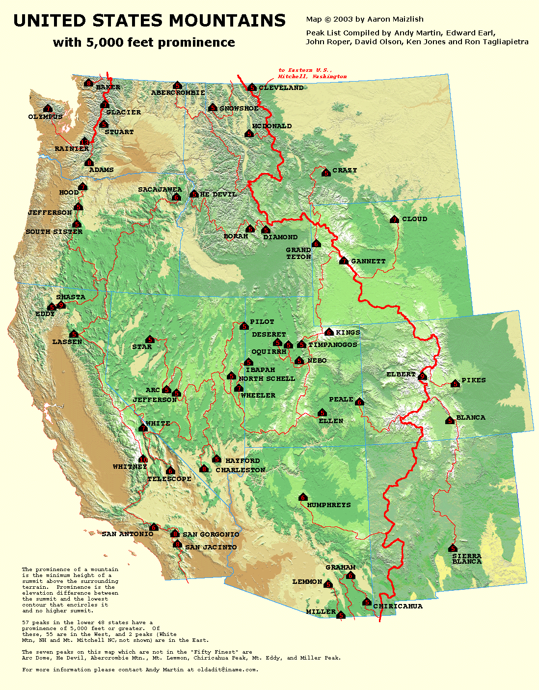
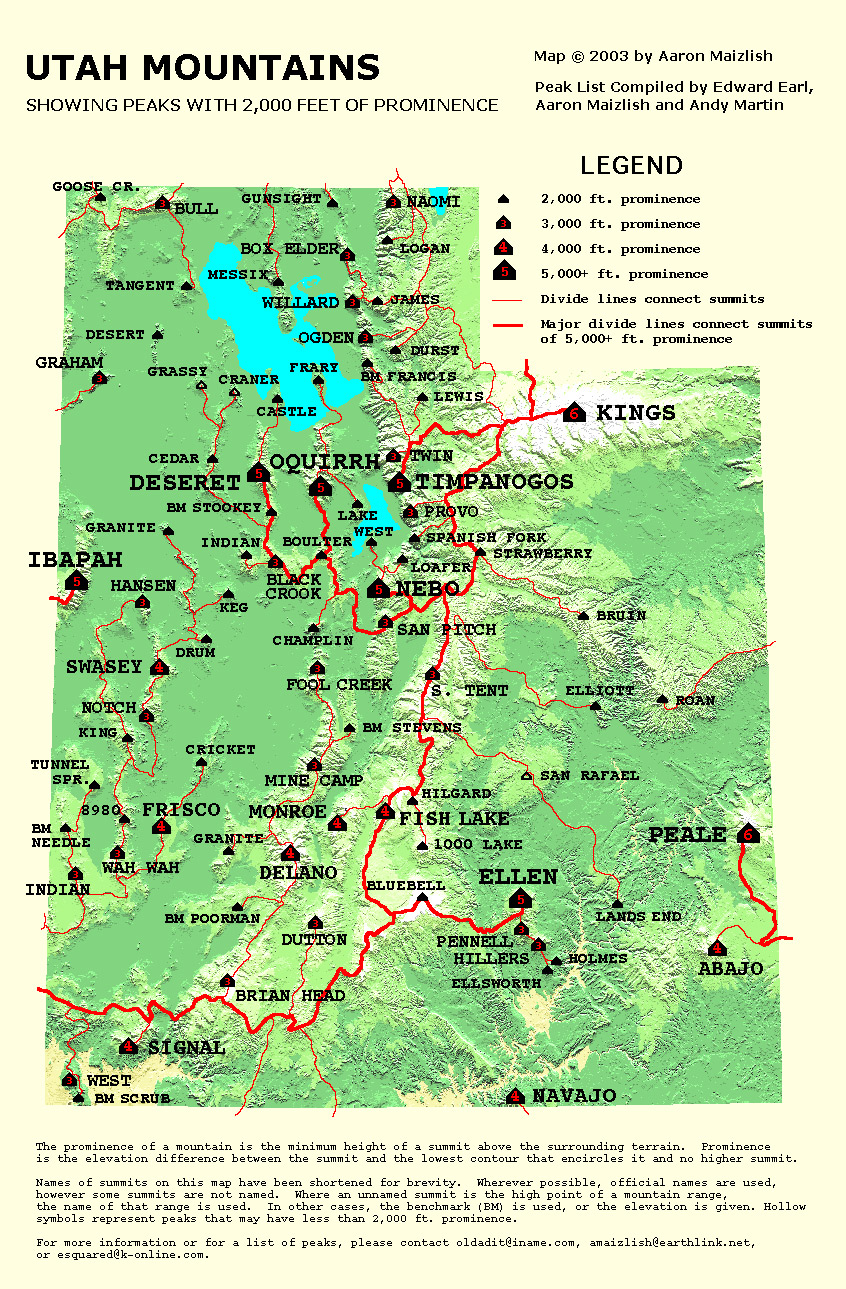
One of 57 5000 foot prominence peaks in the USA
I won't try and explain the concept of Prominence but it is worthy to note that Mt. Timpanogos is one of the 8 5K prominence peaks in the state of Utah. Aaron Maizlish has put together this fantastic map of the Western United States showing the peaks that qualify for this special rating. More information on prominence can be found at
this site, peaklist .org Check out all the maps they have put together,
it'll keep you busy on a rainy weekend.
Utah has 8 5000K prominence peaks:
Kings Peak
Mt. Peale
Mt. Ellen
Mt. Nebo
Mt. Timpanogos
Mt. Ibapah
Deseret Peak
Flattop Peak (in the Oquirrh mtns)
Disclaimer
The Deep Creek Range is in a very isolated part of Utah and you may be the only person in the area at the time of your visit. Do not expect cell phone coverage. Hiking or climbing in a mountain environment has many risks. Any who choose to participate in such activities must assume the responsibility for their own actions and safety. Any information provided here cannot substitute for your own sound judgement and decision making skills. For example, hiking into an electrical storm or during an electrical storm is reckless and dangerous. It is not my intent to describe every risk (weather, rockfall, animals,accidents, etc) that you may encounter on visiting this area but the author of this page is not responsible for your safety. You need to be prepared for the unexpected and proceed accordingly. Roads conditions may worsen and dirt roads can be subject to washing out so be aware of the possibility. Also, in wet conditions, some roads may become impassable. All risks are assumed by the participant(s). Having said that, I wish you a great trip into this beautiful area but exercise care and caution to make your visit a safe one.
Moogie737 - Nov 5, 2012 10:08 pm - Hasn't voted
Parking just after the 1st creek crossingIf you choose to park very shortly after crossing the creek the elevation is about 6,200' and hiking from here adds approximately 2.5 miles r/t. The sharp angular rocks which make this little stretch of road dangerous to tires doesn't last long, but it requires a closer look before you tackle it. Once up the road 500' things get better and the major obstacle to smooth sailing is another creek crossing.
Rigel007 - Aug 16, 2014 7:05 pm - Hasn't voted
trip adviceMade a successful summit on 8/13/14. Notes for others: 1) Mileage: The mileage to various turns in the directions above were all higher than my odometer but the directions as is got me there. It's possible my odometer is the problem, but wanted others to be aware in case it isn't so you don't overshoot the turns; especially the last one into granite creek canyon. 2a) 4x4: You can get to the canyon over the dirt roads in Juab county just fine with any old car on a dry day but will quickly wish you had a high clearance 4wd vehicle in heading up the canyon. Taking anything but a high clearance 4x4 will add several miles to your trip. 2b) My old Ford F150 4x4 was extremely handy on the way out as well due to a major downpour resulting in many sections of the formerly well groomed dirt "highway" being reduced to washed out brush covered sink hole/pseudo rivers. Strong advice is to stay put in the CCC campground if you see a storm brewing to the North when heading back to Wendover regardless of your type of vehicle. 2c) When heading in, if you have a 4x4, there is a section of steep rocks you will need to climb not too far in and after a stream crossing. The other vehicles up there simply didn't attempt it. The way to get up is to stay to the right side as far as possible (drive over a flattish rectangular rock with your right tire next to a tree). Stay on the same side when heading down on your way out. You will only fail if you go up the left side or middle. I wouldn't call it anything serious if you approach it right. 3) If you make it over the steep rocky part in a vehicle, its pretty smooth sailing aside from the heavy brush on both sides of the trail (-1 antenna), and one rocky stream crossing until you reach a final camp site. At the true trail head and right before the aforementioned camp spot the road will swing sharply to the right and open almost immediately to an aspen clearing where you will be greeted with a fire pit and space for several vehicles. It is six miles to the peak from this aspen circled camp site. You will not be able to take a 4 wheeled motorized vehicle further. The fallen trees on the foot trail would make a prohibited motor bike untenable as well. 4) Trail head: The true trail head is unmarked by any signage and is a continuation of the road that brought you up the canyon before it swings sharply to the right and opens to the aspen camp site. You will know it because it is blocked by an iron gate (which you can walk around). The trail from there is as described by others. It's a old jeep/mining road for a while before becoming a winding foot path up to the meadow at 10k feet If you see your first iron gate and take a sharp right down and over a stream then a sharp left, you are not at the trail head or aspen camp site. Keep going where you will find the steep rocks, and several miles later the second metal gate which is the trail head near the aspen camp site. 4b) At the aspen camp site, there is what looks like a trail heading towards the right side of the canyon. If you were to simply go straight through the aspen camp site after taking the sharp right you would be looking directly at it. Do not take that path. It ends quickly and is not an established way to get to the peak. Some dangerous scrambling is all you'll find. 5) The trail between the aspen vehicle camp site and the meadow at 10k feet is very easy to follow with the exception of two spots. If you find yourself off trail, go back to the last known trail location and simply look around until you see where the trail turned. There were several large fallen trees at various points on the trail. There is water in a few places along the as well if you have a filter. There are also two or three camp sites along the trail before the meadow. 6) If I were to do it again, I would park at the aspen site and immediately backpack the 3-4 miles from there and camp at the last site with fire pit just below the meadow. Then summit as early as possible the next day. The primary reason for this is to avoid the afternoon thunderstorms and ensure you have a view when reaching the summit. If you don't do this, make sure you get a very early start from the aspen site. 7) When you get to the meadow hang a right and head directly towards Ibapah. There is no trail through the meadow so just keep heading towards the peak. There is a smaller false peak before Ibapah which you will want to stay to the right of. You do not need to climb it to get onto the ridge. Just go straight and you'll eventually see some cairns to guide you after which point it becomes an easy to follow trail again all the way to the peak. No exposure required. Good luck. There is no cell coverage much beyond Wendover so either don't go alone, or bring a delorme inreach. I did get a few txt messages while on the peak with Verizon service.