
|
|
Mountain/Rock |
|---|---|
|
|
34.28360°N / 118.12°W |
|
|
6164 ft / 1879 m |
|
|
Overview
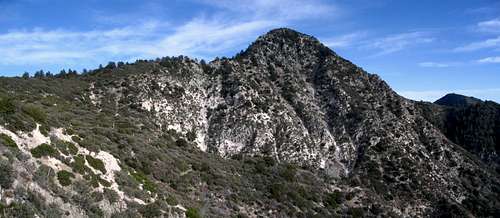
Strawberry Peak is located in the San Gabriel Mountains of Southern California. Just a short drive up Angeles Crest Highway (SR2) from the city of La Cañada. Being so close to the Los Angeles metropolitan area and offering such outstanding hiking opportunities, Strawberry is understandably very popular. The hike up Colby Canyon from hwy 2 passes a seasonal waterfall right near the trailhead, then follows a lush tree filled canyon for the first mile or so, before crossing the stream and heading up the mountain into dryer brushy terrain. The summit offers wonderful views of L.A. and the Pacific Ocean (although often obscured by smog). And to the north the High Desert and Tehachapi mountains are visible. Strawberry Peak got its name according to lore because of it's resemblance to a strawberry standing with its blossom end down.
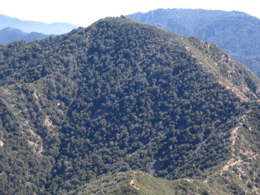
Mt. Lawlor is about a mile to the east of Strawberry Peak and is often climbed in conjunction with Strawberry. From Red Box, hike 2.3 miles to Lawlor Saddle. From the saddle you can go up Strawberry's east ridge or up Lawlor's west ridge.
 |  |  |  |  |
Getting there
 |  |
--Colby Canyon trail is still in bad shape with overgrown vegetation, wash-outs, and sections covered with sand and rocks. Mountain bikers will find the trail unusable. The parking area has "No Parking anytime" signs.
--Red Box trailhead to Lawlor Saddle has been cleared of brush and is in good shape.
--Josephine Peak fire road to Josephine Saddle is in excellent condition.
--Strawberry Peak trail from Camp Colby is closed.(upper Big-T side)
...........................................................................
There are four trailheads accessing Strawberry Peak.
1) Josephine Peak fire road.
2) Colby Canyon
3) Red Box
4) Camp Colby (upper Big-T)
Colby Canyon is used to approach the west ridge and Red Box is the traihead for the east ridge. The Camp Colby approach works for either but is much longer. The Josephine Peak fire road is very popular with mountain bikers.
To reach Strawberry Peak trailheads from the west (Los Angeles area), drive North up the Angeles Crest Highway from the intersection of the 210 (Foothill) freeway.
From the North ( Antelope Valley / Palmdale) areas. Take Angeles Forest Highway (county road-N3) south to Angeles Crest Highway.
~~~~~~~~~~~~~~~~~~~~~~~~~~~~~~~~~~~~~~~~~~~
Colby Canyon
From the 210 fwy. Drive about 9 1/2 miles up the Angeles crest hwy (Rt.2) past the intersection with the Angeles forest hwy. Continue another 3/4 mile. The trailhead is on your left. Park in the dirt pullout. There is a sign at the trailhead.
~~~~~~~~~~~~~~~~~~~~~~~~~~~~~~~~~~~~~~~~~~~
Red Box
Drive up Angeles Crest hwy. about 14 miles from the 210 fwy. and turn right at the Mt. Wilson road intersection. The Red Box picnic area (aka Skyline Park) is located right there. Park in the lot on the east side of the street . From here the trailhead is across the street(Angeles Crest hwy.) and about 50 yds. east. Or park in the dirt turn-out at the trailhead. There is a sign at the trailhead. Strawberry peak trail (12W05).
~~~~~~~~~~~~~~~~~~~~~~~~~~~~~~~~~~~~~~~~~~~
Josephine Peak fire road
Drive up Angeles Crest hwy. about 9 miles, turn left onto Angeles Forest hwy. Park in pullouts on either side of street. The Josephine Peak road (gated) starts across the street from the fire station. Follow the dirt road for 2.5 miles to a point where the road turns left and heads up the north side of Josephine peak. Take the trail to the right (east) for a 1/2 mile to Josephine saddle. Photo
~~~~~~~~~~~~~~~~~~~~~~~~~~~~~~~~~~~~~~~~~~~
Camp Colby (upper Big-T)
From the 210 fwy, take the Sunland blvd. exit and go east about a mile and turn left on Oro Vista st. Oro Vista turns into Big Tujunga Canyon Road, go about 13 miles and turn left on Angeles Forest hwy., then go about 4.5 miles and turn right on Upper Big Tujunga Canyon Road, go 1 mile and turn right onto Camp Colby Road (3N24), go another mile and cross the bridge, the trailhead parking lot will be on your left. You do not need an Adventure Pass to park here.
You can also get there from La Cañada. From the 210 fwy. take Angeles Crest hwy. 9.5 miles and turn left onto Angeles Forest hwy., go about 8.5 miles to Upper Big T Cyn. Road then 1 mile to Camp Colby Road.
From Palmdale Exit hwy. 14 onto Angeles Forest hwy. and go to Upper Big T Road (1 mile past Monte Cristo campground).
If your plan is reaching the summit, this would be the longest approach (it's 12 miles round trip via the east ridge route) but hiking on the north slope of Strawberry Peak is definately worth checking out, especially for those who are looking for more solitude. The trail starts near Camp Colby located off Upper Big Tujunga Canyon Road (see "getting there"), with many of Pines and Oak trees providing lots of shade.
 |  |  |  |
Red Tape
Check the USFS website for information about the closures in effect due to the Station Fire of 2009. Angeles National Forest websiteA National Forest Adventure Pass or America the Beautiful Pass is required to park your car on National Forest land.
For information check the Adventure Pass website.
When To Climb
Strawberry Peak is climbable year round. In the summer it can get hot though. Getting an early start on hot days is recommended. Optimum conditions can be had during the cooler months from October through June.At 6164 feet elevation, snow is not uncommon on Strawberry during the winter months though it melts fast and is not usually an issue. During and after periods of heavy rain, the creek crossings and portions of the trail in the first 1/2 mile of Colby Canyon may be flooded.
Camping
The closest developed Campgrounds to Strawberry Peak are:Monte Cristo Campground.
Located off Angeles Forest Hwy. 9 miles north of the Angeles Crest Hwy. intersection.
Or..
Chilao Campground.
Located off Angeles Crest Hwy. 26 miles N/E from the 210 freeway.
For more information on these and other campgrounds check the NFS website...Click here
Conditions
Weather forecast for La Cañada......Weather forecast for L.A. county mountains.....

External Links
Interesting historical information about Strawberry Peak.
Strawberry Peak Mountainbiking information
Angeles National Forest Information
Josephine Peak Webcam
The Mount Wilson Webcam
Located atop a 150 tower on the summit of Mt. Wilson, this webcam offers fine views of the San Gabriel mountains. The typical view, is looking east towards Mt. Waterman and Twin Peaks, though they often change the direction. Sometimes towards Pasadena, and sometimes towards good 'ol Strawberry Peak, which is only about a mile away, as the crow flies.
~~~~~~~~~~~~~~~~~~~~
>Mapquest
California map
msn road map
Terraserver aerial photo
CalTrans road info. (hwy. 2)
Eleutheros - Nov 25, 2007 7:56 pm - Hasn't voted
Highest In Front RangeHey Rob, You might want to mention this mountain is the highest in the San Gabriel Front Range. -Danny
jerryn - Sep 23, 2013 3:43 pm - Hasn't voted
Colby Canyon Trail Conditions9/13 I understand that the trail to Josephine Saddle is in good condition. The ridge trail from their to the 3rd Class rock is just ok, some route finding required (or so I'm told). Signs still indicate the trail is closed but if what I just wrote is true, there is no good reason for it.