
|
|
Mountain/Rock |
|---|---|
|
|
38.83440°N / 117.3535°W |
|
|
11788 ft / 3593 m |
|
|
Overview & Description
Arc Dome is the highest point in the extensive and well-known Toiyabe mountain range in central Nevada. It is one of the most prominent landmarks in the central Great Basin, and can be seen from countless peaks in Nevada. Arc Dome is also one of the most popular peaks in the state, and for good reason. As the centerpiece of the Arc Dome Wilderness Area, it stands in state over several lush, alpine-like canyons which provide a stark contrast to the desert far below. Hundreds of dayhikers, backpackers, and outfitters take to the trails each year to wander amid this veritable island in the Great Basin (that still could mean less than one per day!). Not only is the peak itself a worthwhile adventure, but just traveling to it will cause the wayfarer to pass a plethora of fascinating & historical locales. Anyone not familiar with this neck of the woods is strongly advised to plan some extra time for sightseeing along the way.
While Arc Dome may be climbed in a day from the edge of the Wilderness Area, it is quite popular to make it an "overnighter" as camping high on the Toiyabe crest can be an unforgettable experience for the lover of the outdoors. The normal route consists of a decent trail which winds through stands of Aspen and Limber Pine before exiting onto a wide plateau overlooking thousands of square miles of scenery. After a mild downhill, the peak is climbed via switchbacks from the north. During clear days, even the Sierra may be glimpsed shimmering in the distance. When on top, one forgets the heat and dust of the desert below.
Dean adds:
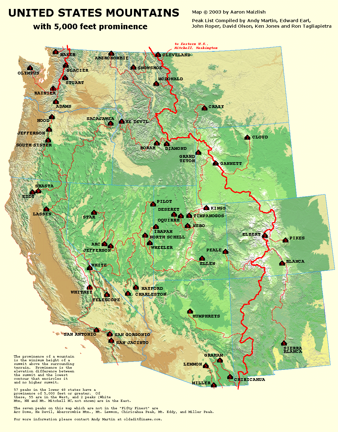
"Arc Dome is also one of the sought after prominence peaks in Nevada as it ranks #8 on the list. It stands out rather dramatically from valleys around it, giving it 5213 feet of prominence. This prominence puts it in an elite group of peaks in the USA that have a prominence of over 5000 feet and those can be seen on this neat MAP HERE. If you don't understand what prominence is all about, here is a good explanation. Adam Helman recently authored a book completely dedicated to prominence.
Mark adds a bit of Arc Dome history & trivia:
"Marge Sill, an environmental activist who has been hiking in Nevada for decades, told me that someone found some Sasquatch prints in the snow in the 1950s.
Visitors to the summit will notice stone foundations of buildings. These buildings once served a healiograph station, said Phil Earl, a Nevada historian. The U.S. government sent soldiers to the peak in the late 1800s to man the station, which used giant mirrors to reflect sunlight and flash messages in morse code. There is some discrepancy among historians I spoke with as to whether the soldiers manned the station year-round.
On Aug. 3, 1945, a WWII bomber en route to Tonopah from Utah crashed into the west-facing slope of the mountain while flying through low-lying clouds during an intense storm. A sheepherder who was interviewed following the accident said he had just moved his camp from the wreckage site hours before the crash because of lightning."
 |
 |
 |
 |
 |
Getting to the Geographical Middle of Nowhere
Arc Dome may be climbed from any angle, and multiple routes are known to be used. The most popular trailhead, Columbine Campground, accesses the peak from Reese River Valley. High clearance is not needed --- RV's have been spotted lumbering up the alluvial fan to the campsites. The nearest highways are State Routes 844 and 722, respectively. Any approach from the NW, N, NE, or E will sooner or later end up on US Highway 50. Approaching from the W or S would require using US 95 or US 6. For the purposes of this section, I will describe a hypothetical journey from Reno, NV.
1) Take I-80 East out of Reno ~25 miles to Fernley
2) Turn onto US 50 (to Fallon) and drive ~77 miles to Middlegate Junction
3) Turn south onto SR 361 (to Gabbs) and drive ~29 miles to the SR 844 junction (to Ione)
4) Turn east on SR 844 and proceed ~15 miles until it turns to dirt
5) Bear left at the "Y" (unless touring the ghost town of Berlin & the Ichthyosaur State Park) and continue another ~7 miles to Ione
6) Continue through Ione (a pseudo-ghost-town) to Reese River (another ~8 miles)
7) At the Reese River Yomba Indian Reservation/USFS Ranger Station continue straight through the 4-way intersection
8) Follow the signs to Stewart Creek/Columbine Campground (~6 miles)
Total: ~180 miles
Always, always, always bring a regional map when cruising the Great Basin --- there aren't gas stations and ATM's everywhere, and cell coverage is limited. But I'm sure you already knew that.
 |
 |
 |
Red Tape
There are no fees for camping or hiking that I am aware of in the Arc Dome region. Of course, contact the USFS for the latest, current, crucial, pertinent, up-to-date, & acute info...
As always in Nevada, stay off the fenced and posted private, and you will be fine.
Climbers should take into account fall big-game hunting seasons: don't duct-tape horns to your dome, and expect to see people if you go during this time.
When To Climb
The comparatively mild snow conditions of the Great Basin offer an extended dayhiking season for those who don't like to gear up for major winter alpine adventures. Early or late-season climbs should be done with waterproof boots and possibly gaiters if there is any snow. Most of the normal route can be seen from the drive in, so scope it out and bring appropriate gear.
The Toiyabes can accumulate more snow than most other Great Basin peaks, so take this into account when doing an off-season expedition. The final 1000' is fairly steep, and during times of complete snow cover an ice axe and crampons may be desired.
Summer hikes should always involve lots of water, as the evaporation rates get quite high in Nevada.
There are a few lower-altitude water sources on this peak --- however, the cows, deer, and feral horses have the run of the springs, so make sure you treat it thoroughly (i.e. boil, etc)! I say always bring your own....
Times of high snow accumulation and/or muddy conditions will hamper driving efforts on the dirt road sections. Have high-clearance and 4WD (and know how to use it) if you go during a potentially stormy day.
Camping, Lodging, and Gas
Camping is available at trailhead areas or on nearby BLM land.
The nearest lodging is Austin (50 miles), Fallon (120 miles), or Tonopah (80 miles).
The nearest gas is Reese River (6 miles, with unknown times of operation), Gabbs (40 miles, one station), or Austin (50 miles, Chevron).
Mountain Conditions are Subject to Rapid Change
Like most Great Basin peaks, this one requires creative research and
a lot of guessing to determine current conditions!
Regional weather may be found by looking up the Austin, Nevada forecast --- about 50 miles away in the north end of the Toiyabes.
 |
technicolorNH - Nov 12, 2016 3:29 am - Hasn't voted
Getting to the Columbine campgroundOnce you pass through Ione you will make it to the tribal reservation with a north/south road. At this point it says go straight at the intersection. Quite simply, you can't because the road isn't there. Go left, drive 100 feet, then turn right on Tribal Route 2. Set your odometer. In .1 miles you will cross the Reese River At 1 mile you will turn right on Columbine Road (it has a sign for Columbine CG there) At 2.7 miles stay right at this intersection (has sign for Stewart and Clear Creek) At 5.6 miles stay right at the sign for the Toiyabe National Forest At 5.7 miles there will be a water crossing (during drought it could be dry) At 6.3 miles there will be a cattle guard At this point continue up the road to the campground a few miles distant. In October of 2016 I did the road in a Honda Civic Hybrid so high clearance should not be needed until snow flies or the road degrades considerably.